

Mori Atlas logo
Nature reserveEstero Padre Ramos Natural Reserve

A complex network of mangrove forests, tidal channels, and critical sea turtle nesting habitats along the Pacific coast

Estero Padre Ramos Natural Reserve: Protected Coastal Wetlands and Estuarine Landscapes in Chinandega Department

(Reserva Natural Estero Padre Ramos)

Estero Padre Ramos Natural Reserve encompasses a significant coastal wetland ecosystem within the Chinandega Department of northwestern Nicaragua. The protected area consists of an extensive mangrove estuary characterized by dense forest stands, brackish lagoons, mudflats, and open sandy beaches lining the Pacific shoreline. This landscape provides a sanctuary for diverse marine life and stands as a globally vital nesting ground for the critically endangered hawksbill sea turtle, representing a primary conservation site for the eastern Pacific region.

mangrove estuaryPacific coastcoastal wetlandshawksbill sea turtlesea turtle nestingbirdwatching

Estero Padre Ramos Natural Reserve

Nature reserve

Park overview

Structured park overview, official facts, and landscape profile for Estero Padre Ramos Natural Reserve

Estero Padre Ramos Natural Reserve park facts, protected area profile, and essential visitor context

Review the core facts for Estero Padre Ramos Natural Reserve, including designation, size, terrain, visitor scale, habitats, and operating context in one park-focused overview.

About Estero Padre Ramos Natural Reserve

Estero Padre Ramos Natural Reserve is a coastal protected area situated in the Chinandega department on the northwest Pacific coast of Nicaragua. It encompasses a broad estuary system where freshwater flows meet the Pacific Ocean, surrounded by a constellation of small beach communities. The town of Padre Ramos is the largest of these settlements, and the reserve takes its name from this local community and the estuary it borders.

The landscape of the reserve blends mangrove forests, brackish lagoons, tidal channels, mudflats, sandy beaches, and stretches of rocky reef. This mosaic of coastal environments supports an unusually rich variety of birdlife, fish, crustaceans, and other wildlife. Beyond its ecological value, the reserve is deeply integrated into the lives of nearby communities, who have historically relied on its natural productivity for fishing, shellfish gathering, livestock, and small-scale agriculture.

Estero Padre Ramos stands out on the global conservation stage largely because of its role in the survival of the hawksbill sea turtle in the eastern Pacific. The discovery that hawksbills continue to nest here in meaningful numbers transformed scientific understanding of the species in the region and turned the reserve into a focal point for international marine turtle research and community-based conservation. The combination of an extensive mangrove estuary and globally important turtle nesting beaches gives the reserve a distinctive protected-area identity within Nicaragua and the wider Pacific coast of Central America.

Quick facts and research context for Estero Padre Ramos Natural Reserve

Estero Padre Ramos Natural Reserve covers roughly 92 square kilometers of coastal ecosystems in northwest Nicaragua, within the Chinandega department. It was declared a protected area in 1983 and is administered by the Ministry of the Environment and Natural Resources, MARENA.

The reserve is classified as an IUCN Category IV area, recognizing its role in managing habitats and species of conservation concern. Its defining features include mangrove estuary habitat and globally significant hawksbill sea turtle nesting beaches, as well as mudflats, sandy beaches, rocky reefs, and surrounding small coastal communities.

Protection and recognition

Examine documented protection scope and official international recognition records.

Estero Padre Ramos Natural Reserve Protection Status and Governance Data

Estero Padre Ramos Natural Reserve maintains a mixed protection scope supported by recorded management data and conservation frameworks. Structured conservation records outline the official governance measures and administrative designations assigned to the protected landscape.

Protection details

Protection scope
Mixed
Transboundary protection
No
Park context

Deeper park guide and search-rich context for Estero Padre Ramos Natural Reserve

Estero Padre Ramos Natural Reserve history, landscape, wildlife, and travel context

Explore Estero Padre Ramos Natural Reserve through its history, landscape character, ecosystems, wildlife, conservation priorities, cultural context, and seasonal travel timing in a structured park guide built for atlas discovery and search intent.

Why Estero Padre Ramos Natural Reserve stands out

Estero Padre Ramos is best known internationally as one of the two primary nesting habitats for the critically endangered hawksbill sea turtle in the eastern Pacific Ocean. Each season, an estimated 150 to 300 hawksbills emerge to nest on its beaches, representing roughly half of all documented hawksbill nesting in the entire eastern Pacific. Alongside this turtle significance, the reserve is also recognized for its extensive mangrove estuary, one of the most pristine estuarine ecosystems along Nicaragua's Pacific coast. The combination of mangrove forests, tidal channels, and adjacent nesting beaches gives the reserve a dual identity as both a wetland habitat reserve and a marine turtle stronghold.

Estero Padre Ramos Natural Reserve history and protected-area timeline

Estero Padre Ramos Natural Reserve was officially declared a protected area on September 9, 1983. Its establishment reflected growing recognition of the ecological value of Nicaragua's Pacific mangrove estuaries and the need to conserve coastal habitats that supported both biodiversity and traditional community livelihoods.

Since that designation, the reserve has been managed by Nicaragua's Ministry of the Environment and Natural Resources, MARENA. Over time, the area's significance grew beyond its national status when researchers identified Estero Padre Ramos as one of the principal remaining nesting grounds for hawksbill sea turtles in the eastern Pacific. This discovery, together with parallel findings at Bahia Jiquilisco in El Salvador, reshaped conservation expectations for the species in the region and brought new research and community-based conservation initiatives to the site, including work by the Eastern Pacific Hawksbill Initiative and a private sea turtle rescue project at nearby Jiquilillo run by MSV Nicaragua.

Estero Padre Ramos Natural Reserve landscape and geographic character

The reserve's landscape is defined by a wide mangrove estuary where tidal channels weave through dense stands of mangrove forest. Beyond the mangrove fringe, the terrain transitions into brackish lagoons, expansive mudflats exposed at low tide, and stretches of sandy beach that line the Pacific coast. Scattered sections of rocky reef punctuate the shoreline, adding structural diversity to an otherwise soft-sediment coastal setting.

Surrounding the estuary is a chain of small beach communities, including the town of Padre Ramos, that have grown up along the coast. The combination of sheltered waters, open beaches, and vegetated tidal flats creates a varied coastal topography in a relatively compact area, giving the reserve a layered character where estuary, shoreline, and human settlement meet.

Estero Padre Ramos Natural Reserve ecosystems, habitats, and plant life

Ecologically, Estero Padre Ramos is dominated by mangrove forest ecosystems that fringe the estuary and form the core of its biological productivity. These mangroves stabilize sediments, filter land runoff, and provide essential nursery habitat for fish, crustaceans, and other marine organisms. Behind and between the mangroves, the reserve encompasses mudflats, sandy beaches, and rocky reefs, each contributing distinct ecological functions.

The interface between freshwater, brackish, and saltwater environments supports a diverse coastal food web. The mangrove estuary's productivity underpins populations of commercially and ecologically important fish and shellfish species, sustaining both wildlife cycles and traditional fishing by surrounding communities. This combination of habitat types makes the reserve one of the most ecologically rich coastal zones on Nicaragua's Pacific coast.

Estero Padre Ramos Natural Reserve wildlife and species highlights

Estero Padre Ramos supports a wide variety of resident and migratory wildlife tied to its mangroves, mudflats, and beaches. The reserve is a recognized habitat for numerous bird species, including migratory shorebirds and waterbirds that use the estuary as a stopover or wintering site along the Pacific flyway. Fish and crustaceans thrive in the mangrove-rooted channels, where juveniles find shelter before moving to open coastal waters.

The reserve's most internationally significant wildlife feature is its role as a major hawksbill sea turtle nesting area in the eastern Pacific. Each season, an estimated 150 to 300 hawksbills come ashore to nest on the reserve's beaches, accounting for a substantial share of all known hawksbill nesting in the region. Olive ridley sea turtles also nest here, adding to the site's importance for Pacific marine turtles. The year-round presence of hawksbills within the estuary itself has been viewed by researchers as a new life-history pattern for the species, distinct from the coral reef associations observed elsewhere.

Estero Padre Ramos Natural Reserve conservation status and protection priorities

Estero Padre Ramos holds conservation significance at both national and international levels. Nationally, it forms part of Nicaragua's network of protected areas and preserves one of the most intact mangrove estuaries on the country's Pacific coast, safeguarding habitat types that are increasingly threatened elsewhere in the region. The reserve's IUCN Category IV designation underscores its role in managing sensitive habitats and species rather than being set aside purely for wilderness preservation.

Globally, the reserve's importance is defined by its hawksbill sea turtle population. As one of only two principal hawksbill nesting sites known in the entire eastern Pacific, it represents a critical stronghold for a critically endangered species. Protection of nesting beaches, monitoring of nesting females, and coordinated research have become central conservation activities at the site. Conservation work is carried out in collaboration with local community groups and nonprofit organizations, including the Eastern Pacific Hawksbill Initiative, reflecting a community-based approach to long-term protection of both turtles and the broader estuarine ecosystem.

Estero Padre Ramos Natural Reserve cultural meaning and human context

The reserve is closely intertwined with the daily lives and livelihoods of the small coastal communities that ring the estuary, the largest of which is the town of Padre Ramos. Local residents have long depended on the estuary's natural productivity for fishing, shellfish gathering, and small-scale agriculture, and livestock rearing and shrimp farming also occur in the surrounding area. This long-standing coexistence between people and ecosystem has shaped both community identity and management approaches.

Conservation efforts at the site place strong emphasis on working alongside local community groups, reflecting the recognition that the reserve's long-term protection depends on the people who live adjacent to it. This blend of traditional coastal livelihoods and modern conservation partnerships is an important part of the reserve's social context.

Top sights and standout views in Estero Padre Ramos Natural Reserve

Estero Padre Ramos stands out for combining one of the most pristine mangrove estuaries on Nicaragua's Pacific coast with globally significant hawksbill sea turtle nesting beaches. Roughly half of all known hawksbill nesting in the eastern Pacific occurs here each season, a fact that places this modest-sized Nicaraguan reserve at the center of international marine turtle conservation.

Equally notable are the reserve's mixed coastal habitats: mangrove stands, tidal channels, mudflats, sandy beaches, and rocky reefs supporting diverse birdlife, fish, and crustaceans. The presence of thriving wildlife alongside active small coastal communities creates a landscape where ecological value and traditional coastal life continue to coexist.

Best time to visit Estero Padre Ramos Natural Reserve

The most ecologically dramatic period to consider visiting Estero Padre Ramos is the hawksbill turtle nesting season, when female turtles come ashore on the reserve's beaches. This seasonal nesting activity shapes a key part of the reserve's identity and influences when guided nature experiences around turtles are most meaningful.

Outside of nesting peaks, periods when migratory birds are present along the Pacific coast, and seasons with stable tidal and weather conditions favorable for exploring the mangrove channels and beaches, tend to provide rewarding conditions for general nature observation. Visitors interested primarily in mangrove scenery, birdwatching, and quiet beach landscapes can find the reserve rewarding whenever conditions favor coastal exploration, with tourism within the area remaining relatively controlled year-round.

Monthly climate preview

Long term temperature averages and monthly precipitation records for Estero Padre Ramos Natural Reserve

Estero Padre Ramos Natural Reserve Climate Normals and Annual Weather Patterns

Representative coordinate data reveals distinct monthly shifts in average temperature and precipitation across Estero Padre Ramos Natural Reserve throughout the year. Examining the full twelve month climatological profile provides deeper insight into measured meteorological patterns at this protected location.
Annual mean29 °C
28 °C30 °C
Jan29°
Feb29°
Mar30°
Apr30°
May29°
Jun29°
Jul29°
Aug29°
Sep28°
Oct28°
Nov28°
Dec28°
Warmest month
April

30.2 °C

Coolest month
October

27.6 °C

Wettest month
September

8.5 mm/day

Driest month
January

0.1 mm/day

Park location guide

Geography guide, regional context, and park location map for Estero Padre Ramos Natural Reserve

Estero Padre Ramos Natural Reserve park geography, regions, and map view in Nicaragua

Understand where Estero Padre Ramos Natural Reserve sits in Nicaragua through a broader geographic reading of the surrounding landscape, nearby location context, and its mapped position within the national park landscape.

How Estero Padre Ramos Natural Reserve fits into Nicaragua

Nicaragua is a Central American country spanning 130,375 km² with a population of approximately 6.7 million. It borders Honduras, Costa Rica, the Caribbean Sea, and the Pacific Ocean. The official language is Spanish, and the currency is the Córdoba. Known for its agricultural productivity and cultural diversity, Nicaragua has a history dating back to indigenous civilizations before Spanish conquest in the 16th century.

Wider geography shaping Estero Padre Ramos Natural Reserve in Nicaragua

Nicaragua occupies a strategic position in Central America, bordered by Honduras to the north, the Caribbean Sea to the east, Costa Rica to the south, and the Pacific Ocean to the west. The country also shares maritime borders with El Salvador and Colombia. The terrain includes coastal plains, volcanic highlands, and interior valleys. Lake Managua and Lake Nicaragua are major freshwater bodies.

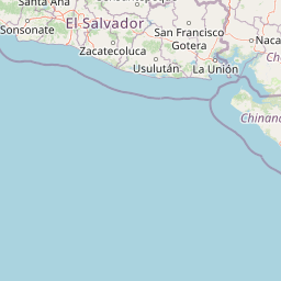
Map view of Estero Padre Ramos Natural Reserve

Use this park location map to pinpoint Estero Padre Ramos Natural Reserve in Nicaragua, understand its exact geographic position, and read its mapped placement within the surrounding landscape more clearly.

Pigeon | © OpenStreetMap contributors

Location context for Estero Padre Ramos Natural Reserve

Chinandega Department
Recorded earthquake history

Examine Recorded Earthquake History Near Estero Padre Ramos Natural Reserve

Browse the documented catalogue of seismic activity occurring within the proximity of Estero Padre Ramos Natural Reserve. This data repository, powered by MoriAtlas, offers researchers and geography enthusiasts a clear view of historical earthquake records associated with this important Nicaraguan coastal region.

Estero Padre Ramos Natural Reserve Earthquake History

Catalogued events

462 events

Strongest magnitude

Magnitude 6.5

Most recent event

Jul 8, 2026

This history includes earthquakes recorded inside the park or within 50 km of its borders

Park atlas

Compare surrounding coastal ecosystems, mangrove estuaries, and regional reserves

Parks Near Estero Padre Ramos Natural Reserve and Regional Protected Landscapes

Browsing other protected areas near Estero Padre Ramos Natural Reserve helps reveal broader regional geography along the Pacific coastline. Comparing adjacent coastal wetlands and marine reserves expands your understanding of tropical conservation landscapes.
Nature reserveChinandega Department
About 3.8 km away#1 closest

Northwest

Cosigüina Peninsula Nature Reserve: Geographic Overview and Protected Landscape Mapping

A coastal volcanic reserve in Chinandega Department.

The Cosigüina Peninsula represents a vast protected territory where volcanic slopes meet the Gulf of Fonseca. This nature reserve includes critical mangrove systems, tidal wetlands, and offshore islets. The area serves as a primary geographic anchor for northwestern Nicaragua, offering deep insights into the region's complex coastal and volcanic landforms and its status as a vital protected wildlife refuge.

Established
1958
Relief
Mixed relief
Access
Access unknown
Scope
Mixed
Nature reserveManagua Department
About 153 km away#2 closest

Southeast

Chocoyero-El Brujo Natural Reserve: Geographic Overview and Protected Landscape Mapping

Tropical ravine forest and critical watershed in Managua Department.

This nature reserve protects a vital intersection of tropical forest and steep ravine terrain. Centered on the iconic El Brujo and Chocoyero waterfalls, the area acts as a crucial watershed and nesting ground for green parakeet colonies. The compact, vertical landscape provides a unique look at how small protected areas maintain biodiversity and regional water security near the capital of Nicaragua.

Area
1.8 km²
Established
1993
Visitors
10K annual
Relief
Upland
National parkFrancisco Morazán Department
About 154 km away#3 closest

North

La Tigra National Park: Mapped Protected Landscape in Francisco Morazán Department, Honduras

Explore its geography and protected area context.

La Tigra National Park serves as a key protected area within the Francisco Morazán Department, offering rich opportunities for geographic and landscape discovery. This national park's specific mapped boundaries and regional context are vital for understanding its role within Honduras's protected lands. Engage with its geography to appreciate the unique characteristics of this important natural landscape.

Area
238.21 km²
Established
1980
IUCN
II
Relief
Mountain
National parkNicaragua
About 159 km away#4 closest

Southeast

Masaya Volcano National Park: Nicaragua National Park Atlas & Landscape Context

Explore the mapped boundaries of this unique volcanic terrain.

Masaya Volcano National Park offers a distinct focus for atlas exploration within Nicaragua's broader geographic framework. This page details the park's identity as a protected landscape, highlighting its volcanic terrain and mapped features. Understand its significance within the national park system and its contribution to the mapped natural heritage of Central America.

IUCN
II
Relief
Mountain
Access
Access unknown
Nature reserveNicaragua
171 km away#5 closest

Southeast

Laguna de Apoyo Nature Reserve: Geographic Profile and Protected Volcanic Caldera

A study of volcanic lake hydrology and tropical dry forest terrain.

Laguna de Apoyo Nature Reserve is a prominent protected landscape in Nicaragua, centered on a deep crater lake of volcanic origin. This nature reserve protects a circular caldera filled by an endorheic lake, ringed by diverse tropical dry forest. The area serves as a significant site for understanding geological landforms and the specialized freshwater biodiversity found within its sheltered basin.

Area
35 km²
Established
1991
IUCN
IV
Relief
Mixed relief
National parkHonduras
About 180 km away#6 closest

North

Montaña de Comayagua National Park: Honduras National Park and Protected Area Geography

Explore mapped boundaries and natural terrain within Central America.

Montaña de Comayagua National Park stands as a vital protected area, contributing significantly to the geographic tapestry of Honduras. This national park offers a focused perspective for atlas exploration, allowing users to trace its mapped boundaries and comprehend its role within the regional landscape. Delve into the park's protected identity and its unique position in the mapped geography of Central America.

Area
184.8 km²
Established
1987
IUCN
II
Relief
Mountain
Nature reserveNicaragua
198 km away#7 closest

East

Cerro Pancasan Natural Reserve: Geographic Overview of a Nicaraguan Protected Forest Hill

Exploring mountain-slope terrain and regional watershed conservation

As a significant hill reserve in western Nicaragua, Cerro Pancasan Natural Reserve protects essential tropical forest cover against agricultural encroachment. This entry provides a detailed look at the reserve's topography, its role in maintaining regional stream flow, and its place within the country-wide SINAP network of protected land.

Scope
Terrestrial
National parkNicaragua
About 203 km away#8 closest

Southeast

Zapatera Archipelago National Park: Nicaragua National Park Atlas and Protected Landscape Explorer

Explore the mapped boundaries and regional geography.

Zapatera Archipelago National Park serves as a distinct national park within Nicaragua, offering a focused point for exploring protected landscapes and their geographic context. This entry details the park's mapped boundaries and its significance within the atlas of Central American natural areas. Users can understand its role as a protected entity and its contribution to the region's mapped geography, supporting structured discovery of its natural landscape identity.

IUCN
II
Climate
Tropical
Scope
Mixed
Water
Water-dominated

Common questions about visiting, size, designation, and location context for Estero Padre Ramos Natural Reserve

Estero Padre Ramos Natural Reserve FAQs for park facts, access, geography, and protected area context

Find quick answers about Estero Padre Ramos Natural Reserve, including protected-area facts, park geography, trail and visitor context, and how the park fits into its surrounding country and regional landscape.
MoriAtlas Explorer

Continue Your Protected Areas Search Across the Global Atlas

Deepen your exploration by continuing the structured search for national parks and protected areas worldwide. Utilize the comprehensive filtering capabilities to compare different conservation landscapes and refine your understanding of global park geography. Discover more about the distribution and characteristics of protected natural areas.

Global natural geography