
Mori Atlas logo
Nature reserveFestberg bei Philippinenthal

Mapping the steep limestone slopes, calcareous grasslands, and floodplain forest ecosystems.

Festberg bei Philippinenthal Nature Reserve: A Protected Muschelkalk Landscape in Hessen

(Naturschutzgebiet Festberg bei Philippinenthal)

Festberg bei Philippinenthal is a significant nature reserve in the Hessen region, centered on a 330-meter hill formed by tilted Lower Muschelkalk limestone strata. The protected area features a dramatic southwest-facing slope that drops toward the Lohbach stream, creating a complex mosaic of juniper heath, orchid-rich calcareous grasslands, and alder-ash floodplain forests. This landscape reflects centuries of traditional grazing and currently serves as a critical European FFH site for preserving rare, warmth-loving vegetation in northern Germany.

calcareous grasslandlimestone habitatjuniper heathorchid-rich grasslandFFH siteNaturschutzgebiet
A flat-style vector illustration of a waterfall cascading down a cliff face into a river, surrounded by pine trees and mountains under a stylized sun.

Festberg bei Philippinenthal

Nature reserve

Park overview

Structured park overview, official facts, and landscape profile for Festberg bei Philippinenthal

Festberg bei Philippinenthal park facts, protected area profile, and essential visitor context

Review the core facts for Festberg bei Philippinenthal, including designation, size, terrain, visitor scale, habitats, and operating context in one park-focused overview.

About Festberg bei Philippinenthal

Festberg bei Philippinenthal is a compact but ecologically rich protected landscape in the rolling hill country of northern Hesse. Its name refers to the Festberg, a roughly 330 meter hill a few kilometers northeast of Wolfhagen's town center, whose southwest-facing flank rises steeply above the course of the small Lohbach stream. The reserve was created to protect exactly that transition from valley floor to sun-exposed limestone slope, where centuries of grazing and the underlying Muschelkalk geology have produced an unusually well-developed calcareous grassland landscape.

Administratively, the site lies within the Naturpark Habichtswald and within the natural region of the Wolfhager Hügelland, part of the Ostwaldecker Randsenken in the broader Westhessisches Bergland. Geologically, the Festberg consists of Lower Muschelkalk limestones whose beds were tilted by the subsidence of the adjacent Altenhasunger Graben. The resistant limestone layers form a narrow ridge that falls sharply toward the southwest, where shallow soils and exposed rock create the dry, warm conditions that give the site its particular character.

Land use shaped the Festberg long before it became a protected area. The terrain was unsuitable for arable farming and until around the middle of the twentieth century it was used as common grazing land for the village of Altenhasungen. Goats and sheep cropped the vegetation, suppressing woody regrowth and allowing warmth-loving and drought-tolerant plants and animals to colonize the open swards. As traditional grazing declined, shrubs began to invade, and from the mid-1990s onward conservation management has reintroduced grazing with Heidschnucken and goats, alongside other stewardship measures, to restore the open calcareous character of the hillside.

Today Festberg bei Philippinenthal is protected both as a German Naturschutzgebiet and as an EU Habitats Directive site, and it is recognized for combining several different calcareous habitat types in a small area. The mosaic of orchid-rich limestone grassland, juniper heath, calcareous scrub, small pine stands with broadleaf admixture, a stretch of the near-natural Lohbach with alder-ash floodplain forest, and surrounding orchard and grassland parcels makes it a meaningful example of how a single hillside can carry a layered, semi-natural landscape of considerable conservation value.

Quick facts and research context for Festberg bei Philippinenthal

Festberg bei Philippinenthal lies within the Naturpark Habichtswald, north of the town center of Wolfhagen in the Kassel district of northern Hesse. It was designated as a nature reserve in 1992 by the regional authority at Kassel and designated as a Fauna-Flora-Habitat site in 2004 under the EU Habitats Directive.

The protected area covers the southwest slope and ridge of the Festberg, a 330 meter hill of Lower Muschelkalk limestone, and extends from about 270 meters above sea level in the Lohbach valley up to roughly 325 meters on the ridge crest. Its habitat mosaic includes orchid-rich calcareous grassland, juniper scrub, lime-loving shrub communities, a stretch of the near-natural Lohbach stream with accompanying floodplain woodland, and traditional orchard meadows, which together support a flora and fauna assemblage described as unique in this combination for western northern Hesse.

Protection and recognition

Documented Natura 2000 listings and verified international protection records

Festberg bei Philippinenthal Protection Status and International Recognition Data

Festberg bei Philippinenthal holds documented protection status through verified Natura 2000 designations and official database records. Review the complete international recognition framework alongside structured administrative data for this protected area.
Park context

Deeper park guide and search-rich context for Festberg bei Philippinenthal

Festberg bei Philippinenthal history, landscape, wildlife, and travel context

Explore Festberg bei Philippinenthal through its history, landscape character, ecosystems, wildlife, conservation priorities, cultural context, and seasonal travel timing in a structured park guide built for atlas discovery and search intent.

Why Festberg bei Philippinenthal stands out

The reserve is best known for its orchid-rich limestone grassland and juniper heath on a steep, sun-warmed Muschelkalk slope. These open calcareous habitats, together with the calcareous scrub communities rich in barberry, wild rose, privet, dogwood and juniper, form a distinctive combination of dry-grassland and shrub habitats rarely found in this composition elsewhere in western northern Hesse. It is also notable for the way its ecological character has been shaped by centuries of traditional grazing. Sheep and goat pasturing kept the hillside open and allowed warmth-loving, drought-tolerant species to establish; when that grazing stopped the slopes began to scrub over, and conservation management now relies on Heidschnucken and goats to maintain the open calcareous character that defines the site.
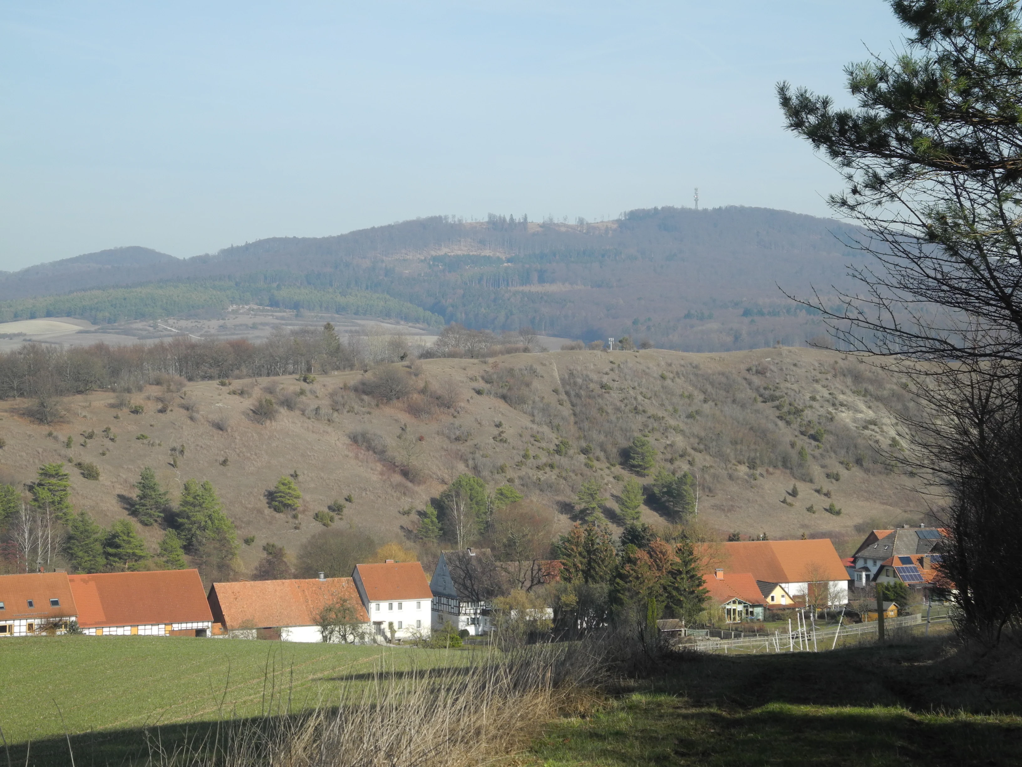
A wide landscape view of a hilly nature reserve with a rural village nestled in the foreground, under a clear sky.
A view of the landscape at Festberg bei Philippinenthal, featuring rolling hills and the village outskirts.

Festberg bei Philippinenthal history and protected-area timeline

The Festberg has a long history as a working agricultural landscape rather than as wilderness. Because its shallow, rocky soils on Lower Muschelkalk limestone were unsuited to ploughing, the hill was used as communal grazing land, or Hutewald, by the nearby village of Altenhasungen. Up until around the middle of the twentieth century, sheep and especially goats grazed the slope, keeping woody growth in check and creating the open conditions on which the site's distinctive dry grassland depended.

When that traditional land use faded in the second half of the twentieth century, the hillside began to scrub over. Brush and tree seedlings encroached on the previously open calcareous grassland, threatening the very species composition that had built up under grazing. Concern about this loss led, on 21 October 1992, to formal designation of the Festberg bei Philippinenthal as a Naturschutzgebiet by the Obere Naturschutzbehörde at the Regierungsbezirk Kassel.

In 2004 the area was additionally reported, within the same boundaries, as a Fauna-Flora-Habitat site under the European Union Habitats Directive, giving it both national and European conservation status. From the mid-1990s, active management reintroduced grazing with Heidschnucken and goats from late May through the end of summer, along with other stewardship measures, to reverse the scrub encroachment and preserve the open, species-rich character that historically defined the Festberg.

Festberg bei Philippinenthal landscape and geographic character

The Festberg is a compact, ridge-like hill that reaches roughly 330 meters above sea level, set in the gentle Wolfhager Hügelland of northern Hesse. Its defining landscape feature is the sharp contrast between the flat crest and the steep, almost cliff-like southwest flank, which plunges about 60 meters down to the narrow valley of the Lohbach stream. This steep, exposed slope is what gives the reserve most of its visual drama, and it is the same exposure that creates the dry, sunny microclimate on which the grassland depends.

At its base, the reserve includes a narrow strip along the Lohbach, a small Erpe tributary that follows the line of the Altenhasunger Graben between the hill and the village of Altenhasungen. Along the foot of the slope, traces of small former limestone quarries can still be seen, reminders of earlier local use of the Muschelkalk bedrock. Above this valley edge, the protected area climbs through a mixture of open grassland, scattered shrubs and small woodland strips up to the hilltop ridge.

Around the hill runs a farm and forestry track, while across the crest a footpath links the reserve to the surrounding landscape. To the east, the higher Großer Bärenberg with its observation tower provides a wider regional viewpoint; to the southwest, the hillside looks directly down toward the village of Philippinenthal. The overall impression is of a small, sharply drawn hill whose limestone skeleton still shapes the way its soils, vegetation and human use have evolved.

Festberg bei Philippinenthal ecosystems, habitats, and plant life

Ecologically, the Festberg bei Philippinenthal is unusual in its region for the way it concentrates several calcareous habitat types on a single small hillside. The reserve protects four habitat types of community interest under the EU Habitats Directive, each with its own character: juniper formations on calcareous heath and grassland, near-natural calcareous dry and semi-dry grasslands, a small stretch of the Lohbach with vegetation of the floating water crowfoot type, and alder-ash floodplain woodland along the stream.

The most conspicuous ecological feature is the calcareous semi-dry grassland, which in parts is strikingly orchid-rich and historically carried bee orchid and fly orchid populations, along with gentians and cat's-foot. Around it, juniper heath has expanded in places where the original grassland has not been maintained, while on the hottest, stoniest parts of the slope, dense calcareous scrub dominated by common barberry, with wild roses, privet, dogwood and juniper, forms a thicket habitat of considerable value in its own right.

On the upper parts of the hill, small pine stands intermixed with broadleaf trees give way to more open ground, while along the very bottom of the protected area the near-natural run of the Lohbach and its accompanying strip of black alder and ash floodplain woodland add a distinct, moisture-loving element to the otherwise dry hillside. Surrounding parcels of orchard meadow and grassland extend the semi-natural landscape beyond the core reserve.

Festberg bei Philippinenthal wildlife and species highlights

The Festberg's wildlife significance is closely tied to its mosaic of dry, warm calcareous habitats and the small, near-natural stream that runs along its foot. The combination of open limestone grassland, juniper scrub, lime-loving shrub communities and a shaded stretch of the Lohbach provides habitat for warmth-loving invertebrates, including the rich insect fauna associated with its orchid populations and with the barberry- and juniper-dominated scrub.

The alder-ash floodplain strip along the Lohbach, although small, supports the aquatic and amphibious communities typical of low-energy watercourses at the foothills of the Westhessisches Bergland, while the surrounding orchard meadows and grassland provide additional foraging habitat for common farmland and edge species. Grazing animals themselves are also part of the site's current wildlife character: Heidschnucken and goats from late May through the end of summer act as a living management tool, mimicking the historic grazing that originally created the open hillside.

Festberg bei Philippinenthal conservation status and protection priorities

As a designated Naturschutzgebiet and an EU Habitats Directive site, Festberg bei Philippinenthal has a clear double conservation status. The 1992 national designation gave the area its baseline protection from damaging land-use change, while the 2004 FFH listing placed the Festberg within the European network for the protection of habitats and species, with a reporting obligation on habitat condition.

The reserve is valued not only for its remaining orchid-rich limestone grassland but also for the calcareous scrub and early-stage woodland that fringe it. The dense barberry stands, juniper thickets and pre-forest stages on the steep slope are recognized as integral parts of the site's conservation importance, rather than as undesirable degradation of open grassland, and are protected as such.

Active management is central to the conservation story. The mid-twentieth-century end of traditional grazing triggered scrub encroachment, threatening both the open calcareous grassland and its associated orchid flora. Since the mid-1990s, seasonal grazing with Heidschnucken and goats, supported by other stewardship measures, has been used to keep the hillside open and to push back woodland succession. Habitat condition reporting under the FFH framework assigns the calcareous dry grasslands the most favorable status, with the juniper formations and the stream habitats classed as in good but slightly less favorable condition.

Festberg bei Philippinenthal cultural meaning and human context

The cultural context of the Festberg is rooted in its long use as common grazing land for the village of Altenhasungen. As a Hutewald, the hill was not wilderness but a working part of the local agricultural economy: the terrain's shallow limestone soils and steep slopes made ploughing impossible, but they were well suited to hardy sheep and especially goats, whose browsing kept the hillside open and shaped the landscape that later became the basis for conservation value.

The hill is also part of the setting of Philippinenthal, a historic village suburb at its foot. Originally the seat of the nearby Philippinenburg estate, Philippinenthal is closely associated with the Festberg in landscape terms; the reserve is named for the hill in relation to this settlement rather than after a major administrative unit. The Großer Bärenberg, visible behind the Festberg to the east, carries an observation tower that marks the hill as a familiar local landmark.

Top sights and standout views in Festberg bei Philippinenthal

A steep 330 meter Muschelkalk ridge above the narrow valley of the Lohbach, with a sharp drop to the southwest that defines the reserve's character. A rare, in this composition unique for western northern Hesse, mosaic of orchid-rich calcareous grassland, juniper heath and lime-loving scrub on a small hillside. A protected area with both national and European conservation status, designated as a Naturschutzgebiet in 1992 and as an FFH site in 2004. Active conservation grazing with Heidschnucken and goats that links modern management to centuries of traditional land use. A small but ecologically layered landscape that combines dry hilltop calcareous habitats with a near-natural stream and a strip of alder-ash floodplain forest at the foot of the slope.

Best time to visit Festberg bei Philippinenthal

Late spring into high summer is when the Festberg is at its most expressive, as the orchids, gentians and other calcareous grassland flowers come into bloom and the juniper and barberry scrub is in full leaf. This is also the period when the seasonal grazing by Heidschnucken and goats is underway, which keeps the swards open and the landscape views across the slope unobstructed. Shoulder seasons can still be rewarding for the structure of the landscape, the sweeping ridge views toward the Großer Bärenberg and the contrast between the dry slope and the shaded Lohbach below, though the most striking displays of the reserve's specialized flora are concentrated in the warmer months.

Monthly climate preview

Long-term representative monthly temperature and precipitation patterns across the protected terrain

Festberg bei Philippinenthal Climate Normals and Annual Temperature Rhythm

Representative coordinates record long-term monthly temperature shifts and precipitation rates for Festberg bei Philippinenthal from historical NASA measurements. Detailed monthly breakdowns provide complete baseline climate profiles and temperature averages across the designated protected area.
Annual mean8 °C
-1 °C18 °C
Jan-1°
Feb
Mar
Apr
May12°
Jun16°
Jul18°
Aug18°
Sep14°
Oct
Nov
Dec
Warmest month
July

18 °C

Coolest month
January

-0.6 °C

Wettest month
July

2.5 mm/day

Driest month
April

1.5 mm/day

Park location guide

Geography guide, regional context, and park location map for Festberg bei Philippinenthal

Festberg bei Philippinenthal park geography, regions, and map view in Germany

Understand where Festberg bei Philippinenthal sits in Germany through a broader geographic reading of the surrounding landscape, nearby location context, and its mapped position within the national park landscape.

How Festberg bei Philippinenthal fits into Germany

Germany is a federal republic in Western and Central Europe with a population of over 83 million across sixteen constituent states. It is Europe's largest economy by nominal GDP and a major global exporter and importer. The capital is Berlin, and the country borders Denmark, Poland, Czech Republic, Austria, Switzerland, France, Luxembourg, Belgium, and the Netherlands.

Wider geography shaping Festberg bei Philippinenthal in Germany

Germany is located in Western and Central Europe, spanning 357,022 km². It borders Denmark to the north, Poland and the Czech Republic to the east, Austria and Switzerland to the south, and France, Luxembourg, Belgium, and the Netherlands to the west. The country has coastlines on the Baltic Sea and North Sea to the north, with the Alps located in the southern region.

Map view of Festberg bei Philippinenthal

Use this park location map to pinpoint Festberg bei Philippinenthal in Germany, understand its exact geographic position, and read its mapped placement within the surrounding landscape more clearly.

Pigeon | © OpenStreetMap contributors

Location context for Festberg bei Philippinenthal

Hessen

Visual reference collection highlighting limestone grassland habitats and steep Muschelkalk terrain.

Festberg bei Philippinenthal Photos, Landscape Scenery, and Protected Area Views

Examine detailed photographs documenting the steep limestone slopes, juniper heath, and rare calcareous vegetation defining the protected area. Visual exploration reveals the distinct topography and conservation landscapes shaping the natural environment around the ridge.

A wide landscape view of a hilly nature reserve with a rural village nestled in the foreground, under a clear sky.

Park atlas

Compare regional limestone reserves and connected conservation areas across northern Hesse

Explore Parks Near Festberg bei Philippinenthal and Surrounding Protected Landscapes

Browsing other protected areas near Festberg bei Philippinenthal reveals similar calcareous hill ecosystems and regional valley terrain. Expanding the search helps connect isolated limestone habitats to broader conservation networks across the surrounding landscape.
A horizontal watercolor painting depicting a calm wetland landscape with soft green trees, grassy banks, and rolling hills in the background.
Nature reserveHesse
About 3.7 km away#1 closest

Southwest

Glockenborn bei Bründersen Nature Reserve: Regional Geography and Wetland Protected Areas

A mapped overview of wetland terrain in northern Hesse

Glockenborn bei Bründersen offers a focused look at how managed wetlands integrate into the agricultural landscape of northern Hesse. Known for its distinct shallow lakes and bird-rich environments, this nature reserve serves as an essential case study in ecological restoration and the maintenance of open grazing lands within a protected boundary.

Area
0.07 km²
Established
2004
Nature reserveHessen
About 4.9 km away#2 closest

West

Dörneberg bei Viesebeck: Protected Calcareous Grassland and Beech Forest in Hessen

Mapped nature reserve and orchid-rich protected landscape in northern Hessen.

Located in the Hessen region of Germany, Dörneberg bei Viesebeck is a carefully managed nature reserve characterized by its thin, lime-rich soils and diverse habitat mosaic. The reserve preserves rare calcareous dry grasslands, historical quarry features, and orchid-bearing beech woodlands. As part of a protected Natura 2000 site, it offers a condensed look at the ecologically significant limestone landscapes found within northern Hessen.

Area
0.256 km²
Established
1982
Watercolor painting of a rolling forested landscape with distant hills under a soft light.
Nature reserveHesse
About 7.4 km away#3 closest

East

Erlebach bei Ehlen Nature Reserve: Protected Terrain and Brook Valley Geography in Hesse

Mapped beech forest mosaic and riparian habitat corridors

Located in the Hoher Habichtswald, Erlebach bei Ehlen preserves a distinctive transition between mature beech forest and open grassland valley. This nature reserve serves as an essential case study for understanding riparian ecology, stream-side woodland distribution, and habitat connectivity within the regional topography of Hesse, Germany.

Area
0.342 km²
Established
1996
A horizontal watercolor painting depicting a soft, rolling landscape with green hills, conifer trees, and misty purple mountains in the background against a white backdrop.
Nature reserveLandkreis Kassel
About 8.1 km away#4 closest

East

Dörnberg Nature Reserve: Geographic Map and Protected Landscape Overview in Landkreis Kassel

Analyzing the limestone slopes and volcanic terrain of the Dörnberg massif.

Explore the Dörnberg nature reserve through a geographic lens, focusing on its protected status within the Landkreis Kassel region. This area encompasses 116 hectares of steep limestone slopes, supporting a dense collection of calcareous grasslands and rare orchid species. The site is physically defined by its striking Miocene basalt outcrop, providing a clear focal point for studying regional Hessian topography and conservation-led land management.

Area
1.166 km²
Established
1978
Relief
Mountain
Climate
Temperate
Watercolor painting of a soft, rolling landscape with green fields, distant hills, and low foreground vegetation.
Protected areaGermany
8.8 km away#5 closest

Southeast

Langenberger Huete bei Breitenbach: Mapped Geography and Protected Area Landscape Context

Nature reserve terrain and grassland boundaries in northern Hesse

Examine the geographic layout of Langenberger Huete bei Breitenbach, a protected dry grassland area near Schauenburg, Germany. This site preserves open meadow habitats along the forested Langenberg ridge, offering insight into traditional land use and small-scale conservation within the Habichtswald region. Access detailed boundary data and terrain information to understand its position within the surrounding agricultural and woodland zones.

Area
0.14 km²
Established
1992
Relief
Upland
Climate
Temperate
A pale watercolor painting showing a rolling landscape with soft green hills, scattered trees, and a hazy mountain silhouette against a white background.
Nature reserveHesse
11 km away#6 closest

South

Auf den Hesseln bei Naumburg Nature Reserve: Protected Landscape and Geography Atlas

A calcareous grassland mosaic within the Kassel district of Hesse

This protected area in northern Hesse encompasses a complex relief of Triassic mussel limestone slopes and alluvial woodland. The site highlights the importance of managed limestone dry grasslands and former quarry habitats in supporting specialized flora, serving as a concentrated example of habitat diversity within the surrounding agricultural landscape.

Area
0.196 km²
Established
1996
Relief
Upland
Climate
Temperate
A horizontal watercolor painting showing a soft, hazy landscape with green hills, patches of grass, and purple-tinted distant mountains under a white sky.
Nature reserveLandkreis Kassel
12 km away#7 closest

East

Keischel bei Weimar: Nature Reserve Protected Area and Regional Geography

A calcareous grassland mosaic in the Landkreis Kassel district

Keischel bei Weimar preserves a 19.7-hectare landscape defined by Muschelkalk limestone bedrock and traditional agricultural practices. This nature reserve serves as a critical refuge for specialized flora and insect species, showcasing the value of integrated land management within the broader West Hessian Depression and northern Hesse regional geography.

Area
0.197 km²
Established
1992
Relief
Upland
Climate
Temperate
A watercolor painting in soft pastel tones showing a winding river or path flanked by small clusters of green trees, with gently rolling hills in the background against a white backdrop.
Nature reserveKassel
14 km away#8 closest

East

Dönche Nature Reserve: Investigating the Protected Landscapes and Urban Geography of Kassel

Exploring the historic grassland and wetland mosaic in northern Hesse

Dönche serves as a primary example of an inner-city nature reserve in Germany, preserving 170 hectares of open countryside within the Kassel urban fabric. Its landscape is shaped by the Dönchebach and Krebsbach streams, forming a rhythmic structure of ponds, beech wood pastures, and tall herb communities that offer a deep look into regional ecology and historical land use.

Area
1.709 km²
Established
1983
Water
Minor water

Common questions about visiting, size, designation, and location context for Festberg bei Philippinenthal

Festberg bei Philippinenthal FAQs for park facts, access, geography, and protected area context

Find quick answers about Festberg bei Philippinenthal, including protected-area facts, park geography, trail and visitor context, and how the park fits into its surrounding country and regional landscape.
MoriAtlas Explorer

Continue Your Protected Areas Search Across the Global Atlas

Deepen your exploration by continuing the structured search for national parks and protected areas worldwide. Utilize the comprehensive filtering capabilities to compare different conservation landscapes and refine your understanding of global park geography. Discover more about the distribution and characteristics of protected natural areas.

Global natural geography