
Streams
Park geography
Detailed mapping of mountain elevations, territorial boundaries, and landscape features
Foreste Casentinesi, Monte Falterona, Campigna National Park: Geographic and Terrain Profile
The geographic profile of Foreste Casentinesi, Monte Falterona, Campigna National Park spans 368 square kilometers across the Italian regions of Emilia-Romagna and Tuscany. This structured view details the park boundary, its 1658-meter elevation peak, and an array of internal terrain features including mountain summits, saddle passes, and spring sources.

Italy's premier ancient beech forest reserve on the Tuscan-Romagnolo Apennines
Foreste Casentinesi, Monte Falterona, Campigna National Park
Foreste Casentinesi, Monte Falterona, Campigna National Park is a protected area spanning approximately 368 square kilometres along the Apennine watershed between the Italian regions of Emilia-Romagna and Tuscany. Established in 1993, the park encompasses some of the most pristine and ecologically significant forests in Europe, protecting a landscape of dramatic mountain ridges, steep Romagna-side valleys, and the more gradual slopes of the Casentino area. The park is distinguished by its extraordinary biodiversity, with roughly 80 percent of its territory covered by woodland, making it one of the most heavily forested protected areas in Italy. Its significance extends beyond national boundaries, as the Sasso Fratino Integral Reserve within the park was inscribed as a UNESCO World Heritage Site in 2017 as part of the transboundary listing of Ancient and Primeval Beech Forests of the Carpathians and Other Regions of Europe, recognizing the ancient beech forests as outstanding examples of Europe's natural heritage.
- Location
- Italy
- Park type
- National park
- Established
- 1993
- Area
- 368 km²
- Highest point
- 1,658 m
Location overview
Regional placement across Tuscany, Emilia-Romagna, and Forlì-Cesena
Foreste Casentinesi, Monte Falterona, Campigna National Park Geography
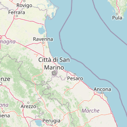
Located in Italy, the park extends across Tuscany, Emilia-Romagna, and the Forlì-Cesena Province. Geographic records classify the park as an inland, non-coastal protected area with no transboundary borders.
- Countries
- Italy
- Regions
- Emilia-Romagna, Forlì-Cesena Province, Tuscany
- Primary location
- Forlì-Cesena Province
- Geographic setting
- Inland
Boundary and coordinates
Footprint and spatial limits of a 368 square kilometer reserve
Map and Boundaries of Foreste Casentinesi, Monte Falterona, Campigna National Park
Interactive geographic boundaries trace the physical outline and regional positioning of the park. Accompanying spatial metrics outline the 368 square kilometer terrestrial extent and coordinate limits.
- Boundary area
- 368.3 km²
- Boundary perimeter
- 189 km
- Northernmost point
- 44.0404° N
- Southernmost point
- 43.6995° N
- Easternmost point
- 11.9566° E
- Westernmost point
- 11.6164° E
- Geographic centre
- 43.867° N, 11.7793° E
- North–south span
- 37.9 km
- East–west span
- 27.3 km
Elevation and terrain
Mountain relief summary and recorded physical features
Foreste Casentinesi, Monte Falterona, Campigna National Park Terrain and Elevation
Recorded elevation metrics span from four hundred meters to one thousand six hundred fifty eight meters across mountain terrain. Mapped feature cards display names, types, and spatial relationships for interior streams, peaks, and springs.
- Minimum elevation
- 400 m
- Maximum elevation
- 1,658 m
- Highest point
- 1,658 m
Selected named natural features
Streams
Fosso del Paretaio
Streams
Fosso di Rio Salso
Peaks
Sasso alla Croce
Peaks
Poggio Sodo dei Conti
1,559 m
Streams
Fosso della Lama
Environmental setting
Temperate climate zones, forest cover types, and mountain relief profiles
Foreste Casentinesi, Monte Falterona, Campigna National Park Environmental Settings
Recorded landscape features, habitat types, and relief classifications form complementary interpretations of the physical setting across Foreste Casentinesi, Monte Falterona, Campigna National Park. Connected category links direct exploration toward related protected areas sharing similar environmental classifications within the atlas.
- Relief
- Mountain
- Climate
- Temperate
- Water
- Minor water
- Forest cover
- Mostly forested
- Seasonality
- Year-round
Landscape features
Mountains · Forest · Valleys · Rivers · Waterfalls · Cliffs
Habitat types
Temperate broadleaf forest · Montane forest · Riverine habitat · Wetland
Park atlas
Compare surrounding protected landscapes across the Apennine Mountains and Forlì-Cesena Province
Discover More National Parks and Protected Areas near Foreste Casentinesi, Monte Falterona, Campigna National Park
Explore a curated list of national parks and protected areas geographically proximate to Foreste Casentinesi, Monte Falterona, Campigna National Park, expanding your view beyond its ancient beech forests and Apennine ridges. This geographic context helps compare diverse conservation landscapes, tracing the regional spread of protected zones across Emilia-Romagna and Tuscany for comprehensive atlas discovery.
Nature reserveEmilia-Romagna
About 59 km away#1 closest
North

Riserva naturale speciale di Alfonsine: Protected Wetlands and Forest Oases
Regional nature reserve in the Emilia-Romagna lowlands
This reserve comprises three separate oases that protect remnants of rare lowland wetlands. Featuring a mixture of marshy pond basins, canal corridors, and flooded forests, the site provides a sanctuary for waterbirds and the European pond terrapin. The area represents a focused effort to conserve aquatic habitats and riparian woodlands nestled within the wider agricultural plains of northern Italy.
- Area
- 0.12 km²
- Established
- 1990
National parkEmilia-Romagna
95 km away#2 closest
Northwest
Appennino Tosco-Emiliano National Park: Explore Its National Park Boundaries and Geography
Discover the mapped landscape and regional context of this protected area.
Appennino Tosco-Emiliano National Park is a designated national park offering a rich area for geographic exploration. This MoriAtlas entry details the park's protected landscape, providing insights into its mapped boundaries and its contribution to the natural terrain of the Emilia-Romagna region. Understand its significance within the broader atlas of Italian protected areas, focusing on its unique geographic identity and landscape context.
- Area
- 227.92 km²
- Established
- 2001
- IUCN
- II
- Relief
- Mountain
Biosphere reserveEmilia-Romagna
About 107 km away#3 closest
Northwest
Carsismo e grotte evaporitiche dell'Appennino settentrionale Protected Geological Reserve
Evaporite karst landscapes within the Emilia-Romagna region.
Spanning across northern Italy, this site features a dense concentration of gypsum caves and sculpted karst terrain. It stands as a premier example of evaporite geomorphology, with record-breaking cave depths and diverse formations that offer a deep look into the geological history of the northern Apennines.
- Established
- 2023
- Relief
- Mountain
- Scope
- Terrestrial
- Water
- Minor water
Marine protected areaFrance
109 km away#4 closest
West

Sanctuaire Pelagos Marine Protected Area: Mediterranean Geography and Seascape
A transboundary conservation zone spanning 87,500 square kilometers.
Sanctuaire Pelagos represents a unique collaborative effort in marine conservation across the Mediterranean. Spanning the waters between France, Italy, and Monaco, this protected maritime area is defined by its deep-sea canyons and nutrient-rich currents that sustain diverse cetacean populations. Its immense scale and international governance make it a focal point for understanding Mediterranean marine biodiversity and environmental policy.
- Area
- 87,500 km²
- Established
- 1999
- IUCN
- IV
- Relief
- Lowland
National parkMarche
117 km away#5 closest
Southeast
Monti Sibillini National Park: National Park with Regional Geographic Context in Marche
Explore protected landscape boundaries and terrain.
Monti Sibillini National Park serves as a vital national park within the Marche region, offering a distinct natural landscape for geographic study. This entry provides essential context for understanding the park's mapped protected area status and its integration into the regional geography of central Italy. Delve into the park's specific setting, discovering how its terrain and protected status contribute to the atlas of Italian natural landscapes.
- Area
- 697.22 km²
- Established
- 1993
- IUCN
- II
- Relief
- Mountain
Nature reserveUmbria
About 122 km away#6 closest
South
Oasi naturalistica Lago di Alviano: Protected Wetland Landscapes and River Geography
A vital nature reserve in the Tiber Valley region of Umbria
Discover the unique wetland geography of Oasi naturalistica Lago di Alviano, where marshy river basins meet extensive hygrophilous forest corridors. This reserve serves as a critical node in central Italy for migratory waterbird habitats, showcasing the natural transition between riparian woodland and shallow aquatic ecosystems within the broader Tiber Valley protected network.
- Area
- 9 km²
- Established
- 1990
- Scope
- Terrestrial
- Water
- Major water bodies
Nature reserveEmilia-Romagna
140 km away#7 closest
Northwest
Monte Prinzera Nature Reserve: Emilia-Romagna Protected Ophiolite and Geological Atlas
Ancient oceanic crust and rare ecological habitats
Monte Prinzera represents a singular geological anomaly in the Apennine foothills, characterized by its deep rust-red color and specialized dry Mediterranean vegetation. As the only protected ophiolite site in Emilia-Romagna, the reserve offers essential insight into ultramafic ecology, hosting a mosaic of mixed deciduous woodlands and xerophilous grasslands that support unique populations of birds, bats, and mammals.
- Established
- 1990
- Relief
- Mountain
- Scope
- Terrestrial
- Water
- Minor water
National parkTuscany
141 km away#8 closest
Southwest
Arcipelago Toscano National Park: Protected Islands and Mediterranean Landscape Atlas
Explore Tuscany's unique archipelago geography and protected natural terrain.
Arcipelago Toscano National Park offers a unique perspective on Mediterranean island ecosystems through its comprehensive atlas and mapped landscape context. Covering seven main islands and surrounding marine areas off the coast of Tuscany, this park protects dramatic granite cliffs, endemic flora, and vital habitats for marine and avian life. Understand its geographic scope, protected boundaries, and the distinctive natural terrain that defines this significant Italian conservation landscape.
- Area
- 746.63 km²
- Established
- 1996
- IUCN
- II
- Relief
- Mixed relief
MoriAtlas Explorer
Continue Exploring Foreste Casentinesi, Monte Falterona, Campigna National Park's Geographic Context
Deepen your understanding of Foreste Casentinesi, Monte Falterona, Campigna National Park by examining its precise geographic setting and mapped protected area boundaries within Forlì-Cesena Province. MoriAtlas provides structured data for navigating Italy's diverse protected landscapes and understanding their regional distribution, offering a unique lens for exploring natural terrain and conservation areas.
Browse next
Global natural geography
Explore related park routes
Explore MoriAtlas Global ParksBrowse All MoriAtlas ParksGlobal Park Map DiscoveryMoriAtlas: Browse All CountriesBrowse All MoriAtlas ContinentsNational Park Environment AtlasGrand Canyon National Park AtlasYellowstone National Park AtlasYosemite National Park Atlas and GeographySerengeti National Park AtlasGalápagos National Park Protected LandscapeBanff National Park Geography and AtlasKruger National Park Atlas EntryUluṟu-Kata Tjuṯa National Park AtlasExplore Uluru-Kata Tjuta National Park GeographyPlitvice Lakes National Park AtlasFiordland National Park Protected LandscapeGreat Smoky Mountains National Park AtlasAfghanistan National Parks and Protected AreasAlbania National Parks and Protected AreasAlgeria National Parks and Protected AreasAmerican Samoa National Parks and Protected AreasAndorra National Parks and Protected AreasAngola National Parks and Protected AreasAntarctica National Parks and Protected AreasAntigua and Barbuda Park List