

Mori Atlas logo
National parkFrank Hann National Park

Detailed mapped boundaries and regional landscape context for this national park.

Frank Hann National Park: Protected Landscape Identity and Geographic Context in Western Australia

Frank Hann National Park stands as a significant protected natural area within the vast geography of Western Australia. This dedicated national park offers a unique focus for understanding mapped protected landscapes and their regional settings. Explore its specific geographic boundaries and discover how it contributes to the atlas of conservation areas in this expansive Australian state.

Heathland ReserveWestern AustraliaSemi-arid WildernessMallee EcosystemsWildflower DisplaysRemote National Park

Frank Hann National Park

National park

Park overview

Structured park overview, official facts, and landscape profile for Frank Hann National Park

Frank Hann National Park park facts, protected area profile, and essential visitor context
Review the core facts for Frank Hann National Park, including designation, size, terrain, visitor scale, habitats, and operating context in one park-focused overview.

About Frank Hann National Park

Frank Hann National Park represents one of Western Australia's significant protected areas in the southern wheatbelt, preserving a substantial tract of inland sandplain heathland and mallee ecosystems that have been largely cleared for agriculture elsewhere in the region. Located near the small community of Lake King, the park occupies a remote position in the state's agricultural heartland, offering visitors an opportunity to experience landscapes that remain relatively untouched by development. The reserve's name honours Frank Hann, an early explorer who contributed to the mapping and understanding of this part of Western Australia during the late nineteenth and early twentieth centuries. The park's establishment in 1970 reflected growing recognition of the ecological importance of mallee and heathland communities, which support specialized flora and fauna adapted to the region's low rainfall and nutrient-poor soils. While the park lacks visitor facilities, this absence contributes to a sense of wilderness and self-sufficiency that appeals to experienced bushwalkers and nature enthusiasts seeking to explore Australia's inland environments without the infrastructure found in more heavily visited reserves.

Quick facts and research context for Frank Hann National Park

Frank Hann National Park occupies 675.5 square kilometres of semi-arid heathland and scrubland in southern Western Australia's wheatbelt. The park lies within the Eastern Mallee IBRA subregion, approximately 428 kilometres east-southeast of Perth near Lake King. Established on 30 October 1970, the park was named after explorer Frank Hann and is managed by the Department of Parks and Wildlife. The inland sandplain terrain supports diverse flora including multiple Acacia species and Banksia xylothemelia, with seasonal wildflower displays. No visitor facilities are available and no entrance fee is charged.

Park context

Deeper park guide and search-rich context for Frank Hann National Park

Frank Hann National Park history, landscape, wildlife, and travel context
Explore Frank Hann National Park through its history, landscape character, ecosystems, wildlife, conservation priorities, cultural context, and seasonal travel timing in a structured park guide built for atlas discovery and search intent.

Why Frank Hann National Park stands out

Frank Hann National Park is best known for its extensive heathland and scrubland ecosystems on the inland sandplain, which support remarkable plant and animal diversity despite the semi-arid environment. The park protects significant populations of mallee woodland and heath plant communities, with seasonal wildflower displays that transform the landscape. It provides crucial habitat for diverse reptile communities including multiple gecko and skink species, while mammal populations include the western quoll, honey possum, and Mitchell's hopping mouse. The birdlife is particularly notable, with emus, birds of prey including kestrels and falcons, and ground-dwelling species like the Australian bustard all present within the reserve.

Frank Hann National Park history and protected-area timeline

Frank Hann National Park was officially established on 30 October 1970, named in honour of Frank Hann, an early explorer who played a significant role in surveying and documenting the landscapes of the Lake Grace region during the early twentieth century. The park's creation reflected broader conservation movements in Western Australia during the 1960s and 1970s, a period when multiple protected areas were declared to preserve representative samples of the state's diverse ecosystems. The Eastern Mallee region had been subject to agricultural development throughout the twentieth century, making the establishment of this reserve particularly important for preserving the remaining intact heathland and mallee communities. The Department of Parks and Wildlife assumed management responsibility for the reserve, continuing to oversee its conservation values while allowing public access for compatible recreational use.

Frank Hann National Park landscape and geographic character

The landscape of Frank Hann National Park is characterized by extensive heathland and scrubland extending across the inland sandplain of southern Western Australia. The terrain is predominantly flat to gently undulating, with the underlying sandplain creating well-drained soils that support characteristic heath vegetation communities. The landscape lacks significant topographic variation, instead presenting a broad, open environment where low-growing woody and herbaceous plants dominate. Seasonal changes bring visual transformation as wildflowers bloom across the heathland, adding colour to what is otherwise a predominantly grey-green and brown palette. The Lilian Stokes Rockpools represent one of the more notable geological features within the park, providing ephemeral water features that add ecological and aesthetic interest to the otherwise uniform sandplain terrain.

Frank Hann National Park ecosystems, habitats, and plant life

The nature of Frank Hann National Park centers on its representation of Eastern Mallee bioregion ecosystems, characterized by extensive heathland and scrubland communities adapted to the semi-arid conditions of Western Australia's wheatbelt. The inland sandplain soils are typically low in nutrients, selecting for plant species that have evolved specialized adaptations to survive in these challenging conditions. The park supports significant botanical diversity including multiple Acacia species such as Acacia mackeyana and Acacia dissona, along with Banksia xylothemelia. The seasonal wildflower displays represent a particular highlight, with various herbaceous species responding to winter rainfall to produce carpeted displays across the heathland. These plant communities provide the foundation for the park's ecological complexity, supporting the diverse animal life that inhabits the reserve.

Frank Hann National Park wildlife and species highlights

Frank Hann National Park supports a notable array of wildlife despite its semi-arid setting, with reptile diversity being particularly pronounced. The park provides habitat for multiple lizard species including the marbled gecko, clawless gecko, crested dragon, callose-palmed shining-skink, and bright crevice skink. Amphibian populations are well-represented, with species such as Myobatrachus gouldii, Pseudophryne guentheri, and Limnodynastes dorsalis occupying the moisture-retaining microhabitats within the park. Birdlife is diverse and includes emus, birds of prey such as Nankeen kestrel, brown falcon, and little eagle, ground-dwelling species like the crested pigeon, brush bronzewing, mulga parrot, and Australian bustard. Mammal inhabitants include short-beaked echidna, western quoll, Gilbert's dunnart, honey possum, western grey kangaroo, western brush wallaby, Gould's wattled bat, and Mitchell's hopping mouse, representing a good cross-section of southern Australian arid-zone fauna.

Frank Hann National Park conservation status and protection priorities

Frank Hann National Park plays an important conservation role in preserving the remaining intact heathland and mallee ecosystems of the Eastern Mallee bioregion, an area that has been extensively cleared for broadacre agriculture. The park protects vegetation communities that would otherwise exist only in fragmented remnants across the wheatbelt, providing connectivity and refuge for native species adapted to these habitats. The diversity of reptiles, mammals, and birds recorded within the park demonstrates its ecological significance, supporting populations of species that have declined across much of the surrounding agricultural landscape. Conservation management focuses on maintaining the park's natural values while allowing compatible public enjoyment, with the absence of introduced visitor infrastructure helping to minimize environmental impact on this relatively unmodified landscape.

Frank Hann National Park cultural meaning and human context

The park is named after Frank Hann, an early explorer who contributed to the historical understanding and mapping of the Lake Grace region in Western Australia's interior. Hann's exploration during the early twentieth century helped identify the potential of this area for pastoral and agricultural development, ultimately leading to the establishment of the wheatbelt farming communities that now surround the park. The broader region has indigenous heritage values though the Wikipedia source does not detail specific indigenous associations with the park itself. The landscape has been shaped by Aboriginal land management over thousands of years, though the semi-arid inland sandplain environment would have supported relatively low population densities compared to more fertile areas.

Top sights and standout views in Frank Hann National Park

The extensive heathland and scrubland landscapes of Frank Hann National Park offer a distinctive semi-arid wilderness experience in southern Western Australia. Seasonal wildflower displays transform the park during favorable seasons, while the diverse reptile and mammal populations provide wildlife observation opportunities for patient observers. The park's significant size at 675.5 square kilometres ensures a sense of remoteness and emptiness that appeals to visitors seeking uncrowded natural environments. The presence of multiple bird of prey species including Nankeen kestrels, brown falcons, and little eagles demonstrates the ecological health of the heathland food web, while the honey possum represents an unusual marsupial species adapted to feeding on nectar. The Lilian Stokes Rockpools offer a focal point for exploration within the otherwise uniform sandplain terrain.

Best time to visit Frank Hann National Park

The best time to visit Frank Hann National Park is during the cooler months of autumn and spring when temperatures are more comfortable for outdoor exploration. Winter and early spring typically bring the wildflower season, with rainfall triggering flowering across the heathland and creating more visually appealing landscape conditions. Summer temperatures in the wheatbelt can be extremely high, making outdoor activity uncomfortable and increasing fire risk. Visitors should note that the park has no facilities, requiring self-sufficiency and careful planning including adequate water supplies and appropriate vehicles for accessing the remote location. The lack of entrance fees and visitor infrastructure means that the park attracts those comfortable with dispersed, undeveloped outdoor experiences.
Park location guide

Geography guide, regional context, and park location map for Frank Hann National Park

Frank Hann National Park park geography, regions, and map view in Australia
Understand where Frank Hann National Park sits in Australia through a broader geographic reading of the surrounding landscape, nearby location context, and its mapped position within the national park landscape.

How Frank Hann National Park fits into Australia

Australia is a constitutional monarchy and federal parliamentary democracy comprising six states and ten territories. With a population of nearly 28 million, it is one of the world's most urbanised countries, with most people concentrated on the eastern seaboard. The country has a high Human Development Index and is known for its cultural diversity, ancient Aboriginal heritage, and unique wildlife.

Wider geography shaping Frank Hann National Park in Australia

Australia occupies the entire Australian continent, the island of Tasmania, and numerous smaller islands. It is the world's flattest and driest inhabited continent, featuring vast deserts in the interior (the Outback), tropical rainforests along the eastern coast, and a coastline bordering the Indian and Pacific Oceans.

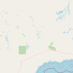
Map view of Frank Hann National Park

Use this park location map to pinpoint Frank Hann National Park in Australia, understand its exact geographic position, and read its mapped placement within the surrounding landscape more clearly.

Pigeon | © OpenStreetMap contributors

Location context for Frank Hann National Park

Western Australia
Park atlas

Explore the geographic spread of protected areas, comparing Frank Hann National Park with nearby Western Australian landscapes.

Discover Other National Parks and Protected Areas Near Frank Hann National Park, Western Australia
After exploring Frank Hann National Park, continue your discovery by browsing other protected areas within Western Australia's semi-arid interior and the Eastern Mallee bioregion. This expanded view allows you to compare diverse heathland ecosystems, understand regional conservation efforts, and map the spread of similar wilderness landscapes, providing valuable geographic context.
National parkWestern Australia

Peak Charles National Park: A National Park in Western Australia's Mapped Landscape

Discover its protected area status and geographic setting.

Peak Charles National Park is a vital component of Western Australia's protected natural areas. This dedicated page provides an atlas-centric view, focusing on the park's geographic scope, its mapped boundaries, and the surrounding regional landscape context. It serves as an essential resource for understanding the park's protected land identity and its contribution to the broader geography of Western Australia.

Area
399.59 km²
Established
1979
IUCN
II
Relief
Mountain
Watercolor illustration showing mountains in the background, green vegetation, and pink meadows
National parkWestern Australia

Fitzgerald River National Park: A Western Australian Protected Landscape of Global Botanical Importance

Discover its mapped terrain, endemic flora, and UNESCO Biosphere Reserve status.

Fitzgerald River National Park stands as a protected landscape of immense ecological value in Western Australia. This national park is celebrated for its extraordinary botanical diversity, featuring more endemic plant species than any other conservation reserve in Australia. Its varied terrain, from rugged mountain ranges to coastal cliffs, provides a rich tapestry of natural habitats. As a designated UNESCO Biosphere Reserve, it offers a unique opportunity to explore mapped geographic features and understand the critical role of protected areas in conserving rare flora and distinct Mediterranean ecosystems.

Area
2,972.11 km²
Established
1973
IUCN
II
Visitors
40K annual
National parkWestern Australia

Stokes National Park National Park: Mapped Boundaries and Regional Geography

Western Australia's protected landscape identity.

Stokes National Park represents a significant protected entity within the expansive geography of Western Australia. This detailed page provides users with essential mapping information, focusing on the park's designated boundaries and its role within the broader atlas of Australian conservation landscapes. Explore the specific geographic context that defines this national park and understand its natural landscape features.

Area
97.26 km²
Established
1976
IUCN
II
Relief
Lowland
National parkWestern Australia

Boorabbin National Park: Exploring Western Australia's National Park Landscape and Boundaries

Mapped protected area context within Western Australia's geography.

Boorabbin National Park represents a distinct protected landscape within the expansive geography of Western Australia. This entry provides focused insight into the park's identity as a national park, highlighting its specific mapped boundaries and its contribution to the regional atlas of protected areas. Understanding Boorabbin National Park's geographic setting allows for a deeper appreciation of Western Australia's natural terrain and conservation efforts.

Area
281.53 km²
Established
1977
IUCN
II
Relief
Upland
National parkGoldfields-Esperance

Goldfields Woodlands National Park: Explore Protected Area Geography and Mapped Boundaries

Discover the mapped landscape context of this national park.

Delve into Goldfields Woodlands National Park, a key protected area within the Goldfields-Esperance region. This resource provides detailed atlas-style information, focusing on the park's mapped geography, its protected status, and its role within the broader regional landscape. Understand its specific topographic features and its place in the natural atlas.

Area
646.28 km²
Established
2000
Climate
Arid
Scope
Terrestrial
National parkWestern Australia

Cape Le Grand National Park: Western Australia National Park Geographic Context and Landscape Exploration

Mapped protected area boundaries and regional natural terrain discovery.

Cape Le Grand National Park is an important national park in Western Australia, providing a distinct focus for geographic and atlas-based discovery. Understanding its protected landscape identity and its placement within the state's natural geography offers valuable insight into regional conservation areas. This page serves as a canonical entry point for exploring the mapped features and the broader geographic significance of Cape Le Grand National Park, detailed for structured atlas exploration.

Area
318.01 km²
Established
1966
IUCN
II
Relief
Mixed relief
National parkWestern Australia

Hassell National Park National Park: Mapped Protected Landscape in Western Australia

Explore the geographic identity and park boundaries of Hassell National Park.

Hassell National Park offers a focused view of protected natural landscapes within Western Australia. This atlas entry details the park's specific geographic scope and its designation as a national park, providing essential context for understanding its mapped features and regional landscape. Explore how Hassell National Park contributes to the protected area geography of the state.

Area
12.65 km²
Established
1971
IUCN
II
Scope
Mixed
National parkWestern Australia

Waychinicup National Park: National Park Protected Landscape Atlas Entry

Explore Western Australia's mapped natural landscapes and park geography.

Gain a structured understanding of Waychinicup National Park as a key protected landscape within Western Australia. This detailed atlas entry focuses on its geographic distribution and mapped boundaries, providing essential context for regional park and natural landscape exploration. Discover the unique characteristics of this national park's setting and its place within the broader mapped terrain.

Area
39.82 km²
Established
1990
IUCN
II
Relief
Mixed relief

Common questions about visiting, size, designation, and location context for Frank Hann National Park

Frank Hann National Park FAQs for park facts, access, geography, and protected area context
Find quick answers about Frank Hann National Park, including protected-area facts, park geography, trail and visitor context, and how the park fits into its surrounding country and regional landscape.
MoriAtlas Explorer

Continue Your Protected Areas Search Across the Global Atlas

Deepen your exploration by continuing the structured search for national parks and protected areas worldwide. Utilize the comprehensive filtering capabilities to compare different conservation landscapes and refine your understanding of global park geography. Discover more about the distribution and characteristics of protected natural areas.

Global natural geography