

Mori Atlas logo
National parkGayasan National Park

Explore the mapped boundaries and regional geography of this national park in South Korea.

Gayasan National Park: South Gyeongsang Province's Protected Landscape and Natural Terrain

Gayasan National Park stands as a significant protected area within South Gyeongsang Province, offering a unique focus for geographic discovery. This page delves into the park's identity as a national park, highlighting its mapped geographic features and position within the regional atlas. Users can investigate the natural terrain and protected land boundaries that define Gayasan National Park, providing essential context for understanding its place in South Korea's conservation landscape.

Mountain parksBuddhist heritage sitesSouth Korea national parksHiking trailsForest ecosystemsWaterfalls

Gayasan National Park

National park

Park overview

Structured park overview, official facts, and landscape profile for Gayasan National Park

Gayasan National Park park facts, protected area profile, and essential visitor context
Review the core facts for Gayasan National Park, including designation, size, terrain, visitor scale, habitats, and operating context in one park-focused overview.

About Gayasan National Park

Gayasan National Park occupies a significant position among South Korea's twenty-two national parks, protecting a landscape that seamlessly blends natural beauty with centuries of Buddhist tradition. The park's location along the Sobaek Mountain range places it at a geographic crossroads between two provinces, creating a montane environment characterized by steep ridges, forested slopes, and hidden valleys. The mountain's two principal peaks, Sangwangbong and Chulbulbong, form the visual centerpiece of the park and are popular destinations for hikers seeking panoramic views of the surrounding countryside. Beyond the mountain summits, the park contains the Yongmun Falls and Hongnyudong Valley, areas of particular ecological richness where diverse plant communities thrive in the moist, shaded environment created by the falls and forest canopy. Haeinsa temple, founded in the early 9th century and rebuilt following destruction during the Japanese invasions, remains an active center of Buddhist practice and a monument of extraordinary architectural and cultural significance. The temple's grounds contain a standing Buddha figure carved into vertical rock, a unique feature that distinguishes this sacred site within the Korean Buddhist tradition.

Quick facts and research context for Gayasan National Park

Gayasan National Park covers over 160 square kilometers along the Sobaek Mountain range in eastern South Korea. The park straddles the border between North and South Gyeongsang provinces, with the nearest major city being Daegu. Established as a national park in 1972, the area had previously been designated Scenic Site No. 5 in 1966. The park features two primary peaks, Sangwangbong and Chulbulbong, and contains the renowned Haeinsa Buddhist temple complex. Yongmun Falls and Hongnyudong Valley support remarkable biodiversity, with 380 plant species and 100 bird species recorded in the valley alone. The Korea National Park Service manages the protected area, which offers multiple hiking trails and three designated campgrounds.

Park context

Deeper park guide and search-rich context for Gayasan National Park

Gayasan National Park history, landscape, wildlife, and travel context
Explore Gayasan National Park through its history, landscape character, ecosystems, wildlife, conservation priorities, cultural context, and seasonal travel timing in a structured park guide built for atlas discovery and search intent.

Why Gayasan National Park stands out

Gayasan National Park is best known for its dual identity as both a natural mountain sanctuary and a profound religious site. The park's namesake mountain, Gaya, is revered for its spiritual significance and features two dramatic peaks that attract hikers and climbers throughout the year. Haeinsa temple, one of the Three Great Temples of Korean Buddhism, anchors the park's cultural significance and houses important Buddhist relics within its historic grounds. The legend that the Gaya Mountain region remains protected from the Three Disasters of fire, floods, and wind adds a layer of traditional belief that has persisted since the Japanese invasions of 1592-98, when the area's remoteness helped preserve it from destruction.

Gayasan National Park history and protected-area timeline

The area that now comprises Gayasan National Park received formal recognition as Scenic Site No. 5 by the Korean government in 1966, acknowledging both its natural beauty and cultural importance. This designation preceded the park's official establishment as a national park on October 13, 1972, when the Korea National Park Service assumed management responsibilities for the area. The region's history extends far deeper than these modern designations, however, as evidenced by the presence of Haeinsa temple, which has drawn pilgrims and scholars for centuries. The relative remoteness of the Gayasan region played a crucial role in its preservation, particularly during the Japanese invasions of Korea from 1592 to 1598, when much of the Korean peninsula suffered widespread destruction. Local legend maintains that the area around Gaya Mountain has remained protected from the Three Disasters of fire, floods, and wind since that turbulent period, a belief that reflects the region's enduring reputation as a place of safety and spiritual refuge.

Gayasan National Park landscape and geographic character

The physical landscape of Gayasan National Park is defined by the rugged terrain of the Sobaek Mountain range, which runs north-south through the eastern part of the Korean peninsula. The park encompasses the twin peaks of Sangwangbong and Chulbulbong, with Chulbulbong reaching 1,433 meters as the higher of the two summits. These steep, forested peaks rise dramatically from the surrounding valleys, creating a landscape of deep ravines, rocky ridges, and cascading streams. The Yongmun Falls represents one of the most striking hydrological features, where water drops through a rocky gorge into the valley below. Hongnyudong Valley provides another important landscape feature, offering a relatively gentle valley environment where moisture collects and supports lush vegetation. The forest cover varies with elevation, transitioning from deciduous broadleaf forests in the lower reaches to mixed forests as altitude increases.

Gayasan National Park ecosystems, habitats, and plant life

The ecological character of Gayasan National Park reflects the interplay between its montane environment and the moisture-rich conditions created by its forested valleys and waterfalls. The Hongnyudong Valley area alone has been documented to support 380 different plant species, indicating the ecological richness found throughout the park's protected boundaries. This botanical diversity includes various tree species, ferns, and understory plants adapted to the shaded conditions beneath the forest canopy. The park's elevation range and location within the Sobaek Mountain range create diverse microhabitats that support different plant communities across relatively short distances. Birds play a particularly notable role in the park's wildlife, with over 100 species recorded within the valley areas, making Gayasan an important area for avian biodiversity within the region. The protected status of the park helps maintain these ecological communities against pressures from surrounding agricultural and urban development.

Gayasan National Park wildlife and species highlights

The wildlife population within Gayasan National Park benefits from the protection afforded to its diverse habitats across the montane environment. Birdlife represents one of the most documented aspects of the park's fauna, with more than 100 species identified in the valley areas alone, reflecting the importance of the forested slopes and riparian corridors as bird habitat. The diverse plant communities documented in the park support corresponding invertebrate populations and provide food sources for larger animals. While the source material does not provide detailed accounts of specific mammal or reptile species, the presence of varied forest types, rock outcrops, and water features suggests the park supports a range of vertebrate species typical of Korean mountain ecosystems. The Yongmun Falls and surrounding wetland areas likely provide particularly important habitat for species associated with riparian and aquatic environments.

Gayasan National Park conservation status and protection priorities

Gayasan National Park represents an important conservation asset within South Korea's protected areas network, preserving both significant natural habitats and irreplaceable cultural heritage within a single protected boundary. The park's designation as a Category II protected area under IUCN classification reflects its primary function as a national park dedicated to ecosystem conservation while allowing for sustainable recreation and cultural use. The protection of the Sobaek Mountain range habitat helps preserve biodiversity within a region that has experienced substantial development pressure. The presence of Haeinsa temple within park boundaries creates a unique conservation challenge, as the protection of historic religious structures must be balanced with natural resource management. The Korean National Park Service manages the park according to broader national park management principles that integrate conservation, public enjoyment, and cultural preservation.

Gayasan National Park cultural meaning and human context

The cultural significance of Gayasan National Park extends far beyond its natural features, rooted primarily in the presence of Haeinsa temple, one of the most important Buddhist establishments in Korea. Founded in the early 9th century, Haeinsa has been a center of Buddhist learning and practice for over a millennium, surviving destruction during the Japanese invasions of the late 16th century and being rebuilt as a testament to the resilience of Korean Buddhist tradition. The temple houses important scriptures and artifacts, and its unique standing Buddha carved into vertical rock represents a distinctive feature within Korean religious art. The legend of Gaya Mountain's protection from the Three Disasters of fire, floods, and wind reflects traditional beliefs about the spiritual protective qualities of the landscape. This intertwining of natural landscape and religious significance has shaped human engagement with the Gayasan region for centuries, making it both a destination for pilgrimage and a symbol of cultural preservation.

Top sights and standout views in Gayasan National Park

The distinctive character of Gayasan National Park derives from the remarkable combination of natural mountain landscapes and living Buddhist heritage within a single protected area. The twin peaks of Sangwangbong and Chulbulbong offer challenging hiking opportunities and sweeping views across the Sobaek range, while the ancient forest trails leading to Haeinsa temple provide a pathway through both natural and cultural history. Yongmun Falls and the botanical richness of Hongnyudong Valley showcase the park's ecological diversity, with documented plant and bird species highlighting the biological importance of these protected habitats. The legend of freedom from the Three Disasters adds a layer of traditional belief that connects the landscape to centuries of Korean cultural history. The three designated campgrounds within the park provide opportunities for extended exploration of this mountain sanctuary.

Best time to visit Gayasan National Park

Gayasan National Park can be visited throughout the year, though spring and autumn are generally considered the most rewarding seasons for experiencing the park's character. Spring brings new growth to the deciduous forests and pleasant temperatures for hiking, while autumn displays the characteristic colors of changing leaves across the mountain slopes. Summer months offer the opportunity to see the waterfalls at their fullest flow following the rainy season, though visitors should be prepared for higher temperatures and humidity in the valley areas. Winter snow can transform the mountain peaks into a dramatic winter landscape, though trail conditions may become more challenging at higher elevations. The timing of visits may also be influenced by the desire to experience Haeinsa temple during Buddhist holidays or festivals, when the temple complex takes on particular vibrancy.

Park location guide

Geography guide, regional context, and park location map for Gayasan National Park

Gayasan National Park park geography, regions, and map view in South Korea
Understand where Gayasan National Park sits in South Korea through a broader geographic reading of the surrounding landscape, nearby location context, and its mapped position within the national park landscape.

How Gayasan National Park fits into South Korea

South Korea is a presidential republic on the Korean Peninsula in East Asia. It has a population of about 51 million and Seoul as its capital and largest city. The country is known for its rapid economic development, high technology industry, and cultural exports.

Wider geography shaping Gayasan National Park in South Korea

South Korea occupies the southern half of the Korean Peninsula in East Asia. It borders North Korea along the Demilitarized Zone to the north, the Yellow Sea to the west, and the Sea of Japan to the east. The terrain is predominantly mountainous with coastal plains along the southern and eastern shores.

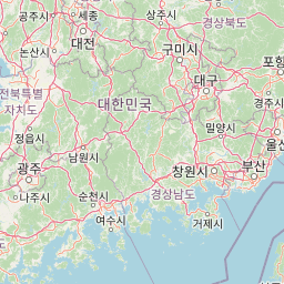
Map view of Gayasan National Park

Use this park location map to pinpoint Gayasan National Park in South Korea, understand its exact geographic position, and read its mapped placement within the surrounding landscape more clearly.

Pigeon | © OpenStreetMap contributors

Location context for Gayasan National Park

South Gyeongsang Province
Park atlas

Explore the Surrounding Mountain Landscapes and Cultural Protected Areas in the Korean Peninsula

Discover More Protected Areas and National Parks Near Gayasan National Park, South Korea
Continue your protected area exploration beyond Gayasan National Park by browsing adjacent mountain landscapes and culturally significant sites across South Korea. Compare the diverse terrain, forest ecosystems, and sacred Buddhist heritage that define this region's impressive network of national parks and conservation areas.
National parkJeollabuk-do

Deogyusan National Park: National Park Identity and Geographic Mapping

Explore its protected land boundaries and regional landscape context.

Examine Deogyusan National Park, a designated national park situated in the Jeollabuk-do region of South Korea. This entry provides critical geographic context, focusing on the park's mapped boundaries and its role as a protected landscape. Users can gain a structured understanding of its natural terrain and regional significance, contributing to a broader atlas of protected areas.

Area
231.65 km²
Established
1975
IUCN
V
Visitors
1M annual
National parkSouth Korea

Jirisan National Park: South Korea's Premier Protected Landscape and Map Resource

Explore the mapped terrain and protected area geography.

Jirisan National Park is a key protected area within South Korea, serving as a vital component of the nation's natural landscape. This atlas-focused content provides detailed geographic information, highlighting the park's mapped boundaries and its role within the regional context of the Korean Peninsula. Understand the distinct characteristics of this protected national park for comprehensive geographic discovery.

Area
471.75 km²
Established
1967
IUCN
II
Visitors
1.5M annual
National parkSouth Korea

Songnisan National Park: Mapped Protected Landscape and Geographic Context in South Korea

Discover South Korea's Songnisan National Park and its protected terrain.

Delve into the protected landscape of Songnisan National Park, a key national park entity in South Korea. This atlas-focused view highlights its mapped geographic boundaries and natural terrain, providing essential context for understanding conservation areas. Explore Songnisan National Park as a distinct protected region contributing to the country's diverse geography and mapped natural heritage.

Area
274.541 km²
Established
1970
IUCN
II
Relief
Mountain
National parkNorth Gyeongsang Province

Gyeongju National Park: National Park Protected Landscape in North Gyeongsang Province

Mapped boundaries and regional geographic context.

Gyeongju National Park serves as a significant protected area within North Gyeongsang Province, offering a distinct national park identity. This entry focuses on its geographical significance, detailing its mapped boundaries and providing essential context for atlas exploration. Understand how this protected landscape fits within the broader regional geography and discover its place in the structured mapping of South Korea's natural heritage.

Area
137.09 km²
Established
1968
IUCN
II
Relief
Mixed relief
National parkChungcheongnam-do

Gyeryongsan National Park: Mapped Protected Landscape in Chungcheongnam-do

Explore its national park designation and regional geography.

Gyeryongsan National Park is a formally protected national park in Chungcheongnam-do, South Korea. This page offers critical atlas context for understanding the park's geographic scope, mapped protected boundaries, and its significance as a natural landscape within the region. Examine the terrain and explore its regional context for a deeper appreciation of its protected status.

Area
64.71 km²
Established
1968
IUCN
II
Relief
Mountain
Watercolor illustration of green hills, a body of water, and mountain peaks under a soft sky
National parkGyeongsangbuk-do

Woraksan National Park: A Key National Park in Gyeongsangbuk-do's Regional Geography

Discover its mapped mountain terrain and protected landscape identity.

Woraksan National Park offers a detailed view of protected mountain landscapes within South Korea's Gyeongsangbuk-do region. The park is characterized by its prominent Mount Worak, steep ridgelines, and dense forested terrain, contributing significantly to the nation's network of protected areas. Users can explore the geographic context, mapped boundaries, and ecological significance of this vital national park, understanding its place in the broader regional atlas and natural landscape context.

Area
287.78 km²
Established
1984
IUCN
II
Relief
Mountain
National parkSouth Korea

Juwangsan National Park: Protected Mountain Landscape and Regional Geography in South Korea

Mapped terrain, park boundaries, and natural landscapes.

Juwangsan National Park is a protected natural area situated within South Korea's Taebaek mountain range, renowned for its steep valleys, waterfalls, and dense forests. This park offers a rich landscape context, showcasing dramatic ridgelines and providing a significant example of South Korea's protected mountain terrain. Discover its geographic placement, mapped protected boundaries, and the unique natural and cultural elements that define this national park.

Area
107.42 km²
Established
1976
IUCN
II
Relief
Mountain
National parkSouth Korea

Hallyeohaesang National Park: South Korea National Park Geographic Atlas Entry

Explore mapped protected area boundaries and natural terrain.

As a designated national park in South Korea, Hallyeohaesang National Park offers a distinct geographic profile crucial for atlas exploration. This entry focuses on its protected landscape features, mapped territorial extent, and regional context within the Republic of Korea. Understand the park's specific geographical markers and its significance as a mapped protected area.

Area
545.63 km²
Established
1968
IUCN
II
Access
Access unknown

Common questions about visiting, size, designation, and location context for Gayasan National Park

Gayasan National Park FAQs for park facts, access, geography, and protected area context
Find quick answers about Gayasan National Park, including protected-area facts, park geography, trail and visitor context, and how the park fits into its surrounding country and regional landscape.
MoriAtlas Explorer

Continue Your Protected Areas Search Across the Global Atlas

Deepen your exploration by continuing the structured search for national parks and protected areas worldwide. Utilize the comprehensive filtering capabilities to compare different conservation landscapes and refine your understanding of global park geography. Discover more about the distribution and characteristics of protected natural areas.

Global natural geography