Mori Atlas logo
Wildlife reserveGbele Resource Centre

Tracing the protected boundaries and dry woodland ecosystems of this significant Ghanaian wildlife reserve

Gbele Resource Centre: Mapped Protected Savanna Landscapes in the Upper West Region of Ghana

Gbele Resource Centre stands as a primary protected landscape within the northwestern savanna belt of Ghana, encompassing expansive dry woodlands and riverine habitats shaped by the Kulpawn River. This wildlife reserve serves as a critical refuge for Sudano-Sahelian biodiversity, featuring a mosaic of grassland, African baobab stands, and dense riverbank vegetation that supports diverse bird populations and large mammals. Beyond its ecological significance, the area functions as a central geographic anchor in the Upper West Region, providing an essential window into the natural terrain and conservation character of northwestern Ghana.

savannadry woodlandwest Africagame reservebirdlifeImportant Bird Area

Gbele Resource Centre

Wildlife reserve

Park overview

Structured park overview, official facts, and landscape profile for Gbele Resource Centre

Gbele Resource Centre park facts, protected area profile, and essential visitor context

Review the core facts for Gbele Resource Centre, including designation, size, terrain, visitor scale, habitats, and operating context in one park-focused overview.

About Gbele Resource Centre

Gbele Resource Centre is one of the larger game reserves in Ghana, occupying a sizeable area of the country's Upper West Region in the north-western savanna belt. Despite being the fourth largest reserve in the country, it remains relatively under-publicised compared with Ghana's better-known national parks, and it functions primarily as a wildlife management area run by the Forestry Commission's Wildlife Division.

Geographically, the reserve sits in a flat to gently undulating stretch of country north-east of Wa and roughly seventeen kilometres south of Tumu, the capital of the Sissala East Municipal District. It overlaps three administrative districts: Sissala West, Sissala East Municipal, and Daffiama Bussie Issa. A small village also called Gbele lies within the boundaries of the reserve, and the surrounding landscape includes the historic Gwollu Defence Wall to the north, linking the area to a broader regional heritage.

Ecologically, Gbele represents a substantial surviving block of dry West African savanna woodland, intersected by the seasonal Kulpawn River, which flows from the west to the south-east of the reserve. Local vegetation around the central village includes dense thickets of African baobabs, Faidherbia, and sycamore figs, species emblematic of the Sudano-Sahelian transition zone. Mammal populations in the reserve include African elephant, African buffalo, roan antelope, hartebeest, waterbuck, common duiker, Cape bushbuck, warthog, olive baboon, patas monkey, and green monkey.

What ultimately distinguishes Gbele from many other savanna reserves in West Africa is its ornithological profile. The reserve holds an Important Bird Area designation from BirdLife International and supports 176 documented bird species, with another 18 known informally to reserve staff. Several of these species are of high conservation or biogeographical interest, giving the centre a unique role in Ghana's biodiversity strategy.

Quick facts and research context for Gbele Resource Centre

Gbele Resource Centre is a game production reserve in Ghana's Upper West Region, situated north-east of the regional capital, Wa, and close to the town of Tumu in the Sissala area. It spans roughly 565 square kilometres, making it the fourth largest of Ghana's designated game reserves.

The landscape is essentially flat savanna, shaped by the seasonal flow of the Kulpawn River and by dry woodland species such as baobab, Faidherbia, and sycamore fig. The reserve contains a permanent settlement area and overlaps three districts: Sissala West, Sissala East Municipal, and Daffiama Bussie Issa. Its conservation profile is anchored by the presence of 176 recorded bird species and an Important Bird Area designation.

Protection and recognition

Documented terrestrial protection scope and international recognition records

Gbele Resource Centre Protection Status and Conservation Designations

Gbele Resource Centre maintains a documented terrestrial protection scope within the global conservation network. Official records aggregate regional designation details, management frameworks, and international recognition sources.

Protection details

Protection scope
Terrestrial
Park context

Deeper park guide and search-rich context for Gbele Resource Centre

Gbele Resource Centre history, landscape, wildlife, and travel context

Explore Gbele Resource Centre through its history, landscape character, ecosystems, wildlife, conservation priorities, cultural context, and seasonal travel timing in a structured park guide built for atlas discovery and search intent.

Why Gbele Resource Centre stands out

Gbele Resource Centre is best known among ecologists for its avifauna. It is the only Ghanaian wildlife reserve where the Rufous-rumped lark has been confirmed to occur and breed, and it is one of just three reserves in the country where the Yellow-billed oxpecker has been recorded. Together with a recorded bird list of 176 species, these distinctions give the reserve a distinctive ornithological identity within Ghana's protected-area network. The reserve is also notable for the dry West African savanna landscape it preserves, with characteristic species such as African baobab, Faidherbia, and sycamore fig framing the seasonal river system that runs through it. Mammals present include African elephant, African buffalo, roan antelope, and several primate and antelope species typical of the Sudano-Sahelian savanna belt.

Gbele Resource Centre history and protected-area timeline

The reserve's relatively recent administrative history is closely tied to a resettlement programme that began in 2011 and concluded in 2019, when the government finalised an agreement with settlers living inside the protected area. These communities had migrated into the reserve in earlier years in search of fertile farmland, and the settlement of the issue required the construction of new housing for them elsewhere. By March 2020, residents were required to have vacated the reserve, ending a long-running overlap between human settlement and conservation management.

Historically, the broader landscape around the reserve carries older human stories, including the nearby Gwollu Defence Wall, located roughly thirty kilometres to the north. This wall is a reminder that the region west of the modern reserve has long been inhabited and shaped by defensive, agricultural, and political activity well beyond the modern boundaries of the protected area.

Gbele Resource Centre landscape and geographic character

The landscape of Gbele Resource Centre is typical of the north-western Ghanaian savanna belt: generally flat terrain with subtle variations, deep sandy or lateritic soils typical of the Sudano-Sahelian zone, and seasonal surface drainage shaped by rainfall patterns rather than permanent highland hydrology. The dominant visual character is open woodland and grassland, broken by thicker stands of broad-leaved trees near watercourses and settlements.

The single most important hydrological feature is the Kulpawn River, which flows from west to south-east through the reserve on a seasonal basis, transforming the character of the surrounding habitat between wet and dry phases of the year. Around the reserve's central village, the woodland becomes denser and visually distinct, marked by mature African baobabs, Faidherbia trees, and sycamore figs that together form a recognisable local signature for the area.

Gbele Resource Centre ecosystems, habitats, and plant life

Ecologically, Gbele belongs firmly within the Sudano-Sahelian savanna biome, where the rhythm of the year is dictated by a single pronounced wet season and a long dry cycle that strongly influences vegetation, animal behaviour, and accessibility. Within this broader framework, the reserve supports a mosaic of relatively open woodland, more closed thicket areas around the village and along the river system, and wet-season grassland expansions tied to the Kulpawn.

The botanical character of the reserve is defined by drought-tolerant, often long-lived trees adapted to the seasonal climate. African baobab, with its enormous trunk and longevity, dominates certain areas near Gbele village; Faidherbia is important for its nitrogen-fixing role and its phenology, which is unusual in that it leafs out in the dry season; and sycamore fig occurs in more moisture-retentive patches. Together, these species give the reserve a recognisable and ecologically significant woody plant profile within Ghana's protected-area system.

Gbele Resource Centre wildlife and species highlights

The wildlife profile of Gbele Resource Centre combines a respectable mammal list with an unusually strong bird record. Among mammals, the reserve supports large herbivores typical of the West African savanna, including African buffalo, African elephant, roan antelope, hartebeest, waterbuck, Cape bushbuck, and common duiker, alongside warthog. Primate diversity is also notable, with olive baboon, patas monkey, and green monkey all recorded in the area.

Birds are where Gbele truly stands out. One hundred and seventy-six species have been formally documented, with another eighteen known to reserve staff, and the area has been recognised by BirdLife International as an Important Bird Area. Specific species of significance include the Rufous-rumped lark, which is known to occur and breed here and nowhere else among Ghanaian reserves, and the Yellow-billed oxpecker, recorded in only three reserves countrywide. Other species of note include the black-headed weaver, Dorst's cisticola, Gambaga flycatcher, northern carmine bee-eater, red-throated bee-eater, spotted thick-knee, violet turaco, and Willcocks's honeyguide.

Gbele Resource Centre conservation status and protection priorities

Gbele Resource Centre is a formally recognised component of Ghana's protected-area network, managed by the Wildlife Division of the Forestry Commission as a game production reserve. Its conservation value rests on the combination of a substantial size, a relatively intact mosaic of dry savanna woodland and seasonal river habitat, and a documented mammal population that includes several larger species such as elephant, buffalo, and roan antelope.

The reserve's international conservation profile is anchored by its Important Bird Area status, granted by BirdLife International because of its significance for a large number of bird species and because of the presence of range-restricted and otherwise rare taxa. The completion of the resettlement programme that moved long-resident farming communities out of the reserve between 2011 and 2020 was also a significant conservation milestone, reducing the human-wildlife interface within the core of the protected area and clarifying its long-term management role.

Gbele Resource Centre cultural meaning and human context

The cultural context of Gbele is shaped by the surrounding districts of the Upper West Region, where the Sissala and related communities maintain long-standing agricultural traditions. Historically, these communities sometimes looked to the reserve's fertile land for cultivation, and that pressure led to the multi-year resettlement programme that ended in 2020.

A short distance to the north of the reserve lies the Gwollu Defence Wall, an important regional heritage feature that connects the modern protected landscape to older patterns of settlement, conflict, and territorial identity in north-western Ghana. Together, these elements position the reserve within a region in which contemporary conservation must engage with deep local histories of land use.

Top sights and standout views in Gbele Resource Centre

The most distinctive feature of Gbele Resource Centre is its ornithological identity, including the only known breeding population of the Rufous-rumped lark among Ghanaian reserves and one of very few Ghanaian records of the Yellow-billed oxpecker, supported by an Important Bird Area designation and 176 formally documented bird species. This makes the reserve unusually important for bird-based research and conservation in West Africa.

Equally important is its standing as one of the largest game reserves in Ghana, covering around 565 square kilometres of Sudano-Sahelian savanna woodland, shaped by the seasonal Kulpawn River and by characteristic trees such as African baobab, Faidherbia, and sycamore fig. The reserve therefore combines size, ecological coherence, and species-level distinctiveness in a way that few of Ghana's smaller, more fragmented protected areas can match.

Best time to visit Gbele Resource Centre

The character of a visit to Gbele Resource Centre is closely tied to the seasonal cycle of north-western Ghana. The wet season brings expansion of grassland cover, surface water in the Kulpawn River system, and peak bird activity, including breeding behaviour for many species. The dry season, by contrast, concentrates wildlife around remaining water resources and trees such as baobab and Faidherbia, when the landscape is more open, vegetation is less dense, and large mammal sightings can become more predictable. Travellers seeking either lush green scenery or concentrated dry-season wildlife viewing will find the timing of the visit closely linked to the broader experiences the reserve can offer.
Monthly climate preview

Long-term average monthly temperature ranges and precipitation patterns across the protected landscape

Gbele Resource Centre Climate Normals, Annual Temperature and Precipitation Rhythm

Historical data records mean monthly temperatures spanning from 24.68 degrees Celsius to 30.88 degrees Celsius alongside recorded precipitation variations from 0.02 to 8.39 millimeters per day. Examining the comprehensive monthly climate profile reveals detailed temperature bounds and precipitation distributions across the coordinate.
Annual mean27 °C
25 °C31 °C
Jan25°
Feb28°
Mar31°
Apr31°
May30°
Jun28°
Jul26°
Aug25°
Sep26°
Oct26°
Nov26°
Dec25°
Warmest month
April

30.9 °C

Coolest month
December

24.7 °C

Wettest month
August

8.4 mm/day

Driest month
December

0 mm/day

Park location guide

Geography guide, regional context, and park location map for Gbele Resource Centre

Gbele Resource Centre park geography, regions, and map view in Ghana

Understand where Gbele Resource Centre sits in Ghana through a broader geographic reading of the surrounding landscape, nearby location context, and its mapped position within the national park landscape.

How Gbele Resource Centre fits into Ghana

Ghana, officially the Republic of Ghana, is a West African nation spanning approximately 240,000 km² along the Gulf of Guinea. It achieved independence from Britain in 1957, becoming the first Sub-Saharan colony to do so, and transitioned to a republic in 1960. The country has a population of over 35 million, with Accra as its capital and largest city. Ghana features diverse ecosystems from coastal savannas to tropical rainforests and is linguistically and ethnically rich, with English as the official language.

Wider geography shaping Gbele Resource Centre in Ghana

Ghana is located in West Africa along the Gulf of Guinea and Atlantic Ocean to its south. It borders Côte d'Ivoire to the west, Burkina Faso to the north, and Togo to the east. The country spans diverse ecologies including coastal savannas and tropical rainforests.

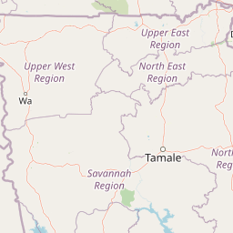
Map view of Gbele Resource Centre

Use this park location map to pinpoint Gbele Resource Centre in Ghana, understand its exact geographic position, and read its mapped placement within the surrounding landscape more clearly.

Pigeon | © OpenStreetMap contributors

Location context for Gbele Resource Centre

Upper West Region
Park atlas

Compare surrounding regional savanna landscapes and wildlife habitats

Explore Protected Areas and Other Parks Near Gbele Resource Centre

Browse other protected areas and national parks located near Gbele Resource Centre in the northwestern Ghanaian savanna zone. Comparing these adjacent conservation landscapes provides deeper insight into regional biodiversity distribution and habitat connectivity across the region.
National parkSavannah Region
About 80 km away#1 closest

Southeast

Mole National Park: A Premier Protected Landscape in Ghana's Savannah Region

Explore mapped boundaries and Guinea savannah ecosystems.

Mole National Park represents a significant protected landscape within Ghana's Savannah Region, serving as the country's largest national park and a crucial conservation area for West African wildlife. The park's geography is defined by extensive Guinea savannah, characterized by grasslands with scattered woodlands and a prominent escarpment along its southern edge. Its vast expanse offers a unique opportunity to study mapped park boundaries and understand the ecosystem's role in regional conservation efforts. Discover the unique landscape context and protected area identity of this major West African wildlife refuge.

Area
4,840 km²
Established
1958
IUCN
II
Visitors
17.8K annual
Wildlife reserveUpper West Region
About 107 km away#2 closest

Southwest

Wechiau Community Hippo Sanctuary: Protected River Landscapes and Savanna Wildlife Reserve

Upper West Region, Ghana: Riverine ecology and community-managed boundaries

Wechiau Community Hippo Sanctuary encompasses a protected stretch of the Black Volta, providing essential habitat for hippopotamuses in northwestern Ghana. This wildlife reserve features a diverse landscape of riverine forests, sandbanks, and savanna trails. The sanctuary demonstrates how local traditional governance maintains critical natural terrain while fostering an integrated cultural and ecological landscape.

Established
1999
Relief
Lowland
Scope
Terrestrial
Water
Major water bodies
Watercolor depiction of a river flowing through a landscape with green trees and distant mountains under a light sky
National parkBurkina Faso
About 135 km away#3 closest

Northeast

Kaboré Tambi National Park: Burkina Faso's Largest National Park and Protected Landscape

Explore the mapped savanna and birdwatching geography of this vital West African area.

Kaboré Tambi National Park represents a critical protected area in Burkina Faso, spanning a considerable expanse of Sudan-Guinea savanna. The park's geography is defined by the Nazinon River and a mosaic of woodland and grassland ecosystems, making it a significant site for understanding regional protected lands and landscape ecology. It offers a valuable point of reference for atlas-based exploration of West African natural areas.

Area
1,555 km²
Established
1976
IUCN
II
Relief
Lowland
National parkBurkina Faso
About 151 km away#4 closest

Northwest

Deux Balés National Park: Burkina Faso's Elephant Sanctuary and Savanna Protected Landscape

Explore mapped terrain and key geographic features of this protected area.

Deux Balés National Park serves as a vital protected area within Burkina Faso, acclaimed for harboring the largest elephant population in West Africa. This national park's protected landscape is defined by undulating granitic plains, lateritic plateaux, and distinct gallery forests lining the Black Volta River. The presence of ancient African baobab trees adds a unique visual character to the savanna ecosystem. Investigating this park reveals its significance for regional conservation, its mapped geographic boundaries, and its role within the broader context of protected lands in West Africa.

Area
810 km²
Established
1937
IUCN
II
Relief
Lowland
Watercolor illustration of a landscape with green fields, trees, and a body of water
National parkIvory Coast
About 171 km away#5 closest

Southwest

Comoé National Park: Geographic and Environmental Overview of the Ivory Coast Reserve

Mapping the transitions of West Africa's largest protected savanna ecosystem.

Comoé National Park serves as an ecological crossroads in north-eastern Ivory Coast, protecting 11,500 square kilometers of diverse terrain. The park hosts an extraordinary gradient of habitats, from dense gallery forests hugging the 230 kilometer stretch of the Comoé River to open, dry Sudanian savannas. Its geological foundation, featuring dramatic granite inselbergs and wide plains, supports a highly complex network of life, making it a cornerstone for understanding West African regional conservation and landscape ecology.

Area
11,500 km²
Established
1983
IUCN
II
Relief
Lowland
A soft watercolor illustration showing a calm pond in the foreground, with gentle grassy hills and sparse trees in the background.
National parkIvory Coast
About 171 km away#6 closest

Southwest

Comoé National Park: Geographic Overview and Protected Landscape Analysis

Mapping the savanna and river corridors of Ivory Coast

Comoé National Park spans the northeastern reaches of Ivory Coast, providing a crucial protected space for West Sudanian savanna and gallery forests. This large-scale reserve is characterized by the hydrological influence of the Comoé River, which carves through the undulating plains to create seasonal floodplains and dense riverine corridors that serve as essential habitat for regional wildlife populations.

Area
11,491.5 km²
Established
1968
IUCN
II
Relief
Upland
Watercolor illustration showing a calm river flowing through a soft landscape with distant rolling hills and light vegetation.
Wildlife reserveBurkina Faso
About 201 km away#7 closest

Northeast

Lac de Bagré Wildlife Reserve: Mapping the Inland Reservoir of Central Burkina Faso

A critical wetland site within the Nakambé River valley.

Lac de Bagré acts as a major freshwater reservoir, stretching through the Boulgou and Zoundwéogo provinces of Burkina Faso. This artificial lake, created by the Bagré Dam, supports a unique ecological profile as a Ramsar-recognized wetland, offering a deep look into the intersection of hydrological infrastructure and protected Sahelian landscapes.

Area
367.93 km²
Established
1992
Water
Water-dominated
A soft, light-toned watercolor painting of a river flowing through a park or nature reserve with gentle hills and scattered trees in the background.
Nature reserveOubritenga
About 231 km away#8 closest

Northeast

Forêt classée de Gonsé Nature Reserve: Protected Landscape and Geographic Atlas Record

Sudano-Sahelian woodland and Massili River floodplain context

Examine the protected landscape of Forêt classée de Gonsé, a nature reserve in the Oubritenga region of Burkina Faso. This record details the park's savanna recovery, riverine habitats, and the legacy of its reforestation history as part of the West African Sudano-Sahelian interface.

Relief
Lowland
Climate
Subtropical
Access
Easy access
Scope
Terrestrial

Common questions about visiting, size, designation, and location context for Gbele Resource Centre

Gbele Resource Centre FAQs for park facts, access, geography, and protected area context

Find quick answers about Gbele Resource Centre, including protected-area facts, park geography, trail and visitor context, and how the park fits into its surrounding country and regional landscape.
MoriAtlas Explorer

Continue Your Protected Areas Search Across the Global Atlas

Deepen your exploration by continuing the structured search for national parks and protected areas worldwide. Utilize the comprehensive filtering capabilities to compare different conservation landscapes and refine your understanding of global park geography. Discover more about the distribution and characteristics of protected natural areas.

Global natural geography