

Mori Atlas logo
National parkGoldfields Woodlands National Park

Discover the geographic boundaries and landscape context of this national park.

Goldfields Woodlands National Park: A Mapped Protected Area in Goldfields-Esperance, Australia

Goldfields Woodlands National Park represents a significant protected area within Australia's Goldfields-Esperance region. This page offers an atlas-focused exploration of the park's mapped boundaries and its distinct geographic setting. Users can engage with its regional context, understanding its place within the broader landscape and the unique protected-area identity it holds.

Western AustraliaMallee WoodlandsSemi-DesertGreat Western WoodlandsProtected AreaNational Park

Goldfields Woodlands National Park

National park

Park overview

Structured park overview, official facts, and landscape profile for Goldfields Woodlands National Park

Goldfields Woodlands National Park park facts, protected area profile, and essential visitor context
Review the core facts for Goldfields Woodlands National Park, including designation, size, terrain, visitor scale, habitats, and operating context in one park-focused overview.

About Goldfields Woodlands National Park

Goldfields Woodlands National Park occupies a dramatic stretch of Western Australia's inland landscape, where vast woodlands of malle trees and diverse shrublands create a distinctive semi-desert environment. The park sits within the Coolgardie bioregion, an area characterised by low rainfall, ancient soils, and vegetation adapted to harsh seasonal conditions. What makes this park particularly significant is its role as a core protected area within the Great Western Woodlands, a sprawling network of intact mallee woodlands and shrublands that represents one of the world's largest remaining examples of this ecosystem type. The landscape features gently undulating terrain with granite outcrops, sandplains, and多层 of vegetation that changes with the seasons. The park is bisected by the Great Eastern Highway, making it accessible while maintaining its wild character. Beyond its ecological importance, the park serves as a repository for human history, preserving traces of both the Kalaamaya people's long connection to this country and the more recent story of gold rush settlement, water infrastructure, and the development of the goldfields region.

Quick facts and research context for Goldfields Woodlands National Park

Goldfields Woodlands National Park covers 64,628 hectares in the Goldfields-Esperance region of Western Australia, located along the Great Eastern Highway between Perth and Kalgoorlie. The park was established in 2000 and is administered by the Department of Biodiversity, Conservation and Attractions. It borders Boorabbin National Park to the west and the Goldfields Woodlands Conservation Park to the east. The traditional owners of the land are the Kalaamaya people, and the park forms part of the globally significant Great Western Woodlands area.

Park context

Deeper park guide and search-rich context for Goldfields Woodlands National Park

Goldfields Woodlands National Park history, landscape, wildlife, and travel context
Explore Goldfields Woodlands National Park through its history, landscape character, ecosystems, wildlife, conservation priorities, cultural context, and seasonal travel timing in a structured park guide built for atlas discovery and search intent.

Why Goldfields Woodlands National Park stands out

Goldfields Woodlands National Park is best known for its extensive semi-desert mallee woodlands and the dramatic contrast between ancient landscape and gold rush heritage. The park preserves one of the world's largest remaining intact mallee woodland ecosystems within the Great Western Woodlands, a landscape of national and international conservation significance. It also encompasses the historic Holland Track, a pioneering route through the goldfields, and elements of the Goldfields Water Supply Scheme, providing a rare combination of biodiversity protection and cultural heritage preservation in a region defined by its mining history.

Goldfields Woodlands National Park history and protected-area timeline

Goldfields Woodlands National Park was formally established on 14 April 2000, creating protected status for a significant portion of the remaining semi-desert woodlands in Western Australia's goldfields region. The establishment of the park came as recognition of the ecological significance of the Great Western Woodlands and the need to preserve both biodiversity and cultural heritage in this part of the state. The land has a much longer human story, with the traditional owners being the Kalaamaya people whose connection to country spans thousands of years. The colonial period saw this region transformed by the gold rush of the 1890s, with the Holland Track providing a vital route through the terrain and the Goldfields Water Supply Scheme bringing essential water to the mining settlements. These human history elements pass through the park today, linking the natural landscape to the story of settlement and development that defines the Goldfields region.

Goldfields Woodlands National Park landscape and geographic character

The landscape of Goldfields Woodlands National Park exemplifies the semi-desert woodland character of the Coolgardie bioregion. The terrain consists of gently undulating sandplains and ridges, interspersed with granite outcrops and occasional breakaways. The vegetation is dominated by mallee eucalypts, which form the characteristic multi-stemmed growth pattern adapted to the region's low rainfall and periodic fire. Between the woodland bands, diverse shrublands of wattles, saltbush, and other drought-adapted species create a complex vegetation mosaic. The soils are typically deep sands and laterites, reflecting the ancient weathering of the landscape. Despite the seemingly harsh environment, the park supports remarkable biodiversity, with different vegetation communities providing habitat for numerous species. The overall impression is one of vast openness, where the sky dominates and the woodlands extend to the horizon, interrupted only by the occasional granite dome or the linear corridor of the highway.

Goldfields Woodlands National Park ecosystems, habitats, and plant life

The nature of Goldfields Woodlands National Park is defined by its position within the Great Western Woodlands, a globally significant ecosystem. The mallee woodlands of the park represent one of the largest remaining intact areas of this typically fire-prone, semi-arid forest type. These woodlands support a remarkable diversity of plant species, with numerous endemic plants adapted to the specific conditions of the goldfields. The park's position in the Coolgardie bioregion places it at the intersection of several biogeographic influences, resulting in a mix of species from different regional centres. The shrubland understories are particularly diverse, with many species flowering in response to seasonal rains. The park's conservation value is enhanced by its connection to adjacent protected areas, forming a larger network of preserved habitat within this largely cleared agricultural and mining region.

Goldfields Woodlands National Park wildlife and species highlights

The wildlife of Goldfields Woodlands National Park reflects the semi-desert woodland environment of the goldfields region. Birds are particularly diverse, with numerous honeyeaters, parrots, and cockatoos exploiting the nectar and seed resources of the mallee woodlands. Reptiles are well-represented, with various skinks, dragons, and snakes adapted to the variable climate. Mammals include a range of marsupials, though many species have declined due to changed fire regimes and the introduction of feral animals. The park's intact vegetation and connection to other protected areas provide important habitat for species that require large territories or connectivity between habitats. The seasonal nature of the environment, with wet winters and dry summers, creates varying wildlife activity patterns throughout the year.

Goldfields Woodlands National Park conservation status and protection priorities

Goldfields Woodlands National Park plays a crucial role in conserving one of the world's largest remaining intact mallee woodland ecosystems. The Great Western Woodlands, of which this park is a core component, represents an internationally significant area of biodiversity that remains largely unmodified compared to similar ecosystems elsewhere in Australia. The park protects representative samples of the Coolgardie bioregion's vegetation communities, including mallee woodlands, shrublands, and granite outcrop associations. Its establishment in 2000 acknowledged the need to preserve both the natural values of the region and its cultural heritage, including the route of the historic Holland Track and infrastructure associated with the Goldfields Water Supply Scheme. The park forms part of a network of protected areas that help maintain ecological connectivity across this semi-arid landscape.

Goldfields Woodlands National Park cultural meaning and human context

Goldfields Woodlands National Park encompasses the traditional Country of the Kalaamaya people, whose connection to this land extends back thousands of years. The park also preserves the more recent history of the gold rush era, with the Holland Track, a pioneering route established during the 1890s gold rush, passing through the park. This track connected the settled agricultural areas with the goldfields and represents an important piece of colonial history. Additionally, elements of the Goldfields Water Supply Scheme, the remarkable engineering achievement that brought water to the goldfields from the Perth region, pass through the park. This combination of indigenous heritage and colonial development makes the park a place where natural and cultural values intersect, telling the story of human adaptation to and interaction with this challenging landscape.

Top sights and standout views in Goldfields Woodlands National Park

The defining highlight of Goldfields Woodlands National Park is its position within the Great Western Woodlands, one of the world's largest remaining intact mallee woodland landscapes. Visitors experience vast semi-desert woodlands stretching to the horizon, with the distinctive multi-stemmed mallee trees creating a park-like landscape. The historic Holland Track provides a tangible connection to the gold rush era, while the presence of the Goldfields Water Supply Scheme demonstrates human ingenuity in overcoming the challenges of this arid environment. The park offers a different kind of Australian wilderness experience, one defined by open skies, ancient soils, and resilient ecosystems adapted to low rainfall and seasonal variation.

Best time to visit Goldfields Woodlands National Park

The best time to visit Goldfields Woodlands National Park is during the cooler months from April to October, when temperatures are more comfortable for outdoor exploration. Winter and spring typically bring the most atmospheric conditions, with occasional rain triggering flowering in the shrublands and adding freshness to the landscape. Summer months can be extremely hot, limiting户外 activities and increasing fire risk. The park is accessible year-round via the Great Eastern Highway, though visitors should be aware of the remote nature of the area and prepare accordingly, carrying adequate supplies and fuel.
Park location guide

Geography guide, regional context, and park location map for Goldfields Woodlands National Park

Goldfields Woodlands National Park park geography, regions, and map view in Australia
Understand where Goldfields Woodlands National Park sits in Australia through a broader geographic reading of the surrounding landscape, nearby location context, and its mapped position within the national park landscape.

How Goldfields Woodlands National Park fits into Australia

Australia is a constitutional monarchy and federal parliamentary democracy comprising six states and ten territories. With a population of nearly 28 million, it is one of the world's most urbanised countries, with most people concentrated on the eastern seaboard. The country has a high Human Development Index and is known for its cultural diversity, ancient Aboriginal heritage, and unique wildlife.

Wider geography shaping Goldfields Woodlands National Park in Australia

Australia occupies the entire Australian continent, the island of Tasmania, and numerous smaller islands. It is the world's flattest and driest inhabited continent, featuring vast deserts in the interior (the Outback), tropical rainforests along the eastern coast, and a coastline bordering the Indian and Pacific Oceans.

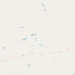
Map view of Goldfields Woodlands National Park

Use this park location map to pinpoint Goldfields Woodlands National Park in Australia, understand its exact geographic position, and read its mapped placement within the surrounding landscape more clearly.

Pigeon | © OpenStreetMap contributors

Location context for Goldfields Woodlands National Park

Goldfields-EsperanceWestern Australia
Park atlas

Explore the Surrounding Coolgardie Bioregion Landscapes and Compare Other Protected Mallee Woodlands in Western Australia

Discover More National Parks and Protected Areas Near Goldfields Woodlands National Park
Continue your park exploration from Goldfields Woodlands National Park by browsing additional protected areas and national parks across the Goldfields-Esperance region of Western Australia. Compare mapped park geography, observe varied semi-desert woodland ecosystems, and trace the spread of the Great Western Woodlands within its regional context.
National parkWestern Australia

Boorabbin National Park: Exploring Western Australia's National Park Landscape and Boundaries

Mapped protected area context within Western Australia's geography.

Boorabbin National Park represents a distinct protected landscape within the expansive geography of Western Australia. This entry provides focused insight into the park's identity as a national park, highlighting its specific mapped boundaries and its contribution to the regional atlas of protected areas. Understanding Boorabbin National Park's geographic setting allows for a deeper appreciation of Western Australia's natural terrain and conservation efforts.

Area
281.53 km²
Established
1977
IUCN
II
Relief
Upland
National parkWestern Australia

Goongarrie National Park: A Mapped Protected Landscape in Western Australia

Explore regional geography and park boundaries.

Goongarrie National Park represents a distinct protected landscape within the extensive geography of Western Australia. This page offers detailed atlas-style information, focusing on its mapped boundaries and its place as a national park within the region's conservation network. Understand the geographic context of Goongarrie National Park and its contribution to the mapped protected areas of Australia.

Area
603.97 km²
Established
1978
IUCN
II
Climate
Arid
National parkWestern Australia

Frank Hann National Park: Explore Its Protected Area Geography and Mapped Boundaries

Western Australia's protected national park landscape.

Frank Hann National Park is a designated national park providing crucial insight into Western Australia's protected natural landscapes. This entry focuses on its precise geographic scope and mapped boundaries, allowing for detailed atlas-based exploration. Understand the park's identity as a protected area and its position within the broader regional geography of this large Australian state, ideal for focused landscape discovery.

Area
675.5 km²
Established
1970
IUCN
II
Relief
Lowland
National parkWestern Australia

Peak Charles National Park: A National Park in Western Australia's Mapped Landscape

Discover its protected area status and geographic setting.

Peak Charles National Park is a vital component of Western Australia's protected natural areas. This dedicated page provides an atlas-centric view, focusing on the park's geographic scope, its mapped boundaries, and the surrounding regional landscape context. It serves as an essential resource for understanding the park's protected land identity and its contribution to the broader geography of Western Australia.

Area
399.59 km²
Established
1979
IUCN
II
Relief
Mountain
National parkWestern Australia

Stokes National Park National Park: Mapped Boundaries and Regional Geography

Western Australia's protected landscape identity.

Stokes National Park represents a significant protected entity within the expansive geography of Western Australia. This detailed page provides users with essential mapping information, focusing on the park's designated boundaries and its role within the broader atlas of Australian conservation landscapes. Explore the specific geographic context that defines this national park and understand its natural landscape features.

Area
97.26 km²
Established
1976
IUCN
II
Relief
Lowland
Watercolor illustration showing mountains in the background, green vegetation, and pink meadows
National parkWestern Australia

Fitzgerald River National Park: A Western Australian Protected Landscape of Global Botanical Importance

Discover its mapped terrain, endemic flora, and UNESCO Biosphere Reserve status.

Fitzgerald River National Park stands as a protected landscape of immense ecological value in Western Australia. This national park is celebrated for its extraordinary botanical diversity, featuring more endemic plant species than any other conservation reserve in Australia. Its varied terrain, from rugged mountain ranges to coastal cliffs, provides a rich tapestry of natural habitats. As a designated UNESCO Biosphere Reserve, it offers a unique opportunity to explore mapped geographic features and understand the critical role of protected areas in conserving rare flora and distinct Mediterranean ecosystems.

Area
2,972.11 km²
Established
1973
IUCN
II
Visitors
40K annual
National parkWestern Australia

Cape Le Grand National Park: Western Australia National Park Geographic Context and Landscape Exploration

Mapped protected area boundaries and regional natural terrain discovery.

Cape Le Grand National Park is an important national park in Western Australia, providing a distinct focus for geographic and atlas-based discovery. Understanding its protected landscape identity and its placement within the state's natural geography offers valuable insight into regional conservation areas. This page serves as a canonical entry point for exploring the mapped features and the broader geographic significance of Cape Le Grand National Park, detailed for structured atlas exploration.

Area
318.01 km²
Established
1966
IUCN
II
Relief
Mixed relief
National parkAustralia

Dryandra Woodland National Park: Australia National Park Atlas and Protected Landscape

Explore its mapped boundaries and natural terrain.

Dryandra Woodland National Park stands as a protected area within Australia, designated as a national park. This page provides a detailed look at its geographic setting, mapped landscape features, and its role in the country's protected lands. Understand the protected boundaries and natural terrain that characterize this important conservation site, contributing to a comprehensive view of Australia's natural atlas.

Area
280.66 km²
Established
2022
Visitors
30K annual
Relief
Upland

Common questions about visiting, size, designation, and location context for Goldfields Woodlands National Park

Goldfields Woodlands National Park FAQs for park facts, access, geography, and protected area context
Find quick answers about Goldfields Woodlands National Park, including protected-area facts, park geography, trail and visitor context, and how the park fits into its surrounding country and regional landscape.
MoriAtlas Explorer

Continue Your Protected Areas Search Across the Global Atlas

Deepen your exploration by continuing the structured search for national parks and protected areas worldwide. Utilize the comprehensive filtering capabilities to compare different conservation landscapes and refine your understanding of global park geography. Discover more about the distribution and characteristics of protected natural areas.

Global natural geography