Mori Atlas logo
National parkGull Rock National Park

Trace the mapped boundaries and natural terrain of this Western Australia national park.

Gull Rock National Park: Protected Landscape and Geographic Atlas Exploration in Western Australia

Gull Rock National Park represents a distinct protected landscape within the vast geography of Western Australia. This national park offers a focused point for understanding regional natural terrain and the precise mapped boundaries of protected conservation areas. Explore its unique geographic identity as part of a larger atlas of Australia's diverse landscapes, providing valuable context for the distribution of national parks.

coastal national parkWestern Australiaheathland ecosystemgranite headlandsbanksia woodlandsouthwest Australian flora

Gull Rock National Park

National park

Park overview

Structured park overview, official facts, and landscape profile for Gull Rock National Park

Gull Rock National Park park facts, protected area profile, and essential visitor context
Review the core facts for Gull Rock National Park, including designation, size, terrain, visitor scale, habitats, and operating context in one park-focused overview.

About Gull Rock National Park

Gull Rock National Park represents one of the relatively intact coastal reserves in the Great Southern region of Western Australia, protecting a landscape that has largely retained its natural character despite surrounding agricultural development. The park's setting along the southern coast places it within a biogeographically significant zone where the temperate forests and heathlands of southwest Australia meet the Southern Ocean. The reserve encompasses a variety of landforms, with granite domes and rocky headlands providing visual anchors and supporting distinct plant communities adapted to exposed conditions. Between the headlands, sandy beaches create recreational access points while also buffering interdunal wetland systems that provide habitat diversity. The park takes its name from a small island offshore at Ledge Beach, though this feature lies outside the park's boundaries. Adjacent conservation areas including the Mount Martin Botanical Reserve to the west and Two Peoples Bay Nature Reserve approximately 10 kilometers to the east create a corridor of protected land that supports broader landscape connectivity.

Quick facts and research context for Gull Rock National Park

Gull Rock National Park occupies a coastal position in the Great Southern region of Western Australia, approximately 25 kilometers east of Albany. The reserve was established in 2006 and covers 21.04 square kilometers. The landscape is defined by granite headlands including Mount Taylor and Mount Martin, sandy beaches, and interdunal wetland systems. The park protects an almost unspoilt example of the coastal east Kalgan vegetation system, featuring a patchwork of banksia woodland, sheoak forest, open heath, and sedgeland habitats. The area supports endangered bird species including the noisy scrub-bird, western bristlebird, and western whipbird, as well as the western ringtail possum.

Park context

Deeper park guide and search-rich context for Gull Rock National Park

Gull Rock National Park history, landscape, wildlife, and travel context
Explore Gull Rock National Park through its history, landscape character, ecosystems, wildlife, conservation priorities, cultural context, and seasonal travel timing in a structured park guide built for atlas discovery and search intent.

Why Gull Rock National Park stands out

Gull Rock National Park is best known for protecting the most significant remaining stands of scarlet banksia (Banksia coccinea) in the region, a striking endemic species that forms dense displays across the heathland areas. The park also preserves critical habitat for several endangered vertebrate species, most notably the noisy scrub-bird, western bristlebird, and western whipbird, which are restricted to the dense heath and understory vegetation of the southwest Australian floristic region. The coastal heath communities, growing in a challenging environment where salt-laden air stunts growth, represent a resilient and ecologically significant plant assemblage.

Gull Rock National Park history and protected-area timeline

Gull Rock National Park was established in 2006, becoming Western Australia's 97th national park. The designation represented recognition of the area's ecological significance and the need for formal protection of its coastal ecosystems and threatened species habitat. Prior to national park status, the area had been managed under various conservation designations, with the Mount Martin Botanical Reserve providing longer-term protection for portions of the western boundary. The establishment of the park reflected growing understanding of the importance of coastal heathland conservation in the southwest Australian floristic region, one of the world's biodiversity hotspots. The Department of Environment and Conservation (now the Department of Biodiversity, Conservation and Attractions) assumed management responsibility for the reserve.

Gull Rock National Park landscape and geographic character

The physical landscape of Gull Rock National Park is defined by a series of granite headlands and rocky ridges that project into King George Sound, creating a crenulated coastline of alternating promontories and sheltered beaches. Mount Taylor and Mount Martin form the prominent elevated features within the park, part of the Gardner Landform unit, with exposed granite surfaces supporting distinctive drought-tolerant plant communities. The beaches between the headlands are backed by foredune systems and interdunal wetlands that contain permanent and seasonal water bodies, adding hydrological complexity to the coastal zone. The northern portions of the park transition from the coastal fringe into farmland, though the reserve itself maintains natural vegetation cover. The overall terrain is relatively subdued in elevation change but visually dramatic where granite outcrops break through the heath and woodland canopy.

Gull Rock National Park ecosystems, habitats, and plant life

The ecological character of Gull Rock National Park is defined by the coastal east Kalgan vegetation system, a complex mosaic of habitats that reflects the interplay of soil types, exposure, moisture availability, and fire history. The park contains banksia woodland dominated by Banksia attenuata on deeper soils, sheoak forest in more sheltered positions, and extensive open heath across the majority of the reserve. The heath communities are particularly significant, supporting the most significant remaining stands of scarlet banksia (Banksia coccinea) in the region. This striking species forms dense, orange-red flower displays that are a defining visual element of the park's vegetation. The lower elevations of Mount Taylor support Melaleuca striata coastal heath, where plant growth is visibly stunted by proximity to the ocean and salt-laden winds. Sedge-dominated wetlands contain Anarthria scabra as the dominant species alongside various other hydrophilic plants. The plant diversity is notable, with numerous rare and restricted species occurring within the park's boundaries.

Gull Rock National Park wildlife and species highlights

Gull Rock National Park supports several endangered bird species that depend on the dense heathland and understory vegetation for survival. The noisy scrub-bird, western bristlebird, and western whipbird are all known to inhabit the area, representing species with highly restricted distributions in the southwest Australian floristic region. The western ringtail possum, a marsupial listed as endangered, is frequently sighted within the park, utilizing the dense vegetation for shelter and foraging. Beyond these flagship threatened species, the diverse habitats support a range of other fauna including reptiles, invertebrates, and smaller mammals. A particularly notable discovery was the finding of the rare and ancient Main's assassin spider within the park during a 2008 survey, confirming the presence of this threatened arthropod species.

Gull Rock National Park conservation status and protection priorities

The conservation significance of Gull Rock National Park stems from its role in protecting representative examples of the southwest Australian floristic region's coastal ecosystems while providing critical habitat for threatened species. The park preserves one of the most significant remaining occurrences of scarlet banksia, a species whose populations have declined across its range. However, this and other plant communities face ongoing threats from Phytophthora dieback, a soil-borne pathogen that causes root rot and has devastated susceptible species across many southwest Australian protected areas. The presence of multiple endangered vertebrate species underscores the importance of the reserve as a conservation stronghold. Management focuses on maintaining ecosystem integrity, managing visitor impacts, and implementing measures to mitigate the spread of dieback disease.

Gull Rock National Park cultural meaning and human context

Gull Rock National Park lies within the traditional Country of the Minang and other Aboriginal peoples of the Great Southern region. The coastal areas and surrounding landscapes have been part of Indigenous cultural landscapes for thousands of years, though detailed cultural history specific to the park area is not extensively documented in the available source material. The park's establishment in 2006 represents relatively recent formal recognition of the area's natural values within the broader conservation framework of Western Australia.

Top sights and standout views in Gull Rock National Park

The most outstanding feature of Gull Rock National Park is its exceptional scarlet banksia heathlands, which represent the most significant remaining stands of this striking species in the region. The coastal granite headlands, particularly Mount Taylor and Mount Martin, provide panoramic views over King George Sound and the Southern Ocean while supporting unique plant communities adapted to extreme exposure. The park's role as habitat for endangered species including the noisy scrub-bird, western bristlebird, western whipbird, and western ringtail possum elevates its conservation importance. The interdunal wetlands add ecological diversity and support birdlife, while the relatively intact nature of the coastal vegetation system makes this a valuable reference site for understanding southwest Australian coastal ecosystems.

Best time to visit Gull Rock National Park

The optimal time to visit Gull Rock National Park is during the austral spring and early summer months, from September through December, when the heathland vegetation is at its most vibrant and many plant species are in flower. The scarlet banksia typically flowers during this period, creating striking displays of orange-red across the heath. Autumn and winter bring milder temperatures and potentially more overcast conditions but still allow for enjoyable exploration of the coastal trails. Summer months can be warm and may experience higher visitor numbers, though the coastal breezes provide some moderation. The park can be visited year-round, though winter rainfall may affect some trail conditions.
Park location guide

Geography guide, regional context, and park location map for Gull Rock National Park

Gull Rock National Park park geography, regions, and map view in Australia
Understand where Gull Rock National Park sits in Australia through a broader geographic reading of the surrounding landscape, nearby location context, and its mapped position within the national park landscape.

How Gull Rock National Park fits into Australia

Australia is a constitutional monarchy and federal parliamentary democracy comprising six states and ten territories. With a population of nearly 28 million, it is one of the world's most urbanised countries, with most people concentrated on the eastern seaboard. The country has a high Human Development Index and is known for its cultural diversity, ancient Aboriginal heritage, and unique wildlife.

Wider geography shaping Gull Rock National Park in Australia

Australia occupies the entire Australian continent, the island of Tasmania, and numerous smaller islands. It is the world's flattest and driest inhabited continent, featuring vast deserts in the interior (the Outback), tropical rainforests along the eastern coast, and a coastline bordering the Indian and Pacific Oceans.

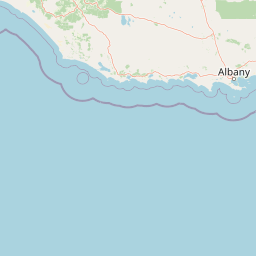
Map view of Gull Rock National Park

Use this park location map to pinpoint Gull Rock National Park in Australia, understand its exact geographic position, and read its mapped placement within the surrounding landscape more clearly.

Pigeon | © OpenStreetMap contributors

Location context for Gull Rock National Park

Western Australia
Park atlas

Compare protected coastal landscapes and regional park geography within Australia's Great Southern region.

Explore Other National Parks and Protected Areas Near Gull Rock National Park, Western Australia
Discover additional national parks and protected areas situated around Gull Rock National Park, tracing Western Australia's unique coastal ecosystems and regional conservation efforts. Explore these neighboring reserves to understand the broader spread of protected landscapes, comparing diverse granite headlands, banksia heathlands, and wetland habitats across the Great Southern region.
National parkWestern Australia

Torndirrup National Park National Park: Mapped Boundaries and Regional Landscape Context

Explore protected lands within Western Australia's geography.

Torndirrup National Park serves as a significant protected natural area, offering valuable insights into the geographic character of Western Australia. This detailed entry focuses on its mapped boundaries and its role as a protected landscape, providing essential context for atlas-based exploration of Australia's diverse regions and natural terrains.

Area
39.36 km²
Established
1918
IUCN
II
Visitors
250K annual
National parkWestern Australia

Waychinicup National Park: National Park Protected Landscape Atlas Entry

Explore Western Australia's mapped natural landscapes and park geography.

Gain a structured understanding of Waychinicup National Park as a key protected landscape within Western Australia. This detailed atlas entry focuses on its geographic distribution and mapped boundaries, providing essential context for regional park and natural landscape exploration. Discover the unique characteristics of this national park's setting and its place within the broader mapped terrain.

Area
39.82 km²
Established
1990
IUCN
II
Relief
Mixed relief
National parkWestern Australia

Porongurup National Park: Ancient Granite Peaks and Karri Forest Protected Landscape

Mapped terrain and geologic history in Western Australia.

Delve into Porongurup National Park, a protected landscape in Western Australia characterized by its ancient, billion-year-old granite peaks and a rare outlier of towering karri forest. This national park offers a unique geographic perspective, showcasing dramatic mountain terrain that has stood for eons. Explore the mapped boundaries and the distinct ecosystems that thrive within this ancient mountain system, providing rich context for regional atlas discovery and understanding the park's geological significance.

Area
26.21 km²
Established
1971
IUCN
II
Relief
Mountain
Watercolor illustration of rolling hills, mountains, and a coastal body of water
National parkWestern Australia

West Cape Howe National Park: Western Australia's Southernmost Coastal Protected Landscape

Explore dramatic sea cliffs, ancient karri forests, and Torbay Head.

West Cape Howe National Park offers a distinct protected landscape experience in Western Australia, highlighted by its position at mainland Australia's southernmost point, Torbay Head. This park showcases a rugged 23-kilometer stretch of the Southern Ocean coastline, featuring towering sea cliffs that descend to pristine beaches and rocky shores. Inland, visitors find ancient karri forests and diverse vegetation types, contributing to a rich mosaic of protected habitats. Its geographic significance and unique coastal terrain make it a key destination for understanding regional protected area geography.

Area
36.05 km²
Established
1985
IUCN
II
Relief
Lowland
National parkWestern Australia

Hassell National Park National Park: Mapped Protected Landscape in Western Australia

Explore the geographic identity and park boundaries of Hassell National Park.

Hassell National Park offers a focused view of protected natural landscapes within Western Australia. This atlas entry details the park's specific geographic scope and its designation as a national park, providing essential context for understanding its mapped features and regional landscape. Explore how Hassell National Park contributes to the protected area geography of the state.

Area
12.65 km²
Established
1971
IUCN
II
Scope
Mixed
National parkGreat Southern

Mount Lindesay National Park: Australian National Park Protected Landscape Details

Explore mapped boundaries and regional geographic context in Great Southern.

Gain a structured understanding of Mount Lindesay National Park, a designated national park in Australia's Great Southern region. This detail view focuses on its protected landscape identity, mapped geographic features, and its place within the nation's network of conservation areas. Discover the specific terrain and regional atlas context that makes this park a distinct element of Australia's natural geography.

Area
395.73 km²
Established
2004
IUCN
II
Relief
Mountain
Watercolor illustration of a coastal landscape with green vegetation, pink rock formations, and a calm body of water
National parkWestern Australia

William Bay National Park: Mapped Protected Area in Western Australia's Geography

Explore its national park boundaries and regional landscape context.

Delve into the protected landscape of William Bay National Park, a designated national park situated within the diverse geography of Western Australia. This resource provides critical information on its mapped boundaries and its role as a protected natural area. Understand the park's specific geographic setting and its contribution to the regional atlas of conservation landscapes, essential for detailed park and landscape discovery.

Area
17.34 km²
Established
1971
IUCN
II
Visitors
238K annual
National parkGreat Southern

Mount Roe National Park: Detailed Protected Landscape and Geographic Exploration

Mapped boundaries and natural terrain of this national park.

Mount Roe National Park offers a distinct protected landscape for atlas exploration, situated within the geographic scope of the Great Southern region. This detail page provides a structured view of the park's mapped boundaries and its natural terrain. Understand how Mount Roe National Park contributes to the regional geography and the overall map of protected areas in Australia.

Area
1,278 km²
Established
2004
IUCN
II
Scope
Terrestrial

Common questions about visiting, size, designation, and location context for Gull Rock National Park

Gull Rock National Park FAQs for park facts, access, geography, and protected area context
Find quick answers about Gull Rock National Park, including protected-area facts, park geography, trail and visitor context, and how the park fits into its surrounding country and regional landscape.
MoriAtlas Explorer

Continue Your Protected Areas Search Across the Global Atlas

Deepen your exploration by continuing the structured search for national parks and protected areas worldwide. Utilize the comprehensive filtering capabilities to compare different conservation landscapes and refine your understanding of global park geography. Discover more about the distribution and characteristics of protected natural areas.

Global natural geography