
Mori Atlas logo
National parkHakkari Cilo-Sat Mountains National Park

Discover mapped protected boundaries within the spectacular alpine terrain of Hakkari Province.

Hakkari Cilo-Sat Mountains National Park: Turkey's Premier High-Altitude Glacial Landscape

(Hakkâri Cilo ve Sat Dağları Milli Parkı)

MoriAtlas presents Hakkari Cilo-Sat Mountains National Park, a recently established national park in Turkey's southeastern Anatolian region. This protected landscape centers on the dramatic Cilo and Sat mountain ranges, characterized by deep glacial valleys, active glaciers, alpine meadows, and Turkey's second-highest peak, Uludoruk. Our platform offers detailed geographic context and mapped boundaries, allowing for a structured exploration of this significant mountain ecosystem and its unique regional landscape.

Mountain parksGlacial landscapesAlpine environmentsEndemic speciesHigh altitudeEastern Turkey
Stylized illustration of snow-capped mountains, winding river, and pine trees

Hakkari Cilo-Sat Mountains National Park

National park

Park overview

Structured park overview, official facts, and landscape profile for Hakkari Cilo-Sat Mountains National Park

Hakkari Cilo-Sat Mountains National Park park facts, protected area profile, and essential visitor context

Review the core facts for Hakkari Cilo-Sat Mountains National Park, including designation, size, terrain, visitor scale, habitats, and operating context in one park-focused overview.

About Hakkari Cilo-Sat Mountains National Park

Hakkari Cilo-Sat Mountains National Park protects one of Turkey's most impressive and ecologically significant mountain landscapes in the remote southeastern corner of the country. The protected area was established in September 2020 as the 45th Turkish national park, reflecting the country's growing emphasis on conserving its high-altitude biodiversity and geological heritage. The park encompasses the Cilo Mountains (also known as Buzul Mountains) and the Sat Mountains (also called İkiyaka Mountains), two interconnected ranges that form a dramatic barrier rising from the surrounding valleys. The core of the protected area centers on Uludoruk peak at 4,135 meters, which stands as the second-highest point in Turkey and anchors a landscape of exceptional geological and ecological value. The park's terrain is characterized by steep mountain belts, elevated plateaus, deeply incised valleys, and numerous water features including streams, waterfalls, and glacial lakes. This relatively new protected area represents a significant addition to Turkey's network of national parks, preserving an ecosystem that had previously lacked formal protection despite its outstanding natural values.

Quick facts and research context for Hakkari Cilo-Sat Mountains National Park

Located in Yüksekova district of Hakkari Province, approximately 50 kilometers from Yüksekova town. The national park covers 27,500 hectares of mountain terrain stretching roughly 60 kilometers in a northwest-southeast direction. Uludoruk peak at 4,135 meters is the second-highest mountain in Turkey. The area features active glaciers, over 20 glacial lakes, and dramatic topography formed by glacial processes beginning approximately two million years ago. The park was established on September 26, 2020, administered by the Directorate-General of Nature Protection and National Parks at the Ministry of Agriculture and Forestry.

Protection and recognition

Verifying official terrestrial classification and international conservation records

Hakkari Cilo-Sat Mountains National Park Protection Status and Designation

National park database records track the terrestrial protection status and conservation boundaries established for Hakkari Cilo-Sat Mountains National Park. Understanding official designations helps geographic researchers map regional environmental policies and compare global mountain preservation frameworks.

Protection details

Protection scope
Terrestrial
Transboundary protection
No
Park context

Deeper park guide and search-rich context for Hakkari Cilo-Sat Mountains National Park

Hakkari Cilo-Sat Mountains National Park history, landscape, wildlife, and travel context

Explore Hakkari Cilo-Sat Mountains National Park through its history, landscape character, ecosystems, wildlife, conservation priorities, cultural context, and seasonal travel timing in a structured park guide built for atlas discovery and search intent.

Why Hakkari Cilo-Sat Mountains National Park stands out

The park is most renowned for its spectacular high-altitude glacial landscape centered on Mount Cilo (Uludoruk), Turkey's second-highest peak. The combination of active glaciers, dramatic glacial valleys, numerous alpine lakes, and endemic biodiversity makes this one of Turkey's most significant mountain conservation areas. The area hosts six endemic plant species including Cephalaria hakkiarica and Cirsium hakkaricum, and provides critical habitat for the endangered Lake Urmia newt. The landscape also features historical rock paintings and churches, adding cultural depth to the natural environment.
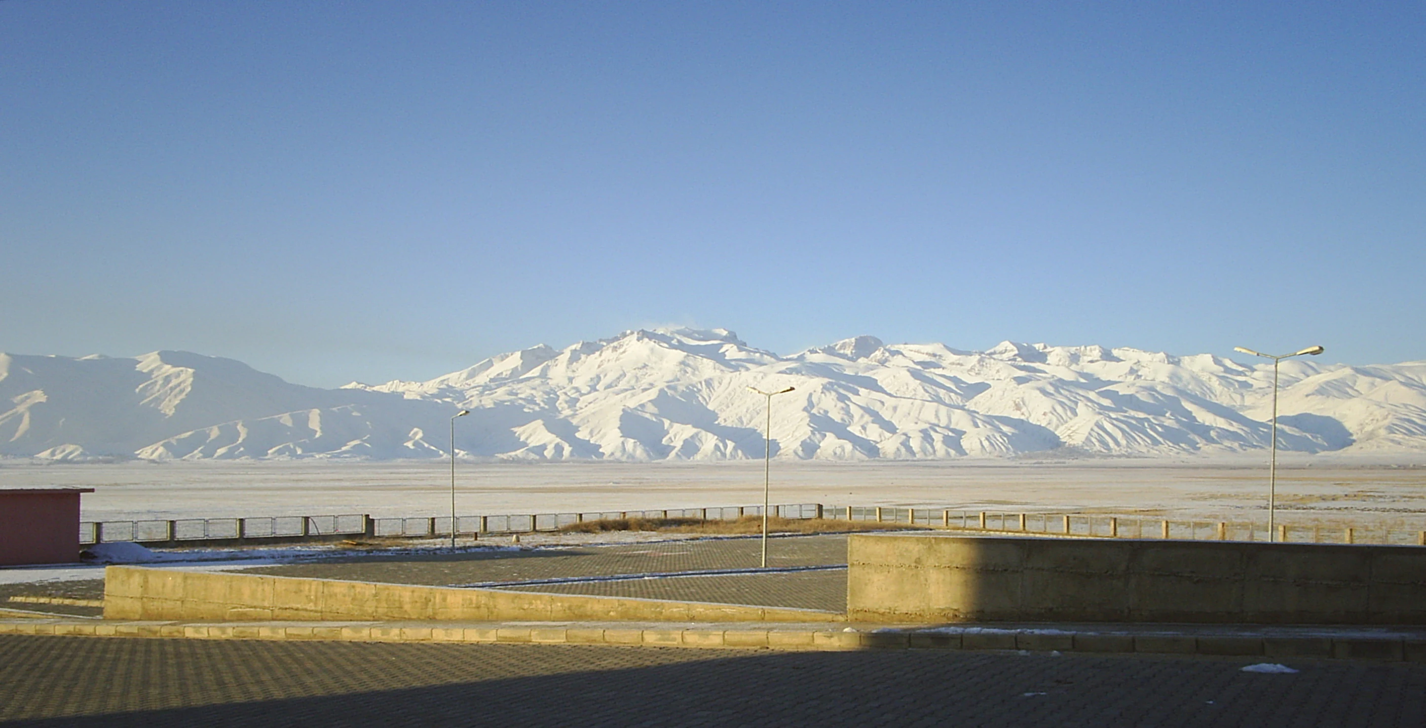
Wide landscape view of snow-covered mountain peaks under clear blue sky with a concrete structure and paved area in the foreground
Snow-capped mountains visible from a paved area with a low concrete structure in the foreground

Hakkari Cilo-Sat Mountains National Park history and protected-area timeline

The Cilo and Sat Mountains have long been a significant landscape in the Hakkari region, though the area remained without formal national protection until recently. The mountains were historically known as Buzul (Glacier) Mountains for the Cilo range and İkiyaka Mountains for the Sat range. The first documented ascent of Uludoruk peak was made in 1931 by mountaineers Ludwig Sperlich and Ludwig Krenek, marking the beginning of recorded exploration of these remote high-altitude terrain. The area remained relatively isolated due to both its remote location and security considerations that limited access for decades. In 2020, following preliminary work beginning in June of that year, the Turkish government designated the mountain range and its surroundings as a national park under the provisions of Article 3 of Law No. 2873 on National Parks. The protected area was formally established on September 26, 2020 (September 25 according to Turkish sources), becoming Turkey's 45th national park and one of the newest additions to the country's protected area network. The establishment reflected growing recognition of the area's outstanding universal values in terms of both biodiversity and geological significance.

Hakkari Cilo-Sat Mountains National Park landscape and geographic character

The park protects an extraordinary mountain landscape shaped by millions of years of glacial activity. The Cilo and Sat ranges rise dramatically from the surrounding terrain, with steep topography resulting from abrasion, cracking, and erosion caused by glacial processes and freeze-thaw cycles. Deep glacial valleys, extensive moraines, and the numerous glacial lakes scattered throughout the area provide visible evidence of the glaciation that began approximately two million years ago. The mountains remain actively glaciated, with the glaciers continuing to melt since their peak approximately twenty thousand years ago. In August 2023, a significant glacial collapse was observed in the Cennet-Cehennem region, with approximately 3,000 meters of glacier breaking apart, highlighting the ongoing dynamic processes shaping this landscape. The park extends roughly 60 kilometers in a northwest-southeast direction, encompassing not only the high peaks but also the Mergan Plateau at 2,400 meters elevation. Other significant peaks include Suppa Durek at 4,060 meters, Köşedireği Mountain at 3,700 meters, Kisara Mountain at 3,500 meters, Maunseli Sivrisi at 3,850 meters, and Gelyona Hill at 3,650 meters. The İnci Stream passes through the valley between the Cilo and Sat Mountains, fed by meltwater from the glaciers.
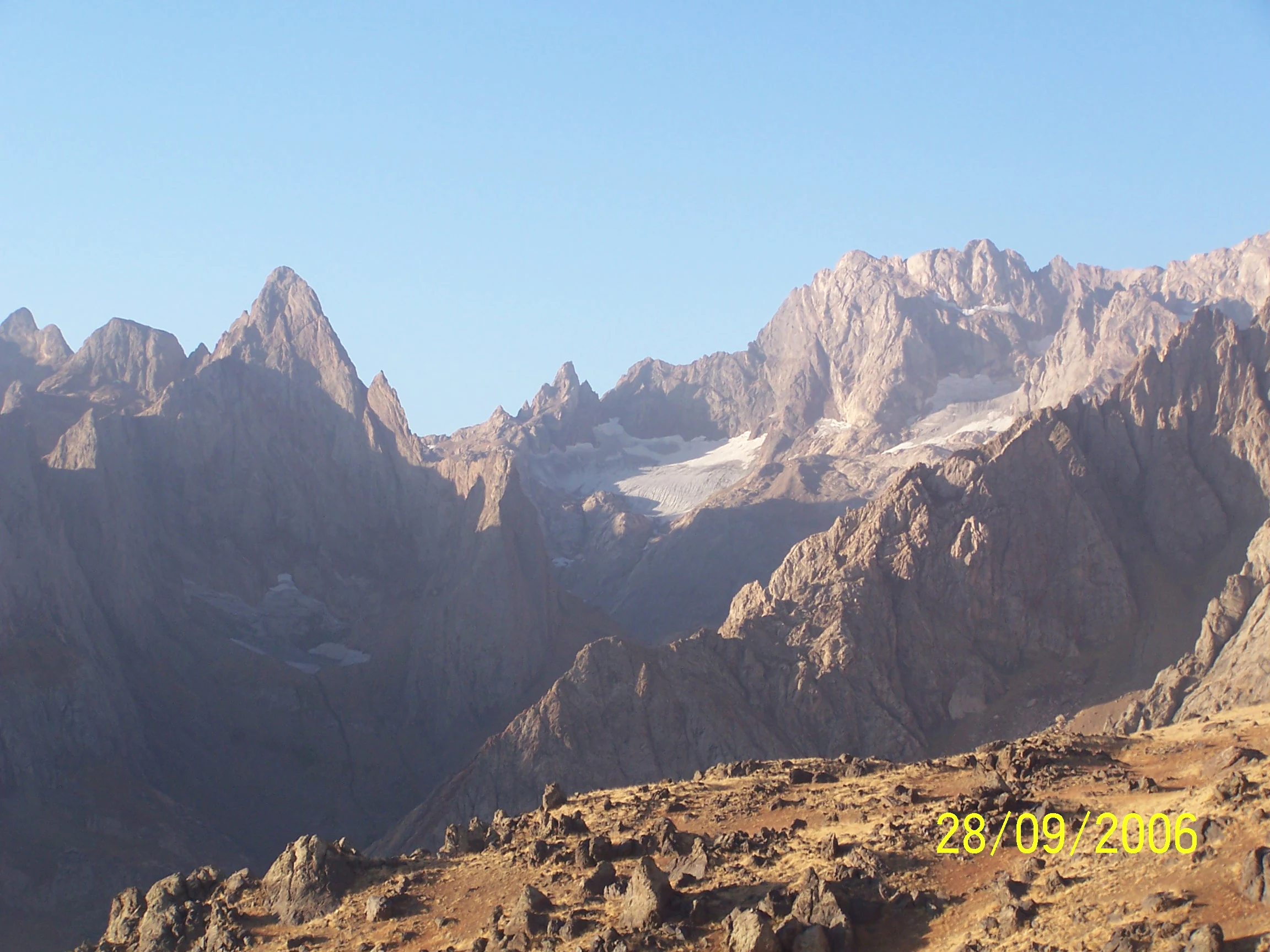
Panoramic mountain landscape showing rocky peaks with patches of snow under clear blue sky
Panoramic view of the Cilo Mountains with rocky peaks and patches of snow under clear blue sky

Hakkari Cilo-Sat Mountains National Park ecosystems, habitats, and plant life

The park supports a distinctive alpine ecosystem with remarkable biodiversity significance. The upper elevations feature extensive alpine meadows interspersed with stony terrain, creating habitat conditions that support numerous narrow-ranging and endangered plant species. The Cilo Mountains have been identified as one of the most important plant areas in both Turkey and globally, meeting criteria for designation as a Key Biodiversity Area. The protected area supports 53 plant taxa, including six endemic species found nowhere else on Earth. Two particularly notable endemics are Cephalaria hakkiarica and Cirsium hakkaricum, both named after the Hakkari region. At the highest elevations, permanent glaciers and glacial lakes dominate the landscape, particularly in the Sat Mountains area. The lower south-facing valleys contain remnants of oak forests and walnut communities, representing a different ecological zone within the park. This combination of diverse habitats from valley floors to permanent snowfields creates a complex ecological mosaic supporting significant biodiversity.

Hakkari Cilo-Sat Mountains National Park wildlife and species highlights

The mountainous area supports a rich diversity of animal species, with several species of particular conservation significance. The Lake Urmia newt (Neurergus crocatus), a striking amphibian species on the brink of extinction globally, finds sanctuary in this park. The wild goat (Capra aegagrus) inhabits the rocky terrain and steep cliffs, while the narrow-distributed Persian mole (Talpa davidiana) occupies the montane habitats. The area is particularly significant for invertebrates, with eleven butterfly taxa recorded, including four endemic species. The polyeyed Hakkari freckle (Polyommatus dezinus) is found only within this park's boundaries. Bird species breeding in the area include the golden eagle (Aquila chrysaetos), Eurasian griffon vulture (Gyps fulvus), and Caspian snowcock (Tetraogallus caspius), representing a notable assemblage of raptors and montane bird species. This combination of rare amphibians, distinctive mammals, endemic invertebrates, and significant bird populations makes the park an important wildlife conservation area.

Hakkari Cilo-Sat Mountains National Park conservation status and protection priorities

The establishment of Hakkari Cilo-Sat Mountains National Park represents a significant addition to Turkey's conservation estate, protecting an area of outstanding biodiversity and geological value. The mountain range meets Key Biodiversity Area criteria, reflecting its global significance for plant diversity with six endemic plant species. The park provides crucial protection for the endangered Lake Urmia newt, a species whose global range is extremely limited. The designation also preserves the geological heritage represented by the active glaciers, glacial valleys, and glacial lakes that document millions of years of Earth history. However, the conservation outlook faces challenges from ongoing climate change, as evidenced by the significant glacial retreat and collapse events observed in recent years. The melting glaciers, which have been receding since the last glacial maximum approximately twenty thousand years ago, may accelerate under current climate change scenarios, potentially bringing significant changes to the park's ecosystems. Security considerations have limited access to some parts of the park, which has inadvertently provided a form of protection, though it also restricts tourism and recreational use. The park is administered by the Directorate-General of Nature Protection and National Parks at the Ministry of Agriculture and Forestry.

Hakkari Cilo-Sat Mountains National Park cultural meaning and human context

The park landscape holds historical significance beyond its natural values, with evidence of human presence in the form of churches and rock paintings scattered throughout the area. These cultural features reflect the long history of human habitation and use of the high mountain environment in the Hakkari region. The local communities in the surrounding area have traditionally utilized the mountain pastures and high terrain, though access to the core park area has been restricted for security reasons. The remote location of the park in Turkey's southeastern region, near the borders with Iraq and Iran, has historically limited development and population pressure on the landscape. The park falls within the boundaries of multiple districts including Hakkari center, Şemdinli, and Yüksekova, reflecting its extent across the province.

Top sights and standout views in Hakkari Cilo-Sat Mountains National Park

The park's defining highlight is Uludoruk peak at 4,135 meters, Turkey's second-highest mountain, surrounded by an otherworldly landscape of active glaciers, glacial valleys, and alpine lakes. The combination of exceptional elevation, ongoing glacial activity, and endemic biodiversity makes this one of Turkey's most distinctive protected mountain environments. The presence of six endemic plant species, the endangered Lake Urmia newt, and significant populations of golden eagles and griffon vultures adds biological significance to the dramatic physical landscape. The Mergan Plateau and Avaspi Glaciers provide accessible points of interest within the park, while the challenging ascent of Uludoruk attracts experienced mountaineers during the summer season. The relatively recent establishment as a national park means this wilderness remains among Turkey's least-visited and most pristine mountain protected areas.

Best time to visit Hakkari Cilo-Sat Mountains National Park

The summer months from June through August offer the most favorable conditions for exploring the park, when temperatures at lower elevations are warm and the high mountain routes become accessible for mountaineering. The Uludoruk summit climb is typically attempted during this period by experienced climbers starting from the Serpil Plateau at the foot of Mount Cilo. However, visitors should be aware that the active glaciers pose risks, including the potential for sudden glacial calving and the formation of dangerous crevasses. The shoulder seasons of spring and autumn may offer different experiences with fewer visitors, though access and conditions become more challenging at higher elevations. Winter conditions are extreme, with heavy snowfall and very low temperatures limiting access to the high terrain. The park's remote location and security considerations mean that access routes can be restricted, and visitors should check current conditions before planning trips.
Monthly climate preview

Long term temperature trends and monthly precipitation averages modeled for high-elevation terrain

Hakkari Cilo-Sat Mountains National Park Climate Averages and Weather by Month

Modelled data at 2115 meters shows that Hakkari Cilo-Sat Mountains National Park undergoes severe winter freezing alongside dry, hot summers peaking in July and August. Exploring the full twelve-month profile provides precise historical averages for daily minimums, maximums, and precipitation cycles throughout the year.
Annual mean8 °C
-6 °C22 °C
Jan-6°
Feb-4°
Mar
Apr
May11°
Jun18°
Jul22°
Aug22°
Sep17°
Oct10°
Nov
Dec-3°
Warmest month
July

22.1 °C

Coolest month
January

-5.5 °C

Wettest month
April

1.9 mm/day

Driest month
August

0.1 mm/day

Park location guide

Geography guide, regional context, and park location map for Hakkari Cilo-Sat Mountains National Park

Hakkari Cilo-Sat Mountains National Park park geography, regions, and map view in Turkey

Understand where Hakkari Cilo-Sat Mountains National Park sits in Turkey through a broader geographic reading of the surrounding landscape, nearby location context, and its mapped position within the national park landscape.

How Hakkari Cilo-Sat Mountains National Park fits into Turkey

Turkey, officially the Republic of Türkiye, is a transcontinental country located mainly in Anatolia (West Asia) with a smaller portion in East Thrace (Southeast Europe). It borders the Black Sea to the north, several countries to the east and south, and the Aegean Sea and European countries to the west. The country has a population of over 86 million and operates as a secular, Muslim-majority presidential republic with Ankara as capital and Istanbul as its largest city.

Wider geography shaping Hakkari Cilo-Sat Mountains National Park in Turkey

Turkey is a transcontinental country with the majority of its territory (about 97%) located in Anatolia (West Asia) and a smaller portion called East Thrace in Southeast Europe. It borders the Black Sea to the north, Georgia, Armenia, Azerbaijan, and Iran to the east, Iraq and Syria to the south, and the Mediterranean Sea to the southwest. To the west, Turkey borders the Aegean Sea, Greece, and Bulgaria. The terrain includes mountains, plateaus, and coastal plains, with the Taurus Mountains running along the southern coast.

Map view of Hakkari Cilo-Sat Mountains National Park

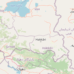
Use this park location map to pinpoint Hakkari Cilo-Sat Mountains National Park in Turkey, understand its exact geographic position, and read its mapped placement within the surrounding landscape more clearly.

Pigeon | © OpenStreetMap contributors

Location context for Hakkari Cilo-Sat Mountains National Park

Hakkari ProvinceYüksekova District
Natural feature types

Explore Named Landforms in Hakkari Cilo-Sat Mountains National Park

Examine the specific glacial, mountain, and aquatic features that define the topography of Hakkari Cilo-Sat Mountains National Park. MoriAtlas provides a clear geographic context for these natural landmarks, facilitating deeper insight into the protected landscape and its regional setting in Turkey.
Recorded earthquake history

Review the Seismic History of Hakkari Cilo-Sat Mountains National Park

Explore the historical collection of recorded seismic activity associated with the geography of Hakkari Cilo-Sat Mountains National Park. MoriAtlas provides a clear, structured view of documented earthquake events to support your understanding of regional seismic history surrounding this protected mountain landscape.

Hakkari Cilo-Sat Mountains National Park Earthquake History

Catalogued events

55 events

Strongest magnitude

Magnitude 5.9

Most recent event

Mar 11, 2025

This history includes earthquakes recorded inside the park or within 50 km of its borders

Visualize the dramatic glacial valleys, alpine meadows, and unique protected habitats of this striking mountain environment in Turkey.

Hakkari Cilo-Sat Mountains National Park Photos: Visualizing Glacial Peaks, Valleys, and Alpine Habitats

A gallery of Hakkari Cilo-Sat Mountains National Park photos offers deep insight into its dramatic glacial landscapes, towering peaks, and extensive alpine environments. Visually trace the sculpted terrain, observe unique high-altitude habitats, and understand the distinct character of this significant protected area in Turkey's eastern region.

Wide landscape view of snow-covered mountain peaks under clear blue sky with a concrete structure and paved area in the foreground

A large glacier surrounded by rocky mountain peaks with patches of snow

Panoramic mountain landscape showing rocky peaks with patches of snow under clear blue sky

Park atlas

Compare high-altitude mountain parks, glacial landscapes, and protected areas across Hakkari Province and the broader southeastern Anatolian region.

Browse Other National Parks and Protected Areas Near Hakkari Cilo-Sat Mountains National Park

Browse other national parks and protected areas, including high-altitude mountain environments and glacial landscapes, within Hakkari Province and the broader southeastern Anatolian region. This geographic overview helps you compare diverse protected lands and trace the regional spread of conservation efforts, providing valuable context for your atlas exploration.
Watercolor illustration showing a winding river through a valley with green hills and distant mountains
National parkSiirt Province
168 km away#1 closest

West

Botan Valley National Park: Turkey's Largest National Park with Extensive Valley Landscape

Mapped Protected Area in Siirt Province, Southeastern Anatolia

Botan Valley National Park stands as Turkey's most significant protected area, renowned for its vast size and rich biodiversity. Centered around the dramatic Botan River valley in Siirt Province, the park offers a unique glimpse into southeastern Anatolia's rugged geography and diverse ecosystems. This atlas-focused entry allows for exploration of the park's mapped boundaries, its distinctive river valley landscape, and its role in regional nature conservation efforts.

Area
486 km²
Established
2019
IUCN
II
Relief
Mixed relief
Watercolor illustration of a mountainous landscape with green fields, a river, and a sunset sky
National parkOrdubad District
About 244 km away#2 closest

Northeast

Zangezur National Park: National Park and Protected Mountain Wilderness in Ordubad District

Explore dramatic glacial terrain and the highest Lesser Caucasus peaks.

Zangezur National Park encompasses a significant portion of the Zangezur mountain range, presenting a striking high-altitude protected landscape within Ordubad District, Azerbaijan. Its geography is characterized by rugged alpine features, extensive glacial formations, and dramatic elevation changes culminating in the Gemiqaya summit. This park serves as a vital refuge for diverse ecosystems and is distinguished by its role in preserving the highest mountain terrain in Azerbaijan's Lesser Caucasus, offering a unique focal point for geographic and protected-area exploration.

Area
427.97 km²
Established
2003
IUCN
II
Relief
Mountain
Watercolor illustration showing mountains, green forests, and a winding river under a soft pink sky.
National parkSyunik Province
About 249 km away#3 closest

Northeast

Arevik National Park: Syunik Province's Protected Mountain Landscape and Biodiversity Atlas

Explore mapped boundaries, terrain, and ecosystems.

Arevik National Park offers a detailed look into the geography and protected landscape of Armenia's Syunik Province. This park is defined by the rugged Zangezur mountains and its remarkable vertical ecological zoning, transitioning from semi-desert to alpine environments. Examine its mapped terrain, significant butterfly and bird habitats, and the presence of key mammal species, providing a comprehensive atlas-style understanding of this protected area's natural identity.

Area
344 km²
Established
2009
IUCN
II
Relief
Mountain
Nature reserveSyunik Province
About 263 km away#4 closest

Northeast

Shikahogh State Reserve: Geographic Mapping and Protected Forest Territory Analysis

Exploring the mountain terrain and biodiversity of Syunik Province

Shikahogh State Reserve serves as a strictly protected forest sanctuary in southern Armenia, characterized by its complex vertical relief and transition between Caucasian forest and arid landscape elements. The reserve spans the upper basins of the Tsav and Shikahogh rivers, featuring a dense canopy and unique habitat for varied mountain fauna. This geographic overview highlights the reserve as a central feature of the Zangezur mountain ecology.

Area
103.3 km²
Established
1958
IUCN
Ia
Relief
Mountain
A horizontal watercolor illustration depicting rolling, sandy desert dunes in the foreground and light purple, hazy mountain silhouettes in the background against a white sky.
Wildlife reserveArarat Province
About 268 km away#5 closest

North

Goravan Sands Sanctuary: Protected Sandy Semi-Desert Ecosystems in Ararat Province

A rare relict landscape of Armenia's Caucasus biodiversity

Goravan Sands Sanctuary preserves a striking mosaic of sandy plains, dry limestone ridges, and tertiary clay habitats within the Ararat Province. Known for hosting the only known Armenian population of the relict phog shrub, this reserve is a reference site for psammophilic flora and endemic invertebrate fauna. Explore the layered geography and arid biodiversity of this high-priority South Caucasus conservation landscape.

Area
0.96 km²
Established
1959
Relief
Upland
Climate
Arid
Nature reserveZangilan District
About 274 km away#6 closest

Northeast

Basut-Chay State Reserve: Regional Geography and Protected Forest Landscape Atlas

Nature reserve in the Lesser Caucasus of Azerbaijan

Basut-Chay State Reserve protects a significant riverine landscape dominated by centuries-old Oriental plane trees. Located within the Zangilan District, the area showcases a compact ecological gradient featuring alluvial river terraces and steep mountain slopes. This strict nature reserve provides a essential reference for studying Caucasian floodplain forest remnants and mountain valley topography.

Area
1.07 km²
Established
1974
IUCN
Ia
Relief
Mountain
A horizontal watercolor painting depicting rolling green hills, distant mountains, and sparse vegetation.
Nature reserveArarat Province
277 km away#7 closest

North

Khosrov Forest State Reserve: Mapping Armenia's Historic Nature Reserve and Mountain Geography

Explore ancient juniper forests and rugged canyon terrain in Ararat Province.

Khosrov Forest State Reserve is a critical protected landscape in Armenia defined by its remarkable elevational gradient. From semi-desert lowlands to high mountain meadows, the reserve encompasses unique Tertiary relict forests and river-cut gorges. This resource maps the park's boundaries and provides a clear geographic overview of its diverse ecosystems and cultural heritage within the Ararat Province.

Area
232.13 km²
Established
1958
IUCN
Ia
Relief
Mountain
Nature reserveArmenia
About 296 km away#8 closest

North

Erebuni State Reserve: Protected Nature Reserve and Botanical Landmark in Armenia

Transitional mountain-steppe and semi-desert botanical geography

Erebuni State Reserve functions as a critical protected area for the conservation of wild wheat genetic resources in the South Caucasus. Located on the edge of the Armenian capital, the reserve protects a mosaic of grass-dominated slopes that capture the precise shift from arid lowlands to higher altitude steppe terrain, providing an essential focus for regional botanical study.

Area
1.2 km²
Established
1981
IUCN
Ia
Relief
Upland

Common questions about visiting, size, designation, and location context for Hakkari Cilo-Sat Mountains National Park

Hakkari Cilo-Sat Mountains National Park FAQs for park facts, access, geography, and protected area context

Find quick answers about Hakkari Cilo-Sat Mountains National Park, including protected-area facts, park geography, trail and visitor context, and how the park fits into its surrounding country and regional landscape.
MoriAtlas Explorer

Continue Your Protected Areas Search Across the Global Atlas

Deepen your exploration by continuing the structured search for national parks and protected areas worldwide. Utilize the comprehensive filtering capabilities to compare different conservation landscapes and refine your understanding of global park geography. Discover more about the distribution and characteristics of protected natural areas.

Global natural geography