
Streams
Park geography
Structured map data for one of the most prominent volcanic landscapes in Hawaii.
Haleakalā National Park Geographic Profile: Boundaries, Terrain, and Natural Features
This geographic profile provides a detailed overview of Haleakalā National Park located in Maui County, Hawaii. Access precise boundary measurements, elevation data reaching 3055 meters, and a comprehensive list of internal natural features ranging from volcanic cinder cones to coastal waterfalls.
Related tags
volcanic landscapeendemic speciesHawaiian ecosystemssilverswordnational park
Hawaiian volcanic wilderness protecting endangered silversword and unique ecosystems
Haleakalā National Park
Haleakalā National Park occupies the summit of the dormant Haleakalā volcano on the island of Maui, Hawaii. The park spans approximately 33,265 acres, of which nearly 25,000 acres are designated as wilderness, making it one of the most significant protected areas in the Hawaiian Islands. The name Haleakalā translates from Hawaiian as "house of the sun," referencing a legendary tale in which the demigod Maui imprisoned the sun on the mountain to lengthen the day. The park encompasses two distinct sections: the summit area with its dramatic crater landscape and the coastal Kipahulu region with its waterfalls and pools. Established as a separate national park in 1961, it was designated an International Biosphere Reserve in 1980 and contains more endangered species than any other national park in the United States.
- Location
- United States of America
- Park type
- National park
- Established
- 1961
- Area
- 134.6 km²
- Highest point
- 3,055 m
Location overview
Territorial alignment within Maui County and the wider Hawaii region
Geographic Location and Setting of Haleakalā National Park
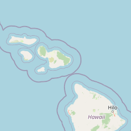
Haleakalā National Park is located within the United States of America, situated in the region of Hawaii and Maui County. Official geographic records identify the protected territory as both a coastal park and an island park.
- Countries
- United States of America
- Regions
- Hawaii, Maui County
- Primary location
- Maui County
- Geographic setting
- Coastal · Island
Boundary and coordinates
Mapping the spatial footprint and coordinate span across the island terrain
Spatial Boundaries and Geographic Map of Haleakalā National Park
Geographic boundary mapping traces the physical footprint of Haleakalā National Park for spatial context. Complementary metrics record the estimated area of 134.62 square kilometers along with coordinate limits.
- Boundary area
- 136.6 km²
- Boundary perimeter
- 90.4 km
- Northernmost point
- 20.7724° N
- Southernmost point
- 20.6261° N
- Easternmost point
- 156.0405° W
- Westernmost point
- 156.2567° W
- Geographic centre
- 20.7072° N, 156.1594° W
- North–south span
- 16.2 km
- East–west span
- 22.5 km
Elevation and terrain
Mountain relief metrics, peak elevations, and recorded geographic features
Haleakalā National Park Terrain, Elevation, and Mapped Natural Features
Recorded elevation data outlines the mountain terrain profile and highest summit within Haleakalā National Park. Structured feature cards detail individual peaks, streams, and viewpoints located inside the protected area.
- Maximum elevation
- 3,055 m
- Highest point
- 3,055 m
Selected named natural features
Streams
Honomanū Stream
Peaks
Haupaʻakea Peak
2,788 m
Peaks
ʻŌʻilipuʻu
2,099 m
Peaks
Honokahua
2,197 m
Viewpoints
Leleiwi Overlook
Environmental setting
Recorded tropical climate zones, mountain relief, and habitat types across the terrain
Environmental Classifications and Physical Setting of Haleakalā National Park
Recorded landscape features, tropical habitat types, and mountain relief classifications form complementary categories for reading the physical setting of Haleakalā National Park. Connected atlas destinations link these broader environmental designations to related protected areas and regional geographies.
- Relief
- Mountain
- Climate
- Tropical
- Water
- Major water bodies
- Forest cover
- Mostly forested
Landscape features
Mountains · Valleys · Hills · Forest · Rivers · Waterfalls · Coast · Islands · Volcano
Habitat types
Tropical forest · Shrubland · Alpine meadow · Coastal habitat
Park atlas
Compare surrounding protected landscapes and map the regional spread of parks across the Hawaiian Islands.
Discover Other National Parks and Protected Areas Near Haleakalā National Park
Continue your park discovery beyond Haleakalā National Park by browsing other national parks and protected natural areas across the Hawaiian Islands, tracing their diverse terrains and conservation landscapes. Use this geographic overview to compare unique volcanic features, diverse ecosystems, and regional protected area spreads, gaining a deeper atlas perspective.
Marine protected areaHawaii
20 km away#1 closest
West

Hawaiian Islands Humpback Whale National Marine Sanctuary Geographic and Protected Area Map
Explore marine boundaries and reef ecosystems in the Hawaii archipelago.
The Hawaiian Islands Humpback Whale National Marine Sanctuary provides essential protection for vast underwater habitats stretching across the Hawaiian archipelago. This protected area supports a specialized ecosystem featuring diverse coral reefs and significant whale breeding grounds. Understanding the sanctuary requires examining its unique spatial gradient from shallow shorelines to deep oceanic waters and its role in regional conservation.
- Area
- 3,626 km²
- Established
- 1992
- IUCN
- IV
- Access
- Easy access
National parkUnited States of America
133 km away#2 closest
Southeast
Hawaiʻi Volcanoes National Park: National Park Geographic Atlas and Protected Landscape
Mapped volcanic terrain and regional protected area context.
Delve into the geographic identity of Hawaiʻi Volcanoes National Park, a notable protected area within the United States of America. This park offers unique volcanic landscapes and provides an invaluable resource for understanding mapped terrain, regional geography, and the specific boundaries of conservation lands. Explore its distinct environmental features and discover its significance through a detailed atlas-oriented lens.
- Area
- 1,434.45 km²
- Established
- 1916
- IUCN
- II
- Visitors
- 1.4M annual
Marine protected areaHawaii
About 1,550 km away#3 closest
Northwest
Papahānaumokuākea Marine National Monument: Mapped Geography and Protected Pacific Seas
A sprawling marine reserve spanning Northwestern Hawaiian islands and atolls.
Papahānaumokuākea Marine National Monument covers a vast expanse of the Pacific, including coral reefs, submerged banks, and ten islands and atolls. This protected area offers significant insights into remote oceanic geography, featuring critical habitats for endemic species and layered maritime historical sites. Explore the structural map and landscape composition of this immense marine protected zone.
- Area
- 1,508,870 km²
- Established
- 2006
- Relief
- Lowland
- Climate
- Tropical

Marine protected areaCalifornia
3,615 km away#4 closest
Northeast
Monterey Bay National Marine Sanctuary: California Marine Protected Area and Coastal Atlas
Mapping deep submarine canyons and expansive Pacific coastal ecosystems.
Monterey Bay National Marine Sanctuary represents one of the most biologically significant marine protected areas in the United States. Spanning 276 miles of California shoreline, the sanctuary encompasses varied aquatic terrain including towering kelp forests, rocky reefs, and the massive Monterey Submarine Canyon. This protected marine landscape serves as a crucial region for oceanic research and environmental conservation.
- Area
- 15,780 km²
- Established
- 1992
- Relief
- Mixed relief
- Climate
- Mediterranean
Marine protected areaCalifornia
3,638 km away#5 closest
Northeast
Cordell Bank National Marine Sanctuary: Geographic Atlas and Marine Protected Area Context
Submerged granite seamount and offshore California marine ecosystem
Cordell Bank National Marine Sanctuary is an expansive protected marine zone situated off the California coast. The sanctuary preserves a rare granite underwater mountain that acts as a biodiversity hotspot. Learn about the submerged terrain, continental shelf boundaries, and ecological importance of this significant North American marine conservation area.
- Area
- 3,330 km²
- Established
- 1989
- Relief
- Lowland
- Climate
- Mediterranean
Marine protected areaCalifornia
3,641 km away#6 closest
Northeast
Greater Farallones National Marine Sanctuary: Protected Marine Geography and Atlas Data
Essential marine protected area off the coast of California.
Greater Farallones National Marine Sanctuary protects a vital network of oceanic habitats off California, including sandy beaches, tidal flats, subtidal reefs, and open ocean waters. This marine protected area serves as a critical link in the Pacific coast's network of conservation landscapes, offering a deep look at the geographic connectivity between coastal estuaries and offshore continental shelf environments.
- Area
- 8,530 km²
- Established
- 1981
- Relief
- Lowland
- Climate
- Mediterranean
Protected areaMarshall Islands
About 3,701 km away#7 closest
West

Bikar Atoll Protected Area: Geographic Overview of a Remote Marshall Islands Coral Atoll
A pristine, uninhabited coral sanctuary and critical Pacific marine habitat.
Bikar Atoll is a remote, diamond-shaped coral ring located in the Ratak Chain of the Marshall Islands. Defined by its shallow lagoon, continuous reef structure, and arid islets, the atoll serves as a vital nesting site for seabirds and green turtles. This protected area remains one of the most ecologically undisturbed sites in the Pacific, offering rare insight into natural atoll morphology and island conservation.
- Area
- 0.5 km²
- Established
- 2025
- Relief
- Lowland
- Climate
- Tropical
Marine protected areaCalifornia
3,704 km away#8 closest
Northeast
Chumash Heritage National Marine Sanctuary: California Marine Protected Area Atlas
Mapping coastal transition zones and submarine seafloor features
Spanning over 4,500 square miles off the Central Coast of California, the Chumash Heritage National Marine Sanctuary represents a critical ecological intersection between northern and southern marine species. The sanctuary includes dramatic underwater terrain like Arguello Canyon, Rodriguez Seamount, and the Santa Lucia Bank, creating a complex habitat that sustains kelp forests and diverse maritime resources.
- Area
- 11,770 km²
- Established
- 2024
- IUCN
- V
- Relief
- Mixed relief
MoriAtlas Explorer
Continue Exploring Haleakalā National Park's Protected Landscape and Regional Geography
Delve deeper into the protected-area specifics and geographic context of Haleakalā National Park. Understanding this park's unique landscape and mapped boundaries within Maui County enriches your atlas exploration and appreciation of its natural terrain. Continue your discovery journey to grasp its full significance in the regional geography and protected lands framework.
Browse next
Global natural geography
Explore related park routes
Explore MoriAtlas Global ParksBrowse All MoriAtlas ParksGlobal Park Map DiscoveryMoriAtlas: Browse All CountriesBrowse All MoriAtlas ContinentsNational Park Environment AtlasGrand Canyon National Park AtlasYellowstone National Park AtlasYosemite National Park Atlas and GeographySerengeti National Park AtlasGalápagos National Park Protected LandscapeBanff National Park Geography and AtlasKruger National Park Atlas EntryUluṟu-Kata Tjuṯa National Park AtlasExplore Uluru-Kata Tjuta National Park GeographyPlitvice Lakes National Park AtlasFiordland National Park Protected LandscapeGreat Smoky Mountains National Park AtlasAfghanistan National Parks and Protected AreasAlbania National Parks and Protected AreasAlgeria National Parks and Protected AreasAmerican Samoa National Parks and Protected AreasAndorra National Parks and Protected AreasAngola National Parks and Protected AreasAntarctica National Parks and Protected AreasAntigua and Barbuda Park List