
Mori Atlas logo
Wildlife reserveHato El Cedral

A comprehensive look at the seasonal savanna terrain, riverine geography, and protected landscape boundaries.

Hato El Cedral Wildlife Reserve: Mapping the Protected Wetlands of the Apure Llanos

Hato El Cedral represents a significant protected wildlife sanctuary within the expansive Llanos region of southwestern Venezuela. Spanning diverse ecosystems from gallery forests and morichales to seasonally flooded grasslands, this reserve offers a unique study in the hydrological rhythms of the Orinoco basin. Through our mapping of its vast, flat terrain and river systems, users gain insight into the ecological character of one of the country's most vital protected landscapes.

llanosVenezuelan plainsseasonal wetlandswetland sanctuarywildlife reserveecotourism
A flat-style digital illustration depicting a valley with steep rocky cliffs on both sides, a flowing river in the foreground, evergreen trees, and a waterfall cascading down the cliff face on the right.

Hato El Cedral

Wildlife reserve

Park overview

Structured park overview, official facts, and landscape profile for Hato El Cedral

Hato El Cedral park facts, protected area profile, and essential visitor context

Review the core facts for Hato El Cedral, including designation, size, terrain, visitor scale, habitats, and operating context in one park-focused overview.

About Hato El Cedral

Hato El Cedral occupies a strategic position in the western Venezuelan Llanos, within the alluvial plains that stretch between the Andes and the Orinoco River system. Its roughly 53,000-hectare footprint encompasses wide-open savannas, slow-moving rivers, oxbow lakes, flooded palm woodlands, and patches of higher ground, all of which shift dramatically between the wet and dry seasons. The estate's blend of natural and cultural landscape produces a setting in which cattle heritage, regional history, and wildlife conservation coexist across the same terrain.

The property functions simultaneously as a working cattle ranch, a protected wildlife reserve, and an eco-tourism destination. Its protected areas include the Santuario de Fauna de Matiyure, providing formal recognition for the site's role in safeguarding representative llanos ecosystems and the species that depend on them. Visitor infrastructure, including camps, observation towers, and boat transport, allows guests to move through habitats that range from open grassland to dense morichales and river edges, dramatically expanding the range of wildlife encounters available in a single visit.

As part of a broader Apure tourism circuit that includes Parque Nacional Santos Luzardo and Parque Nacional Río Viejo-San Camilo, Hato El Cedral has become a benchmark for how traditional livestock estates in Venezuela can be reinvented as conservation and ecotourism landmarks. Its combination of size, ecological diversity, management history, and literary association gives it a distinctive identity that few other llanos properties can match.

Quick facts and research context for Hato El Cedral

Hato El Cedral sits roughly 700 kilometers south of Caracas in the Llanos of Apure State, Venezuela, and spans approximately 53,000 hectares of seasonally flooded plains, rivers, and morichales. The site combines a centuries-old cattle hacienda landscape with formally protected wildlife habitat, including the Santuario de Fauna de Matiyure. Surveys have documented around 347 bird species and 89 mammal species, alongside notable reptile and amphibian diversity, reinforcing its standing as one of the foremost wildlife viewing areas in northern South America.

Protection and recognition

Explore terrestrial protection history and management scope details

Hato El Cedral Protection Status and Official Designation Record

Terrestrial protection status for Hato El Cedral is recorded alongside designation history established in 2008. Structured conservation records provide verifiable administrative framing for the managed landscape.

Protection details

Protection scope
Terrestrial
Designated year
2008
Transboundary protection
No
Park context

Deeper park guide and search-rich context for Hato El Cedral

Hato El Cedral history, landscape, wildlife, and travel context

Explore Hato El Cedral through its history, landscape character, ecosystems, wildlife, conservation priorities, cultural context, and seasonal travel timing in a structured park guide built for atlas discovery and search intent.

Why Hato El Cedral stands out

Hato El Cedral is best known as a premier llanos wildlife sanctuary where visitors can observe anacondas, caimans, capybaras, howler monkeys, and hundreds of bird species against the backdrop of vast seasonally flooded plains. It is equally celebrated for blending this extraordinary biodiversity with a deep ranching heritage, and for being associated with the landscape that inspired Rómulo Gallegos' novel Doña Bárbara. The combination of ecological richness, cultural resonance, and accessible wildlife viewing makes the property a defining icon of Venezuela's Llanos tourism circuit.
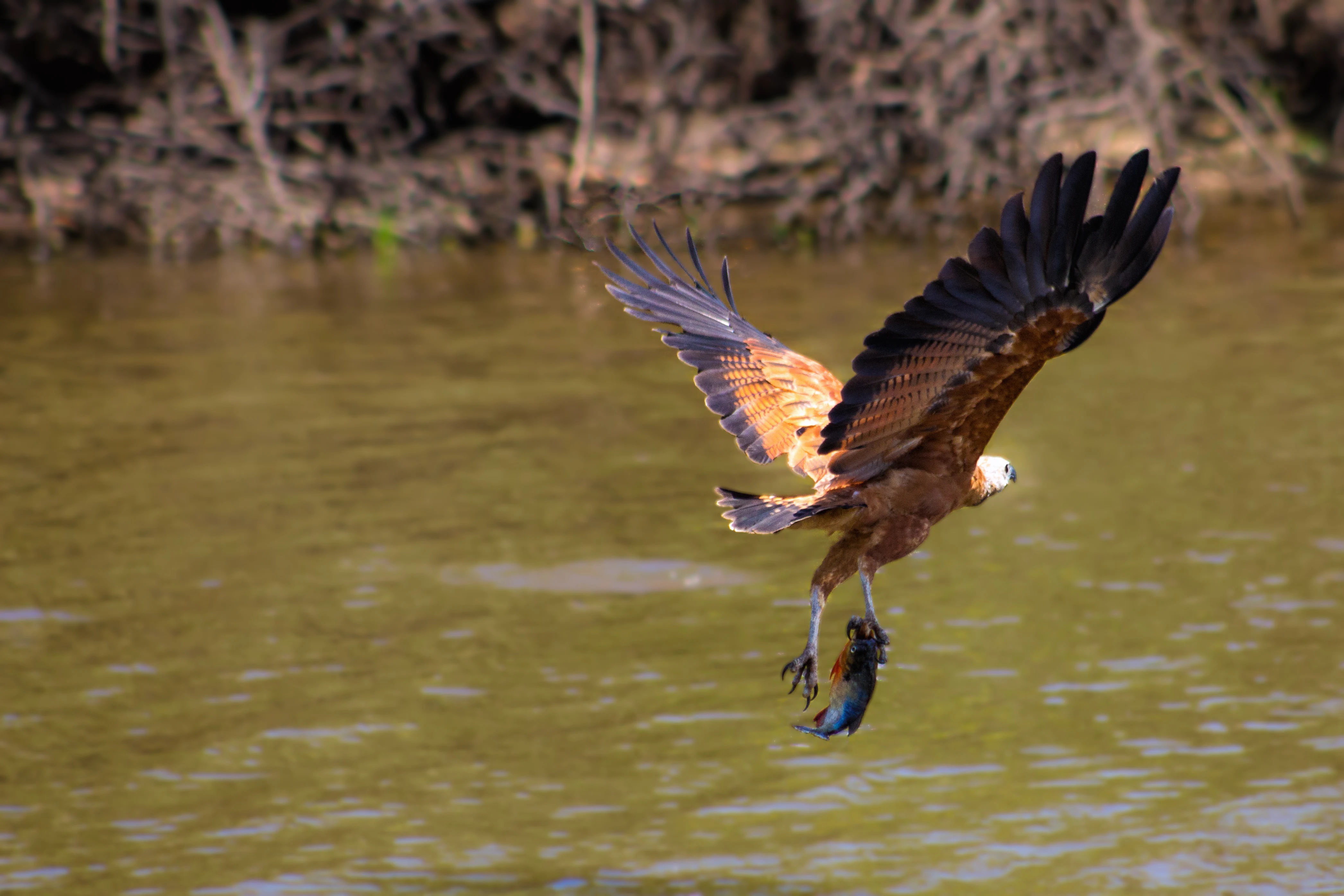
A black-collared hawk with brown plumage and a white head in flight over murky water, carrying a fish in its talons.
A black-collared hawk in flight, captured while carrying prey over the wetlands of Hato El Cedral.

Hato El Cedral history and protected-area timeline

The region around Hato El Cedral was colonized by the Spanish, with the small settlement of San Miguel de Mantecal de Caicara founded in the late 1780s. During the early nineteenth century the area was associated with Captain Pablo Ponte, who joined the patriot forces of General José Antonio Páez during Venezuela's war of independence against Spain.

The estate itself has been used for cattle ranching since the nineteenth century, passing through multiple owners and once operating under the earlier name Hato La Trinidad de Arauca. It is widely believed that this landscape partially inspired Rómulo Gallegos when he wrote his landmark 1929 novel Doña Bárbara, a work that shaped the global literary image of the Venezuelan Llanos.

Although the property remained in private hands for many years, portions of it were progressively protected, including recognition as the Santuario de Fauna de Matiyure. The hacienda opened to visitors in November 1987 after acquisition by Confederación Venezolana de Ganaderos, and in 2008 the Venezuelan state purchased the property outright. Today the state manages the reserve while granting eco-tourism concessions to private operators, securing both its conservation future and its continued role as a leading regional destination.

Hato El Cedral landscape and geographic character

The landscape of Hato El Cedral is defined by the flat, expansive llanos terrain typical of southwestern Venezuela, where seemingly endless plains meet slow rivers, morichales, and seasonally flooded lowlands. The Caicara, Orichuna, and Matiyure rivers, along with smaller streams, carve across the estate and give rise to extensive wetland areas whose extent varies dramatically with the seasons.

In the dry months the terrain hardens into open savanna dotted with scattered trees, while during the wet season large portions of the property transform into broad lagoons and flooded grasslands. Visitor infrastructure, including camps, lookouts, and miradores, is positioned to take advantage of this seasonal rhythm, providing elevated vantage points over water bodies where wildlife congregates as the dry season progresses.

The presence of moriche palm corridors and gallery forest along the waterways adds structural diversity to an otherwise flat landscape. The interplay of open plain, palm swamp, riverine forest, and reflective floodwater creates the varied scenery that has come to define the Venezuelan Llanos experience at El Cedral.
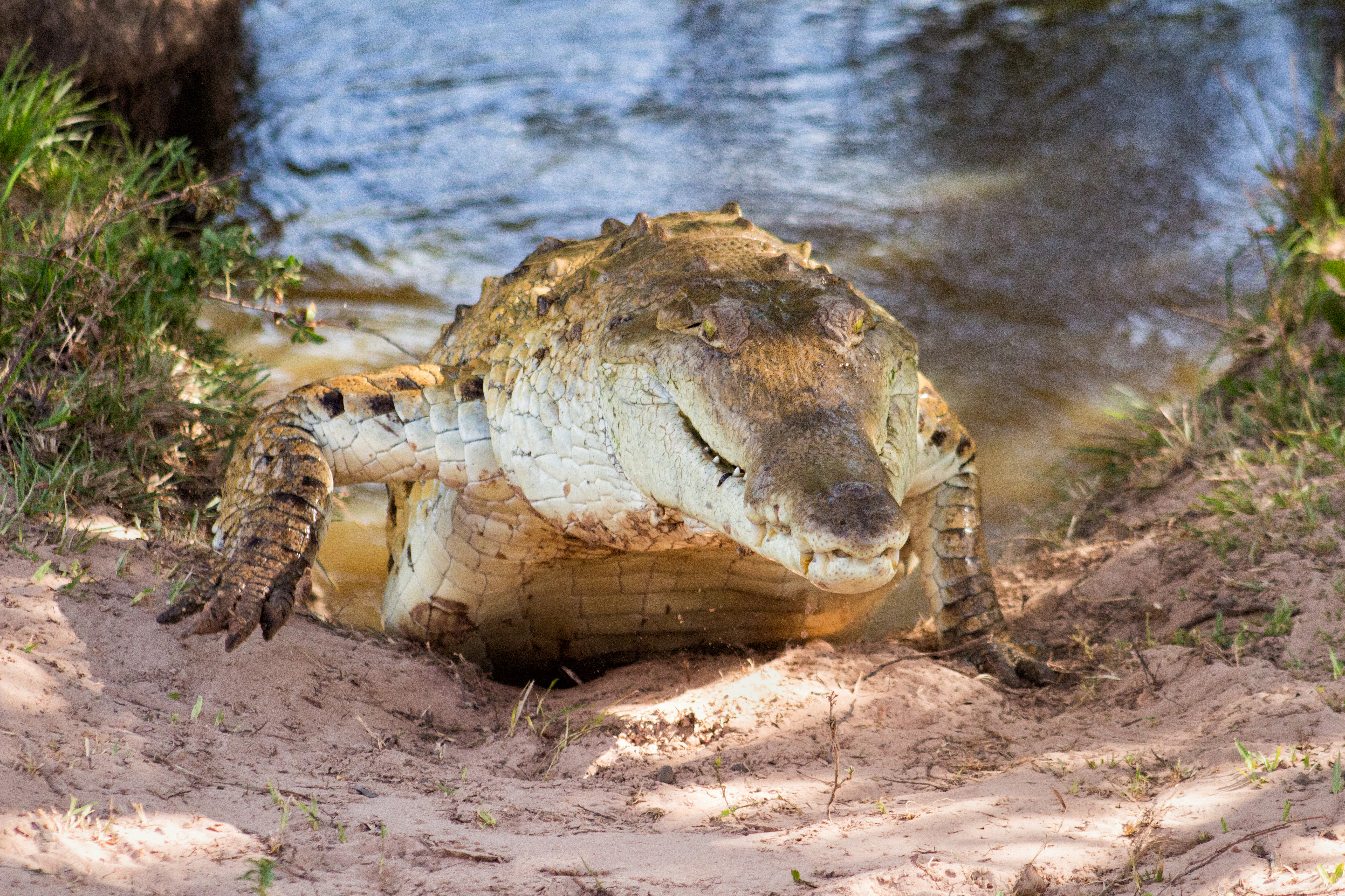
A large Orinoco crocodile resting on a sandy bank partially emerging from shallow water.
An Orinoco crocodile resting near the water's edge at Hato El Cedral.

Hato El Cedral ecosystems, habitats, and plant life

The ecosystems protected within Hato El Cedral span the full range of central llanos habitats, including seasonally flooded savanna, riverine forest, morichales, oxbow lagoons, and patches of higher woodland. This habitat diversity supports a remarkably rich biological community that includes specialized wetland species, savanna dwellers, primates, reptiles, amphibians, and one of the most diverse bird communities documented in Venezuela.

Conservation efforts at the site emphasize the maintenance of natural flooding cycles, the protection of riparian corridors along the principal rivers, and the safeguarding of gallery forests and morichales that function as critical refuge habitat during the dry season. The integration of working ranch land with formally protected zones, including the Santuario de Fauna de Matiyure, allows large landscape processes to continue operating across property boundaries.

Through its size and habitat heterogeneity, Hato El Cedral functions as an ecological anchor for the broader Apure llanos, supporting wildlife dispersal between neighboring protected areas such as Parque Nacional Santos Luzardo and Parque Nacional Río Viejo-San Camilo and contributing to the long-term viability of the regional ecosystem.
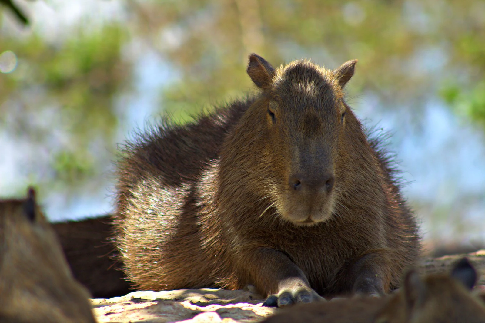
A close-up shot of a capybara resting on the ground with its head facing forward, positioned in a natural environment with blurred green and blue tones in the background.
A capybara resting in the sun, a common sight in the wetlands of Hato El Cedral.

Hato El Cedral wildlife and species highlights

Hato El Cedral hosts an exceptional concentration of characteristic llanos wildlife, with surveys documenting approximately 347 bird species, 89 mammal species, 62 reptile species, and 22 amphibian species. Among its most iconic residents are large groups of capybaras, the world's largest rodents, alongside howler monkeys whose calls echo across the gallery forests. The property is especially famous for its reptiles, including the Orinoco crocodile and green anacondas, the latter among the largest snakes recorded in Venezuela.

Birdwatching is a core attraction, with species such as the Black-collared Hawk frequenting the waterways and a long list of waders, raptors, and tropical lowland specialties filling the surrounding savannas and morichales. Mammal viewing often includes anteaters and foxes encountered on nocturnal guided excursions, while caiman, turtles, and a variety of fish populate the rivers and lagoons.

The combination of habituated wildlife, multiple habitat types, and guided viewing approaches allows visitors to encounter species that are difficult to see elsewhere in Venezuela. This richness has cemented Hato El Cedral as a flagship llanos wildlife destination and an important reference site for understanding the biodiversity of the Orinoco basin.
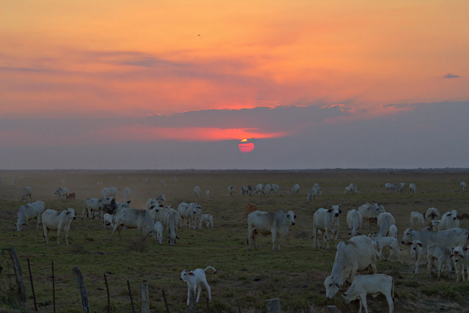
A wide, flat grassland landscape at sunset with a large herd of cattle grazing in the foreground and a warm, orange-toned sky.
A sunset view over the wetlands and cattle of the Venezuelan Llanos.

Hato El Cedral conservation status and protection priorities

Hato El Cedral plays an outsized role in the conservation of the Venezuelan Llanos, protecting a continuous block of seasonal wetlands, savanna, and riverine habitat at a scale rarely matched by purely protected-area reserves. The inclusion of the Santuario de Fauna de Matiyure within its boundaries gives formal protection status to some of the most ecologically sensitive portions of the property, particularly the wetlands and riparian corridors that sustain the largest concentrations of waterbirds, caimans, and other aquatic species.

The 2008 acquisition of the hacienda by the Venezuelan state marked a turning point, replacing fragmented private protection with centralized administration while still allowing private eco-tourism concessions to operate. This hybrid model has been central to ongoing initiatives in wildlife management, habitat restoration, and environmental education, leveraging tourism revenue to fund monitoring and protection programs on the ground.

By maintaining large-scale ecological processes such as wet and dry season flooding regimes, the reserve supports the long-term viability of species that depend on the full annual cycle of the llanos. Its ecological connectivity with neighboring national parks further strengthens its role as a conservation cornerstone of the Apure region and the broader Orinoco Llanos landscape.

Hato El Cedral cultural meaning and human context

Hato El Cedral sits at the heart of the traditional Venezuelan llanero culture that has shaped Apure for centuries. The estate's origins as a nineteenth-century cattle hacienda connect it directly to the ranching heritage of Los Llanos, a region defined by its horsemen, cattle drives, and distinctive identity within Venezuelan history. The landscape and rhythms of life at properties like El Cedral provided the cultural material that would later be immortalized in literature, most famously through Rómulo Gallegos and the novel Doña Bárbara.

The transition of the property from a privately operated ranch into a state-administered wildlife reserve with eco-tourism concessions reflects broader shifts in how the Llanos are valued, moving from a frontier of extraction toward a landscape recognized for its ecological and cultural heritage. The continued presence of llanero traditions, including horseback riding, working cattle, and local hospitality, means that visitors experience not only wildlife but also an enduring rural way of life that has helped define the cultural meaning of the Venezuelan plains.

Top sights and standout views in Hato El Cedral

Among its standout qualities, Hato El Cedral offers what few other destinations can: an enormous private-estate scale of habitat combined with regular sightings of anacondas, caimans, capybaras, and howler monkeys within a single trip. Its approximately 53,000-hectare footprint spans the full seasonal cycle of the Llanos, allowing visitors to experience the dramatic transformation from flooded savanna to dry-season wildlife congregations.

The reserve's long bird list, anchored by hundreds of documented species and enhanced by accessible observation points along rivers and lagoons, makes it an exceptional choice for birdwatchers. Pairing this natural richness with literary heritage tied to Doña Bárbara and a working cattle ranch legacy gives the property a uniquely Venezuelan character that blends ecology, history, and regional identity into one cohesive experience.

Best time to visit Hato El Cedral

Wildlife viewing at Hato El Cedral is shaped by the strong contrast between Venezuela's rainy and dry seasons, with the dry season widely regarded as the most rewarding period for animal sightings. As floodwaters recede, wildlife concentrates around the remaining rivers, lagoons, and waterholes, producing some of the densest concentrations of caimans, capybaras, wading birds, and other species found anywhere in the Llanos.

The wet season, by contrast, transforms the property into a vast flooded landscape where many animals disperse across wider areas and boat-based exploration becomes especially appealing. Visiting during transitional periods can offer a balance of lush green scenery and improving animal visibility, while dry-season visits emphasize close-range encounters in more compressed habitats. Travelers prioritizing wildlife photography, reptile viewing, and dense animal aggregations typically favor the dry months, while those interested in flooded plains scenery often choose the rainy period.
Monthly climate preview

Long-term representative point measurements for monthly weather patterns in Apure

Hato El Cedral Climate Normals, Annual Temperature and Precipitation Rhythm

Historical climatology data reveals measured monthly averages for temperature and precipitation across representative coordinates at Hato El Cedral. Examining the complete twelve-month record provides precise analytical depth for regional temperature ranges and rainfall distribution.
Annual mean28 °C
26 °C31 °C
Jan29°
Feb31°
Mar31°
Apr29°
May27°
Jun26°
Jul26°
Aug26°
Sep27°
Oct27°
Nov27°
Dec28°
Warmest month
March

31.3 °C

Coolest month
July

25.7 °C

Wettest month
June

9.6 mm/day

Driest month
January

0.3 mm/day

Park location guide

Geography guide, regional context, and park location map for Hato El Cedral

Hato El Cedral park geography, regions, and map view in Venezuela

Understand where Hato El Cedral sits in Venezuela through a broader geographic reading of the surrounding landscape, nearby location context, and its mapped position within the national park landscape.

How Hato El Cedral fits into Venezuela

Venezuela is a country in northern South America with coastline along the Caribbean Sea and Atlantic Ocean. It borders Colombia, Brazil, Guyana, and Trinidad and Tobago. The country has an area of approximately 916,445 km² and a population of about 31.8 million. Caracas is the capital and largest city. Venezuela consists of 23 states and the Capital District.

Wider geography shaping Hato El Cedral in Venezuela

Venezuela is located on the northern coast of South America. The continental territory is bordered by the Caribbean Sea and Atlantic Ocean to the north, Colombia to the west, Brazil to the south, and Guyana to the east. Trinidad and Tobago lies to the northeast. The country includes various islands and islets in the Caribbean Sea known as the Federal Dependencies.

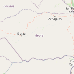
Map view of Hato El Cedral

Use this park location map to pinpoint Hato El Cedral in Venezuela, understand its exact geographic position, and read its mapped placement within the surrounding landscape more clearly.

Pigeon | © OpenStreetMap contributors

Location context for Hato El Cedral

Apure

Explore photographic records of seasonal wetlands, savanna habitats, and riverine forests across the protected reserve.

Hato El Cedral Photos and Landscape Scenery: Visualizing the Llanos Wildlife Sanctuary

Visual documentation captures the flat seasonal wetlands, open savannas, and gallery forests that define the protected landscape of Hato El Cedral. Examining these field photographs provides a clearer understanding of the terrain, water levels, and wildlife habitats found throughout the Venezuelan plains.

A black-collared hawk with brown plumage and a white head in flight over murky water, carrying a fish in its talons.

A large green anaconda with its mouth partially open, resting among dense green aquatic vegetation on wet soil.

A large Orinoco crocodile resting on a sandy bank partially emerging from shallow water.

A close-up shot of a capybara resting on the ground with its head facing forward, positioned in a natural environment with blurred green and blue tones in the background.

A wide, flat grassland landscape at sunset with a large herd of cattle grazing in the foreground and a warm, orange-toned sky.

Park atlas

Compare adjacent wetland reserves and regional conservation areas across the llanos basin

Explore Other Parks Near Hato El Cedral and Surrounding Protected Wetland Landscapes

Browse nearby national parks and protected areas sharing the distinctive seasonal floodplains and riverine habitats of Hato El Cedral. Evaluating surrounding regional geography provides deeper context for the broader wetland ecosystems found throughout the llanos.
A soft, horizontal watercolor painting of a wetland landscape with grassy areas and muted, rolling hills in the background.
Wildlife reserveApure
About 75 km away#1 closest

Northeast

Hato El Frío Wildlife Reserve: A Mapped Analysis of Apure's Protected Savanna Landscapes

Examining the ecological boundaries and seasonal wetlands of the Venezuelan llanos

Hato El Frío represents a rare convergence of traditional ranching culture and critical wildlife conservation. Spanning roughly 60,000 hectares, the reserve provides a structured look at the complex hydrological cycles of the Apure plains, where gallery forests and open lagoons support significant biodiversity. This overview offers insights into the regional geography, landscape transformation, and protected status of this enduring Venezuelan landmark.

Area
600 km²
Established
1989
Relief
Lowland
Climate
Tropical
Watercolor painting showing green hills, a river, and distant mountains under a light sky
National parkVenezuela
About 190 km away#2 closest

Northwest

Sierra Nevada National Park: Venezuela's Majestic Alpine Protected Landscape and Park Boundaries

Explore the highest peaks and glacial terrain of this Venezuelan national park.

Delve into Sierra Nevada National Park, a premier protected area situated in the high Venezuelan Andes. This national park protects a vast expanse of dramatic alpine terrain, including Pico Bolívar and numerous glacial valleys. Understand its mapped boundaries and the unique paramo and cloud forest ecosystems that define this significant natural landscape within Venezuela, offering rich context for atlas-style geographic discovery.

Area
2,764.46 km²
Established
1952
IUCN
II
Relief
Mountain
National parkApure State
About 208 km away#3 closest

East

Santos Luzardo National Park: Exploring Venezuela's Protected Landscape Geography

National park mapped boundaries and regional natural terrain.

This detailed entry for Santos Luzardo National Park focuses on its role as a national park and its contribution to the geographic atlas of Venezuela. It highlights the park's protected landscape, mapped terrain, and its specific setting within Apure State. Engage with concrete details that illuminate the park's protected status and its natural geographic features, perfect for atlas-driven exploration and understanding protected areas.

Area
5,844 km²
Established
1988
IUCN
II
Relief
Lowland
National parkTrujillo
About 210 km away#4 closest

Northwest

Parque nacional Dr. José Gregorio Hernández: Andean Mountain and Watershed Geography

High-altitude protected habitats in the Venezuelan Andes

This national park protects a vast stretch of Andean terrain, serving as an essential ecological link between major mountain reserves. Its steep ridges and river valleys represent a critical habitat for the spectacled bear while securing the water sources of regional watersheds.

Area
505 km²
Established
2021
IUCN
II
Relief
Mountain
National parkBarinas
About 214 km away#5 closest

West

Tapo-Caparo National Park: Mapped Boundaries and Geographic Context in Barinas, Venezuela

Explore Venezuela's Tapo-Caparo National Park's protected terrain.

Tapo-Caparo National Park is a vital protected area located in the Barinas region of Venezuela. This page offers an atlas-focused exploration of its mapped natural landscape and geographic significance within the country. Understand the protected boundaries and the specific terrain features that define Tapo-Caparo National Park, providing essential context for regional geography and protected land discovery.

Area
2,050 km²
Established
1992
IUCN
II
Relief
Mountain
National parkVenezuela
About 217 km away#6 closest

Northwest

General Cruz Carrillo en Guaramacal National Park: Venezuela's National Park Landscape

Mapped protected areas and regional geography.

Delve into the protected landscape of General Cruz Carrillo en Guaramacal National Park, a national park situated in Venezuela. This page provides essential geographic context, focusing on the park's mapped boundaries and its role as a protected natural area. Understand its place within the regional geography and discover its unique landscape characteristics, offering a foundation for detailed atlas exploration.

Watercolor painting of a lake surrounded by soft green hills and coniferous trees with a pale pink sky.
National parkTrujillo
About 218 km away#7 closest

Northwest

Parque nacional Guaramacal: Mapped Protected Landscapes and Andean Mountain Geography

Defining the boundaries and ecological terrain of the Ramal de Guaramacal.

Parque nacional Guaramacal captures a remarkable ecological transition in a compact space, rising from sub-Andean forests to summits above 3,000 meters. This record outlines the park geography, covering the steep ridgelines, glacial lake basins, and the endemic-rich cloud forest zones that define this significant Venezuelan protected area.

Area
215 km²
Established
1988
IUCN
II
Relief
Mountain
National parkVenezuela
About 221 km away#8 closest

Northwest

Sierra La Culata National Park: Protected Landscape Atlas of the Venezuelan Andes

Explore the páramo ecosystems and mapped terrain of this Venezuelan national park.

Sierra La Culata National Park offers a profound look into the unique geography of the Venezuelan Andes. This protected national park is characterized by its expansive páramo ecosystems, dramatic mountain peaks, and glacial lagoons, creating a distinctive high-altitude wilderness. Use this atlas-focused entry to understand the park's mapped boundaries and its significant role within the region's natural landscape context.

Area
2,004 km²
Established
1989
IUCN
II
Relief
Mountain

Common questions about visiting, size, designation, and location context for Hato El Cedral

Hato El Cedral FAQs for park facts, access, geography, and protected area context

Find quick answers about Hato El Cedral, including protected-area facts, park geography, trail and visitor context, and how the park fits into its surrounding country and regional landscape.
MoriAtlas Explorer

Continue Your Protected Areas Search Across the Global Atlas

Deepen your exploration by continuing the structured search for national parks and protected areas worldwide. Utilize the comprehensive filtering capabilities to compare different conservation landscapes and refine your understanding of global park geography. Discover more about the distribution and characteristics of protected natural areas.

Global natural geography