Mori Atlas logo
Marine protected areaHawaiian Islands Humpback Whale National Marine Sanctuary

Mapping the extensive coastal and offshore habitats across the unique volcanic island archipelago of Hawaii.

Hawaiian Islands Humpback Whale National Marine Sanctuary Protected Marine Landscapes and Geographic Boundaries

The Hawaiian Islands Humpback Whale National Marine Sanctuary encompasses roughly 1,400 square miles of protected waters throughout Hawaii. This marine sanctuary serves as a vital habitat for North Pacific humpback whales and harbors diverse coral reef ecosystems characterized by high levels of endemism. The underwater terrain transitions from shallow fringing reefs to deep offshore zones, creating a complex maritime environment shaped by volcanic origins and extreme geographic isolation.

marine sanctuaryhumpback whalewhale watchingcoral reefsendemic speciescoastal habitat

Hawaiian Islands Humpback Whale National Marine Sanctuary

Marine protected area

Park overview

Structured park overview, official facts, and landscape profile for Hawaiian Islands Humpback Whale National Marine Sanctuary

Hawaiian Islands Humpback Whale National Marine Sanctuary park facts, protected area profile, and essential visitor context

Review the core facts for Hawaiian Islands Humpback Whale National Marine Sanctuary, including designation, size, terrain, visitor scale, habitats, and operating context in one park-focused overview.

About Hawaiian Islands Humpback Whale National Marine Sanctuary

The Hawaiian Islands Humpback Whale National Marine Sanctuary is a federally protected ocean area surrounding the Hawaiian Islands, overseen by the National Oceanic and Atmospheric Administration. It is one of the world's most important habitats for humpback whales, drawing thousands of individuals to Hawaii's warm, sheltered waters each winter. The sanctuary is distinctive among United States National Marine Sanctuaries because it is focused on a single species, the endangered North Pacific humpback whale, and because it relies largely on partner agencies for enforcement rather than imposing its own zones of restriction.

Spanning a broad range of coastal and offshore marine environments, the sanctuary extends from the shoreline out to depths of around 600 feet in many areas. Its waters include fringing coral reefs close to shore and deeper reef systems offshore, as well as seagrass beds and other habitats that support Hawaii's unusual marine life. Because Hawaii's reefs have evolved in geographic isolation, more than a quarter of the reef animals found here occur nowhere else on Earth.

Beyond its ecological importance, the sanctuary plays a significant cultural, educational, and economic role. Native Hawaiians have long maintained close relationships with the marine environment, and today sanctuary waters support commercial whale watching, sportfishing, snorkeling, parasailing, commercial fishing, cruise operations, and shipping. The sanctuary's mandate is to allow these diverse uses to continue while minimizing impacts on humpback whales and their habitat, helping sustain both Hawaii's ocean heritage and its tourism economy.

Quick facts and research context for Hawaiian Islands Humpback Whale National Marine Sanctuary

The Hawaiian Islands Humpback Whale National Marine Sanctuary protects roughly 1,400 square miles of ocean around the Hawaiian Islands. Designated by the United States Congress on November 4, 1992, it is managed by NOAA and is classified under IUCN Category IV as a habitat and species management area. The sanctuary works to safeguard the endangered North Pacific humpback whale and its habitat while supporting research, education, and long-term monitoring.

Protection and recognition

Marine conservation scope and international recognition records

Hawaiian Islands Humpback Whale National Marine Sanctuary Protection Status

Hawaiian Islands Humpback Whale National Marine Sanctuary maintains a documented marine protection scope within coastal waters. Structured records outline the regulatory framework and conservation designations assigned to the protected area.

Protection details

Protection scope
Marine
Park context

Deeper park guide and search-rich context for Hawaiian Islands Humpback Whale National Marine Sanctuary

Hawaiian Islands Humpback Whale National Marine Sanctuary history, landscape, wildlife, and travel context

Explore Hawaiian Islands Humpback Whale National Marine Sanctuary through its history, landscape character, ecosystems, wildlife, conservation priorities, cultural context, and seasonal travel timing in a structured park guide built for atlas discovery and search intent.

Why Hawaiian Islands Humpback Whale National Marine Sanctuary stands out

The sanctuary is renowned as one of the most important humpback whale habitats on Earth, hosting a large share of the North Pacific population each winter. Hawaii's isolated waters also support a high proportion of endemic reef species, giving the sanctuary both a marine mammal and coral reef conservation profile.
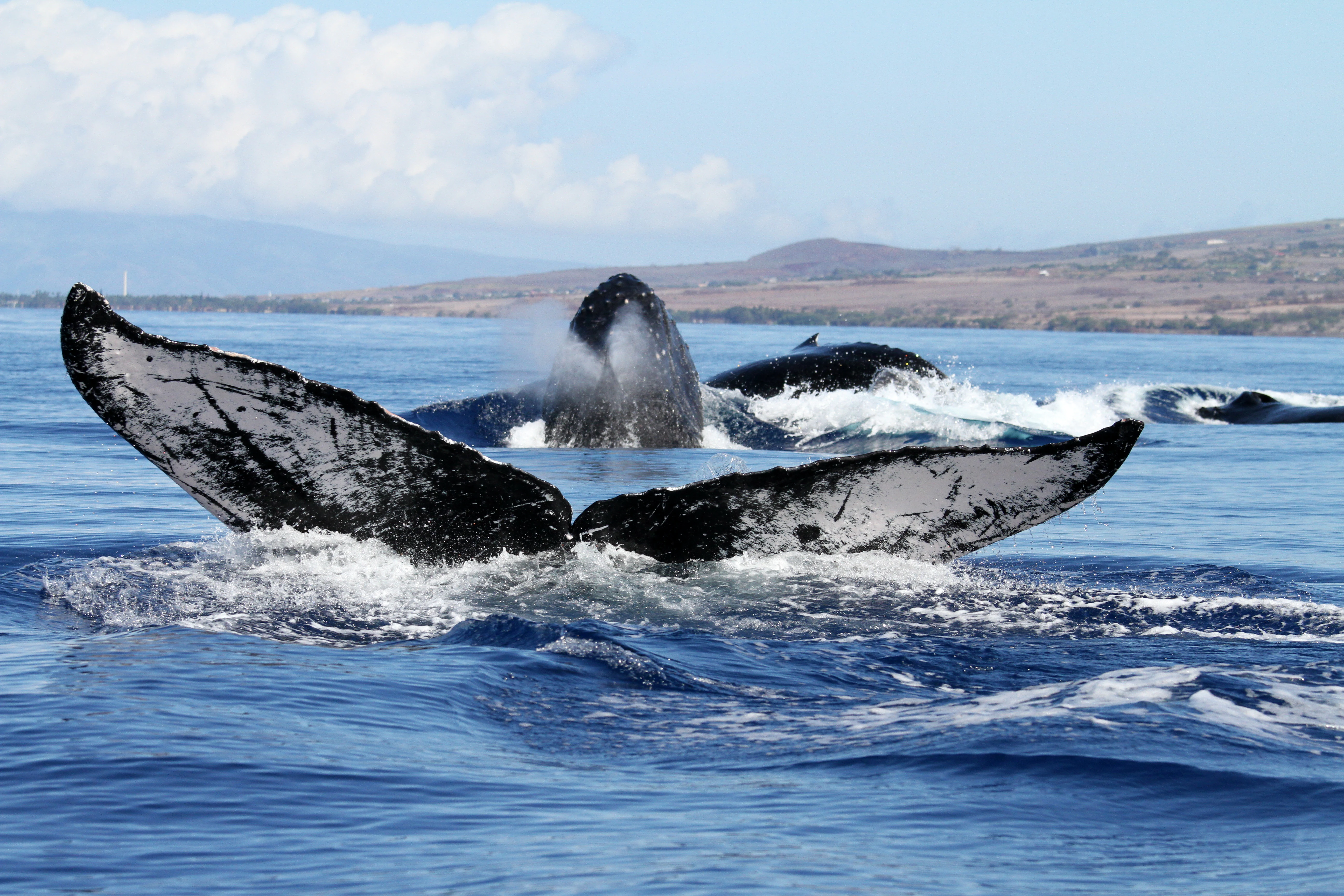
A humpback whale tail fluke rises out of the blue ocean water with other whale parts surfacing nearby; a coastal shoreline is visible in the background under a blue sky.
Humpback whales breaching in the waters of the Hawaiian Islands Humpback Whale National Marine Sanctuary.

Hawaiian Islands Humpback Whale National Marine Sanctuary history and protected-area timeline

Efforts to establish a marine sanctuary in Hawaii began in 1982, when NOAA advocated for the creation of a national marine sanctuary in the islands' waters. Public workshops brought scientists and community members together to discuss the proposal, though some residents opposed it, fearing further restrictions on fishing and ocean traffic. In 1984 Hawaii's then-Governor George Ariyoshi suspended further consideration of the sanctuary.

Renewed momentum came in October 1990, when the United States Congress again directed NOAA to evaluate the feasibility of designating a national marine sanctuary in Hawaii. After additional rounds of public meetings and hearings across the main islands, the designation was finalized on November 4, 1992. To build local support, the resulting legislation largely incorporated existing protections, focusing on approach and harassment of whales, waste discharge, and alteration of the seabed, rather than layering on new restrictions.

The sanctuary's boundaries were left flexible, allowing the United States Secretary of Commerce, in consultation with the Governor of Hawaii, to modify them in response to public input. A Sanctuary Advisory Council was also established, bringing together government agencies and community representatives. It was not until June 5, 1997, that Governor Benjamin Cayetano formally approved the sanctuary, completing the political and administrative path to its operation. Subsequent management plan reviews, including one approved by Governor Cayetano in September 2002, have continued to shape the sanctuary's programs and oversight.

Hawaiian Islands Humpback Whale National Marine Sanctuary landscape and geographic character

The sanctuary defines a vast underwater landscape around the Hawaiian Islands, shaped by volcanic islands and reef ecosystems. Its waters begin at the shoreline and extend seaward to depths of roughly 600 feet in many locations, encompassing an unusual gradient from shallow coastal zones to deeper offshore environments.

Close to shore, fringing coral reefs follow the edges of the islands, while further offshore more extensive reef structures develop in deeper water. Between these reef zones lie other important habitats, including seagrass beds that fringe the islands and provide shelter for a wide range of marine life. Hawaii's reef systems are particularly notable because of the islands' extreme geographic isolation, which has allowed marine species to evolve independently. This isolation is reflected in the high level of endemism, with more than a quarter of Hawaii's reef animals found nowhere else in the world, giving the sanctuary a distinctive reefscape among the world's marine protected areas.
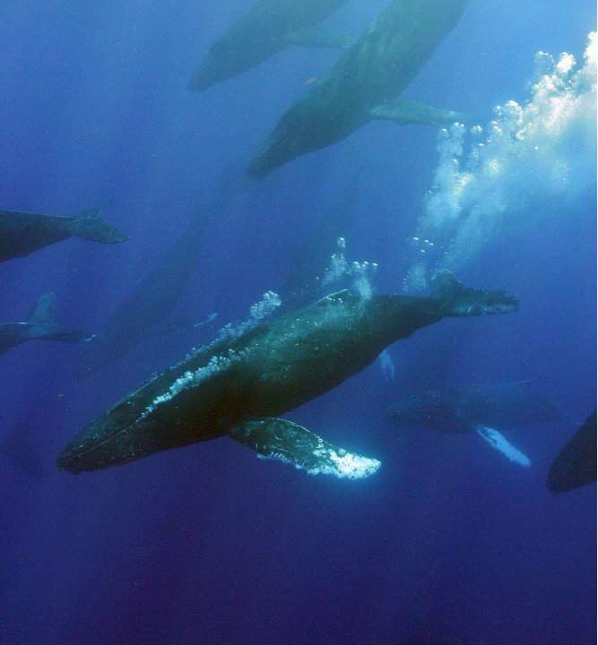
Underwater view of several humpback whales swimming in deep blue water with air bubbles rising toward the surface.
A group of humpback whales swimming in the deep blue waters of the Hawaiian Islands Humpback Whale National Marine Sanctuary.

Hawaiian Islands Humpback Whale National Marine Sanctuary ecosystems, habitats, and plant life

The Hawaiian Islands Humpback Whale National Marine Sanctuary protects a layered marine ecosystem that ranges from shallow reef flats to deeper offshore waters. Fringing reefs line the islands, while more extensive reef systems develop further out to sea. Seagrass beds occupy other important nearshore zones, creating habitat mosaics that support a wide variety of fish, invertebrates, and other marine organisms.

Because of Hawaii's isolation in the central Pacific, the sanctuary's reef ecosystems have developed in relative isolation from other reef systems around the world. Roughly a quarter or more of Hawaii's reef animals are endemic, occurring nowhere else on Earth. This makes the sanctuary not only a whale habitat but also a globally significant refuge for unique coral reef biodiversity. The combination of warm, shallow breeding grounds for humpback whales and the ecological distinctiveness of Hawaii's reefs gives the protected area a dual conservation identity.

A view of the entrance to the Hawaiian Islands Humpback Whale National Marine Sanctuary visitor center, featuring a blue sign with a whale tail silhouette and a gated facility.
The entrance to the Hawaiian Islands Humpback Whale National Marine Sanctuary visitor center in Kihei, Maui.

Hawaiian Islands Humpback Whale National Marine Sanctuary wildlife and species highlights

The signature wildlife of the sanctuary is the North Pacific humpback whale. Each winter, an estimated 4,000 to 10,000 of these whales, representing an estimated two-thirds of the North Pacific population, migrate to Hawaiian waters to bear and nurse calves and to mate. While in Hawaii they feed very little because of their narrow throat size, instead relying on fat reserves built up during summer feeding in colder Alaskan waters. Humpbacks are known for their exceptionally long flippers, which can reach up to about a third of their body length, and for the unique white patterns on their tail flukes, which scientists use to identify individual whales like fingerprints.

The whales engage in a range of visible behaviors, including breaching, where they throw their bodies clear of the water; competitive pods during the breeding season, when groups of males may slam into one another with pectoral fins and flukes; and bubble trailing and other surface displays. Male humpbacks also produce the long, complex vocal sequences often described as songs, which can last 10 to 20 minutes, are shared among individuals in the same region, and evolve gradually from year to year.

Beyond whales, the sanctuary's reefs host high levels of endemic marine life. Residents and visitors also commonly encounter dolphins traveling alongside mothers and calves in the sanctuary waters, and the broader reef ecosystem supports diverse fish, invertebrate, and coral communities that define Hawaii's marine environment.

Hawaiian Islands Humpback Whale National Marine Sanctuary conservation status and protection priorities

The sanctuary was created to protect the endangered North Pacific humpback whale and its habitat, making marine mammal conservation its core mandate. Its establishment reflects both international protections, such as the International Whaling Commission's 1966 ban on commercial whaling, and domestic concern about the depleted state of humpback populations that had once numbered in the tens of thousands before large-scale whaling.

Conservation within the sanctuary is pursued through a combination of research, long-term monitoring, public education, and coordination with other agencies. Unlike many other United States National Marine Sanctuaries, it does not enforce its own set of no-take, no-wake, or no-go zones, instead working through partner agencies and emphasizing coexistence with a wide variety of human activities.

The reef ecosystems within the sanctuary, with more than a quarter of reef species found nowhere else on Earth, are also a key conservation focus. Protecting these endemic communities, together with the breeding and calving habitat of the North Pacific humpback population, gives the sanctuary substantial significance for both marine mammal and coral reef conservation in the central Pacific.

Hawaiian Islands Humpback Whale National Marine Sanctuary cultural meaning and human context

Native Hawaiians have long held close cultural and spiritual relationships with the marine environment that the sanctuary now protects, and these traditional connections to whales, reefs, and ocean resources are recognized in the sanctuary's outreach and interpretive activities.

This cultural heritage is reflected in educational programming, hula, and community events associated with the sanctuary's visitor and education centers. The protection of whales and reefs is framed not only as an ecological concern but also as a continuation of longstanding Hawaiian ties to the sea, while allowing modern uses such as fishing, whale watching, recreation, and shipping to continue alongside these cultural values.

Top sights and standout views in Hawaiian Islands Humpback Whale National Marine Sanctuary

The sanctuary protects roughly 1,400 square miles of Hawaii's coastal and offshore waters around the islands. It is the winter home of an estimated two-thirds of the North Pacific humpback whale population, making it one of the world's most important whale breeding and calving grounds. The reef ecosystems within its boundaries harbor exceptionally high rates of marine endemism, with more than a quarter of reef animals unique to Hawaii.

The sanctuary also pairs unusual flexibility in management with a strong focus on outreach. It relies on partner agencies for enforcement, supports public education through facilities including the Sanctuary Education Center on Maui and the Kaua'i Ocean Discovery visitor center on Kaua'i, and engages volunteers in programs such as the annual Ocean Count. At the same time, it supports a substantial Hawaiian whale watching economy estimated to contribute several hundred jobs and tens of millions of dollars in revenue.

Best time to visit Hawaiian Islands Humpback Whale National Marine Sanctuary

The most distinctive time to experience the sanctuary is during Hawaii's winter months, when North Pacific humpback whales gather in large numbers in Hawaiian waters to breed, give birth, and nurse their calves. Peak whale presence makes this the season when whale watching, shoreline observation, and interpretive experiences around the sanctuary are most rewarding.

Outside the winter whale season, the sanctuary's reefs, seagrass beds, and other marine habitats remain active year-round, offering different conditions for snorkeling, diving, reef viewing, and general ocean recreation. The visitor centers associated with the sanctuary operate year-round, making winter the highlight for whale-focused visits while other seasons offer quieter reef and coastal experiences.

Monthly climate preview

Long-term representative measurements of annual temperature and precipitation rhythms

Hawaiian Islands Humpback Whale National Marine Sanctuary Climate Normals and Weather by Month

Representative coordinate records show sustained monthly temperature and precipitation normals across the designated coordinate point. Examining the complete twelve-month climatology dataset reveals detailed variations in seasonal averages for the protected marine region.
Annual mean25 °C
23 °C26 °C
Jan23°
Feb23°
Mar23°
Apr24°
May25°
Jun25°
Jul26°
Aug26°
Sep26°
Oct26°
Nov25°
Dec24°
Warmest month
September

26.4 °C

Coolest month
February

22.9 °C

Wettest month
March

2.6 mm/day

Driest month
June

1 mm/day

Park location guide

Geography guide, regional context, and park location map for Hawaiian Islands Humpback Whale National Marine Sanctuary

Hawaiian Islands Humpback Whale National Marine Sanctuary park geography, regions, and map view in United States of America

Understand where Hawaiian Islands Humpback Whale National Marine Sanctuary sits in United States of America through a broader geographic reading of the surrounding landscape, nearby location context, and its mapped position within the national park landscape.

How Hawaiian Islands Humpback Whale National Marine Sanctuary fits into United States of America

The United States of America is a federal presidential republic and one of the world's largest countries by area and population. It consists of 50 states across a vast territory spanning multiple time zones, with its capital in Washington, D.C. and largest city in New York City. The nation has a diverse economy, influential political system, and significant cultural and military presence globally.

Wider geography shaping Hawaiian Islands Humpback Whale National Marine Sanctuary in United States of America

The United States occupies a vast territory in North America, bordered by Canada to the north and Mexico to the south. The 48 contiguous states stretch from the Atlantic to the Pacific Ocean, while Alaska occupies the northwestern region and Hawaii is an archipelago in the Pacific. The country encompasses diverse terrain including the Rocky Mountains, Appalachian Mountains, Great Plains, and extensive river systems.

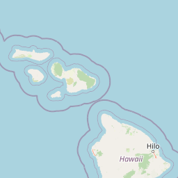
Map view of Hawaiian Islands Humpback Whale National Marine Sanctuary

Use this park location map to pinpoint Hawaiian Islands Humpback Whale National Marine Sanctuary in United States of America, understand its exact geographic position, and read its mapped placement within the surrounding landscape more clearly.

Pigeon | © OpenStreetMap contributors

Location context for Hawaiian Islands Humpback Whale National Marine Sanctuary

Hawaii
Recorded earthquake history

Explore Historical Earthquake Records Associated with the Sanctuary

Review documented seismic history for the Hawaiian Islands Humpback Whale National Marine Sanctuary through a structured catalogue of events. This resource enables MoriAtlas users to investigate regional earthquake trends using precise epicentre distance data and historical USGS earthquake catalogues.

Hawaiian Islands Humpback Whale National Marine Sanctuary Earthquake Records

Catalogued events

1,005 events

Strongest magnitude

Magnitude 6.7

Most recent event

Sep 8, 2026

This history includes earthquakes recorded inside the park or within 50 km of its borders

Visualizing underwater marine landscapes, coral reef ecosystems, and coastal habitats.

Hawaiian Islands Humpback Whale National Marine Sanctuary Photos and Scenery

Examinations of Hawaiian Islands Humpback Whale National Marine Sanctuary photos reveal complex volcanic topography and thriving offshore marine habitats. Visualizing coastal waters and reef systems helps observers understand the distinct conservation landscape supporting humpback whales.

A humpback whale tail fluke rises out of the blue ocean water with other whale parts surfacing nearby; a coastal shoreline is visible in the background under a blue sky.

A humpback whale breaching out of the ocean water near a small black motorboat occupied by three people wearing life jackets.

Underwater view of several humpback whales swimming in deep blue water with air bubbles rising toward the surface.

A view of the entrance to the Hawaiian Islands Humpback Whale National Marine Sanctuary visitor center, featuring a blue sign with a whale tail silhouette and a gated facility.

Park atlas

Compare surrounding marine environments, coastal habitats, and regional island conservation landscapes

Parks Near Hawaiian Islands Humpback Whale National Marine Sanctuary and Related Protected Areas

Browse nearby marine reserves and protected coastal landscapes linked to Hawaiian Islands Humpback Whale National Marine Sanctuary. Compare regional island geography and expanding ocean conservation networks across the surrounding archipelago.
National parkMaui County
20 km away#1 closest

East

Haleakalā National Park: Exploring its Protected Landscape and Maui County Geography

Understand the park's mapped boundaries and regional terrain context.

Haleakalā National Park represents a vital protected landscape, offering unique insights into the geography of Maui County. This entry provides a foundation for understanding the park's specific identity as a national park and its role within the broader regional context. Explore its protected-area characteristics and the mapped natural terrain that defines its landscape, making it a key destination for geographic exploration.

Area
134.62 km²
Established
1961
IUCN
II
Visitors
1.1M annual
National parkUnited States of America
48 km away#2 closest

Southeast

Hawaiʻi Volcanoes National Park: National Park Geographic Atlas and Protected Landscape

Mapped volcanic terrain and regional protected area context.

Delve into the geographic identity of Hawaiʻi Volcanoes National Park, a notable protected area within the United States of America. This park offers unique volcanic landscapes and provides an invaluable resource for understanding mapped terrain, regional geography, and the specific boundaries of conservation lands. Explore its distinct environmental features and discover its significance through a detailed atlas-oriented lens.

Area
1,434.45 km²
Established
1916
IUCN
II
Visitors
1.4M annual
Marine protected areaHawaii
About 1,166 km away#3 closest

West

Papahānaumokuākea Marine National Monument: Mapped Geography and Protected Pacific Seas

A sprawling marine reserve spanning Northwestern Hawaiian islands and atolls.

Papahānaumokuākea Marine National Monument covers a vast expanse of the Pacific, including coral reefs, submerged banks, and ten islands and atolls. This protected area offers significant insights into remote oceanic geography, featuring critical habitats for endemic species and layered maritime historical sites. Explore the structural map and landscape composition of this immense marine protected zone.

Area
1,508,870 km²
Established
2006
Relief
Lowland
Climate
Tropical
Protected areaMarshall Islands
About 3,397 km away#4 closest

West

Bikar Atoll Protected Area: Geographic Overview of a Remote Marshall Islands Coral Atoll

A pristine, uninhabited coral sanctuary and critical Pacific marine habitat.

Bikar Atoll is a remote, diamond-shaped coral ring located in the Ratak Chain of the Marshall Islands. Defined by its shallow lagoon, continuous reef structure, and arid islets, the atoll serves as a vital nesting site for seabirds and green turtles. This protected area remains one of the most ecologically undisturbed sites in the Pacific, offering rare insight into natural atoll morphology and island conservation.

Area
0.5 km²
Established
2025
Relief
Lowland
Climate
Tropical
Protected areaMarshall Islands
About 3,419 km away#5 closest

West

Bokak Atoll Protected Area: Mapping the Northern Ratak Chain of the Marshall Islands

A remote coral atoll with a rare perched lagoon and pristine reef ecosystem

Bokak Atoll represents a primary example of an undisturbed central Pacific coral atoll, defined by its lack of introduced species and its striking perched lagoon. The landscape consists of low coral islets along a crescent reef, creating a specialized habitat for seabird colonies and stony coral reefs. This geographic overview examines the atoll's isolation and its status as a critical protected natural area within the wider Marshall Islands territory.

Area
129 km²
Relief
Lowland
Climate
Tropical
Access
Remote access
Protected areaMarshall Islands
About 3,505 km away#6 closest

West

Ailuk Atoll Protected Area: Geography and Mapped Coral Landscapes in the Marshall Islands

Pacific atoll terrain, lagoon systems, and island geography

Study the geographic composition of Ailuk Atoll, featuring its classic ring of coral islets, deep-water reef passes, and vast central lagoon. This protected area offers insight into the subsidence-driven formation of Marshallese island chains and the enduring human reliance on traditional maritime navigation within a fragile Pacific ecosystem.

Area
5.4 km²
Relief
Lowland
Climate
Tropical
Access
Remote access
Protected areaMarshall Islands
About 3,507 km away#7 closest

West

Arno Atoll: A Rare Triple Lagoon Coral Protected Area in the Marshall Islands

Mapped geography and hydrological landscape context

Arno Atoll stands out as a unique geographic entity in the Ratak Chain with its triple lagoon configuration. Spanning 133 islands in the North Pacific, this protected area offers insight into atoll reef systems, low lying coral landscapes, and the environmental framework of the Marshall Islands.

Area
13 km²
Relief
Lowland
Climate
Tropical
Scope
Mixed
A watercolor painting showing a panoramic view of soft, green rolling hills, a cluster of trees, and a calm water surface in a light, muted palette.
Protected areaMarshall Islands
About 3,537 km away#8 closest

West

Majuro: Mapping the Protected Coral Atoll Landscapes and Island Geography of the Marshall Islands

Regional atoll atlas and protected lagoon geography.

Majuro serves as the primary administrative and geographic anchor within the Marshall Islands. This detailed mapping showcases the atoll's signature structure, characterized by 64 narrow islets enclosing a massive, sheltered 295 square kilometer lagoon. Delve into the specific landforms and regional marine geography that define this Pacific protected environment.

Area
9.7 km²
Relief
Lowland
Climate
Tropical
Access
Moderate access

Common questions about visiting, size, designation, and location context for Hawaiian Islands Humpback Whale National Marine Sanctuary

Hawaiian Islands Humpback Whale National Marine Sanctuary FAQs for park facts, access, geography, and protected area context

Find quick answers about Hawaiian Islands Humpback Whale National Marine Sanctuary, including protected-area facts, park geography, trail and visitor context, and how the park fits into its surrounding country and regional landscape.
MoriAtlas Explorer

Continue Your Protected Areas Search Across the Global Atlas

Deepen your exploration by continuing the structured search for national parks and protected areas worldwide. Utilize the comprehensive filtering capabilities to compare different conservation landscapes and refine your understanding of global park geography. Discover more about the distribution and characteristics of protected natural areas.

Global natural geography