
Mori Atlas logo
Nature reserveHelpensteiner Bachtal, oberes Schaagbachtal und Petersholz

A complex mosaic of sandy heathlands, brook valleys, and remnant forest habitats near the border

Helpensteiner Bachtal, oberes Schaagbachtal und Petersholz Protected Nature Reserve Geography

(Naturschutzgebiet Helpensteiner Bachtal, oberes Schaagbachtal und Petersholz)

Helpensteiner Bachtal, oberes Schaagbachtal und Petersholz preserves a distinctive cultural and ecological landscape in the Heinsberg district of North Rhine-Westphalia. The area features a complex intersection of marshy brook valleys, nutrient-poor sandy grasslands, and near-natural oak and beech woodlands. A disused railway embankment further shapes the terrain, providing a warm, dry corridor through an otherwise wetland-dominated environment that serves as an essential node for regional biodiversity.

nature reserveheathlandsandy grasslandswamp forestfloodplain woodlandoak-beech forest
A flat-style vector illustration of a mountain valley with evergreen trees in the foreground, rugged peaks in the background, and a calm lake reflecting the scene.

Helpensteiner Bachtal, oberes Schaagbachtal und Petersholz

Nature reserve

Park overview

Structured park overview, official facts, and landscape profile for Helpensteiner Bachtal, oberes Schaagbachtal und Petersholz

Helpensteiner Bachtal, oberes Schaagbachtal und Petersholz park facts, protected area profile, and essential visitor context

Review the core facts for Helpensteiner Bachtal, oberes Schaagbachtal und Petersholz, including designation, size, terrain, visitor scale, habitats, and operating context in one park-focused overview.

About Helpensteiner Bachtal, oberes Schaagbachtal und Petersholz

Helpensteiner Bachtal, oberes Schaagbachtal und Petersholz is a nature reserve of about 692.9 hectares located in the Heinsberg district of North Rhine-Westphalia, in the western part of Germany close to the Netherlands. Geographically it sits in the gently undulating countryside west of Wegberg's historic center, between the Wegberg district of Dalheim and the Erkelenz district of Vossem. The two namesake brook valleys, those of the Helpensteiner Bach and the Schaagbach, structure the area and create the hydrological backbone of the protected landscape.

The reserve is a striking example of habitat diversity in a relatively confined area. Sandy soils support dry heathland and sand-poor grassland communities that harbor heat-loving flora and fauna, while the brook valleys provide a contrasting environment of wet woodland, spring-fed reaches, ponds, and floodplain forest. Within this mosaic, a disused railway line running through the area acts as a long, dry, sunny corridor, supporting plant and animal communities typical of nutrient-poor, sun-exposed habitats and serving as a structural link in the wider ecological network of the district.

The protected-area designation HS-005 has been in force since 1985. Its conservation objectives explicitly cover the preservation and improvement of large heath and sand-poor grassland areas, the protection of a disused railway corridor as a connecting biotope for species such as the sand lizard and silicate-grassland flora, and the maintenance of structurally rich beech and oak forests alongside near-natural brook courses, ponds, and pools. The reserve also aims to preserve spring areas, swamp forests, and floodplain woods that support a regionally important avifauna and wetland invertebrate fauna, as well as amphibian breeding habitats.

Because it contains elements of nearly every major lowland habitat type found in the Lower Rhine region within a single protected zone, the area has a particular conservation role. It functions not just as a refuge for individual species but as a connected landscape in which dry, wet, open, and forested habitats reinforce each other, allowing the long-term persistence of species that would otherwise be vulnerable to forest monocultures and agricultural intensification in the surrounding region.

Quick facts and research context for Helpensteiner Bachtal, oberes Schaagbachtal und Petersholz

Helpensteiner Bachtal, oberes Schaagbachtal und Petersholz is a nature reserve (Naturschutzgebiet) of roughly 693 hectares in the Heinsberg district of North Rhine-Westphalia, Germany. It lies west of the town of Wegberg and extends up to the border with the Netherlands. Protection under the key HS-005 dates to 1985 and applies to a landscape shaped by the Helpensteiner Bach and the Schaagbach streams, their brook valleys, surrounding heath, and mixed forests. Conservation aims cover heath, sandy grassland, swamp woodland, oak and beech forest, near-natural streams, ponds, and a disused railway line acting as a connecting biotope.

Park context

Deeper park guide and search-rich context for Helpensteiner Bachtal, oberes Schaagbachtal und Petersholz

Helpensteiner Bachtal, oberes Schaagbachtal und Petersholz history, landscape, wildlife, and travel context

Explore Helpensteiner Bachtal, oberes Schaagbachtal und Petersholz through its history, landscape character, ecosystems, wildlife, conservation priorities, cultural context, and seasonal travel timing in a structured park guide built for atlas discovery and search intent.

Why Helpensteiner Bachtal, oberes Schaagbachtal und Petersholz stands out

The reserve is best known for combining large sand-heath and sandy grassland habitats with ecologically rich lowland stream valleys. Within a single protected area, it conserves open heathland patches, dry nutrient-poor grasslands, near-natural brook courses, swamp and floodplain forests, and structured deciduous woodland set within a sea of conifer plantations. The mosaic supports heat-loving species on the disused railway embankment alongside wetland-dependent species like kingfisher and royal fern along the Helpensteiner Bach and Schaagbach. It is also notable as a stepping stone in the network of nature reserves of the Heinsberg district, reaching up to the Dutch border. The contrast between the intensively used open landscape, the historic railway corridor, and the more secluded forest valleys gives the reserve a strong ecological diversity for its relatively small total size.
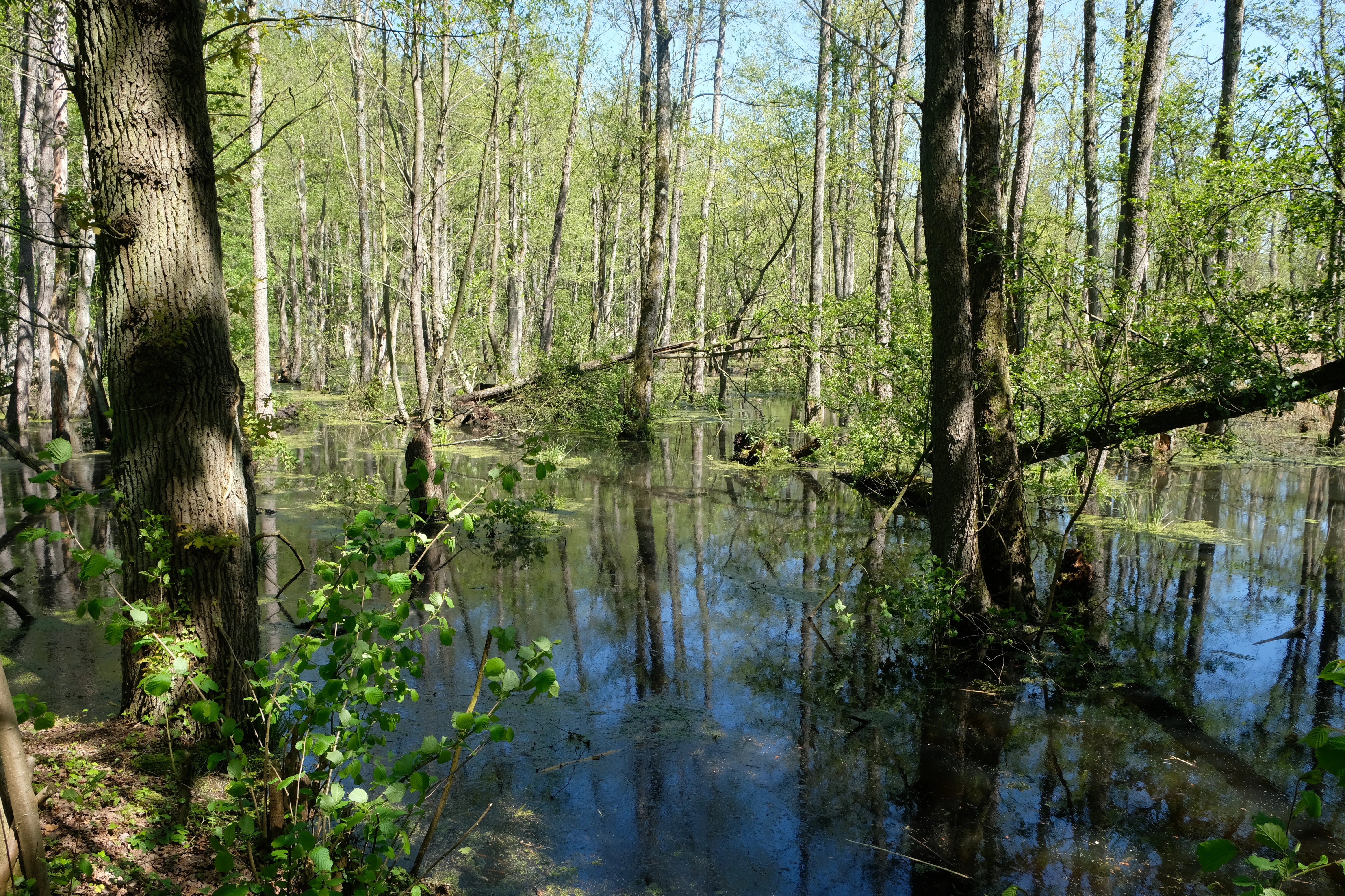
A swampy forest area with water flooding the forest floor, surrounded by mature trees with light green spring foliage.
A flooded swamp forest area in Helpensteiner Bachtal, shaped by the presence of a beaver dam.

Helpensteiner Bachtal, oberes Schaagbachtal und Petersholz history and protected-area timeline

The nature reserve Helpensteiner Bachtal, oberes Schaagbachtal und Petersholz was formally placed under protection in 1985 under the designation HS-005 of the Heinsberg district. The preservation order reflects the gradual recognition that the traditional cultural landscape around the Helpensteiner Bach and the Schaagbach, including its heath, sand grasslands, scattered deciduous woods, and disused railway embankment, was becoming ecologically rare and worthy of statutory safeguarding.

The reserve forms part of a long-running effort in the Heinsberg district to conserve remaining patches of heathland, sandy grassland, and near-natural brook valleys. Within this broader program, the area at Wegberg was specifically identified for the combination of dry open habitats along the old railway line and structured, ecologically valuable woodland and wetland along the brook valleys.

Although the named landscape has older agricultural, forestry, and transport origins, the most significant turning point for the site is the formal protection regime established in 1985. Since then, the reserve has functioned as one of the key nature conservation areas in the western part of the Heinsberg district and as a transboundary ecological link with the Dutch landscape just across the border.

Helpensteiner Bachtal, oberes Schaagbachtal und Petersholz landscape and geographic character

The landscape of the reserve is shaped primarily by two brook valleys and the open sandy uplands that surround them. The Helpensteiner Bach and the Schaagbach cut shallow valleys into a gently rolling plateau, with near-natural meanders, small oxbow-like pools, spring-fed reaches, and periodic floodplain flats. Between and beside these watercourses lie drier sandy ridges that historically were kept open as heath and as poor, species-rich grassland.

A defining linear feature of the area is a disused railway line running through the reserve. Its elevated, sun-exposed embankments and coarse mineral substrate create a dry, warm corridor through an otherwise largely wooded and wet landscape. This embankment now functions as a small-scale dry-grassland and heath habitat, embedded within the broader matrix of forest and stream valleys.

The northern and western edges of the reserve reach up to the Dutch border, giving the area a transboundary landscape character. The juxtaposition of valley, plateau, forest, heath, and infrastructural remnant creates a varied and visually distinctive countryside typical of the historic cultural landscape of the Lower Rhine border region.

Helpensteiner Bachtal, oberes Schaagbachtal und Petersholz ecosystems, habitats, and plant life

Ecologically, the reserve is best understood as a mosaic landscape in which dry and wet habitats are unusually close together. Dry sandy ridges host heathland and sand-poor grassland communities that depend on low nutrient levels and regular disturbance or grazing. These open habitats are interspersed with structurally rich patches of deciduous forest, especially beech and oak woodland, and with contiguous conifer plantations that the conservation strategy seeks to enrich with native broadleaf patches.

In the brook valleys, the ecological character shifts sharply. Near-natural sections of the Helpensteiner Bach and Schaagbach, along with their small tributaries and spring outlets, support swamp forest, alder floodplain woodland, and small open water bodies such as ponds and pools. The combination of oxygen-rich, shaded stream sections and stagnant or slow-moving water creates habitats for a wide range of wetland and riparian plants and invertebrates. The reserve's goals explicitly include the maintenance of these wet woodland and aquatic habitats, as well as the re-development of a wet heath area where the open and wet ecological zones overlap.

This combination of heath, dry grassland, deciduous woodland, swamp forest, and near-natural running water within a single protected perimeter makes the area ecologically significant. It allows for ecological processes typical of multiple lowland habitat types to persist in close proximity, providing both refuge and connectivity for species that depend on these transitional landscapes.

Helpensteiner Bachtal, oberes Schaagbachtal und Petersholz wildlife and species highlights

The reserve's wildlife value arises from the fact that it brings together dry, warm habitats and cold, wet habitats on a small scale. The disused railway embankment and the surrounding sandy heathland create habitat for heat-loving reptiles and invertebrates, and among the named objectives is the conservation of the sand lizard as a characteristic species of these dry linear habitats, along with invertebrate and plant communities of silicate-poor grassland.

The brook valleys and their associated ponds are framed as important habitat for amphibians, with the standing water bodies serving as breeding sites for several species. The near-natural streams and floodplain woodlands support a diverse bird community; the kingfisher is specifically mentioned in the reserve's protection goals as a species dependent on clear, fish-rich small watercourses. The reserve's combination of wet woodland, spring areas, and streams also supports a rich hygrophilic invertebrate fauna, meaning invertebrates that depend on consistently moist conditions.

Treating these habitats together rather than separately is part of the reserve's ecological logic: dry heath and railway habitats support one set of species, while swamp forests, ponds, and clean streams support another, with the woodland matrix providing habitat for additional forest-dependent species. The reserve therefore plays an unusually broad wildlife role for an area of its size in the Lower Rhine region.

Helpensteiner Bachtal, oberes Schaagbachtal und Petersholz conservation status and protection priorities

The reserve has been protected since 1985 under the official designation HS-005 in the Heinsberg district. Its conservation value lies not in any single rare species but in the persistence of a complete suite of lowland habitat types that are otherwise increasingly rare in the intensively used landscape of western North Rhine-Westphalia. Large areas of heath and sand-poor grassland, structurally rich beech and oak forest, swamp and floodplain woodland, near-natural lowland streams, and relict wet heath are all part of the formal protection aims.

A central conservation strategy is to maintain ecological connectivity within the area. The disused railway line is intentionally managed as a connecting biotope that links dry habitat patches and provides a continuous sun-exposed corridor through the forest-dominated landscape. Equally, the conservation order emphasizes the protection of springs and near-natural brook sections so that the hydrological basis of the wet woodland and amphibian habitats is preserved.

The reserve is also part of a wider conservation framework in the Heinsberg district, grouping together with other Naturschutzgebiete such as Meinweg, Schaagbachtal, Teverener Heide, Schwalmbruch, and others. Within this district-level network it plays a particular role as a heath, stream valley, and forest mosaic close to the Dutch border, supporting transboundary ecological processes and acting as a local reference site for lowland habitat conservation in the western Lower Rhine region.

Helpensteiner Bachtal, oberes Schaagbachtal und Petersholz cultural meaning and human context

The cultural context of the reserve is shaped by centuries of low-intensity land use in the sandy-soil landscape west of Wegberg. Heath, sand-poor grassland, and oak-beech woodland historically coexisted here with small-scale agriculture and forestry. The course of the disused railway line points to the area's transport history, when such corridors were built through the rural landscape; their conversion into ecological corridors after abandonment is now itself part of the local conservation story.

The reserve lies in a region marked by traditional rural settlement between Wegberg, Dalheim, and the Erkelenz district of Vossem, and its proximity to the Dutch border gives it an additional layer of cross-border regional identity. As part of the Heinsberg district's network of nature reserves, it reflects the district's long-running effort to recognize and protect remnants of the historic cultural landscape alongside their ecological value.

Top sights and standout views in Helpensteiner Bachtal, oberes Schaagbachtal und Petersholz

Among the reserve's most distinctive features are the mosaic of dry heath and sand-poor grassland alongside wet, near-natural brook valleys; the disused railway embankment acting as a sunny ecological corridor; the swamp forests and floodplain woods along the Helpensteiner Bach and Schaagbach; and the protected area's role as one of the connected nature reserves of the Heinsberg district at the Dutch border. The combination of dry, wet, open, and forested habitats in a single protected area of around 693 hectares gives it a notably rich ecological profile for this region.

Best time to visit Helpensteiner Bachtal, oberes Schaagbachtal und Petersholz

The character of the reserve shifts meaningfully between seasons. Spring and early summer are typically the most expressive period for the wet valleys, when stream-side vegetation, pond margins, and amphibian activity are at their peak, and the deciduous woodlands are in fresh leaf. Late summer and early autumn are usually the best period to experience the heathland and sand-poor grassland, when flowering and insect activity in the open habitats are most visible, and when the structural contrast between dry ridges and shaded valleys is sharpest.

For general landscape experience, any frost-free, dry period with good visibility will showcase the contrast between the open sandy uplands and the wooded brook valleys. Visitors interested in birdlife generally find the cooler months more rewarding, when waterfowl and wetland birds concentrate along the unfrozen sections of the streams and ponds, while warmer months are better for reptiles and typical heath and grassland invertebrates along the disused railway corridor.

Monthly climate preview

Long-term monthly temperature and precipitation patterns across the protected landscape

Helpensteiner Bachtal, oberes Schaagbachtal und Petersholz Climate Normals and Temperature Rhythms

Measured historical data for Helpensteiner Bachtal, oberes Schaagbachtal und Petersholz reveals steady variations in average temperature and daily precipitation from winter lows to summer highs. Analyzing the full monthly climate profile provides deeper insight into long-term environmental patterns across the protected terrain.
Annual mean10 °C
2 °C19 °C
Jan
Feb
Mar
Apr10°
May14°
Jun17°
Jul19°
Aug19°
Sep15°
Oct10°
Nov
Dec
Warmest month
July

19 °C

Coolest month
January

1.8 °C

Wettest month
December

2.4 mm/day

Driest month
April

1.5 mm/day

Park location guide

Geography guide, regional context, and park location map for Helpensteiner Bachtal, oberes Schaagbachtal und Petersholz

Helpensteiner Bachtal, oberes Schaagbachtal und Petersholz park geography, regions, and map view in Germany

Understand where Helpensteiner Bachtal, oberes Schaagbachtal und Petersholz sits in Germany through a broader geographic reading of the surrounding landscape, nearby location context, and its mapped position within the national park landscape.

How Helpensteiner Bachtal, oberes Schaagbachtal und Petersholz fits into Germany

Germany is a federal republic in Western and Central Europe with a population of over 83 million across sixteen constituent states. It is Europe's largest economy by nominal GDP and a major global exporter and importer. The capital is Berlin, and the country borders Denmark, Poland, Czech Republic, Austria, Switzerland, France, Luxembourg, Belgium, and the Netherlands.

Wider geography shaping Helpensteiner Bachtal, oberes Schaagbachtal und Petersholz in Germany

Germany is located in Western and Central Europe, spanning 357,022 km². It borders Denmark to the north, Poland and the Czech Republic to the east, Austria and Switzerland to the south, and France, Luxembourg, Belgium, and the Netherlands to the west. The country has coastlines on the Baltic Sea and North Sea to the north, with the Alps located in the southern region.

Map view of Helpensteiner Bachtal, oberes Schaagbachtal und Petersholz

Use this park location map to pinpoint Helpensteiner Bachtal, oberes Schaagbachtal und Petersholz in Germany, understand its exact geographic position, and read its mapped placement within the surrounding landscape more clearly.

Pigeon | © OpenStreetMap contributors

Location context for Helpensteiner Bachtal, oberes Schaagbachtal und Petersholz

North Rhine-Westphalia

Visualizing lowland stream valleys, sandy grasslands, and swamp forests across the protected reserve

Helpensteiner Bachtal, oberes Schaagbachtal und Petersholz Photos and Protected Landscape Scenery

Photographic documentation reveals the diverse terrain, brook courses, and distinct habitats of Helpensteiner Bachtal, oberes Schaagbachtal und Petersholz. Visual exploration provides a clear understanding of the protected landscape character and environmental mosaic found in this region.

A swampy forest area with water flooding the forest floor, surrounded by mature trees with light green spring foliage.

Park atlas

Discover related regional parks and connected lowland stream landscapes

Explore Protected Areas Near Helpensteiner Bachtal, Oberes Schaagbachtal und Petersholz

Compare Helpensteiner Bachtal, oberes Schaagbachtal und Petersholz with adjacent protected areas across the Heinsberg district. Broaden your geographic understanding of Lower Rhine valley habitats and cross border conservation zones.
Watercolor painting of a landscape featuring a stream, trees, and rolling hills
National parkLimburg
About 3 km away#1 closest

Northwest

De Meinweg National Park: Unique Terraced Landscape and Protected Area in Limburg

National Park with exceptional reptile and amphibian biodiversity.

De Meinweg National Park is a remarkable protected landscape located in the Dutch province of Limburg, distinguished by its rare terraced topography unlike any other in the Netherlands. This national park, covering 1,800 hectares, is a key component of the transboundary Grenspark Maas-Swalm-Nette, bordering Germany. Its ecological significance is underscored by its status as a Natura 2000 site, with notable biodiversity, particularly among reptiles and amphibians, and regenerating raised bogs. MoriAtlas offers a map-centric view of this unique protected area, detailing its geographic context and landscape features for structured discovery.

Area
18 km²
Established
1995
IUCN
II
Relief
Upland
Watercolor painting of a soft, hazy forest landscape with a pond in the foreground.
Nature reserveNorth Rhine-Westphalia
About 18 km away#2 closest

North

Kaldenkirchener Grenzwald Nature Reserve in North Rhine-Westphalia

Regional border forest with heath moors and rare arboretum stands

Explore the geographic character of the Kaldenkirchener Grenzwald, a significant nature reserve located in the Nettetal region. This area showcases the interplay between native sandy pine forests and protected heath moor remnants, while incorporating the unique Sequoiafarm arboretum. Gain insights into the border landscape of the Lower Rhine and the historical ecological restoration that defines this protected area within Germany.

Established
1949
Relief
Lowland
Climate
Temperate
Access
Easy access
Watercolor illustration of a peaceful lakeside landscape with soft green trees, rolling hills, and a calm body of water.
Protected landscapeGermany
About 20 km away#3 closest

North

Naturpark Maas-Schwalm-Nette: Geography, Protected Landscapes, and Regional Map Context

A cross-border protected area spanning Germany and the Netherlands

Naturpark Maas-Schwalm-Nette encompasses a wide cross-border expanse defined by the interaction of three distinct river systems. This protected landscape contains notable natural formations including the Krickenbecker Seen peat lakes and the juniper heath of the Lower Rhine. With terrain ranging from quiet border forests to extensive wetlands, the park serves as a primary geographic link between regional conservation zones in Germany and the Netherlands.

Area
870 km²
Established
2002
Relief
Lowland
Climate
Temperate
A soft watercolor painting of a winding river surrounded by grassy plains and distant hills, rendered in pale greens and neutral tones.
Protected areaNorth Rhine-Westphalia
About 23 km away#4 closest

North

Schwalm-Nette-Platte mit Grenzwald und Meinweg Protected Area Map and Landscape Analysis

Regional bird sanctuary and habitat mosaic in North Rhine-Westphalia

Schwalm-Nette-Platte mit Grenzwald und Meinweg encompasses roughly 77 square kilometers of varied lowland terrain, featuring pine and oak forests, dry heaths, and wetlands. This geographic overview highlights the unique arrangement of habitats that sustain significant migratory and breeding bird species across the Lower Rhine plain, providing a clear perspective on its role as a cross-border ecological site.

Area
77.22 km²
Established
1983
A horizontal watercolor painting depicting a gentle, hazy green landscape with rolling hills, a line of trees, and a foreground meadow.
Protected landscapeNorth Rhine-Westphalia
About 26 km away#5 closest

Southeast

Naturpark Rheinland: Geography and Protected Area Overview in North Rhine-Westphalia

A complex metropolitan nature park and lake district

Naturpark Rheinland represents a distinct convergence of reclaimed lignite mining landscapes, quiet lowland forests, and floodplain wetlands. Its mapped boundaries reveal a diverse terrain of ridges and river valleys that define the environmental character of the Cologne-Bonn metropolitan region.

Area
1,045 km²
Established
1959
Relief
Upland
Climate
Temperate
Watercolor painting of a peat bog ecosystem featuring green trees, pink and yellow vegetation, a body of water, and distant mountains
National parkNetherlands
About 34 km away#6 closest

Northwest

De Groote Peel National Park: Mapped Boundaries of a Unique Raised Bog & Wetland

Protected area with exceptional birdlife and peat landscape.

De Groote Peel National Park represents a crucial protected landscape in the Netherlands, renowned as one of the last substantial raised bogs in Western Europe. Its terrain is characterized by a distinct blend of open lakes formed by historical peat extraction, heathland expanses, and sensitive peat swamps. This Ramsar-designated wetland is a vital habitat for numerous bird species, offering unique opportunities for landscape context and atlas exploration of its ecological significance and mapped geographic features.

Area
13.4 km²
Established
1993
IUCN
II
Relief
Lowland
A watercolor painting showing a gentle, winding blue river flowing through a lush green landscape with soft hills in the distance.
Nature reserveNordrhein-Westfalen
About 34 km away#7 closest

Northeast

Der Meerbusch Nature Reserve: Mapped Protected Landscapes and Floodplain Forest Geography in Nordrhein-Westfalen

A historic alder swamp woodland and protected wetland habitat in the Lower Rhine region.

Der Meerbusch is a specialized nature reserve that preserves the ecological memory of the Lower Rhine through its intact alder swamp woodlands and old river channel formations. By examining the mapped boundaries and terrain, visitors can understand how this forest fragment functions as a critical wetland sanctuary within the industrialized landscape of Nordrhein-Westfalen.

Area
0.54 km²
Established
1987
IUCN
IV
Relief
Lowland
Nature reserveKrefeld
About 35 km away#8 closest

Northeast

Hülser Bruch Nature Reserve: Geographic Atlas and Protected Landscape Mapping for Krefeld

A historic glacial plain and protected wetland habitat in the Lower Rhine region.

Hülser Bruch represents a vital protected area in Krefeld, characterized by clay rich soils, high groundwater levels, and ancient brook channels. The reserve preserves a distinct mosaic of coppice woodland and earthen embankments that reveal the geomorphological influence of Pleistocene ice sheets on this lowland territory.

Area
4.3 km²
Established
2002
Relief
Lowland
Climate
Temperate

Common questions about visiting, size, designation, and location context for Helpensteiner Bachtal, oberes Schaagbachtal und Petersholz

Helpensteiner Bachtal, oberes Schaagbachtal und Petersholz FAQs for park facts, access, geography, and protected area context

Find quick answers about Helpensteiner Bachtal, oberes Schaagbachtal und Petersholz, including protected-area facts, park geography, trail and visitor context, and how the park fits into its surrounding country and regional landscape.
MoriAtlas Explorer

Continue Your Protected Areas Search Across the Global Atlas

Deepen your exploration by continuing the structured search for national parks and protected areas worldwide. Utilize the comprehensive filtering capabilities to compare different conservation landscapes and refine your understanding of global park geography. Discover more about the distribution and characteristics of protected natural areas.

Global natural geography