Mori Atlas logo
National parkHkakaborazi National Park

Discover the mapped boundaries and landscape identity of this protected area in Kachin State.

Hkakaborazi National Park: National Park Protected Area and Geographic Context

Hkakaborazi National Park represents a significant protected landscape within Kachin State, offering a distinct geographic identity for atlas exploration. This national park entry provides essential context on its mapped boundaries and the surrounding regional geography, enabling users to understand its place within the broader protected areas framework. Gain a clearer picture of this protected land's contribution to natural landscape discovery through detailed geographic and map-based data.

High altitude protected areaBiodiversity hotspotTropical rain forestConiferous forestEndemic species habitatMountain landscape

Hkakaborazi National Park

National park

Park overview

Structured park overview, official facts, and landscape profile for Hkakaborazi National Park

Hkakaborazi National Park park facts, protected area profile, and essential visitor context
Review the core facts for Hkakaborazi National Park, including designation, size, terrain, visitor scale, habitats, and operating context in one park-focused overview.

About Hkakaborazi National Park

Hkakaborazi National Park occupies a pivotal position in northern Myanmar's mountainous frontier, where the eastern Himalayas give way to the Indo-Burman mountain ranges. The park's creation in 1998 reflected growing recognition that this remote and ecologically intact landscape required formal protection to safeguard its extraordinary biodiversity and watersheds. The protected area encompasses the entire upper catchment of streams that eventually flow into the Ayeyarwady and Chindwin river basins, underscoring its hydrological significance for millions of people downstream. Despite its ecological importance, Hkakaborazi remains one of Myanmar's least accessible protected areas, with the mountainous terrain and limited infrastructure restricting regular visitation and enabling the persistence of relatively intact ecosystems. The park's management framework focuses on maintaining ecological processes while acknowledging the traditional land use patterns of local communities in the surrounding areas.

Quick facts and research context for Hkakaborazi National Park

Hkakaborazi National Park is located in Nogmung Township, Kachin State, approximately 50 miles north of the town of Putao. The park covers 3,810 square kilometers of mountainous terrain and was formally designated in 1998 under the management of Myanmar's Ministry of Natural Resources and Environmental Conservation, specifically through the Nature and Wildlife Conservation Division. The protected area forms a contiguous landscape with Bumhpa Bum Wildlife Sanctuary to the west and Hukaung Valley Wildlife Sanctuary to the east, together comprising the largest continuous expanse of natural forest in Myanmar. The elevation range of nearly 16,000 feet supports three major forest types: tropical rain forest, laurel forest, and coniferous forest, each hosting distinct biological communities.

Park context

Deeper park guide and search-rich context for Hkakaborazi National Park

Hkakaborazi National Park history, landscape, wildlife, and travel context
Explore Hkakaborazi National Park through its history, landscape character, ecosystems, wildlife, conservation priorities, cultural context, and seasonal travel timing in a structured park guide built for atlas discovery and search intent.

Why Hkakaborazi National Park stands out

Hkakaborazi is best known for protecting Hkakabo Razi, the summit of which rises to 5,710 meters and represents the highest point in Myanmar. The park is also celebrated for the discovery of the leaf muntjac, a previously undescribed species of barking deer first identified during wildlife surveys in the late 1990s, which brought international scientific attention to the region's biodiversity. The park's significance extends to its role within the Northern Forest Complex, one of the most extensive remaining tracts of intact forest in Southeast Asia, providing critical habitat for numerous threatened species including clouded leopards, western hoolock gibbons, and several hornbill species. The elevational range supports exceptional plant diversity, including at least 17 documented orchid species and diverse rhododendron communities that bloom in the subalpine zones.

Hkakaborazi National Park history and protected-area timeline

Hkakaborazi National Park was formally established in 1998 as part of Myanmar's expanding network of protected areas during the late 1990s. The designation came following scientific expeditions in 1996 and 1997 that documented the region's exceptional biodiversity, including the discovery of new species and significant range extensions for numerous flora and fauna. The establishment of the park was strategically linked to the broader vision of creating a connected conservation landscape in northern Myanmar, formalized through the inclusion of Hkakaborazi within the Northern Forest Complex alongside Bumhpa Bum Wildlife Sanctuary, Hukaung Valley Wildlife Sanctuary, and Hponkanrazi Wildlife Sanctuary. Management responsibility rests with the Nature and Wildlife Conservation Division under the Ministry of Natural Resources and Environmental Conservation, though resource constraints have limited the implementation of intensive management programs.

Hkakaborazi National Park landscape and geographic character

The landscape of Hkakaborazi is characterized by steep, V-shaped valleys carved by numerous streams and rivers descending from the central peak of Hkakabo Razi. The terrain rises dramatically from approximately 900 meters in the lower foothills to 5,710 meters at the summit, creating dramatic changes in topography, vegetation, and climate within relatively short horizontal distances. The mountain's prominence in the regional landscape means that the park is visible from considerable distances and forms a defining geographic feature of the far north of Myanmar. The lower elevations feature dense tropical rain forest with emergent trees reaching significant heights, while the middle elevations transition through laurel forests dominated by broadleaf evergreen species into mixed coniferous forests at higher elevations. The subalpine and alpine zones above approximately 3,000 meters feature scrub vegetation, meadows, and rocky terrain characteristic of high-altitude environments.

Hkakaborazi National Park ecosystems, habitats, and plant life

The ecological diversity of Hkakaborazi reflects its extraordinary elevation range and position at the intersection of multiple biogeographic regions. The tropical rain forests at lower elevations represent some of the most species-rich plant communities in Myanmar, featuring diverse Dipterocarpus, Elaeocarpus, and Nephelium species alongside numerous epiphytic orchids and climbing vines. The laurel forest zone supports a distinct community characterized by thicker, more leathery leaves adapted to the cooler and more humid conditions at mid-elevations, with dense understory layers and abundant epiphytic growth. Coniferous forests dominated by species adapted to cooler temperatures replace the broadleaf communities at higher elevations, providing habitat for different animal species adapted to these more open forest types. The bamboo-dominated areas that occur in selective zones add another structural dimension to the vegetation patterns, while the alpine meadows and heath above the treeline support specialized herbaceous species including numerous rhododendrons and primulas.

Hkakaborazi National Park wildlife and species highlights

The mammalian fauna of Hkakaborazi reflects the park's position at the interface of South Asian and Southeast Asian biomes, with species from both regions occurring within the protected area. The discovery of the leaf muntjac represents one of the most significant mammalian discoveries in recent decades in Southeast Asia, demonstrating that fundamental biodiversity research continues to yield new species even in relatively well-studied regions. Large ungulates including blue sheep, red serow, and takin are reported from the higher elevations, while the forested slopes support populations of several primate species including capped langurs and western hoolock gibbons. Carnivore diversity is notably high, with camera trap surveys documenting clouded leopards, marbled cats, leopard cats, Asiatic golden cats, and sun bears among the species present. The bird community includes at least 160 documented species, with hornbills particularly prominent, including the great hornbill, wreathed hornbill, and rufous-necked hornbill, all of which require large tracts of intact forest for their survival.

Hkakaborazi National Park conservation status and protection priorities

Hkakaborazi National Park plays a critical role in regional conservation by protecting a substantial portion of the Northern Forest Complex, which represents the largest remaining contiguous block of natural forest in Myanmar and one of the most significant conservation landscapes in mainland Southeast Asia. The park's elevation gradient provides habitat for numerous species with different climatic requirements, effectively acting as an elevational refuge that allows species to shift their ranges in response to climate change. The protection of watersheds feeding both the Ayeyarwady and Chindwin rivers extends the conservation significance beyond biodiversity to include vital ecosystem services for human communities downstream. The discovery of new species within the park's boundaries highlights its importance as a repository of undiscovered biodiversity and underscores the need for continued survey work and protection. Management challenges include addressing legacy impacts from selective logging in some areas and maintaining ecological connectivity with adjacent protected areas.

Top sights and standout views in Hkakaborazi National Park

Hkakaborazi offers visitors the opportunity to experience one of Southeast Asia's most ecologically diverse mountain landscapes, with trekking routes that traverse multiple forest types and elevation zones. The chance to view Hkakabo Razi, Myanmar's highest peak, from within its protected watershed provides both scenic reward and a sense of reaching a significant geographic landmark. Wildlife enthusiasts may encounter clouded leopards, numerous hornbill species, and the recently described leaf muntjac, though the park's remoteness means that sightings require patience and extended field time. The diversity of rhododendron species, particularly in the spring blooming season, adds botanical interest to any visit, while the altitudinal range enables observation of dramatically different ecosystems within a single trip.
Park location guide

Geography guide, regional context, and park location map for Hkakaborazi National Park

Hkakaborazi National Park park geography, regions, and map view in Myanmar
Understand where Hkakaborazi National Park sits in Myanmar through a broader geographic reading of the surrounding landscape, nearby location context, and its mapped position within the national park landscape.

How Hkakaborazi National Park fits into Myanmar

Myanmar is a Southeast Asian country with a rich history dating back to the Pagan Kingdom era. It is the largest country by area in Mainland Southeast Asia and is characterized by diverse ethnic groups, with the Bamar as the majority. The country operates under a military-led government and uses the Burmese language as its official language.

Wider geography shaping Hkakaborazi National Park in Myanmar

Myanmar is located in northwest Southeast Asia, bordered by India and Bangladesh to the northwest, China to the northeast, Laos and Thailand to the east and southeast, and the Andaman Sea and Bay of Bengal to the south and southwest. The terrain includes mountains, plains, and river valleys centered around the Irrawaddy River.

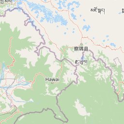
Map view of Hkakaborazi National Park

Use this park location map to pinpoint Hkakaborazi National Park in Myanmar, understand its exact geographic position, and read its mapped placement within the surrounding landscape more clearly.

Pigeon | © OpenStreetMap contributors

Location context for Hkakaborazi National Park

Kachin StateNogmung Township
Park atlas

Explore the Geographic Spread of Protected Landscapes and Mountainous Terrain in Northern Myanmar's Extensive Forest Complex

Discover More Protected Areas and National Parks Near Hkakaborazi National Park
Browse a curated list of national parks and other protected areas situated near Hkakaborazi National Park, extending across the rugged mountain geography and diverse forest ecosystems of northern Myanmar. Comparing these adjacent protected landscapes provides valuable geographic context for regional conservation efforts and the spread of unique high-altitude biodiversity across mainland Southeast Asia.
National parkArunachal Pradesh

Namdapha National Park: A National Park Detailed Entry for Geographic and Atlas Exploration

Explore mapped boundaries and regional landscape context in Arunachal Pradesh.

Namdapha National Park serves as a key protected area, offering a unique opportunity for structured geographic discovery. This entry focuses on its designation as a national park, providing detailed information about its mapped landscape, regional setting within Arunachal Pradesh, and overall protected territory context. It is designed to assist users in understanding the park's boundaries and its significance within a broader atlas framework.

Area
1,985 km²
Established
1983
IUCN
II
Relief
Mountain
National parkAssam

Dehing Patkai National Park: Assam's Extensive Lowland Tropical Rainforest Atlas

Explore mapped boundaries and critical primate habitat.

Dehing Patkai National Park is a vital protected area in Assam, renowned as India's largest contiguous lowland rainforest. This park provides a crucial habitat for diverse species, notably featuring seven primate species including the Hoolock gibbon, and serves as a key elephant reserve. Explore the mapped geography of this unique four-layered tropical forest ecosystem, understanding its ecological significance and protected landscape identity within northeastern India.

Area
231.65 km²
Established
2004
IUCN
II
Relief
Lowland
Illustration of a landscape with green mountains, a river, bare trees, and a waterfall under a colorful sky
National parkAssam

Dibru-Saikhowa National Park: Mapped Protected Landscape and Regional Geography

Explore Assam's protected natural terrain and park boundaries.

Dibru-Saikhowa National Park represents a key protected area, providing valuable insight into the natural geography and landscape context of Assam. As a designated national park, its mapped boundaries and distinct regional setting are crucial for understanding the distribution of conservation lands in northeastern India. Explore the geographic specifics and atlas relevance of Dibru-Saikhowa National Park for a structured view of this protected landscape.

Area
350 km²
Established
1999
IUCN
II
Relief
Lowland
National parkArunachal Pradesh

Mouling National Park: Explore Arunachal Pradesh National Park Geography and Protected Landscape

Mapped protected areas and regional geographic context.

Mouling National Park in Arunachal Pradesh offers a unique opportunity to explore the mapped boundaries and geographic characteristics of a significant protected landscape. This page provides structured insights into its role as a national park, detailing its regional setting and contributing to a broader atlas of protected areas. Understand the distinct natural terrain and landscape context that define this protected area within India.

Area
483 km²
Established
1986
IUCN
II
Relief
Mountain
Watercolor painting of green hills, fields, and a body of water
National parkAssam

Kaziranga National Park National Park: Protected Landscape and Geographic Atlas

Mapped boundaries and regional landscape context for this Assam natural area.

Delve into the detailed geographic profile of Kaziranga National Park, a prominent National Park located in Assam, India. This section focuses on its mapped protected area extent, its unique landscape characteristics within the Brahmaputra valley, and its role as a key natural landmark in northeastern India's atlas. Understand the structured geographic data and protected land identity that makes Kaziranga National Park a distinct entity for exploration.

Area
1,090 km²
Established
1905
IUCN
II
Relief
Lowland
National parkSonitpur

Nameri National Park: A Protected Landscape within Sonitpur's Geography

Explore the mapped terrain and national park boundaries.

Nameri National Park represents a significant protected natural area, contributing to the regional geography of Sonitpur, India. This page offers an atlas-oriented perspective, detailing the park's mapped landscape and its designation as a national park. Understand the geographic context and the protected land's specific identity within this mapped region.

Area
200 km²
Established
1978
IUCN
II
Relief
Mountain
National parkManipur

Shirui National Park: Detailed Protected Landscape and Regional Geography in Manipur

Mapped boundaries and atlas context for this national park.

Shirui National Park serves as a vital protected area within the state of Manipur, offering a unique focal point for geographic exploration. This profile details its identity as a national park, emphasizing its mapped boundaries and landscape context. For users interested in atlas-based discovery and understanding the distribution of protected lands, Shirui National Park provides critical data on regional geography and conservation. Examine its position within India's natural terrain and protected area network.

Area
41.3 km²
Established
1982
IUCN
II
Relief
Mountain
National parkAssam

Orang National Park: Assam's Key Floodplain Protected Landscape

Explore mapped boundaries and terrain context of this national park.

Orang National Park, located in Assam, India, is a significant protected area celebrated for its unique alluvial floodplain terrain and critical role in conservation. This national park provides a focused atlas-style view of grassland and wetland ecosystems, essential habitats for iconic species like the great Indian one-horned rhinoceros and Bengal tiger. Its geographical setting along the Brahmaputra River contributes to a dynamic landscape, offering rich context for understanding protected area distribution and regional natural features. Discover the mapped boundaries and ecological significance of this important protected land.

Area
78.81 km²
Established
1985
IUCN
II
Relief
Lowland

Common questions about visiting, size, designation, and location context for Hkakaborazi National Park

Hkakaborazi National Park FAQs for park facts, access, geography, and protected area context
Find quick answers about Hkakaborazi National Park, including protected-area facts, park geography, trail and visitor context, and how the park fits into its surrounding country and regional landscape.
MoriAtlas Explorer

Continue Your Protected Areas Search Across the Global Atlas

Deepen your exploration by continuing the structured search for national parks and protected areas worldwide. Utilize the comprehensive filtering capabilities to compare different conservation landscapes and refine your understanding of global park geography. Discover more about the distribution and characteristics of protected natural areas.

Global natural geography