

Mori Atlas logo
Wildlife reserveHuimeki Communal Reserve

A vital Amazonian conservation corridor within the Loreto Region river basin

Huimeki Communal Reserve: Mapping the Protected Forest Landscapes of Northeast Peru

(Reserva Comunal Huimeki)

Huimeki Communal Reserve encompasses vast lowland rainforest ecosystems in the Putumayo River basin of northern Peru. This protected area functions as a key component of a transboundary ecological network, connecting forest habitats across Peru, Colombia, and Ecuador. The terrain is characterized by intricate floodplains and dense terra firme that support unique species and migratory bird pathways in this remote corner of the Loreto Region.

Amazon rainforestcommunal reservePutumayo basinLoreto Regionindigenous communitiestransboundary conservation

Huimeki Communal Reserve

Wildlife reserve

Park overview

Structured park overview, official facts, and landscape profile for Huimeki Communal Reserve

Huimeki Communal Reserve park facts, protected area profile, and essential visitor context

Review the core facts for Huimeki Communal Reserve, including designation, size, terrain, visitor scale, habitats, and operating context in one park-focused overview.

About Huimeki Communal Reserve

Huimeki Communal Reserve is one of Peru's more recently established protected areas, reflecting a growing recognition of the conservation value of the country's far northeastern Amazon. Created by Supreme Decree in 2012, the reserve safeguards a substantial block of primary forest in Loreto Region within the Putumayo River basin, an area of long-standing cultural importance to local Amazonian peoples.

The reserve is administered under the communal reserve category, a designation in Peru's protected-area system that combines conservation goals with the recognition and support of indigenous and traditional communities. The name Huimeki itself is a deliberate fusion of the first syllables of Huitoto, Mestizo, and Kichwa, the three principal communities that inhabit the surrounding landscape. This naming convention reflects the communal reserve model as a tool for territorial identity as much as biodiversity conservation.

Ecologically, Huimeki occupies a strategic location near the convergence of Peru, Colombia, and Ecuador. Its habitats form part of a continuous forest corridor linking major protected areas across all three countries. This positioning gives it exceptional value for species that depend on large, connected forest tracts, including migratory birds that use the lower Putumayo basin as a seasonal pathway between hemispheres. The combination of cultural significance, biogeographic isolation, and connectivity to neighboring reserves gives Huimeki a distinctive place within Peru's protected-area system.

Quick facts and research context for Huimeki Communal Reserve

Huimeki Communal Reserve sits in Putumayo Province within Peru's Loreto Region, one of the most remote and biologically rich corners of the country. It is classified as an IUCN Category VI protected area, meaning it allows sustainable use of natural resources alongside conservation objectives. The reserve is administered by SERNANP, Peru's national service of protected natural areas.

The reserve was established on 25 October 2012 and spans roughly 1,412 square kilometers of lowland Amazonian forest in the Putumayo River basin. Its name derives from the first syllables of the Huitoto, Mestizo, and Kichwa communities that live in the surrounding area.

Protection and recognition

Examine terrestrial protection scope, designation history, and recognition sources

Huimeki Communal Reserve Protection Status and Governance Data

Huimeki Communal Reserve holds a documented terrestrial protection scope without imported international recognition sources. Review structured governance metrics, management parameters, and designated status records in an atlas format.

Protection details

Protection scope
Terrestrial
Transboundary protection
No
Park context

Deeper park guide and search-rich context for Huimeki Communal Reserve

Huimeki Communal Reserve history, landscape, wildlife, and travel context

Explore Huimeki Communal Reserve through its history, landscape character, ecosystems, wildlife, conservation priorities, cultural context, and seasonal travel timing in a structured park guide built for atlas discovery and search intent.

Why Huimeki Communal Reserve stands out

Huimeki is best known for protecting a remote and species-rich block of Peruvian Amazonian forest in the upper Putumayo basin, with an unusually strong cultural element reflected in its very name. The reserve's identity is built on three pillars: the indigenous and mestizo communities it serves, the diversity of species restricted to this far northeastern corner of Peru, and its role as a migratory bird corridor stretching across national borders. The reserve sits within a wider ecological network that connects it to Güeppí-Sekime National Park and the Airo Pai Communal Reserve in Peru, La Paya National Park in Colombia, and the Cuyabeno Wildlife Reserve in Ecuador. Its geological foundation in Quaternary formations gives it a distinct physical character that supports habitats valued both scientifically and culturally.

Huimeki Communal Reserve history and protected-area timeline

Huimeki Communal Reserve was formally established on 25 October 2012 through Supreme Decree No. 006-2012-MINAM, an action that brought the area into Peru's national system of protected natural areas administered by SERNANP.

The creation of the reserve was part of a broader pattern of expanding protection in the Peruvian Amazon during the early 2010s, particularly in borderland regions facing pressure from extractive industries and infrastructure development. By creating a communal reserve rather than a strictly uninhabited national park, Peru acknowledged the long-standing presence and stewardship of the Huitoto, Mestizo, and Kichwa communities in the Putumayo basin. The reserve's name itself encodes this recognition.

Since its establishment, Huimeki has functioned within a network of cross-border conservation initiatives linking Peru's protected areas in the upper Putumayo with comparable reserves and parks in Colombia and Ecuador.

Huimeki Communal Reserve landscape and geographic character

Huimeki Communal Reserve lies in the upper Putumayo basin, a landscape dominated by lowland Amazonian rainforest threaded by tributaries that drain toward the Putumayo River. The terrain is shaped by Quaternary geological formations, giving the area a relatively young substrate that influences soils, drainage patterns, and vegetation structure.

The reserve's geography is marked by dense forest cover, with relatively subtle topographic variation typical of far northeastern Peruvian Amazonia. Rivers and streams play a central role in shaping the landscape, acting both as ecological corridors and as traditional routes for the communities that inhabit the area. The result is a forest environment that appears uniform from the air but is internally varied by floodplains, terra firme, and interfluvial zones.

Huimeki Communal Reserve ecosystems, habitats, and plant life

The reserve supports habitats characteristic of the far northeastern Peruvian Amazon, including forests that are biogeographically distinct from those found further west or south in the country. Its position in the Putumayo basin places it at an ecological crossroads between the Amazonian systems of Peru, Colombia, and Ecuador.

Quaternary substrates, combined with the area's riverine dynamics, create a mosaic of forest types that support species restricted to this corner of Peru. The reserve's ecological identity is strongly tied to the broader Putumayo corridor, with the surrounding landscape determining the kinds of habitats and seasonal conditions found within Huimeki.

Huimeki Communal Reserve wildlife and species highlights

Huimeki is recognized for harboring species whose distributions are restricted to the far northeastern Amazon of Peru, with populations that do not extend into other parts of the country. The reserve therefore acts as a stronghold for regionally endemic forms that depend on intact forest cover and stable ecological conditions.

Beyond resident fauna, the reserve plays a seasonal role for migratory birds traveling between southern South America and the Northern Hemisphere. Its position within the Putumayo corridor makes it a useful stopover within a much longer hemispheric flyway, extending its importance beyond resident Amazonian biodiversity.

Huimeki Communal Reserve conservation status and protection priorities

As a communal reserve under SERNANP, Huimeki is designed to conserve ecological values while supporting the traditional livelihoods and territorial rights of local communities. Its IUCN Category VI designation reflects a model in which sustainable use of natural resources is explicitly part of the conservation approach, rather than excluded from it.

The reserve's value is amplified by its integration into a transboundary ecological corridor that links Güeppí-Sekime National Park and the Airo Pai Communal Reserve in Peru with La Paya National Park in Colombia and the Cuyabeno Wildlife Reserve in Ecuador. This connectivity makes Huimeki important not only for protecting forest within Peru but also for maintaining the integrity of one of the most extensive protected-area networks in the western Amazon.

Huimeki Communal Reserve cultural meaning and human context

Cultural identity is central to Huimeki Communal Reserve, and not only because of the management model it follows. The name Huimeki itself is a community-derived term, constructed from the first syllables of the Huitoto, Mestizo, and Kichwa peoples who inhabit the area. This naming choice gives the reserve a symbolic role as a meeting point of distinct Amazonian cultural traditions.

The communal reserve framework in Peru is specifically designed to acknowledge and protect the presence of these communities, recognizing their long-standing relationship with the forest and their role in sustaining its character over generations. In this sense, the reserve's cultural significance is inseparable from its ecological purpose.

Top sights and standout views in Huimeki Communal Reserve

Huimeki stands out for the fusion of cultural identity and conservation purpose in its very name, with syllables drawn from the Huitoto, Mestizo, and Kichwa communities. It is also distinguished by holding habitats and species that exist only in this far northeastern corner of Peruvian Amazonia, including migratory bird pathways that connect South and North America.

Its location within a continuous forest corridor linking major protected areas in Peru, Colombia, and Ecuador gives Huimeki a transboundary dimension that few other Peruvian reserves share.

Best time to visit Huimeki Communal Reserve

Because of its position in the far northeastern Peruvian Amazon and its role as a migratory bird corridor, the seasonal rhythms of the Putumayo basin shape the character of any visit. The region's rainfall and river-level cycles influence forest accessibility, wildlife activity, and the visibility of birds that depend on seasonal conditions along the corridor. Travel into the reserve typically requires planning around river transport and the broader Amazonian wet and dry cycles, which together define the practical and ecological windows for experiencing the landscape.

Monthly climate preview

Long-term representative point measurements tracking monthly averages

Huimeki Communal Reserve Annual Climate Normals and Temperature Rhythms

Representative coordinate records show measured annual temperature averages alongside monthly precipitation variations for Huimeki Communal Reserve. Opening the complete twelve-month climatology profile provides deeper data regarding long-term temperature ranges and precipitation totals.
Annual mean25 °C
24 °C25 °C
Jan25°
Feb25°
Mar25°
Apr25°
May25°
Jun24°
Jul24°
Aug25°
Sep25°
Oct25°
Nov25°
Dec25°
Warmest month
February

25.4 °C

Coolest month
July

24.1 °C

Wettest month
May

9.3 mm/day

Driest month
January

4.2 mm/day

Park location guide

Geography guide, regional context, and park location map for Huimeki Communal Reserve

Huimeki Communal Reserve park geography, regions, and map view in Peru

Understand where Huimeki Communal Reserve sits in Peru through a broader geographic reading of the surrounding landscape, nearby location context, and its mapped position within the national park landscape.

How Huimeki Communal Reserve fits into Peru

Peru is a megadiverse country in western South America with a population of over 34 million. It spans three distinct geographic regions: the Pacific coastal desert in the west, the Andes mountains running north to south, and the Amazon rainforest in the east. The country has one of the longest histories of civilization in the world, tracing back to the Caral-Supe civilization of the 10th millennium BCE, and was home to the Inca Empire before Spanish colonization in the 16th century.

Wider geography shaping Huimeki Communal Reserve in Peru

Peru is located in western South America along the Pacific coast. The country encompasses three major geographic regions: the coastal desert plains along the Pacific, the Andes mountain range extending from north to southeast, and the Amazon basin rainforest in the eastern interior. It shares borders with Ecuador and Colombia to the north, Brazil to the east, Bolivia to the southeast, and Chile to the south.

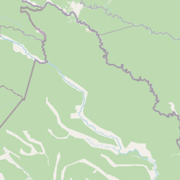
Map view of Huimeki Communal Reserve

Use this park location map to pinpoint Huimeki Communal Reserve in Peru, understand its exact geographic position, and read its mapped placement within the surrounding landscape more clearly.

Pigeon | © OpenStreetMap contributors

Location context for Huimeki Communal Reserve

Loreto Region
Natural feature types

Explore the Geographic Diversity of Huimeki Communal Reserve

Navigate through the structured index of named natural features associated with Huimeki Communal Reserve. MoriAtlas provides detailed landscape context to help you understand the riverine and forest geography of this vital Peruvian protected area.
Park atlas

Compare adjacent Amazonian reserves and connected borderland conservation corridors

Explore Parks Near Huimeki Communal Reserve and Surrounding Protected Landscapes

Browsing parks near Huimeki Communal Reserve reveals a continuous network of lowland rainforests spanning the upper Putumayo River basin. Examining these adjacent protected areas provides essential regional context for the ecological corridors uniting Peru, Colombia, and Ecuador.
Wildlife reserveLoreto Region
Park boundaries overlap#1 closest

South

Airo Pai Communal Reserve: Protected Wildlife and Amazonian Landscapes in Loreto, Peru

Analyzing the geographic character of this communal wildlife reserve

Airo Pai Communal Reserve serves as a pillar of conservation in the Loreto Region of northern Peru. This wildlife reserve features a complex hydrological mosaic of upland forest, palm-dominated swamps, and periodically flooded lowlands. By protecting these vital ecosystems, the reserve ensures the continuity of both indigenous cultural heritage and the habitats of iconic Amazonian aquatic species.

Area
2,478.88 km²
Established
2012
IUCN
VI
Relief
Lowland
National parkPeru
Park boundaries overlap#2 closest

Southeast

Güeppi-Sekime National Park: Protected National Park Atlas in Peru

Mapped landscape and regional geography of this Amazonian protected area.

Güeppi-Sekime National Park is a prominent protected area in Peru, recognized as a national park safeguarding a substantial expanse of tropical forest. Its landscape is characterized by diverse terrain, including rolling hills and seasonally inundated lowlands, vital for a rich tapestry of flora and fauna. The park's strategic location on the Ecuador border underscores its importance for transboundary conservation and ecological connectivity within the western Amazon basin. This page offers detailed information on its protected area identity, geographic context, and the mapped natural features that define this significant conservation landscape.

Area
2,036 km²
Established
2012
IUCN
II
Relief
Mixed relief
Wildlife reserveSucumbíos
28 km away#3 closest

West

Reserva de Producción de Fauna Cuyabeno: Geography of an Amazonian Wildlife Reserve

Explore protected boundaries and flooded landscape patterns in Sucumbíos

Reserva de Producción de Fauna Cuyabeno serves as a benchmark for Amazonian conservation, characterized by its extraordinary hydrological dynamics. The landscape comprises a network of blackwater rivers and semi-permanent lagoons that sustain an immense variety of species. As a protected area within Sucumbíos, it showcases the intricate relationship between seasonally submerged forests, terra firme terrain, and the vital river arteries that define this region.

Area
5,901.12 km²
Established
1979
IUCN
VI
Visitors
12K annual
National parkEcuador
73 km away#4 closest

Southwest

Yasuní National Park: Ecuador's Protected Landscape and Geographic Atlas Entry

Explore the mapped boundaries and regional terrain of this key national park.

Delve into the atlas-level details of Yasuní National Park, Ecuador's designated national park. This entry provides essential geographic context, focusing on the park's mapped boundaries and its role as a protected landscape within the region. Understand the specific terrain and protected area distribution that makes Yasuní National Park a significant point of geographic interest for atlas exploration.

Area
10,227.4 km²
Established
1979
IUCN
II
Relief
Lowland
Wildlife reserveSucumbíos
149 km away#5 closest

West

Reserva Biológica Limoncocha: Geography, Wetland Ecosystems, and Protected Boundaries

A vital Amazonian wildlife reserve in the Sucumbíos province.

Reserva Biológica Limoncocha is a distinctive wetland reserve defined by its intricate system of lagoons, rivers, and seasonal floodplains. Its geography provides a rare look at Amazonian biodiversity, ranging from elevated forest plateaus to permanently inundated palm swamps and vital black caiman habitats.

Area
46.13 km²
Established
1985
IUCN
VI
Relief
Lowland
National parkColombia
About 210 km away#6 closest

Northwest

Serranía de Los Churumbelos Auka-Wasi National Natural Park: Colombia's Protected Landscape Atlas

Mapped national park boundaries and regional geography.

Understand Serranía de Los Churumbelos Auka-Wasi National Natural Park through its geographic context and protected landscape features. This atlas view highlights the park's mapped boundaries and its significance within Colombia's natural geography, offering detailed insights into its protected status and regional terrain.

Area
562 km²
Established
2007
IUCN
II
Relief
Mountain
National parkHuila Department
About 211 km away#7 closest

Northwest

Cueva de los Guácharos National Natural Park: National Park and Protected Landscape Exploration

Understand its geographic setting within Huila Department.

Cueva de los Guácharos National Natural Park stands as a protected natural area within the atlas of Huila Department, Colombia. This page provides essential geographic context for the park, detailing its mapped boundaries and its status as a national park. Users can delve into the regional landscape, understand its place in the broader geographic context, and engage with structured data for protected area discovery. The focus remains on the park's physical presence and its atlas relevance, not visitor logistics.

Area
90.78 km²
Established
1960
IUCN
II
Relief
Mountain
Protected areaColombia
About 213 km away#8 closest

Northwest

Santuario Orito Indí-Andé Fauna and Flora Sanctuary: A Protected Area's Geographic and Landscape Identity in Colombia

Explore mapped boundaries and regional natural terrain context.

Gain insight into Santuario Orito Indí-Andé Fauna and Flora Sanctuary, a vital protected area contributing to Colombia's conservation landscape. This entry focuses on its distinct geographic characteristics and mapped territory. Understand the park's place within the national atlas and its contribution to regional geographic knowledge. It provides a structured foundation for exploring the natural terrain and protected boundaries specific to this important Colombian sanctuary.

Area
1,020 km²
Established
2008
Relief
Mountain
Access
Access unknown

Common questions about visiting, size, designation, and location context for Huimeki Communal Reserve

Huimeki Communal Reserve FAQs for park facts, access, geography, and protected area context

Find quick answers about Huimeki Communal Reserve, including protected-area facts, park geography, trail and visitor context, and how the park fits into its surrounding country and regional landscape.
MoriAtlas Explorer

Continue Your Protected Areas Search Across the Global Atlas

Deepen your exploration by continuing the structured search for national parks and protected areas worldwide. Utilize the comprehensive filtering capabilities to compare different conservation landscapes and refine your understanding of global park geography. Discover more about the distribution and characteristics of protected natural areas.

Global natural geography
