
Mori Atlas logo
Natural monumentHveravellir

A protected highland landscape defined by volcanic vents, hot springs, and glacial plateau geography

Hveravellir Natural Monument: Mapping Geothermal Terrain in the Central Icelandic Highlands

Hveravellir is a significant natural monument situated on the Kjölur plateau between the Hofsjökull and Langjökull glaciers. This geothermal field offers a unique view of Icelandic volcanic terrain, where steaming fumaroles, colorful mineral deposits, and sinter formations contrast with the surrounding dark lava fields of Kjalhraun. As a historic waypoint for highland travel, it represents a convergence of geological activity and centuries of cultural heritage in one of the most remote regions of Iceland.

geothermal areahot springshigh temperature fieldvolcanic plateauhighland IcelandKjölur route
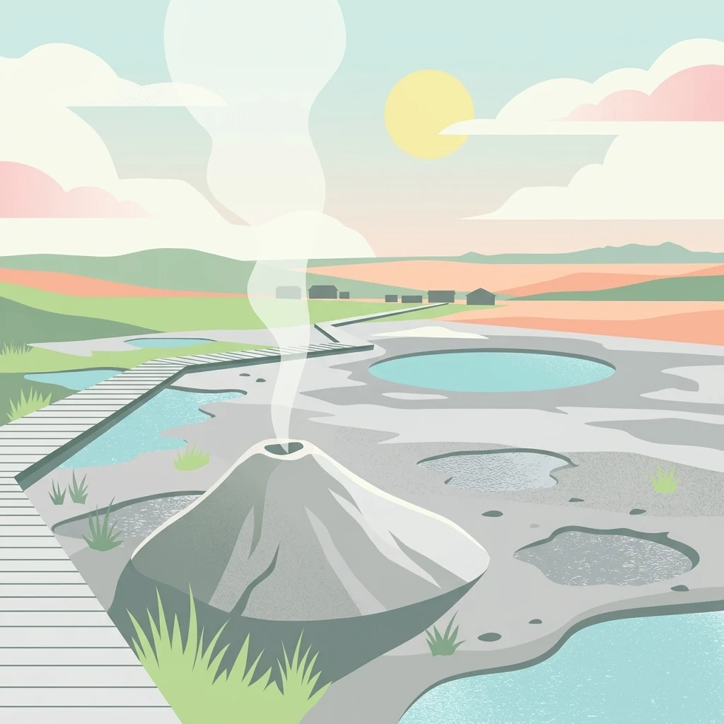
An illustration of a geothermal field with a smoking volcanic cone, several blue hot spring pools, and a wooden boardwalk crossing the landscape under a pale sun.

Hveravellir

Natural monument

Park overview

Structured park overview, official facts, and landscape profile for Hveravellir

Hveravellir park facts, protected area profile, and essential visitor context

Review the core facts for Hveravellir, including designation, size, terrain, visitor scale, habitats, and operating context in one park-focused overview.

About Hveravellir

Hveravellir occupies one of Iceland's most atmospheric highland locations, where geothermal heat meets a remote, glacially shaped interior. Sitting on the Kjölur plateau between two major ice caps, the area is part of the wider Oddnýjarhnjúkur–Langjökull volcanic system, and its thermal activity emerges along the northern edge of the extensive Kjalhraun lava shield. The combination of cold highland air, mineral-rich steam, and dark volcanic terrain gives the site a feeling that is both barren and alive.

The geothermal field itself spans around 2.5 square kilometers in its central portion, though related thermal features continue for several kilometers northward toward Beljandatungur and Kúlukvísl. Within the main area, hot springs occur in a wide variety of forms: geysers that erupt only in small, irregular bursts today, solfataras and fumaroles venting hissing steam, vigorous boiling pits, and lower-temperature warm springs used by travelers. Deposits of siliceous sinter and geyserite have built broad, low domes around both active and extinct geothermal centers, giving many of the features their characteristically rounded shapes and pale, chalky crusts.

Beyond its geology, Hveravellir is a cultural landmark. Its oldest written description dates to 1752, in the travel narrative of Eggert Ólafsson and Bjarni Pálsson, who described in detail the springs known today as Öskurhóll, Bláhver, and Rauðihver, among others. Centuries earlier, the outlaws Fjalla-Eyvindur and his wife Halla lived in the area during their exile, and visible remnants of their old dwelling site, including the ruin known as Eyvindarkofi, can still be found along with features of the springs that appear to have been used for cooking. A refuge hut was built on older foundations in 1922, with further huts added by the Icelandic Touring Association in 1938 and 1980, some of them heated directly by geothermal water; today these structures serve as a small tourist center within the protected area.

Quick facts and research context for Hveravellir

Hveravellir is a protected geothermal area in central Iceland, designated as a natural monument and functioning as a small nature reserve. It lies along the Kjölur highland route between the Hofsjökull and Langjökull glaciers, within the Oddnýjarhnjúkur–Langjökull volcanic system. The main geothermal area covers roughly 2.5 square kilometers and contains geysers, fumaroles, solfataras, boiling pits, and warm springs, with continuous thermal activity traceable for several kilometers to the north.

Protection and recognition

Analysis of terrestrial protected area data and recognition frameworks

Hveravellir Protection Status and Documented Conservation Scope

Terrestrial protection status records outline the documented management scope and official designation history established for Hveravellir. Conservation parameters outline foundational details regarding territorial safeguarding without assuming external international recognitions.

Protection details

Protection scope
Terrestrial
Transboundary protection
No
Park context

Deeper park guide and search-rich context for Hveravellir

Hveravellir history, landscape, wildlife, and travel context

Explore Hveravellir through its history, landscape character, ecosystems, wildlife, conservation priorities, cultural context, and seasonal travel timing in a structured park guide built for atlas discovery and search intent.

Why Hveravellir stands out

Hveravellir is best known for its diversity of geothermal features set in a stark highland landscape. Small erupting geysers, steaming fumaroles, brightly colored hot springs such as the famous Bláhver and Rauðihver, and broad, low sinter domes together create a vivid thermal scene at the edge of the lava field Kjalhraun. Equally distinctive is the area's role as a centuries-old highland refuge. Travelers have stopped at Hveravellir for over a thousand years, and the dramatic saga-era association with the outlaw Fjalla-Eyvindur adds a strong cultural layer to the site's natural appeal.
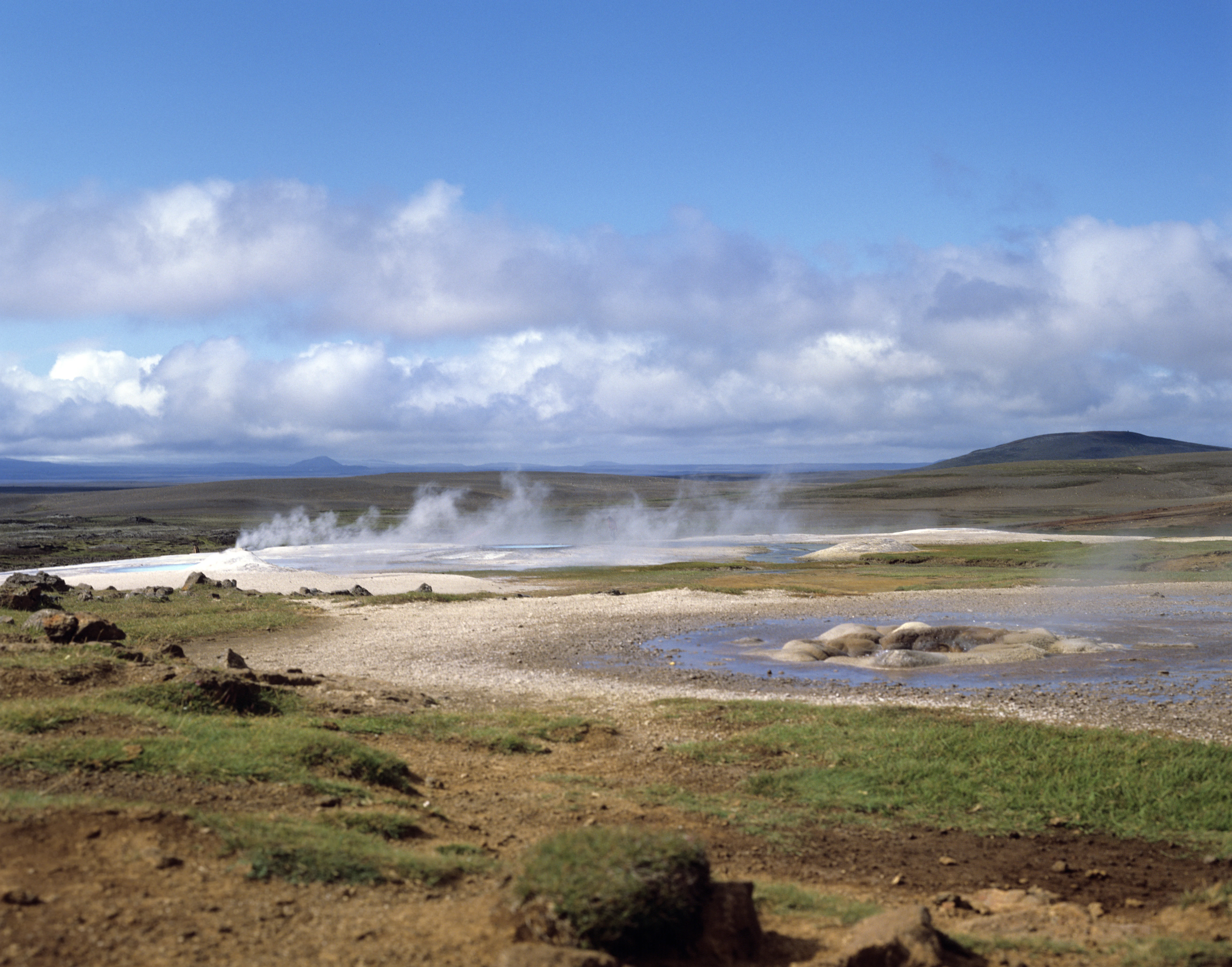
A wide view of the Hveravellir geothermal area in Iceland, with steam rising from vents and hot springs across a flat, sparse, and rocky landscape under a blue sky with scattered clouds.
The geothermal fields of Hveravellir, featuring steam vents and mineral-rich hot springs set against a stark Icelandic landscape.

Hveravellir history and protected-area timeline

Hveravellir has functioned as a highland waypoint for far longer than modern Iceland can document. References to it appear in old sagas, annals, and folklore, reflecting its longstanding role as one of the principal stopping places on the Kjölur route between northern and southern Iceland during the settlement period, roughly 1,100 to 1,200 years ago. Refuge structures have stood at the site since early times, even before formally recorded history.

The earliest detailed written description comes from 1752, when the naturalists and travelers Eggert Ólafsson and Bjarni Pálsson published their account of journeys around Iceland. They described the hot springs and noted one particular feature, later known as Öskurhóll, for its deep roaring and whistling sounds. The outlaw Fjalla-Eyvindur and his wife Halla lived at Hveravellir during their exile, and remains of their habitation, including the Eyvindarkofi ruin, are still visible in the area.

Modern infrastructure developed in the twentieth century. A turf-and-stone refuge hut was built on older foundations in 1922 and rebuilt in 1994. The Icelandic Touring Association, Ferðafélag Íslands, constructed an additional refuge in 1938, notable for being one of the few huts in the country heated directly by geothermal water. A new facility was added in 1980, and the two huts are still used by visitors. The Icelandic Meteorological Office operated a staffed weather observation station at Hveravellir from 1965 until well into the twenty-first century, when the station was automated. The hot spring pool used for bathing was created by damming the warm outflow in 1950, and the area was later formally designated a natural monument within Iceland's system of protected areas.

Hveravellir landscape and geographic character

Hveravellir's landscape is defined by the meeting of two great forces of Icelandic nature: volcanic activity and glacial ice. The thermal area sits on the Kjölur plateau at roughly 600 to 650 meters elevation, framed by the Hofsjökull glacier to the south and the Langjökull glacier to the north and west. This highland setting is open, treeless, and stark, with dark volcanic substrate stretching across much of the view.

The main thermal features lie along the northern margin of Kjalhraun, a large lava shield whose dark flows underlie much of the surrounding terrain. Against this somber backdrop, the geothermal zone appears as a vivid contrast: pale sinter terraces, steaming vents, and brightly colored pools. To the north, a related thermal corridor continues through the Breiðimelur area and onward toward Beljandatungur and Kúlukvísl, where hot springs gradually fade into warmer ground and low-temperature pools.

The terrain is essentially a high volcanic plateau carved and blanketed by past eruptions and glacial outwash. Because the area lies inside the Icelandic highlands, vegetation is sparse and dominated by mosses and low tundra plants, while the eye is drawn instead to the textures of lava, steam, and mineral crust. The result is a landscape that feels remote and exposed, yet constantly animated by heat rising from beneath the surface.
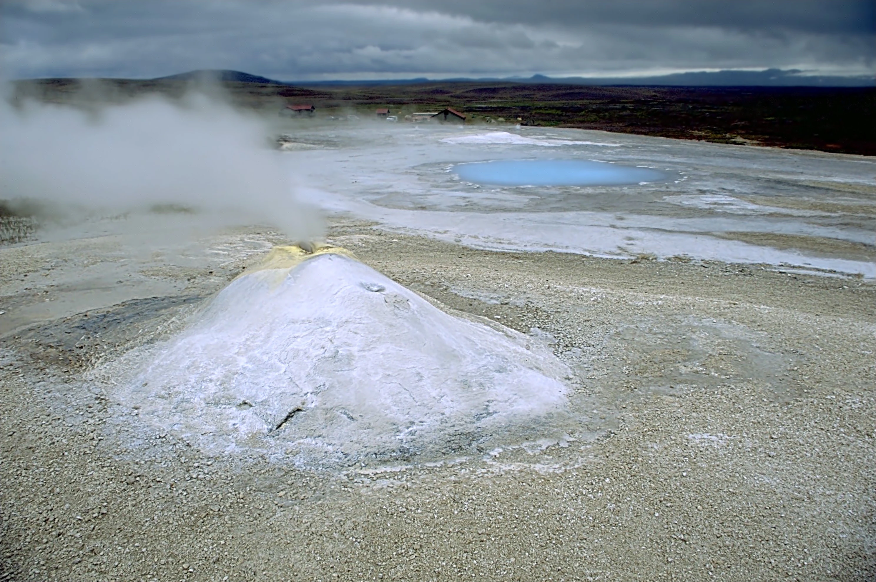
A wide angle view of a white, conical geothermal vent emitting steam, next to a small, bright blue hot spring pool on a flat, barren landscape under a cloudy sky.
A steaming geothermal vent and blue mineral-rich pool at the Hveravellir geothermal field in Iceland.

Hveravellir ecosystems, habitats, and plant life

As an interior highland thermal area, Hveravellir does not support the lush vegetation typical of Iceland's lowlands. The surrounding terrain belongs to the barren volcanic desert ecosystem of the central plateau, where plant cover is limited to mosses, lichens, low grasses, and the hardy dwarf shrubs typical of sub-arctic Icelandic tundra. This minimal vegetation emphasizes the bare textures of lava and ash that dominate the wider landscape.

The geothermal activity itself modifies the local environment in striking ways. Moisture, warmth, and mineral-rich runoff create microhabitats where specialized bacteria, algae, and mosses thrive, lending many springs their vivid blue, green, and rust-red coloration. Where steam vents release heat into otherwise cold ground, places like Breiðimelur maintain a unique patch of warm, damp terrain where travelers have traditionally baked rye bread in the hot earth, a practice that continues to shape how the area is understood culturally as well as ecologically.

Although Hveravellir is not a forested or species-rich reserve in the conventional sense, its protected status as a nature reserve and natural monument reflects the value placed on preserving this unusual combination of geothermal, volcanic, and high-altitude tundra ecosystems within one compact area.
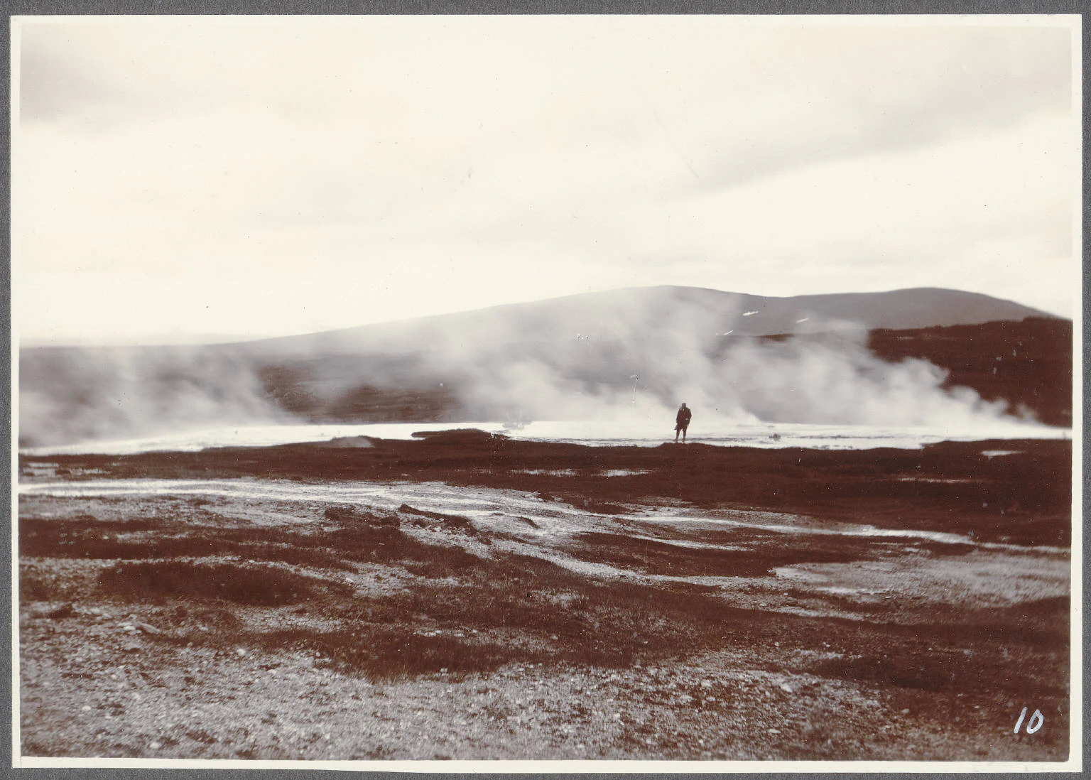
A sepia-toned vintage photograph showing a steaming geothermal area in Iceland with a lone figure standing near the vents.
Historical photograph of the geothermal field at Hveravellir, circa 1900.

Hveravellir wildlife and species highlights

Hveravellir is not primarily known for large mammal populations, and the surrounding highland terrain does not support dense wildlife communities. The remote plateau setting nevertheless forms part of the summer range for hardy Icelandic birdlife and grazing species, and travelers occasionally encounter ptarmigan and various highland waders in the moorland areas near the route.

The most distinctive biological character of the site is microbial rather than faunal. Heat-loving microorganisms flourish around the springs and steam vents, producing the bright bands of color that mark pools such as Bláhver and Rauðihver. These specialized communities are an important part of why the area is protected, even though they are not visible wildlife in the traditional sense.

Hveravellir conservation status and protection priorities

Hveravellir holds formal protection as a declared natural monument within Iceland's national system of protected areas, and is also managed as a small nature reserve. Its protected status reflects several overlapping values: the geological importance of its diverse high-temperature geothermal features, its position within the Oddnýjarhnjúkur–Langjökull volcanic system, and its cultural significance as one of the most historically documented highland sites in Iceland.

The conservation value of Hveravellir extends beyond its surface features. The continuous thermal belt stretching northward from the main hot spring area into Beljandatungur and toward Kúlukvísl represents a relatively intact example of a connected highland geothermal system, while the surrounding lava landscape of Kjalhraun preserves the volcanic context that sustains the activity. Together, the protected area safeguards both a distinctive geothermal habitat and the broader volcanic-plateau environment in which it occurs, an environment that is otherwise vulnerable to erosion, off-road traffic, and unregulated development pressures common in the Icelandic highlands.

Hveravellir cultural meaning and human context

Hveravellir carries a depth of cultural presence unusual for a remote thermal area. It appears repeatedly in the medieval sagas, annals, and oral traditions of Iceland, reflecting its long-standing role as a refuge on the Kjölur mountain route during the age of settlement. The site's appearance in early written description by Eggert Ólafsson and Bjarni Pálsson in 1752 marks it as one of the earliest scientifically observed geothermal landscapes in Iceland.

Perhaps the most famous cultural association is with Fjalla-Eyvindur, the Icelandic outlaw, who lived at Hveravellir with his wife Halla during their exile in the highlands. Ruins of their dwelling, including the so-called Eyvindarkofi, remain visible, as do features of the hot springs that appear to have been used for cooking. Preparing rye bread by burying it in the hot ground at Breiðimelur has become a living tradition linking visitors to centuries of highland travel culture, and the cluster of refuge huts, built in 1922, 1938, and 1980, some of them heated directly by geothermal water, continues this heritage of sheltering travelers passing through one of Iceland's most demanding interior routes.

Top sights and standout views in Hveravellir

Hveravellir's most compelling qualities are the concentration and variety of its geothermal features within a single highland setting, set against the broader context of Iceland's central volcanic plateau. The diversity of spring types, from small geysers to steam vents to warm bathing pools, combined with broad deposits of sinter and geyserite, gives the area a visual richness unusual even for Iceland.

Equally important is the layering of natural and cultural value: a nature reserve and natural monument that is also a site of saga-era significance, a documented scientific landmark from 1752, a former outlaw refuge, and a continuing waypoint on a major highland route. This combination of geological character, ecological protection, and human history makes Hveravellir a place where Iceland's volcanic interior and its long tradition of highland travel meet in one compact, accessible location.

Best time to visit Hveravellir

Hveravellir is a highland site, and seasonal conditions strongly shape both access and atmosphere. The Icelandic highland roads, including the Kjölur route on which the area sits, are generally only fully open during the summer months, roughly from late June through early September, when snow has melted and the gravel roads become passable for regular vehicles. Outside this window, conditions at the site shift dramatically, with deep snow, freezing temperatures, and reduced daylight transforming the thermal area into a far more severe environment.

Within the accessible highland season, late June through August offers the mildest conditions, the longest daylight hours, and the highest chance of experiencing both the geothermal features and the wider volcanic plateau in a single visit. Even in midsummer, however, conditions remain distinctly highland: visitors should expect cool temperatures, variable weather, and the possibility of strong wind. The geothermal activity itself is constant year-round, but the contrast between steaming ground and cold highland air is most striking during the cooler shoulder periods of the open season.

Monthly climate preview

Long-term monthly temperature ranges and precipitation averages measured at representative coordinates

Hveravellir Climate Normals, Annual Temperature and Precipitation Patterns

Hveravellir exhibits a measured annual climate cycle defined by subzero mean winter temperatures and positive mid-year thermal peaks alongside consistent daily precipitation. Examining the complete twelve-month record clarifies long-term meteorological normals across temperature extremes and precipitation rates.
Annual mean-2 °C
-7 °C6 °C
Jan-7°
Feb-7°
Mar-6°
Apr-4°
May
Jun
Jul
Aug
Sep
Oct-2°
Nov-5°
Dec-7°
Warmest month
July

5.8 °C

Coolest month
February

-7 °C

Wettest month
February

3.8 mm/day

Driest month
June

2.3 mm/day

Park location guide

Geography guide, regional context, and park location map for Hveravellir

Hveravellir park geography, regions, and map view in Iceland

Understand where Hveravellir sits in Iceland through a broader geographic reading of the surrounding landscape, nearby location context, and its mapped position within the national park landscape.

How Hveravellir fits into Iceland

Iceland is a Nordic island nation located between Europe and North America on the Mid-Atlantic Ridge. With a population of approximately 394,000 and an area of 103,125 km², it is one of the world's most sparsely populated countries. The country features dramatic volcanic terrain, extensive glaciers, geysers, and geothermal activity, all while maintaining a temperate climate warmed by the Gulf Stream.

Wider geography shaping Hveravellir in Iceland

Iceland is an island nation located in the North Atlantic Ocean between the Arctic Ocean and the Atlantic Ocean, situated on the Mid-Atlantic Ridge between Europe and North America. The interior consists of volcanic plateaus with sand and lava fields, while mountains and glaciers dominate the terrain. Numerous glacial rivers flow from the highlands through lowlands to the sea. The country sits at a latitude just south of the Arctic Circle.

Map view of Hveravellir

Use this park location map to pinpoint Hveravellir in Iceland, understand its exact geographic position, and read its mapped placement within the surrounding landscape more clearly.

Pigeon | © OpenStreetMap contributors

Explore detailed imagery of steaming vents, mineral hot springs, and high plateau terrain.

Hveravellir Photos and Landscapes: Visual Guide to Icelandic Geothermal Scenery

Visual records capture the striking contrasts of steaming fumaroles, colorful sinter terraces, and dark volcanic lava fields across the central highland plateau. Examining these protected wilderness views reveals the raw geological processes shaping the remote northern margin of Kjalhraun.

A wide view of the Hveravellir geothermal area in Iceland, with steam rising from vents and hot springs across a flat, sparse, and rocky landscape under a blue sky with scattered clouds.

A wide view of the Hveravellir geothermal area in Iceland, featuring a wooden boardwalk path stretching across a marshy, steaming landscape with low rolling hills in the background.

A wide angle view of a white, conical geothermal vent emitting steam, next to a small, bright blue hot spring pool on a flat, barren landscape under a cloudy sky.

A sepia-toned vintage photograph showing a steaming geothermal area in Iceland with a lone figure standing near the vents.

Park atlas

Compare nearby protected areas and connected volcanic landscapes across the region

Exploring Parks Near Hveravellir and Surrounding Icelandic Highlands

Browse protected areas and geothermal reserves located near Hveravellir along the central highland plateau. Regional comparisons reveal shared volcanic terrain, glacial boundaries, and protected landscapes across the surrounding interior.
Watercolor illustration showing a landscape with green fields, a winding path, pink flowers, and mountains in the background
National parkIceland
About 66 km away#1 closest

East

Vatnajökull National Park: Iceland's Expansive Protected Glacier and Volcanic Terrain

Mapped boundaries of a UNESCO World Heritage site dynamic with fire and ice.

Vatnajökull National Park offers a profound exploration of one of Earth's most dynamic natural environments. This Icelandic national park protects the vast Vatnajökull ice cap, a landscape shaped by active volcanoes and powerful glacial forces, creating a region of extraordinary geographic diversity. Discover the mapped terrain, from subglacial mountain ranges to dramatic caldera systems, and understand the unique protected area context of this significant European natural heritage.

Area
14,967 km²
Established
2008
IUCN
II
Relief
Mountain
Watercolor painting depicting a landscape with cliffs, a body of water, and distant hills under a light sky
National parkSouthern Region
About 87 km away#2 closest

Southwest

Þingvellir National Park: Witness Tectonic Plates and Ancient Icelandic Governance

Explore the rift valley and historic parliament site in Iceland's Southern Region.

Þingvellir National Park offers a singular opportunity for geographic discovery, situated in Iceland's Southern Region. This protected national park is globally recognized for its visible expression of the Mid-Atlantic Ridge, where the North American and Eurasian tectonic plates actively diverge, creating a dramatic rift valley. Moreover, Þingvellir served as the site of the Althing, Iceland's ancient parliament, making it a crucial historical landmark. Explore this landscape to understand both powerful geological processes and the foundations of Icelandic democratic history through its mapped terrain.

Area
92.7 km²
Established
1930
IUCN
II
Relief
Lowland
A watercolor illustration depicting a soft, green, rolling landscape with a river winding through it, framed by distant mountains.
Nature reserveIceland
About 145 km away#3 closest

Northeast

Mývatn Nature Reserve: Mapping the Volcanic Lakes and Tephra Formations of Northern Iceland

Protected wetland landscapes and volcanic rift zone geography.

Mývatn represents a complex of protected wetlands and volcanic landforms, including the Hverfjall explosion crater and the Skútustaðir pseudocraters. This geography-rich basin in northern Iceland offers insight into post-glacial volcanic activity and serves as an internationally significant breeding site for diverse bird populations within a compact, walkable terrain.

Area
37 km²
Relief
Upland
Climate
Polar
Access
Easy access
Watercolor illustration showing a mountain landscape with green valleys, pink mountains, and a winding river
National parkIceland
About 156 km away#4 closest

Southeast

Skaftafell National Park: Iceland's Accessible Protected Landscape with Glacial Terrain and Basalt Columns

Discover glacial landscapes and volcanic geology.

Skaftafell National Park is a vital protected area in Southeast Iceland, offering a unique atlas-level view of dramatic glacial landscapes. Located at the base of Vatnajökull, Europe's largest glacier, the park features accessible hiking trails that traverse outwash plains, birch woodlands, and glacial tongues like Skaftafellsjökull. Explore the iconic Svartifoss waterfall, framed by striking basalt columns, and understand the park's dynamic terrain shaped by volcanic activity and glacial processes, providing rich geographic context for protected landscape discovery.

Established
1967
IUCN
II
Scope
Terrestrial
Nature reserveIceland
About 182 km away#5 closest

South

Surtsey Nature Reserve: Mapping Volcanic Landscapes and Ecological Succession in Iceland

A pristine laboratory of North Atlantic volcanic terrain.

Surtsey represents a rare geological event, a volcanic island created by sustained eruptions and now protected as a strict nature reserve. The island acts as a primary research site for observing how life colonizes barren volcanic substrates, from mosses and insects to seabird colonies. Its mapped boundaries encompass dramatic basaltic lava flows and tephra deposits, providing a vital window into the formative processes of oceanic islands.

Area
1.4 km²
Established
1963
Relief
Upland
Climate
Subpolar
Watercolor illustration showing a river valley with hills and tents.
National parkIceland
About 184 km away#6 closest

Northeast

Jökulsárgljúfur National Park: Explore Iceland's Volcanic Canyon and Glacial River Protected Landscape

Mapped geography and terrain of a key northern Iceland protected area.

Jökulsárgljúfur National Park, located in northern Iceland, is celebrated for its striking volcanic canyon landscape carved by the powerful Jökulsá á Fjöllum glacial river. This protected area showcases a terrain shaped by ancient glacial outburst floods and volcanic forces, featuring notable geological formations like the Hljóðaklettar echo rocks and iron-colored hills. Understanding Jökulsárgljúfur National Park provides crucial insight into the unique regional geography and the atlas-driven exploration of Iceland's preserved natural heritage.

IUCN
II
Relief
Mountain
Access
Remote access
Scope
Terrestrial
A horizontal watercolor illustration depicting a soft, pink-hued coastal landscape with rolling hills, rocky outcrops, and a quiet bay.
National parkIceland
About 200 km away#7 closest

West

Snæfellsjökull National Park: Volcanic Stratovolcano and Coastal Protected Area in Iceland

Mapped geologic features, glacier terrain, and coastal volcanic landmarks.

Snæfellsjökull National Park features a unique assembly of volcanic landforms, including the iconic glacier-capped stratovolcano, the towering Lóndrangar basalt pinnacles, and symmetrical craters like Saxhóll. This protected area offers deep insights into the glacial and submarine origins of western Iceland through its diverse palagonite ridges and extensive lava plains.

Area
170 km²
Established
2001
Relief
Mountain
Scope
Terrestrial
Watercolor illustration of a mountain landscape with a glacier-capped peak and surrounding green fields
National parkIceland
About 201 km away#8 closest

West

Snæfellsjökull National Park: Geography and Protected Landscapes of Western Iceland

Glacial volcanoes, lava fields, and coastal topography.

Snæfellsjökull National Park sits at the western tip of the Snæfellsnes peninsula, creating a unique intersection of glacial, volcanic, and maritime environments. This database provides structured insights into the park's rugged terrain, including its moss-covered lava fields, sea-carved cliffs, and the namesake glacier that dominates the local landscape.

Established
2001
IUCN
II

Common questions about visiting, size, designation, and location context for Hveravellir

Hveravellir FAQs for park facts, access, geography, and protected area context

Find quick answers about Hveravellir, including protected-area facts, park geography, trail and visitor context, and how the park fits into its surrounding country and regional landscape.
MoriAtlas Explorer

Continue Your Protected Areas Search Across the Global Atlas

Deepen your exploration by continuing the structured search for national parks and protected areas worldwide. Utilize the comprehensive filtering capabilities to compare different conservation landscapes and refine your understanding of global park geography. Discover more about the distribution and characteristics of protected natural areas.

Global natural geography