Mori Atlas logo
National parkIndiana Dunes National Park

Discover the geographic identity and landscape context of this National Park in the USA.

Indiana Dunes National Park: Mapped Protected Area Boundaries and Regional Geography

Indiana Dunes National Park stands as a significant protected landscape within the United States of America. This detail page focuses on its precise geographic scope, offering insights into its mapped park boundaries and its role within the broader regional geography. Users can explore the natural terrain and landscape context that define this National Park, contributing to a structured understanding of conservation areas across the USA.

National ParksLake Michigan ShorelineDune EcosystemsWetland ComplexesBirdwatchingPrairie Remnants

Indiana Dunes National Park

National park

Park overview

Structured park overview, official facts, and landscape profile for Indiana Dunes National Park

Indiana Dunes National Park park facts, protected area profile, and essential visitor context

Review the core facts for Indiana Dunes National Park, including designation, size, terrain, visitor scale, habitats, and operating context in one park-focused overview.

About Indiana Dunes National Park

Indiana Dunes National Park represents a remarkable convergence of geological, ecological, and human history along the southern shore of Lake Michigan. The park's landscape tells a story spanning over 40,000 years, beginning with the Wisconsin Glacial Period when the Michigan Lobe of the continental glacier retreated northward, leaving behind the Valparaiso Moraine and a series of glacial lakes that would eventually form the modern Great Lakes. The distinctive dune formations that characterize the park emerged through the interplay of littoral currents, longshore drift, and wind action along the evolving Lake Michigan shoreline, creating the complex ridge and swale topography visible today. Beyond the iconic sand dunes, the park protects an impressive mosaic of wetlands including bogs, fens, marshes, and swamps that formed in the interdunal depressions between ancient beach ridges. Prairie remnants and oak savannas add further ecological diversity, representing communities that were once widespread throughout the Midwest but have largely disappeared from the region. The park's location at a biogeographic crossroads produces remarkable plant diversity, with Arctic species like bearberry growing alongside desert plants like prickly pear cactus, a combination found nowhere else in the country. This ecological significance prompted decades of conservation efforts beginning in the early 20th century, culminating in the park's establishment in 1966 and its elevation to national park status in 2019.

Quick facts and research context for Indiana Dunes National Park

Indiana Dunes National Park occupies a prominent position along the southern shore of Lake Michigan, approximately 50 miles east of Chicago. The park encompasses an extraordinary diversity of habitats within a relatively compact area, including active sand dunes, interdunal wetlands, bogs, fens, marshes, prairie remnants, oak savannas, and hardwood forests. Mount Baldy, standing at 123 feet, represents one of the tallest sand dunes on the southern Lake Michigan shoreline and serves as a dramatic example of a wandering dune that shifts position over time. The park's location places it within the central forest-grasslands transition ecoregion, creating unusual ecological conditions where Arctic and boreal plant species coexist alongside desert-adapted plants. The area holds significant historical importance as well, with the Bailly Homestead representing one of the oldest pioneer trading posts in northern Indiana.

Protection and recognition

Tracking terrestrial protection history, boundary scope, and national conservation status

Official Protection Status and Conservation Designation of Indiana Dunes National Park

Researchers can verify the official terrestrial protection status and established administrative boundaries of Indiana Dunes National Park. Understanding the formal designation history helps clarify how the surrounding Great Lakes shoreline landscapes are managed within national conservation frameworks.

Protection details

Protection scope
Terrestrial
Designated year
2019
Transboundary protection
No
Park context

Deeper park guide and search-rich context for Indiana Dunes National Park

Indiana Dunes National Park history, landscape, wildlife, and travel context

Explore Indiana Dunes National Park through its history, landscape character, ecosystems, wildlife, conservation priorities, cultural context, and seasonal travel timing in a structured park guide built for atlas discovery and search intent.

Why Indiana Dunes National Park stands out

Indiana Dunes National Park is best known for its spectacular and ecologically significant dune systems along Lake Michigan, particularly the towering Mount Baldy wandering dune. The park's botanical diversity is extraordinary, with over 1,400 vascular plant species representing the eighth-highest count among all national park units in the United States. The park contains several notable natural areas including Cowles Bog, a National Natural Landmark where pioneering ecologist Henry Chandler Cowles conducted foundational studies of ecological succession, and the Great Marsh, an extensive interdunal wetland system. The coexistence of northern boreal species with southern and even desert-adapted plants creates a botanical uniqueness that draws scientists and nature enthusiasts alike. The park also preserves significant historic sites including the Joseph Bailly Homestead, a National Historic Landmark representing early 19th-century fur trading in the region.

Indiana Dunes National Park history and protected-area timeline

The history of Indiana Dunes reflects a long human presence intertwined with the unique landscape. Native American communities utilized the dune area for seasonal hunting and gathering, with archaeological evidence pointing to Hopewell culture mound-building activities between 200 BCE and 800 CE. European settlement began in the early 19th century when Joseph Bailly established a trading post in 1822, becoming the earliest recorded settler in the dunes area. The community that developed around his homestead included early settlements like Chesterton, Porter, and Tremont. A notable chapter in the area's history was City West, a planned town intended to rival Chicago that was partly built in 1837 before failing during the national economic panic of that year. The movement to preserve the dunes began in earnest following Henry Chandler Cowles' 1899 publication on the unique flora of the dunes, which drew attention to the area's scientific importance. National Parks Director Stephen Mather held hearings in Chicago in 1916 regarding a Sand Dunes National Park. The disappearance of the Hoosier Slide, a massive dune whose sand was used for glass manufacturing, further galvanized preservation efforts. The Save the Dunes Council, led by Dorothy Richardson Buell and Hazel Hannell, launched a nationwide campaign that resulted in the establishment of Indiana Dunes National Lakeshore in 1966. Four subsequent expansion bills through 1992 increased the park to its current size. In 2019, legislation passed as part of the Consolidated Appropriations Act redesignated the unit as Indiana Dunes National Park, making it the nation's 61st national park and the first in Indiana.

Indiana Dunes National Park landscape and geographic character

The physical landscape of Indiana Dunes National Park presents a striking combination of coastal and interior features shaped by glacial and lacustrine processes. The dominant feature along the lakeshore is the series of dune ridges, some reaching heights exceeding 120 feet at Mount Baldy, which ranks among the tallest dunes on the southern shore of Lake Michigan. These dunes exhibit varying degrees of stability, from active wandering dunes that shift position annually to older, stabilized dunes now covered with vegetation. Behind the primary dune ridge lies a complex landscape of interdunal wetlands, including the extensive Great Marsh stretching over 12 miles, along with numerous bogs, fens, and ponds. The western portion of the park includes the Calumet Prairie, a remnant of the extensive grassland ecosystem that once covered much of the region, while the Hobart Prairie Grove preserves forested ravines and bur oak savanna. The park is transected by several waterways including Dunes Creek, which drains the Cowles Bog complex before entering Lake Michigan, the East Arm Little Calumet River, and Trail Creek. The underlying geology reflects the Wisconsin Glacial Period, with the Valparaiso Moraine serving as the dominant geological structure that created the varied terrain over approximately 40,000 years. Shoreline features include the Calumet Shoreline, the oldest visible shoreline of Lake Michigan, visible as a sand ridge along Ridge Road through Lake and Porter Counties.

Indiana Dunes National Park ecosystems, habitats, and plant life

The ecological character of Indiana Dunes National Park is defined by an exceptional diversity of habitats supporting a remarkable array of plant and animal species. The park lies within the central forest-grasslands transition ecoregion, where the influences of northern boreal ecosystems meet southern deciduous forest communities. According to the Kuchler potential vegetation classification, the park supports oak-hickory forest potential vegetation with an Eastern Hardwood forest form. The dune ecosystem itself represents a succession series from open beach through grass-dominated foredunes, then shrubland, to mature black oak forest, a process that ecological pioneer Henry Chandler Cowles first documented at Cowles Bog in the late 19th century. The wetland complexes within the park, including the Great Marsh, Cowles Bog, and Pinhook Bog, represent rare interdunal wetland habitats containing bog, fen, marsh, swamp, wet meadow, and pond communities. These wetlands support distinctive plant assemblages adapted to saturated, often acidic conditions. The prairie remnants, particularly at Hoosier Prairie and Calumet Prairie, preserve examples of the tallgrass prairie ecosystem that once dominated the Midwest. The presence of Arctic plant species like bearberry alongside desert species like prickly pear cactus demonstrates the unique biogeographic position of this area, where species from vastly different climatic zones converge.

Indiana Dunes National Park wildlife and species highlights

Indiana Dunes National Park supports a rich and diverse wildlife community reflecting the variety of habitats within its boundaries. The park has documented over 350 bird species, making it one of the most significant birding destinations in the Midwest and earning recognition from the Indiana Audubon Society. The Great Marsh and other wetland areas provide critical habitat for waterfowl including Canada geese, mallards, wood ducks, and coots, while the surrounding forests and prairie remnants support diverse songbird communities. Great blue herons and green herons frequent the wetlands, and the park provides habitat for raptors including hawks and turkey vultures. Mammalian residents include white-tailed deer, red fox, raccoons, opossums, and cottontail rabbits, with recent documentation of North American river otter returning to the area since 2011 and bobcat appearing since 2018. The park's aquatic habitats support 71 fish species, while the invertebrate community includes 296 insect species and 66 mollusk species. Several species at the park are of particular conservation concern, including the federally endangered Indiana bat, piping plover, and red knot, along with the threatened eastern massasauga rattlesnake. The plant community includes rare species such as Mead's milkweed and Pitcher's thistle, both federally listed as threatened.

Indiana Dunes National Park conservation status and protection priorities

Indiana Dunes National Park holds significant conservation importance as one of the most botanically diverse areas in the United States National Park System, with over 1,400 vascular plant species ranking eighth among all park units. The park preserves multiple National Natural Landmarks including Cowles Bog, where Henry Chandler Cowles conducted pioneering ecological research on succession in the late 19th century, providing foundational work for the science of ecology. The Great Marsh represents a major wetland restoration success story, with efforts beginning in 1998 to restore 500 acres by closing Derby Ditch and reestablishing natural hydrology. Several rare, threatened, and endangered species find sanctuary within the park, including two federally listed plant species, Mead's milkweed and Pitcher's thistle, along with endangered wildlife including the Indiana bat, piping plover, red knot, and eastern massasauga rattlesnake. The park's designation as a National Natural Landmark extends to Hoosier Prairie, a 430-acre tallgrass prairie preserve, and Pinhook Bog, an isolated quaking peat bog containing pitcher plants and other specialized wetland species. The park's conservation value is enhanced by its location within the central forest-grasslands transition, protecting an ecological interface that supports unusual species combinations found nowhere else in the country.

Indiana Dunes National Park cultural meaning and human context

The human history of the Indiana Dunes area spans thousands of years and reflects the diverse peoples who have lived along this stretch of Lake Michigan shoreline. Native American communities utilized the area for seasonal hunting and gathering, with archaeological evidence pointing to the Hopewell culture as the earliest permanent occupants, their presence marked by five groups of mounds documented within the dune area. Beginning in the 1500s, European exploration and trade introduced significant changes, with the dunes serving as a middle ground between eastern and western tribal territories. The historic Bailly Homestead, established by fur trader Joseph Bailly in 1822, represents one of the oldest pioneer trading posts in northern Indiana and stands as a National Historic Landmark within the park. The Chellberg Farm represents later agricultural settlement, with the park maintaining the property as a heritage farm. The Century of Progress Architectural District preserves five buildings from the 1933 Homes of Tomorrow Exhibition held during Chicago's World's Fair, representing innovative architectural designs of that era. Swedish immigration to Porter County from 1840 to 1920 created rural communities whose legacy is represented in the pending Swedish Farmsteads Historic District. The park also contains the Good Fellow Club Youth Camp, created in 1941 to provide recreational opportunities for children from industrial Gary.

Top sights and standout views in Indiana Dunes National Park

Indiana Dunes National Park offers visitors multiple outstanding features that distinguish it among national park units. The towering Mount Baldy, at 123 feet one of the tallest dunes on Lake Michigan's southern shore, represents a dramatic example of a wandering dune that moves approximately 4 feet annually, earning it the designation of a living dune. Cowles Bog, a National Natural Landmark and the sole remnant of the Central Dunes where Henry Chandler Cowles pioneered ecological succession studies, provides visitors with an opportunity to walk through multiple habitat types including bog, fen, marsh, and pond communities. The park's botanical diversity is exceptional, with over 1,400 vascular plant species including 90 threatened or endangered species. The Great Marsh, stretching 12 miles along the interior of the dune ridge, represents one of the largest interdunal wetlands in the region and has undergone significant restoration since 1998. The historic Bailly Homestead offers a tangible connection to early 19th-century frontier life, while the Century of Progress Architectural District preserves innovative architecture from the 1933 Chicago World's Fair. The park's position on Lake Michigan provides stunning views of the Chicago skyline from West Beach, particularly on clear days.

Best time to visit Indiana Dunes National Park

Indiana Dunes National Park offers year-round opportunities, though the best time to visit depends on interests. Spring brings exceptional wildflower displays, with May apple, buttercups, and violets blooming across the park, while ranger-led spring bloom hikes showcase the season's botanical highlights. Summer offers the warmest conditions for beach activities along the 15 miles of Lake Michigan shoreline, though visitors should be aware of rip current risks on days with strong north winds. Fall provides ideal conditions for hiking the 45 miles of trails, with comfortable temperatures and reduced crowds, while the changing foliage in the oak-hickory forests creates a distinctive autumn palette. Winter transforms the landscape dramatically, with shelf ice building along the beaches during cold months, creating an arctic dunescape that while beautiful presents safety hazards for visitors. The park's approximately 2 million annual visits are distributed throughout the year, with each season offering a different perspective on this ecologically diverse landscape. The shoulder seasons of spring and fall often provide the most comfortable conditions for hiking and wildlife observation, while avoiding both summer crowds and winter hazards.

Park guides

Targeted research questions and seasonal timing considerations for lakefront exploration

Indiana Dunes National Park Focused Guides and Expert Visitor Insights

Selected published guides provide structured answers regarding optimal timing for coastal exploration and dune habitat visits. Specific coverage addresses seasonal transitions and weather factors relevant to planning park itineraries.
Monthly climate preview

Charting the annual temperature range and precipitation cycle from long-term regional coordinates

Long-Term Climate Normals and Monthly Weather for Indiana Dunes National Park

Based on long-term data at a representative elevation of 215.57 meters, Indiana Dunes National Park features average monthly temperatures ranging from below minus four to over twenty-two degrees Celsius. Exploring the complete twelve-month profile provides precise precipitation and temperature averages to help analyze these environmental rhythms.
Annual mean10 °C
-4 °C23 °C
Jan-4°
Feb-2°
Mar
Apr
May15°
Jun20°
Jul23°
Aug22°
Sep18°
Oct12°
Nov
Dec-1°
Warmest month
July

22.9 °C

Coolest month
January

-4 °C

Wettest month
June

3.6 mm/day

Driest month
February

1.8 mm/day

Park location guide

Geography guide, regional context, and park location map for Indiana Dunes National Park

Indiana Dunes National Park park geography, regions, and map view in United States of America

Understand where Indiana Dunes National Park sits in United States of America through a broader geographic reading of the surrounding landscape, nearby location context, and its mapped position within the national park landscape.

How Indiana Dunes National Park fits into United States of America

The United States of America is a federal presidential republic and one of the world's largest countries by area and population. It consists of 50 states across a vast territory spanning multiple time zones, with its capital in Washington, D.C. and largest city in New York City. The nation has a diverse economy, influential political system, and significant cultural and military presence globally.

Wider geography shaping Indiana Dunes National Park in United States of America

The United States occupies a vast territory in North America, bordered by Canada to the north and Mexico to the south. The 48 contiguous states stretch from the Atlantic to the Pacific Ocean, while Alaska occupies the northwestern region and Hawaii is an archipelago in the Pacific. The country encompasses diverse terrain including the Rocky Mountains, Appalachian Mountains, Great Plains, and extensive river systems.

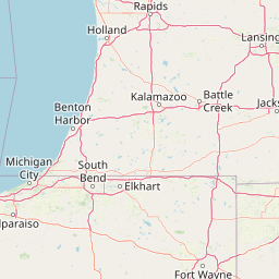
Map view of Indiana Dunes National Park

Use this park location map to pinpoint Indiana Dunes National Park in United States of America, understand its exact geographic position, and read its mapped placement within the surrounding landscape more clearly.

Pigeon | © OpenStreetMap contributors

Location context for Indiana Dunes National Park

IndianaLake CountyLaPorte CountyPorter County
Natural feature types

Explore the Named Natural Features of Indiana Dunes National Park

Access a structured collection of the dunes, marshes, and river features that define the geography of Indiana Dunes National Park. Use these resources to better understand the glacial landscape and ecological distribution within this protected region of the United States. Navigate the MoriAtlas data to trace the specific natural landmarks across the lakeshore.
Recorded earthquake history

Browse the Historical Earthquake Catalogue for Indiana Dunes National Park

Examine the recorded seismic history associated with the diverse landscapes of Indiana Dunes National Park. This collection from MoriAtlas provides a clear view of historical earthquake data, including event magnitude and proximity, for those interested in the regional seismic record of this protected area.

Indiana Dunes National Park Earthquakes

Catalogued events

1 event

Strongest magnitude

Magnitude 3.2

Most recent event

Nov 4, 2013

This history includes earthquakes recorded inside the park or within 50 km of its borders

Park atlas

Trace the geography of national parks and protected areas across the Great Lakes region and broader Midwest.

Explore Parks Near Indiana Dunes National Park and Discover Surrounding Protected Landscapes

After exploring the unique dune ecosystems and wetlands of Indiana Dunes National Park, browse other national parks and protected areas across the region. Compare the varied protected landscapes, tracing how glacial and lacustrine processes shaped diverse conservation efforts around the Great Lakes.
Protected landscapeWill County
59 km away#1 closest

West

Midewin National Tallgrass Prairie: A Protected Landscape Map in Will County Illinois

Federal tallgrass prairie restoration and ecological geography

Located in Will County, Midewin National Tallgrass Prairie is a cornerstone of American grassland conservation. This protected landscape combines diverse dolomite prairies, woodland corridors, and open grasslands, offering a deep look into the recovery of rare Midwestern ecosystems. The site functions as a living laboratory for research into native biodiversity and large-grazer ecological impact.

Area
73.76 km²
Established
1996
Relief
Lowland
Climate
Temperate
Marine protected areaWisconsin
About 260 km away#2 closest

North

Wisconsin Shipwreck Coast National Marine Sanctuary: Mapping Underwater Protected Cultural Landscapes

Underwater maritime archaeology and Lake Michigan basin geography.

Spanning 82 miles along the Wisconsin coastline, the Wisconsin Shipwreck Coast National Marine Sanctuary protects a unique underwater archaeological landscape. Cold, fresh water ensures the remarkable preservation of dozens of historic schooners and steamships, providing a deep look into the maritime economy of the upper Midwest. The sanctuary area offers insights into glacial lakebed terrain, bathymetric mapping, and the complex underwater geography of Lake Michigan.

Area
2,490 km²
Established
2021
Relief
Lowland
Climate
Temperate
Protected landscapeIndiana
277 km away#3 closest

South

Hoosier National Forest: Geographic Overview of Indiana Protected Wilderness and Woodlands

Mapping the karst terrain and forest corridors of southern Indiana.

Hoosier National Forest defines the landscape of southern Indiana with its rolling unglaciated hills and ridge systems. Discover the mapped geography of this protected area, including its rare prairie-like barrens, sandstone cliff formations, and the designated Charles C. Deam Wilderness. This overview focuses on the spatial extent and diverse topographic features that distinguish this forest from the surrounding Midwest plains.

Area
826.78 km²
Established
1961
Relief
Upland
Climate
Temperate
National parkMichigan
334 km away#4 closest

North

Sleeping Bear Dunes National Lakeshore: Atlas, Maps, and Protected Landscape Geography

Great Lakes freshwater coast and glacial dune systems

Sleeping Bear Dunes National Lakeshore showcases the unique intersection of glacial geology and freshwater ecology. This protected area features massive dunes resting on ancient glacial deposits, backed by beech and maple forests. The geographic scope includes the vast shoreline of Lake Michigan, inland waters such as Glen Lake, and the distinct maritime history found across the remote North and South Manitou Islands.

Area
288.13 km²
Established
1970
IUCN
III
Visitors
1.5M annual
National parkOntario
346 km away#5 closest

East

Point Pelee National Park: Ontario's National Park Atlas and Protected Landscape Explorer

Mapped geography and protected area context within Ontario.

Point Pelee National Park is a designated national park in Ontario, Canada, offering a unique focus for geographic discovery. This entry details its protected landscape and mapped boundaries, essential for understanding its place within regional park atlases. Explore the core geographic identity of Point Pelee National Park and its significance as a protected natural area.

Area
15 km²
Established
1918
IUCN
II
Visitors
491.1K annual
Nature reserveOhio
About 362 km away#6 closest

East

Old Woman Creek National Estuarine Research Reserve: Protected Lake Erie Estuary

Northern Ohio coastal wetland and research landscape.

Old Woman Creek National Estuarine Research Reserve represents a vital freshwater estuary on the Lake Erie shore. This reserve protects a unique combination of marsh, swamp forest, and barrier beach, providing significant insight into the natural function of Great Lakes coastal systems in northern Ohio.

Area
2.32 km²
Established
1980
Relief
Lowland
Climate
Temperate
Protected landscapeMichigan
About 396 km away#7 closest

Northeast

Huron, Manistee National Forests: Geography, Protected Land, and Michigan Landscape Atlas

Exploration of glacial terrain, river basins, and coastal wilderness.

The Huron, Manistee National Forests stand as a significant protected landscape in northern Michigan, featuring a vast network of inland rivers and lakes. This atlas entry provides geographic context on its glacial geology, the rare dune ecosystems along Lake Michigan, and the distribution of pine-dominated forest habitats across the two administrative units.

Area
3,960 km²
IUCN
VI
Relief
Lowland
Climate
Temperate
National parkMissouri
404 km away#8 closest

Southwest

Gateway Arch National Park: National Park Geographic Atlas and Map Boundaries

Explore protected landscape context and regional setting.

Gateway Arch National Park represents a unique protected landscape within Missouri, contributing to the broader national park atlas. This entry focuses on its specific geographic identity and mapped boundaries, offering structured data for understanding its role. Discover the factual landscape context and regional importance of Gateway Arch National Park for informed geographic exploration.

Area
0.78 km²
Established
2018
IUCN
II
Visitors
1.2M annual

Common questions about visiting, size, designation, and location context for Indiana Dunes National Park

Indiana Dunes National Park FAQs for park facts, access, geography, and protected area context

Find quick answers about Indiana Dunes National Park, including protected-area facts, park geography, trail and visitor context, and how the park fits into its surrounding country and regional landscape.
MoriAtlas Explorer

Continue Your Protected Areas Search Across the Global Atlas

Deepen your exploration by continuing the structured search for national parks and protected areas worldwide. Utilize the comprehensive filtering capabilities to compare different conservation landscapes and refine your understanding of global park geography. Discover more about the distribution and characteristics of protected natural areas.

Global natural geography