

Mori Atlas logo
Nature reserveIndio Maíz Biological Reserve

Analyzing the ecological boundaries and riverine geography of this protected forest reserve

Indio Maíz Biological Reserve: A Vast Protected Lowland Rainforest in Southern Nicaragua

(Reserva Biológica Indio Maíz)

Indio Maíz Biological Reserve encompasses over 3,180 square kilometers of humid tropical rainforest in southeastern Nicaragua. As a cornerstone of the Mesoamerican Biological Corridor, this landscape features a complex network of river systems and forest habitats under indigenous Rama-Kriol administration. This resource examines the reserve's geographic significance, protected status, and its role as a vital habitat for neotropical wildlife.

lowland rainforesttropical rainforestCaribbean lowlandsprotected forestbiodiversity hotspotindigenous territory

Indio Maíz Biological Reserve

Nature reserve

Park overview

Structured park overview, official facts, and landscape profile for Indio Maíz Biological Reserve

Indio Maíz Biological Reserve park facts, protected area profile, and essential visitor context

Review the core facts for Indio Maíz Biological Reserve, including designation, size, terrain, visitor scale, habitats, and operating context in one park-focused overview.

About Indio Maíz Biological Reserve

Indio Maíz Biological Reserve is one of the defining conservation areas of Central America's Caribbean watershed. Sitting where Nicaragua narrows toward the San Juan River and the Costa Rican border, the reserve encompasses an enormous expanse of lowland tropical rainforest that once stretched across much of the isthmus. It is widely cited as a key building block of the proposed Mesoamerican Biological Corridor, a transboundary initiative connecting protected forests from southern Mexico through Panama. Within Nicaragua, it sits as a counterpart to the northern Bosawás Biosphere Reserve, together representing the country's two largest remaining lowland rainforest complexes.

Ecologically, Indio Maíz sits within the Caribbean lowland forest track that also includes Costa Rica's Barra del Colorado Wildlife Refuge and Tortuguero National Park immediately to the south. The reserve's flora mirrors these forests, featuring species such as Astronium graveolens, Carpotroche platyptera, and Posoqueria latifolia, with a varied understory of palms like Bactris hondurensis and Cryosophila warscewiczii, large aroids including Dracontium gigas, and abundant epiphytes, ferns, and lycopods. Soils are nutrient-poor ultisols with limited drainage, and the climate is hot and extremely wet, with sustained rainfall across most of the year.

Culturally and legally, the reserve is unusual: roughly seventy percent of its area is governed by the Rama-Kriol Territorial Government on behalf of indigenous Rama and Kriol communities. Following revolutionary and later constitutional reforms, these communities gained de facto and eventually documented stewardship over the land, adding a distinctive layer of co-management to what would otherwise be a strictly state-administered protected area. This dual framework has shaped access policy, with most of the reserve closed to independent visitors and only limited guided boat tours allowed from El Castillo and Greytown.

The reserve's profile is increasingly shaped by the tension between its ecological importance and external pressures. Oil palm and cattle ranching expansion since the early 2010s, returning colonization within the forest, the windfall damage from Hurricane Otto in 2016, and large forest fires in 2018 have all raised concerns about the long-term integrity of the reserve. These pressures have, in turn, strengthened the role of indigenous and community coalitions in advocating for its protection.

Quick facts and research context for Indio Maíz Biological Reserve

Indio Maíz Biological Reserve is a lowland tropical rainforest reserve situated in the Río San Juan Department and South Caribbean Coast Autonomous Region of southeastern Nicaragua, spilling across the border toward Costa Rica via the San Juan River. It is one of the largest protected lowland forest blocks in Central America and ranks as Nicaragua's second largest lowland rainforest reserve, forming a critical component of the proposed Mesoamerican Biological Corridor. Its biodiversity includes more recorded species of trees, birds, and insects than all of Europe, alongside strongholds for jaguars, Baird's tapirs, and great green macaws.

The reserve was first established in 1990, reorganized as part of the Southeast Nicaragua Biosphere Reserve in 1999, and later separated into four smaller protected areas. About seventy percent of its area falls within territory administered by the Rama-Kriol Territorial Government, making indigenous land tenure an integral part of its governance context. Its climate is humid tropical rainforest with around 26°C mean annual temperature and more than 4,000 mm of rainfall per year.

Protection and recognition

Documented terrestrial protection scope, designation history, and international recognition records.

Indio Maíz Biological Reserve Protection Status and Recognized Designations

Indio Maíz Biological Reserve maintains a documented terrestrial protection scope within its primary conservation boundaries. Analysis of official records provides verified metrics on designated status, management scope, and international recognition metrics.

Protection details

Protection scope
Terrestrial
Transboundary protection
No
Park context

Deeper park guide and search-rich context for Indio Maíz Biological Reserve

Indio Maíz Biological Reserve history, landscape, wildlife, and travel context

Explore Indio Maíz Biological Reserve through its history, landscape character, ecosystems, wildlife, conservation priorities, cultural context, and seasonal travel timing in a structured park guide built for atlas discovery and search intent.

Why Indio Maíz Biological Reserve stands out

Indio Maíz is best known as one of Central America's most important surviving blocks of lowland Caribbean rainforest, with a species richness that has been described as exceeding all of Europe in trees, birds, and insects combined. It functions as a major stronghold for flagship Neotropical wildlife such as jaguars, Baird's tapirs, great green macaws, scarlet macaws, and harpy eagles, while the bordering San Juan River supports the world's only known freshwater shark population, the Nicaragua shark (bull shark). Equally distinctive is the reserve's status as part of the proposed Mesoamerican Biological Corridor and its overlap with indigenous Rama and Kriol administered territory. Together these factors make Indio Maíz a key reference site for both tropical rainforest conservation and models of shared indigenous-led stewardship of large protected forests in Central America.
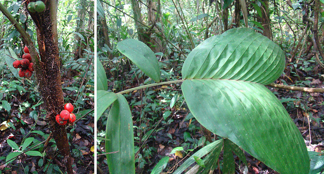
A split image showing the trunk of a palm tree with clusters of bright red fruit on the left and a close up of its broad, pleated green leaves on the right, set against a blurred tropical forest background.
A close up view of the trunk and leaves of a Biscoyol palm in the Indio Maíz Biological Reserve.

Indio Maíz Biological Reserve history and protected-area timeline

The origins of Indio Maíz Biological Reserve lie in the wave of protected-area creation that swept through Nicaragua in the late twentieth century. The territory was first designated in 1990 as part of the Áreas Naturales Protegidas del Sureste de Nicaragua during the first Sandinista government, and it was later reorganized in 1999 under the Reserva de Biosfera del Sureste de Nicaragua. Following the prior reorganization of the northern Bosawás Biosphere Reserve in 1997, the southeastern biosphere was eventually split into four smaller protected areas, one of which became today's Indio Maíz Biological Reserve.

A second, parallel history shaped the reserve: the indigenous land rights revolution. In 1987 the revolutionary Nicaraguan government granted autonomous rights to the Rama and Kriol peoples over much of this southeastern territory, leading to the establishment of the Rama-Kriol Territorial Government. After 2002, in response to international pressure, this commitment was translated into formal land deeds, placing roughly seventy percent of the reserve under indigenous governance. The resulting arrangement created an unusual legal regime that combined state-protected-area status with indigenous territorial administration, an arrangement that continues to define access, management, and conservation debate around Indio Maíz.

The reserve's recent history is dominated by escalating threats. Internal colonization in the mid-1990s led to the establishment of villages inside the reserve, which were evicted in 2001, only for new encroachment to emerge from around 2010 onward. By 2015 several hundred families were believed to live within the forest, driving agricultural expansion that has affected the northern and western flanks. In 2015 and 2018, conservation and indigenous organizations formed coalitions such as the Unión de Organizaciones Ambientalistas and the Batallón Cívico Indio-Maíz to coordinate responses to deforestation. Natural shocks compounded the pressure: Hurricane Otto crossed the reserve in November 2016, and the dead wood left in its wake likely fueled the major forest fires of April 2018 that burned thousands of hectares.

Indio Maíz Biological Reserve landscape and geographic character

Indio Maíz is a vast, flat to gently rolling expanse of Caribbean lowland rainforest. Its elevation is consistently low, and its terrain is shaped more by rivers, seasonal flooding, and soil drainage than by dramatic relief. The nutrient-poor ultisols that underlie the reserve are heavy, often poorly drained, and prone to waterlogging during the long wet season, reinforcing the dominance of moist forest vegetation across the landscape.

The reserve's hydrology is central to its identity. The San Juan River forms its western and southwestern boundary with Costa Rica, while within the reserve a network of smaller rivers, including the Bartola and Indian rivers, dissects the forest and provides the only practical access routes. To the southeast lies the coast near Monkey Point, marking the reserve's interface with the Caribbean Sea. The river network is also essential for wildlife movement and creates a mosaic of flooded and better-drained forest types.

The climate overlays all of this with intense and sustained rainfall. Mean annual temperatures hover around 26°C, and rainfall exceeds 4,000 mm per year, with a long wet season stretching roughly from May to January and a shorter, slightly drier interval from February to April. The result is a perpetually humid, deeply vegetated landscape where rivers, swamps, and multilayered forest close in around any traveler moving by boat.

Indio Maíz Biological Reserve ecosystems, habitats, and plant life

The ecological character of Indio Maíz is defined by its status as one of the largest intact blocks of Caribbean lowland forest remaining in Central America. Floristically, it bears strong similarity to the Costa Rican forests of Barra del Colorado and Tortuguero, sharing many canopy, subcanopy, and understory species. The canopy and emergent layers feature trees such as Astronium graveolens, Carpotroche platyptera, Luehea seemanii, Mansoa hymenaea, Posoqueria latifolia, and Sorocea affinis, while the understory is dominated by palms including Bactris hondurensis, Cryosophila warscewiczii, and Desmoncus species.

Below the palms, the reserve hosts a rich herbaceous layer with common species such as Heliconia latispatha, and giant aroids like Dracontium gigas, one of the largest members of the Neotropical Araceae. Epiphytes, ferns, and lycopods are abundant throughout, with Selaginella eurynota and related species contributing to the dense vertical stratification. The combination of extremely high rainfall, poor soils, and continuous canopy cover produces a structurally complex forest whose layers support very high biodiversity.

The reserve's ecological importance extends beyond its forests. Wetlands, river corridors, and the San Juan River shoreline provide habitat for aquatic species including tarpon and the freshwater Nicaragua shark, while the broader forest supports reptiles such as crocodiles, iguanas, bushmaster snakes, and turtles. The unbroken extent of the forest makes Indio Maíz a vital refuge for species that require large, contiguous tracts of undisturbed habitat to survive.

Indio Maíz Biological Reserve wildlife and species highlights

Wildlife is the most celebrated dimension of Indio Maíz. The reserve records some 65 mammal species including four wild cat species, 221 bird species, 55 reptile species, 34 amphibian species, and 149 insect species. Among its most emblematic mammals are jaguars, pumas, Baird's tapirs, white-headed capuchins, howler monkeys, spider monkeys, sloths, armadillos, raccoons, collared peccaries, and manatees. Baird's tapirs and jaguars in particular maintain important population strongholds here, making the reserve significant for the long-term survival of these species in Central America.

The avifauna is exceptionally rich. Great green macaws and scarlet macaws are among the most visually striking residents, while the harpy eagle finds important habitat among the tall emergents of the forest. Other notable birds include the three-wattled bellbird, the great curassow, and the royal flycatcher. Reptiles are represented by American crocodiles, iguanas, turtles, and formidable snakes such as the bushmaster Lachesis muta and the palm pit viper Bothriechis schlegelii.

Amphibians add another layer of ecological richness, with brightly colored poison dart frogs such as Oophaga pumilio and the toad Incilius melanochlorus, recorded in the reserve as one of only a handful of Nicaraguan locations. The aquatic fauna is equally significant, with tarpon common in coastal and riverine waters and the San Juan River hosting the world's only documented freshwater population of the Nicaragua shark, a population of bull sharks that has prompted Nicaragua to ban freshwater shark fishing due to declining numbers.

Indio Maíz Biological Reserve conservation status and protection priorities

Indio Maíz holds an outsized conservation profile relative to many other Central American reserves because it preserves one of the largest contiguous blocks of Caribbean lowland rainforest left on the isthmus. It serves as a cornerstone of the proposed Mesoamerican Biological Corridor, a transboundary network intended to maintain ecological connectivity from Mexico through Panama. Within Nicaragua it pairs with the larger Bosawás Biosphere Reserve to the north to represent the country's two great remaining rainforests, making it critical for the country's biodiversity commitments and regional connectivity goals.

Conservation significance extends to specific species: the reserve supports essential populations of jaguars, Baird's tapirs, great green macaws, harpy eagles, and other rare or range-restricted species. Its freshwater shark population in the San Juan River is also of global scientific interest. The combination of forest extent, species richness, and intact predator and large mammal populations places Indio Maíz among the highest-priority sites for tropical forest conservation in the region.

The reserve's conservation reality, however, is under serious pressure. Agricultural expansion, particularly oil palm plantations and cattle pasture on the northern and western flanks, is the dominant threat, amplified by recolonization of the interior since 2010. Hurricane Otto in 2016 and the forest fires of 2018 added acute shocks, with thousands of hectares burned in a single event. The conservation response has come from a coalition that includes the Rama-Kriol Territorial Government, Fundación del Río, cocoa cooperatives, tourism cooperatives, and municipal water and sanitation networks, organized as the Unión de Organizaciones Ambientalistas and later the Batallón Cívico Indio-Maíz, reflecting both the seriousness of the threats and the unusual indigenous-led dimension of conservation governance here.

Indio Maíz Biological Reserve cultural meaning and human context

Indio Maíz is unusual among large tropical reserves in that indigenous territorial rights are deeply woven into its governance. The revolutionary Nicaraguan government granted autonomy to the Rama and Kriol peoples in 1987, and from 2002 onward, in response to international pressure, this autonomy was backed by formal land deeds. Approximately seventy percent of the reserve now falls within the territory administered by the Rama-Kriol Territorial Government, blending state protected-area frameworks with indigenous stewardship.

The Rama people, after whom the reserve is indirectly named, are one of the small indigenous groups of southeastern Nicaragua, with traditional livelihoods tied to the rivers and forests of this region. Kriol communities, descended in part from Afro-Antillean populations in the Caribbean lowlands, form the second main indigenous constituency of this territory. Together they shape how the reserve is accessed, used, and protected, with visitors relying in many cases on Rama guides and sometimes staying in traditional wooden Rama huts along waterways such as the Indian River upstream from Greytown.

This cultural layer has become increasingly active in contemporary conservation politics. Indigenous environmental organizations, including the Unión de Organizaciones Ambientalistas and later the Batallón Cívico Indio-Maíz, emerged as leading voices calling for stronger enforcement against illegal colonization and agricultural incursions. Their activism has tied the reserve's future directly to questions of indigenous land rights, autonomy, and the role of traditional communities in protecting Central America's remaining rainforests.

Top sights and standout views in Indio Maíz Biological Reserve

Indio Maíz Biological Reserve stands out as one of Central America's largest surviving lowland tropical rainforests, with biodiversity levels for trees, birds, and insects reportedly exceeding those of all of Europe. It anchors the proposed Mesoamerican Biological Corridor and is home to strongholds for jaguars, Baird's tapirs, great green macaws, harpy eagles, and the rare freshwater Nicaragua shark in the bordering San Juan River.

What makes the reserve especially distinctive is the combination of scale, ecological richness, and indigenous co-governance. Roughly seventy percent of its area is administered by the Rama-Kriol Territorial Government, making it one of the more prominent protected forests in the region with formal indigenous land tenure. The convergence of global biodiversity importance, transboundary conservation frameworks, and indigenous stewardship gives Indio Maíz a significance that extends well beyond its already substantial natural heritage.

Best time to visit Indio Maíz Biological Reserve

Given its humid tropical rainforest climate, Indio Maíz is one of the wettest protected areas in the region, with annual rainfall exceeding 4,000 mm and a long wet season running roughly from May to January. The slightly drier interval from February to April tends to be the more comfortable window in terms of rainfall, although conditions remain humid and warm year-round with mean temperatures around 26°C.

Access is fundamentally shaped by water levels and riverine transport rather than by traditional hiking seasons, since most visitation is by boat. Travelers planning a visit should generally expect a tropical rainforest experience at any time of the year, with the February to April period offering comparatively reduced rainfall but no dry season in the conventional sense. The broader ecological significance of the reserve is also seasonal in subtle ways, with fruiting and flowering patterns and consequently wildlife activity tied to the rainfall cycle rather than to a single visitor-friendly high season.

Monthly climate preview

Long term average temperature and monthly precipitation patterns across the protected reserve

Indio Maíz Biological Reserve Climate Normals and Weather by Month

Indio Maíz Biological Reserve records measured annual temperature and precipitation shifts across twelve distinct monthly intervals from NASA sampling points. Detailed twelve month climate profiles allow researchers to examine long term thermal rhythms and rainfall variations across the protected landscape.
Annual mean26 °C
25 °C28 °C
Jan25°
Feb26°
Mar27°
Apr28°
May27°
Jun26°
Jul26°
Aug26°
Sep26°
Oct25°
Nov25°
Dec25°
Warmest month
April

27.6 °C

Coolest month
December

24.7 °C

Wettest month
October

7.9 mm/day

Driest month
March

0.7 mm/day

Park location guide

Geography guide, regional context, and park location map for Indio Maíz Biological Reserve

Indio Maíz Biological Reserve park geography, regions, and map view in Nicaragua

Understand where Indio Maíz Biological Reserve sits in Nicaragua through a broader geographic reading of the surrounding landscape, nearby location context, and its mapped position within the national park landscape.

How Indio Maíz Biological Reserve fits into Nicaragua

Nicaragua is a Central American country spanning 130,375 km² with a population of approximately 6.7 million. It borders Honduras, Costa Rica, the Caribbean Sea, and the Pacific Ocean. The official language is Spanish, and the currency is the Córdoba. Known for its agricultural productivity and cultural diversity, Nicaragua has a history dating back to indigenous civilizations before Spanish conquest in the 16th century.

Wider geography shaping Indio Maíz Biological Reserve in Nicaragua

Nicaragua occupies a strategic position in Central America, bordered by Honduras to the north, the Caribbean Sea to the east, Costa Rica to the south, and the Pacific Ocean to the west. The country also shares maritime borders with El Salvador and Colombia. The terrain includes coastal plains, volcanic highlands, and interior valleys. Lake Managua and Lake Nicaragua are major freshwater bodies.

Map view of Indio Maíz Biological Reserve

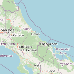
Use this park location map to pinpoint Indio Maíz Biological Reserve in Nicaragua, understand its exact geographic position, and read its mapped placement within the surrounding landscape more clearly.

Pigeon | © OpenStreetMap contributors

Location context for Indio Maíz Biological Reserve

Río San Juan Department
Recorded earthquake history

Review Recorded Seismic Events Near Indio Maíz Biological Reserve

Examine the historical catalogue of earthquakes documented in the vicinity of Indio Maíz Biological Reserve. This MoriAtlas collection provides transparent access to regional seismic data, allowing for a better understanding of recorded activity patterns around this protected lowland forest area.

Indio Maíz Biological Reserve Earthquake History

Catalogued events

35 events

Strongest magnitude

Magnitude 6.2

Most recent event

Aug 7, 2023

This history includes earthquakes recorded inside the park or within 50 km of its borders

Visual reference of lowland rainforest habitats and protected river environments

Indio Maíz Biological Reserve Photos and Landscape Scenery

Visual documentation captures the dense canopy, river networks, and humid forest habitats that define the Indio Maíz Biological Reserve. Photographic records provide clear insight into the complex terrain and protected ecosystems of this Caribbean lowland stronghold.

A split image showing the trunk of a palm tree with clusters of bright red fruit on the left and a close up of its broad, pleated green leaves on the right, set against a blurred tropical forest background.

Park atlas

Compare adjacent lowland rainforest reserves and regional conservation corridors

Exploring Parks Near Indio Maíz Biological Reserve and Protected Landscapes

Browsing other protected areas near Indio Maíz Biological Reserve reveals connected Caribbean lowland forest ecosystems and regional wildlife corridors. Comparing these neighboring habitats provides deeper context on tropical biodiversity strongholds and transboundary conservation networks.
National parkLimón Province
23 km away#1 closest

Southeast

Tortuguero National Park: Protected Landscape and Regional Geographic Context

National Park mapped in Limón Province, Costa Rica.

Delve into Tortuguero National Park, a significant national park situated in Limón Province, Costa Rica. This entry offers detailed insights into its protected area status, mapped geographic extent, and its role within the regional natural landscape context. Ideal for users seeking a structured atlas view of protected lands and their geographical distribution, providing foundational data for understanding this specific conservation landscape.

Area
312 km²
Established
1975
IUCN
II
Visitors
10K annual
National parkHeredia Province
36 km away#2 closest

South

Braulio Carrillo National Park: Costa Rica's Protected Landscape in Heredia Province

National Park Boundaries and Regional Geography Exploration

Braulio Carrillo National Park represents a vital protected area, offering deep insights into its geographic setting within Heredia Province. This entry provides a focused view on the park's mapped boundaries and its identity as a national park, contributing essential data for regional geography and landscape atlas exploration. Understand the character of its protected terrain and its place within the broader mapped context.

Area
475.8 km²
Established
1978
IUCN
II
Relief
Mountain
National parkAlajuela Province
52 km away#3 closest

South

Juan Castro Blanco National Park: National Park Boundaries and Alajuela Province Geography

Explore the protected landscape within north-central Costa Rica.

Juan Castro Blanco National Park offers a distinct protected landscape for geographic study within Alajuela Province. This national park serves as a key entity for exploring mapped boundaries, understanding local terrain, and situating its protected area within the broader atlas of Costa Rica. Delve into the specific geographic context and natural landscape features that define this important park.

Area
145 km²
Established
1992
IUCN
II
Relief
Mountain
National parkAlajuela Province
58 km away#4 closest

South

Poás Volcano National Park: National Park Protected Landscape in Alajuela Province

Mapped park boundaries and regional terrain context.

Poás Volcano National Park represents a vital protected landscape within Costa Rica's Alajuela Province. This detail page offers an atlas-centric view, emphasizing the park's geographic identity, its specific mapped boundaries, and its significance as a national park. Explore the natural terrain and understand the regional context of this protected area, ideal for geographic discovery and landscape exploration.

Area
65 km²
Established
1971
IUCN
II
Relief
Mountain
National parkCosta Rica
65 km away#5 closest

Southwest

Arenal Volcano National Park: Costa Rica National Park Atlas and Mapped Terrain

Detailed geography and protected landscape context for a Costa Rican national park.

Gain a structured understanding of Arenal Volcano National Park, a protected natural area situated in Costa Rica. This page provides detailed geographic information, focusing on its mapped boundaries and landscape characteristics. It serves as a key resource for exploring the park's specific regional context and its role within the country's network of protected lands.

Area
121.24 km²
Established
1991
IUCN
II
Relief
Mountain
National parkCosta Rica
71 km away#6 closest

Southwest

Tenorio Volcano National Park: National Park Geographic Context in Costa Rica

Map exploration of its volcanic terrain and protected area boundaries.

Delve into Tenorio Volcano National Park, a key national park entity situated within Costa Rica's vibrant geography. This page provides detailed atlas-style information, focusing on the park's mapped boundaries, its characteristic volcanic landscape, and its role in understanding the broader distribution of protected areas across the country. Understand the park's specific geographic identity and its contribution to the nation's natural heritage.

Area
129 km²
Established
1976
IUCN
II
Relief
Mountain
National parkCosta Rica
78 km away#7 closest

South

Turrialba Volcano National Park: Mapped Geography and Protected Landscape Context in Costa Rica

Explore the protected area's natural terrain and regional atlas placement

Turrialba Volcano National Park is a key protected landscape in Costa Rica, offering distinct geographic features and environmental context for atlas exploration. This page details the park's mapped boundaries and its significance as a national park, providing a foundation for understanding its place within the country's diverse natural terrain. Discover the unique geographic identity of this protected area and its role in the regional landscape.

Area
16 km²
Established
1955
IUCN
II
Relief
Mountain
National parkCartago Province
81 km away#8 closest

South

Irazú Volcano National Park: National Park Protected Area Atlas

Mapped Boundaries and Volcanic Terrain

Irazú Volcano National Park stands as a distinct protected area within the landscape of Cartago Province, Costa Rica. This page provides an atlas-centric view, detailing the park's mapped boundaries and its identity as a national park. Explore the volcanic geography and regional context, understanding its contribution to the protected lands of Central America.

Area
20 km²
Established
1955
IUCN
II
Relief
Mountain

Common questions about visiting, size, designation, and location context for Indio Maíz Biological Reserve

Indio Maíz Biological Reserve FAQs for park facts, access, geography, and protected area context

Find quick answers about Indio Maíz Biological Reserve, including protected-area facts, park geography, trail and visitor context, and how the park fits into its surrounding country and regional landscape.
MoriAtlas Explorer

Continue Your Protected Areas Search Across the Global Atlas

Deepen your exploration by continuing the structured search for national parks and protected areas worldwide. Utilize the comprehensive filtering capabilities to compare different conservation landscapes and refine your understanding of global park geography. Discover more about the distribution and characteristics of protected natural areas.

Global natural geography