

Mori Atlas logo
Wildlife reserveInnoko Wilderness

A vast subarctic wilderness transition zone featuring sprawling muskeg, river networks, and tundra habitats

Innoko Wilderness: Mapping the Protected Wetlands and Boreal Forests of Interior Alaska

Innoko Wilderness represents a significant protected tract within interior Alaska, encompassing over one million acres of water-rich terrain. This landscape serves as a vital transition zone where dense boreal spruce forests merge with open tundra, sustained by the hydrological influence of the Yukon and Innoko Rivers. The area provides essential habitat for subarctic wildlife, with its network of wetlands, marshes, and slow-moving river corridors remaining largely undisturbed.

wilderness areasubarctic ecosystemwetlandsmuskegboreal forest transitiontundra

Innoko Wilderness

Wildlife reserve

Park overview

Structured park overview, official facts, and landscape profile for Innoko Wilderness

Innoko Wilderness park facts, protected area profile, and essential visitor context

Review the core facts for Innoko Wilderness, including designation, size, terrain, visitor scale, habitats, and operating context in one park-focused overview.

About Innoko Wilderness

Innoko Wilderness sits in a remote part of central to western Alaska, anchored within the Innoko National Wildlife Refuge in the Yukon-Koyukuk Census Area. Although the nearest town, Unalakleet, lies to the west along the Bering Sea coast, the Wilderness is far more strongly tied to the inland river systems and lowland ecosystems of the Alaskan interior than to any coastal community. Its remoteness and the absence of road access leave it as one of the more intact, lightly visited wilderness tracts in the state.

Ecologically, Innoko Wilderness captures the character of subarctic lowlands in transition. Boreal forest elements, especially islands of black spruce with a moss, lichen, and shrub understory, mix with open muskeg, marshy lake systems, and tundra-like flats. This blending of habitat types makes the area ecologically rich even by Alaskan standards. More than half of the Wilderness falls within wet or semi-wet terrain, and the mosaic of water, forest patches, and open ground creates habitat for a wide range of species.

The Wilderness is also closely connected to two of Alaska's significant rivers, the Yukon and the Innoko. These rivers not only shape the surrounding vegetation and hydrology but also support a pattern of small, privately owned subsistence camps along their banks. Alaska Native communities have historically used portions of this landscape for hunting and fishing, and the area carries cultural and subsistence value alongside its conservation significance.

As a congressionally designated wilderness area established in 1980, Innoko Wilderness carries the protections typical of the National Wilderness Preservation System, preserving its character against development or degradation. Its management by the U.S. Fish and Wildlife Service ties its identity closely to that of the broader Innoko National Wildlife Refuge, and reinforces its role in safeguarding subarctic wildlife, intact hydrological systems, and one of the more substantial examples of Alaska's transitional taiga-tundra landscape.

Quick facts and research context for Innoko Wilderness

Innoko Wilderness is a congressionally designated wilderness area located in the Yukon-Koyukuk Census Area of Alaska and managed by the U.S. Fish and Wildlife Service. It was established in 1980 and sits within the southeastern portion of the Innoko National Wildlife Refuge.

The Wilderness spans about 1,240,000 acres, making it one of the more substantial wilderness areas in Alaska. More than half of its surface is wetland, including muskeg, marshes, lakes, and slow-moving waterways ringed by stands of black spruce. The area functions ecologically as a transition between boreal interior forest and open western tundra, and it supports mammal populations such as beaver, moose, caribou, and bear, along with large seasonal gatherings of waterfowl and shorebirds.

Protection and recognition

Documented terrestrial protection scope, establishment year, and international recognition facts

Innoko Wilderness Protection Status and Official Designation History

Innoko Wilderness maintains a documented terrestrial protection status established in 1980 across its designated wilderness boundaries. Structured conservation records provide clear reference data regarding management scope and official area designations.

Protection details

Protection scope
Terrestrial
Designated year
1980
Transboundary protection
No
Park context

Deeper park guide and search-rich context for Innoko Wilderness

Innoko Wilderness history, landscape, wildlife, and travel context

Explore Innoko Wilderness through its history, landscape character, ecosystems, wildlife, conservation priorities, cultural context, and seasonal travel timing in a structured park guide built for atlas discovery and search intent.

Why Innoko Wilderness stands out

Innoko Wilderness is known first for its sheer size and the dominance of wetland systems across the landscape. Muskeg, marshes, lakes, and braided river corridors cover more than half of the area, creating a sprawling, water-rich environment typical of interior and western Alaska. It is also recognized for functioning as a major ecological transition zone. Boreal spruce forest and open tundra intermingle here, supporting unusually diverse habitats for mammals and waterfowl. The Wilderness plays an important role as breeding and summer habitat for Canada geese and a wide variety of other waterbirds, and is sustained by the Innoko and Yukon Rivers, which shape the surrounding land.
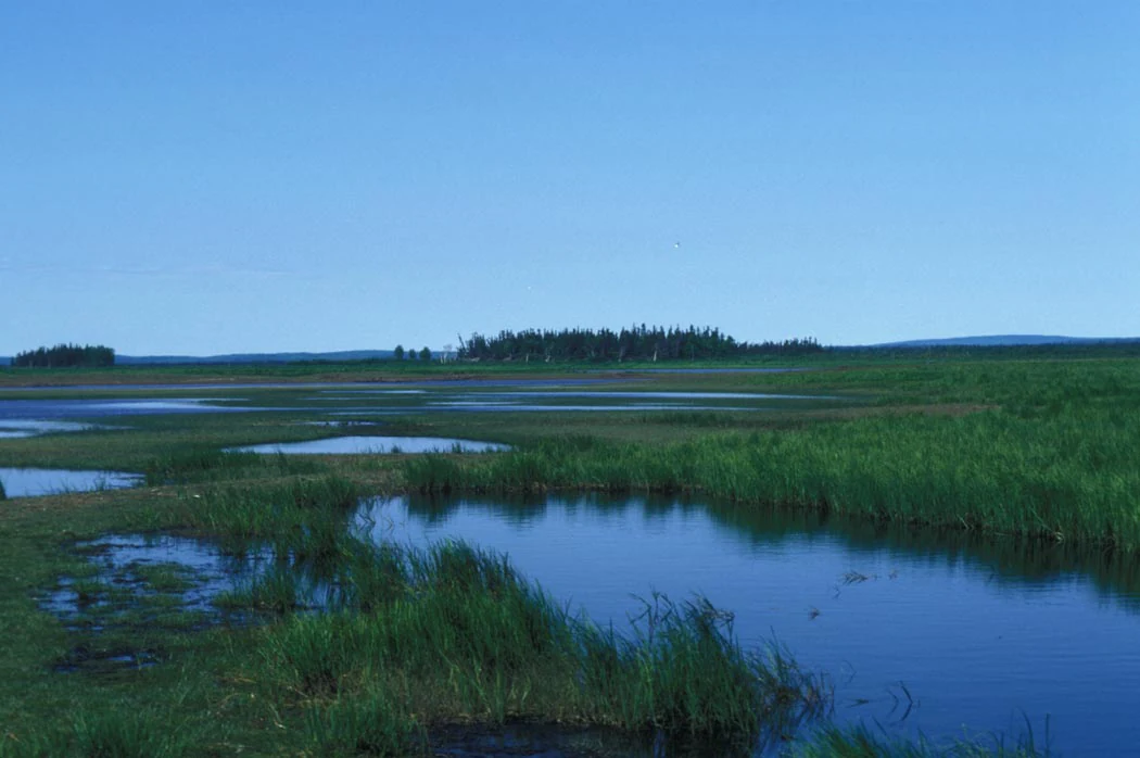
A wide, low-angle shot of a sprawling, flat wetland landscape with small, calm pools of water scattered among dense green grasses under a clear blue sky, with a line of coniferous trees in the distance.
A summer view of the marshy wetlands and boreal forest of Innoko Wilderness, Alaska.

Innoko Wilderness history and protected-area timeline

Innoko Wilderness was formally designated by the United States Congress in 1980 as part of the National Wilderness Preservation System. Its designation came during a notable expansion of federal wilderness protections in Alaska and reflected growing recognition of the state's intact subarctic ecosystems.

The Wilderness was established within the existing Innoko National Wildlife Refuge, indicating that even before wilderness designation, this landscape had already been identified as important for wildlife conservation. The U.S. Fish and Wildlife Service, which manages the refuge, also took on the responsibility of administering the wilderness overlay within it.

Beyond the administrative history, the surrounding land has long supported traditional use by Alaska Native communities, including periodic hunting and fishing camps along the Yukon and Innoko Rivers. These subsistence uses continue within the broader refuge, though they remain distinct from the formal federal wilderness designation established in 1980.

Innoko Wilderness landscape and geographic character

The landscape of Innoko Wilderness is defined overwhelmingly by water and low-relief terrain. Muskeg, marshes, shallow lakes, slow streams, and the broad floodplains of the Innoko and Yukon Rivers dominate the terrain. More than half of the Wilderness consists of these wetland systems, which together create a vast, water-saturated environment typical of lowland interior and western Alaska.

Rising above the wetlands are scattered islands of black spruce forest, often standing on slightly better drained ground between marshy basins. These spruce stands carry a soft understory of mosses, lichens, and low shrubs, giving them a classic boreal appearance. Between the wetlands and the spruce islands, the ground transitions gradually into tundra-like openings characteristic of western Alaska.

The Innoko and Yukon Rivers carve through or border the Wilderness, contributing to the network of riparian corridors and producing numerous small river islands, meanders, and sloughs. Their influence on hydrology, vegetation, and habitat diversity is substantial, and along their banks sit traditional subsistence camps that reflect long-standing human presence in an otherwise wild landscape.

Innoko Wilderness ecosystems, habitats, and plant life

Innoko Wilderness represents one of the more ecologically significant transitional landscapes in Alaska. It sits at the meeting point between the boreal forest ecosystems of the interior and the open tundra of western Alaska, producing a mosaic of spruce-dominated forest, muskeg, marsh, open water, and tundra-like terrain all within a single large protected area.

The dominance of wetland habitats, including muskeg, marsh, lakes, rivers, and streams, gives the Wilderness a strongly hydrological character. These water-rich environments, combined with scattered islands of black spruce and their moss, lichen, and shrub understory, create structurally diverse habitat that supports a high variety of wildlife and ecological processes.

Because the Wilderness is so heavily shaped by water and by the gradual transition between forest and tundra, it serves as a useful example of an intact subarctic lowland ecosystem remaining largely unmodified by large-scale human activity. The blend of aquatic, wetland, and boreal conditions within one connected landscape contributes significantly to its ecological value.

Innoko Wilderness wildlife and species highlights

Innoko Wilderness is particularly notable for its large mammal populations. The area supports well over 20,000 beavers, whose presence reflects the abundance of wetland habitat and woody vegetation in the form of willow and spruce. The Wilderness is also home to moose and caribou, both of which are emblematic of subarctic Alaska, along with black bears, brown bears, red foxes, coyotes, lynx, otters, wolves, and wolverines. Together, these species represent a strong representation of interior Alaskan predator and ungulate fauna.

The birdlife of the Wilderness is equally significant. An estimated 65,000 Canada geese summer in the area each year, joined by an additional 380,000 or more waterfowl and shorebirds during the breeding season. Among these are northern pintails, scaups, northern shovelers, scoters, American wigeons, red-necked grebes, lesser yellowlegs, and Hudsonian godwits, illustrating the importance of the wetland complex as migratory and breeding habitat.

The combination of abundant wetlands, sparse human presence, and intact predator-prey dynamics gives Innoko Wilderness considerable value for wildlife conservation. Its populations and habitats are representative of the broader interior and western Alaskan wilderness ecosystems that depend on large, connected, and lightly disturbed landscapes.

Innoko Wilderness conservation status and protection priorities

Innoko Wilderness was designated by the U.S. Congress in 1980 specifically to preserve the wilderness character of its landscape, complementing its location within the Innoko National Wildlife Refuge. As a congressionally designated wilderness area, it carries the protections associated with the National Wilderness Preservation System, restricting activities that would compromise its wild and undeveloped condition.

Its conservation significance is closely tied to the dominance of wetlands and the ecological transition between boreal forest and tundra. By protecting a large, contiguous tract of muskeg, marsh, river corridor, and spruce island habitat, the Wilderness helps safeguard hydrological systems, waterfowl breeding grounds, and mammal populations that depend on intact subarctic environments.

The area is also important because of its role in sustaining species that require large, undisturbed ranges. Wolverines, wolves, bears, caribou, and moose all benefit from the scale and remoteness of the protected area. Management by the U.S. Fish and Wildlife Service ties conservation priorities directly to wildlife and habitat integrity, and the Wilderness reinforces the refuge's broader mission of maintaining functioning ecosystems in Alaska.

Innoko Wilderness cultural meaning and human context

Innoko Wilderness lies in a region of Alaska with a long history of use by Alaska Native communities. Along the Yukon and Innoko Rivers, numerous small, privately owned subsistence camps are used periodically for hunting and fishing by local residents. These camps reflect an ongoing relationship between people and the land that predates the formal establishment of the Wilderness by decades.

The presence of subsistence camps is a distinctive cultural feature of this landscape. Although the Wilderness itself emphasizes protection of natural conditions, the surrounding refuge and river corridors also support traditional lifestyles tied to fish, waterfowl, moose, caribou, and other game. This combination of subsistence use and wilderness protection is characteristic of many protected landscapes in interior and western Alaska, where conservation goals and indigenous land-use traditions overlap.

Top sights and standout views in Innoko Wilderness

Innoko Wilderness stands out for the overwhelming presence of wetland habitat. Muskeg, marsh, lakes, and slow rivers cover more than half of the area, creating one of the more water-rich wilderness tracts in Alaska and supporting an exceptionally high beaver population.

The Wilderness is also notable for its role as a transition zone between boreal interior forest and western tundra, with islands of black spruce interspersed through open muskeg. Its large summer populations of Canada geese and other waterfowl, alongside intact communities of moose, caribou, wolves, bears, and wolverines, reinforce its profile as one of the more ecologically significant wilderness areas in the state.

Best time to visit Innoko Wilderness

Summer is the most practical and ecologically expressive season in Innoko Wilderness. Snowmelt fills the wetlands, lake systems expand, and the Yukon and Innoko River corridors come alive with waterfowl breeding activity. This is when tens of thousands of Canada geese and hundreds of thousands of additional waterfowl and shorebirds use the area, and when mammals such as moose, caribou, and bears are most active across the landscape.

Late spring through early fall offers the mildest conditions and the broadest wildlife viewing opportunities, though conditions remain distinctly subarctic, with cool temperatures, mosquitoes, and unpredictable weather. Winters are long, cold, and snow-bound, transforming the Wilderness into a darker, quieter environment dominated by frozen muskeg and limited daylight, and access becomes significantly more difficult.

Monthly climate preview

Track measured temperature ranges and monthly precipitation patterns across the year

Innoko Wilderness Climate Normals and Long Term Weather by Month

Representative coordinates record long term temperature extremes from severe winter lows to mild summer maximums alongside consistent monthly precipitation. Detailed twelve month climate profiles reveal complete historical baseline records for this protected landscape.
Annual mean-2 °C
-20 °C14 °C
Jan-20°
Feb-15°
Mar-12°
Apr-2°
May
Jun13°
Jul14°
Aug12°
Sep
Oct-2°
Nov-13°
Dec-18°
Warmest month
July

14.1 °C

Coolest month
January

-20.4 °C

Wettest month
August

2.8 mm/day

Driest month
March

0.9 mm/day

Park location guide

Geography guide, regional context, and park location map for Innoko Wilderness

Innoko Wilderness park geography, regions, and map view in United States of America

Understand where Innoko Wilderness sits in United States of America through a broader geographic reading of the surrounding landscape, nearby location context, and its mapped position within the national park landscape.

How Innoko Wilderness fits into United States of America

The United States of America is a federal presidential republic and one of the world's largest countries by area and population. It consists of 50 states across a vast territory spanning multiple time zones, with its capital in Washington, D.C. and largest city in New York City. The nation has a diverse economy, influential political system, and significant cultural and military presence globally.

Wider geography shaping Innoko Wilderness in United States of America

The United States occupies a vast territory in North America, bordered by Canada to the north and Mexico to the south. The 48 contiguous states stretch from the Atlantic to the Pacific Ocean, while Alaska occupies the northwestern region and Hawaii is an archipelago in the Pacific. The country encompasses diverse terrain including the Rocky Mountains, Appalachian Mountains, Great Plains, and extensive river systems.

Map view of Innoko Wilderness

Use this park location map to pinpoint Innoko Wilderness in United States of America, understand its exact geographic position, and read its mapped placement within the surrounding landscape more clearly.

Pigeon | © OpenStreetMap contributors

Location context for Innoko Wilderness

Alaska

Visual exploration of subarctic wetlands, boreal forests, and western tundra

Innoko Wilderness Landscape Photos and Scenery

Visual records capture the vast wetlands, meandering rivers, and black spruce islands that define the remote terrain of Innoko Wilderness. Examining these protected area views reveals the ecological transition zone where interior boreal forest meets open Alaskan tundra.

A wide, low-angle shot of a sprawling, flat wetland landscape with small, calm pools of water scattered among dense green grasses under a clear blue sky, with a line of coniferous trees in the distance.

Park atlas

Compare surrounding subarctic wilderness tracts and regional wildlife refuges

Explore Parks Near Innoko Wilderness and Related Protected Landscapes in Alaska

Browse other protected areas near Innoko Wilderness to examine connected subarctic wetlands and boreal forest transition zones. Extending your geographic comparison reveals how vast river networks and lowland terrain shape the wider regional ecosystem.
National parkAlaska
About 348 km away#1 closest

Southeast

Lake Clark National Park and Preserve National Park: Alaska's Protected Landscape Discovery

Mapping the geographic context and protected park boundaries.

Lake Clark National Park and Preserve stands as a protected national park in Alaska, offering a distinct geographic identity for atlas exploration. Delve into its role as a protected landscape, examining its mapped presence within the Alaskan region. This resource provides structured insights into the park's protected area status and its contribution to the understanding of natural terrain and regional geography.

Area
16,308.9 km²
Established
1980
IUCN
V
Visitors
19.8K annual
National parkAlaska
About 404 km away#2 closest

East

Denali National Park and Preserve: Detailed Protected Landscape and Map Exploration in Alaska

Explore its mapped boundaries and Alaskan regional geography.

Understand Denali National Park and Preserve as a distinct protected landscape within Alaska's vast geography. This park detail page offers insights into its mapped boundaries, natural terrain, and its contribution to the regional atlas of protected areas. Discover the geographic context that defines this significant national park, providing a foundation for detailed map-based exploration and understanding of its conservation significance.

Area
24,464 km²
Established
1917
IUCN
V
Visitors
427.6K annual
National parkNorthwest Arctic Borough
About 431 km away#3 closest

North

Kobuk Valley National Park: Protected National Park with Regional Geography Context

Explore mapped boundaries and natural terrain within Northwest Arctic Borough.

Kobuk Valley National Park serves as a primary protected landscape within the Northwest Arctic Borough, Alaska. This entry facilitates detailed atlas exploration of its specific geography, mapped protected boundaries, and the natural terrain that defines its character as a designated national park. Understand its place within the broader regional landscape for comprehensive geographic discovery.

Area
7,084.9 km²
Established
1980
IUCN
II
Visitors
17.6K annual
National parkAlaska
About 474 km away#4 closest

South

Katmai National Park and Preserve: Alaska National Park Atlas and Protected Landscape Exploration

Discover mapped boundaries and regional geographic context within Alaska.

Katmai National Park and Preserve represents a significant protected landscape within the state of Alaska, offering a unique point for atlas-based geographic inquiry. This detail page provides structured information focused on the park's mapped boundaries, its place within regional geography, and the characteristics of its natural terrain. Understand the core identity of Katmai National Park and Preserve as a protected national park entity for comprehensive map exploration.

Area
16,564.1 km²
Established
1980
IUCN
II
Visitors
34.5K annual
Nature reserveAlaska
About 536 km away#5 closest

Southeast

Kachemak Bay National Estuarine Research Reserve: Alaska Protected Nature Reserve Atlas

Coastal and marine watershed geography on the Kenai Peninsula.

Kachemak Bay National Estuarine Research Reserve is a federally protected landscape on the western shore of the Kenai Peninsula. It encompasses diverse terrains including eelgrass meadows, tidal mudflats, and spruce forests. As the largest unit in the national estuarine system, it provides a unique window into the geographic connection between Gulf of Alaska marine zones and upland forest catchments.

Area
1,500 km²
Climate
Subpolar
Scope
Mixed
Water
Water-dominated
National parkAlaska
About 545 km away#6 closest

Southeast

Kenai Fjords National Park: Alaskan National Park & Protected Area Geographic Context

Mapped protected landscape and regional terrain discovery.

Kenai Fjords National Park serves as a key national park entity for understanding Alaska's protected lands. This destination focuses on the park's specific geographic identity and its role as a mapped protected landscape. Users can explore its protected area boundaries and gain insights into the regional geography it occupies, enriching an atlas-based view of natural terrains across Alaska.

Area
2,711.33 km²
Established
1980
IUCN
II
Visitors
425.4K annual
National parkAlaska
About 574 km away#7 closest

North

Gates of the Arctic National Park and Preserve: Alaska's Remote Protected Landscape

Explore mapped park boundaries and regional geographic context.

Delve into the protected landscape of Gates of the Arctic National Park and Preserve, a vast national park situated in Alaska. This entry offers a detailed perspective on its geographic setting, focusing on mapped boundaries and its significance as a protected area. Understand the scale and natural context of this remote wilderness for comprehensive atlas-based exploration.

Area
34,287 km²
Established
1978
IUCN
V
Visitors
11.9K annual
Stylized illustration of a mountainous coastline with rocky shore, calm water, and snow-capped peaks under a sky with clouds
National parkChukotka Autonomous Okrug
About 636 km away#8 closest

West

Beringia National Park: Arctic Tundra and Mountain Landscape Discovery in Chukotka

Explore protected boundaries and subarctic geographic features

Beringia National Park offers an expansive look at the subarctic ecosystems of the Chukchi Peninsula. This protected area preserves a unique terrain characterized by low-lying tundra plains and dramatic mountain ridges. Its position along the Bering Strait provides significant geographic context for understanding northern land connections and the remnants of ice age migrations within the Russian Arctic wilderness.

Area
30,532 km²
Established
2013
IUCN
II
Relief
Mixed relief

Common questions about visiting, size, designation, and location context for Innoko Wilderness

Innoko Wilderness FAQs for park facts, access, geography, and protected area context

Find quick answers about Innoko Wilderness, including protected-area facts, park geography, trail and visitor context, and how the park fits into its surrounding country and regional landscape.
MoriAtlas Explorer

Continue Your Protected Areas Search Across the Global Atlas

Deepen your exploration by continuing the structured search for national parks and protected areas worldwide. Utilize the comprehensive filtering capabilities to compare different conservation landscapes and refine your understanding of global park geography. Discover more about the distribution and characteristics of protected natural areas.

Global natural geography
