

Mori Atlas logo
National parkJunee National Park

Explore the mapped protected area boundaries and regional context of Junee National Park.

Junee National Park: A National Park in Queensland's Diverse Geographic Landscape

Junee National Park stands as a significant protected area within Queensland, Australia, offering a window into the state's varied natural landscapes. As a designated national park, its geographic identity is crucial for understanding regional conservation efforts and the mapped distribution of protected lands across northeastern Australia. This page serves as an atlas-style gateway to comprehending the park's location, its role within Queensland's broader geography, and the fundamental aspects of its protected landscape.

National ParkQueenslandDry Sclerophyll ForestBrigalow BeltWoodland ConservationCentral Queensland

Junee National Park

National park

Park overview

Structured park overview, official facts, and landscape profile for Junee National Park

Junee National Park park facts, protected area profile, and essential visitor context
Review the core facts for Junee National Park, including designation, size, terrain, visitor scale, habitats, and operating context in one park-focused overview.

About Junee National Park

Junee National Park is located in central Queensland, Australia, positioned approximately 30 kilometers east of Middlemount within the Brigalow Belt bioregion. The park encompasses 5,400 hectares of protected land and was formally established as a national park in 2000 under the administration of the Queensland Parks and Wildlife Service.

The Brigalow Belt, which spans across central Queensland, is one of Australia's more significant bioregions in terms of biodiversity and ecological distinctiveness. This region historically supported extensive areas of brigalow (Acacia harpophylla) woodland and softwood scrub, alongside various dry sclerophyll forest communities. However, the Brigalow Belt has experienced extensive land clearing for pastoral and agricultural purposes, leaving remaining patches of native vegetation as critical refuges for wildlife and as repositories of the region's original character.

Junee National Park contributes to the conservation of this diminished landscape by protecting one of the more intact remaining blocks of native vegetation in the central Queensland area. The park's establishment in 2000 reflected growing recognition of the need to preserve representative examples of the Brigalow Belt's ecosystems within the protected area network. The park provides ecological connectivity within the broader landscape, supporting species movement between remnant vegetation patches and contributing to regional biodiversity persistence.

Quick facts and research context for Junee National Park

Junee National Park occupies 5,400 hectares in central Queensland, approximately 30 kilometers east of Middlemount. The park was established in 2000 and is managed by the Queensland Parks and Wildlife Service. It lies within the Brigalow Belt bioregion, an area characterized by dry sclerophyll forests and woodlands that have been extensively cleared for grazing and agriculture. The park protects remnant vegetation in a region where native habitat has been significantly reduced.

Park context

Deeper park guide and search-rich context for Junee National Park

Junee National Park history, landscape, wildlife, and travel context
Explore Junee National Park through its history, landscape character, ecosystems, wildlife, conservation priorities, cultural context, and seasonal travel timing in a structured park guide built for atlas discovery and search intent.

Why Junee National Park stands out

Junee National Park is best known for its protection of dry sclerophyll forest communities within the Brigalow Belt bioregion. The park preserves a relatively intact corridor of native vegetation in a landscape that has been largely transformed by pastoral and agricultural activities. It represents one of the more intact remnants of the Brigalow Belt's characteristic woodland ecosystems, providing critical habitat for woodland-dependent wildlife species in a region where such habitat has become increasingly fragmented.

Junee National Park history and protected-area timeline

Junee National Park was officially established as a national park in the year 2000, representing a relatively recent addition to Queensland's system of protected areas. The park's creation occurred during a period when the Queensland government was expanding its national park estate to better represent the state's diverse bioregions and address gaps in conservation coverage.

The Brigalow Belt region had been subject to extensive land clearing throughout the twentieth century, with brigalow woodlands and adjacent forest types converted to pasture for cattle grazing. By the late 1990s, recognition of the ecological significance of remaining remnant vegetation in this region had grown, leading to the formal protection of areas like Junee National Park. The transition from potential grazing land to national park status reflects broader shifts in conservation policy and community values regarding the preservation of native ecosystems.

Management of the park falls to the Queensland Parks and Wildlife Service, which oversees conservation activities and visitor access. The establishment of the park provided formal recognition of the area's ecological values and ensured ongoing protection for its native vegetation and associated wildlife communities.

Junee National Park landscape and geographic character

Junee National Park lies within the Brigalow Belt, a bioregion characterized by gently undulating terrain and a mosaic of woodland and forest communities. The landscape features dry sclerophyll forests dominated by various eucalypt species, with the characteristic brigalow (Acacia harpophylla) woodland being a notable component of the broader regional vegetation pattern.

The terrain consists of sedimentary plains and gentle ridges, typical of central Queensland's interior. The vegetation forms a complex structure with a canopy of eucalypts over a diverse understory of shrubs and grasses. The park's relative isolation from intensive agricultural development has allowed its landscape to retain much of its natural character, presenting a contrast to the heavily modified surrounding terrain. This remnant landscape provides an indication of what much of the Brigalow Belt once looked like before extensive clearing occurred throughout the region.

Junee National Park ecosystems, habitats, and plant life

Junee National Park protects representative examples of dry sclerophyll forest and woodland communities that characterize the Brigalow Belt bioregion. The vegetation includes eucalypt-dominated forests and woodlands with a varied understory of shrubs and native grasses. Brigalow communities, once widespread across this region, persist in certain areas within the park boundaries, representing one of the more intact remnants of this distinctive vegetation type.

The Brigalow Belt supports a diversity of flora adapted to the warm, sub-humid to semi-arid conditions of central Queensland. The park's protected status ensures that these ecological communities remain intact, supporting the broader regional biodiversity that depends on remnant woodland habitats. The connectivity provided by the park within the wider landscape context is particularly valuable given the extensive modification of surrounding lands.

Junee National Park wildlife and species highlights

The Brigalow Belt supports a range of wildlife species adapted to woodland and dry forest habitats, and Junee National Park provides protected habitat for these communities. Woodland bird species are typically well represented in such environments, including various honeyeaters, parrots, and passerines that depend on native trees for nesting and foraging. The park's intact vegetation structure supports arboreal mammals including possums and gliders that utilize tree hollows for shelter.

Reptiles characteristic of central Queensland's woodlands are present throughout the park, with various skinks, dragons, and snakes occupying the diverse microhabitats provided by the forest floor and understory vegetation. The woodland environments also support invertebrate communities that form essential components of the ecosystem's food web. The park's role in providing relatively unmodified habitat within a extensively cleared landscape makes it particularly valuable for wildlife conservation in the broader region.

Junee National Park conservation status and protection priorities

Junee National Park contributes significantly to the conservation of the Brigalow Belt bioregion's biodiversity by protecting one of the more intact remnants of native vegetation in central Queensland. The Brigalow Belt has experienced severe habitat loss due to land clearing for agriculture and pastoral development, making protected areas like Junee increasingly important for maintaining ecological processes and species populations.

The park provides refuge for both common and range-restricted species that depend on woodland habitats, ensuring that representative examples of the region's ecological communities persist into the future. Conservation of this area supports broader regional biodiversity targets by maintaining connectivity between remnant vegetation patches and preserving genetic diversity within wildlife populations. The park's establishment and ongoing management reflect Queensland's commitment to protecting the state's natural heritage within a bioregion that has experienced substantial environmental change.

Junee National Park cultural meaning and human context

The Junee National Park area lies within the traditional Country of Aboriginal peoples who have inhabited central Queensland for thousands of years. The Brigalow Belt region contains evidence of long-term Indigenous occupation, with traditional land management practices having shaped the landscape over many generations.

The protection of areas like Junee National Park helps preserve the natural context of this cultural landscape, maintaining the environmental setting that traditional owners and their ancestors interacted with over millennia. While the park itself does not prominently feature in available public documentation regarding specific Indigenous heritage sites, the broader Brigalow Belt region is recognized as having significant Aboriginal cultural values. The park's establishment contributes to the broader recognition of central Queensland's cultural and natural heritage.

Top sights and standout views in Junee National Park

Junee National Park offers visitors the opportunity to experience relatively unmodified dry sclerophyll forest in a region where such landscapes have become rare. The park's woodland environments provide scenic values and wildlife viewing opportunities in a setting that illustrates the character of central Queensland's original landscape. The park's relatively recent establishment and its location within a heavily modified agricultural landscape highlight its conservation significance as a refuge for native biodiversity. Visitors can explore walking tracks that traverse the park's diverse vegetation communities, experiencing the birdlife and other wildlife that inhabit the protected woodland.

Best time to visit Junee National Park

The best time to visit Junee National Park is during the cooler months from April to September, when temperatures are more comfortable for outdoor exploration. Queensland's subtropical climate means that summer months can bring high temperatures and humidity that make extended outdoor activity less pleasant. Winter and spring generally offer mild, dry conditions ideal for bushwalking and wildlife observation. The park can be visited year-round, though summer thunderstorms may occasionally affect access or conditions. Visitors should check current conditions and park alerts before planning their trip.

Park location guide

Geography guide, regional context, and park location map for Junee National Park

Junee National Park park geography, regions, and map view in Australia
Understand where Junee National Park sits in Australia through a broader geographic reading of the surrounding landscape, nearby location context, and its mapped position within the national park landscape.

How Junee National Park fits into Australia

Australia is a constitutional monarchy and federal parliamentary democracy comprising six states and ten territories. With a population of nearly 28 million, it is one of the world's most urbanised countries, with most people concentrated on the eastern seaboard. The country has a high Human Development Index and is known for its cultural diversity, ancient Aboriginal heritage, and unique wildlife.

Wider geography shaping Junee National Park in Australia

Australia occupies the entire Australian continent, the island of Tasmania, and numerous smaller islands. It is the world's flattest and driest inhabited continent, featuring vast deserts in the interior (the Outback), tropical rainforests along the eastern coast, and a coastline bordering the Indian and Pacific Oceans.

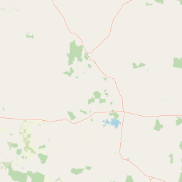
Map view of Junee National Park

Use this park location map to pinpoint Junee National Park in Australia, understand its exact geographic position, and read its mapped placement within the surrounding landscape more clearly.

Pigeon | © OpenStreetMap contributors

Location context for Junee National Park

Queensland
Park atlas

Map adjacent protected landscapes and trace the regional park geography of Central Queensland's Brigalow Belt.

Explore National Parks and Protected Areas Near Junee National Park in Central Queensland
Discover other national parks and protected areas situated near Junee National Park, tracing their mapped geography across central Queensland's Brigalow Belt bioregion. This regional context reveals how different conservation landscapes protect dry sclerophyll forests and woodland habitats against the backdrop of modified surrounding terrain.
National parkQueensland

Taunton National Park: Queensland's Vital National Park and Endangered Species Refuge

Mapped brigalow landscapes and semi-arid woodland terrain.

Taunton National Park in Central Queensland is a protected area of immense conservation value, serving as the last known natural habitat for the endangered bridled nail-tail wallaby. This national park protects representative ecosystems of the Northern Brigalow Belt, featuring distinct brigalow vegetation communities and poplar box woodlands across its cracking clay and texture-contrast soils. Understand the park's geographic setting, its mapped terrain, and the critical role it plays in preserving Australia's unique marsupial populations and diverse flora within the wider regional context.

Area
116 km²
Established
1986
IUCN
II
Relief
Lowland
National parkQueensland

Dipperu National Park: Queensland's Protected Natural Landscape and Geographic Atlas

Mapped boundaries and regional terrain within this Australian national park.

Dipperu National Park represents a significant protected landscape within Queensland, Australia, offering a deep dive into its national park identity and geographic setting. This entry provides detailed atlas-oriented information on its mapped boundaries, natural terrain, and its role in the regional geography of northeastern Australia. Users can explore its distinct landscape characteristics and understand its conservation significance through a structured geographic lens, complementing the broader atlas of protected areas.

Area
111 km²
Established
1969
IUCN
Ia
Relief
Lowland
National parkQueensland

Goodedulla National Park: Queensland National Park Atlas and Geographic Exploration

Discover its mapped protected area and landscape context.

Goodedulla National Park is a designated national park in Queensland, Australia, offering a focused entry point for atlas exploration of protected landscapes. Understand its specific geographic scope, mapped boundaries, and how it fits within the natural and regional context of Queensland. This resource is tailored for users interested in the detailed geography and protected-area data of Australia's natural landscapes.

Area
255 km²
Established
1994
IUCN
II
Relief
Lowland
National parkQueensland

Mount O'Connell National Park: Queensland National Park, Protected Landscape, and Geographic Context

Discover the mapped terrain and regional boundaries within Queensland's natural geography.

Delve into Mount O'Connell National Park, a protected area offering critical insights into Queensland's regional geography and natural landscapes. This national park serves as a vital point for understanding mapped boundaries and the specific protected-area characteristics that define its identity. Users can explore its geographic context within Queensland, providing a solid foundation for atlas-driven discovery and detailed landscape analysis.

Area
7.57 km²
Established
1989
IUCN
II
Relief
Mixed relief
National parkQueensland

Blackdown Tableland National Park: National Park Protected Landscape Discovery

Explore mapped terrain and regional geography in Queensland.

Blackdown Tableland National Park offers a distinct protected landscape for geographic exploration within Queensland, Australia. As a designated national park, its mapped boundaries and surrounding natural terrain provide crucial context for understanding regional geography. This entry serves as a vital point for atlas-based discovery, detailing the park's identity and its contribution to the diverse natural landscapes of northeastern Australia.

Area
320 km²
Established
1991
IUCN
II
Relief
Highland
National parkQueensland

West Hill National Park: Explore Queensland's National Park Geography and Mapped Protected Boundaries

Central Queensland Protected Landscape and Atlas Context

West Hill National Park represents a key protected area within Queensland's natural environment network. As a national park, it offers insights into the region's geography and landscape character, contributing to a structured understanding of protected lands. Explore the mapped boundaries and discover its specific place within the atlas of Australian parks, providing context for its conservation significance in central Queensland.

Area
10.8 km²
Established
1971
IUCN
II
Scope
Terrestrial
National parkQueensland

Peak Range National Park: Mapped Protected Landscape and Regional Geography in Queensland

Explore Queensland's protected areas and natural terrain context.

Peak Range National Park is presented here as a key protected landscape within the diverse geography of Queensland, Australia. Users can explore its specific mapped boundaries and understand its regional setting, contributing to a structured overview of natural areas. This provides essential geographic context and supports deeper atlas-based discovery of Queensland's protected lands and varied terrain.

Area
25 km²
Established
1983
IUCN
II
Relief
Mountain
National parkQueensland

Broad Sound Islands National Park: Queensland National Park Geographic Atlas

Mapped protected boundaries and landscape context in Queensland.

Broad Sound Islands National Park serves as a vital point of reference for exploring Queensland's protected natural areas. This canonical detail entry provides essential insights into the park's geographic positioning, its role as a national park, and its contribution to the regional atlas. Understand its mapped boundaries and unique landscape characteristics as part of a structured geographic discovery.

Area
16 km²
IUCN
II
Relief
Lowland
Climate
Subtropical

Common questions about visiting, size, designation, and location context for Junee National Park

Junee National Park FAQs for park facts, access, geography, and protected area context
Find quick answers about Junee National Park, including protected-area facts, park geography, trail and visitor context, and how the park fits into its surrounding country and regional landscape.
MoriAtlas Explorer

Continue Your Protected Areas Search Across the Global Atlas

Deepen your exploration by continuing the structured search for national parks and protected areas worldwide. Utilize the comprehensive filtering capabilities to compare different conservation landscapes and refine your understanding of global park geography. Discover more about the distribution and characteristics of protected natural areas.

Global natural geography