
Mori Atlas logo
Protected areaKaimanawa Forest Park

Mapping the expansive forested highlands and tectonic landscape character of the central North Island

Kaimanawa Forest Park: Exploring the Remote Backcountry Wilderness and Volcanic Ranges of New Zealand

Kaimanawa Forest Park serves as a significant block of protected native forest within the central North Island, positioned between the shores of Lake Taupo and the prominent volcanic peaks to the west. This backcountry wilderness is defined by the Kaimanawa Ranges, featuring a complex topography of ridges, river valleys, and elevated plateaus that reflect the tectonic influence of the Taupo Volcanic Zone. Understanding this park requires viewing its geography as a transitional forest landscape that preserves large-scale mountain terrain in a geologically active region.

forest parknative foresthigh countrybackcountry wildernessNorth IslandTaupō Volcanic Zone
A stylized digital illustration of a grassy hill landscape with rolling mountains in the distance and a full moon in the sky.

Kaimanawa Forest Park

Protected area

Park overview

Structured park overview, official facts, and landscape profile for Kaimanawa Forest Park

Kaimanawa Forest Park park facts, protected area profile, and essential visitor context

Review the core facts for Kaimanawa Forest Park, including designation, size, terrain, visitor scale, habitats, and operating context in one park-focused overview.

About Kaimanawa Forest Park

Kaimanawa Forest Park is one of the larger forest parks in New Zealand's North Island, occupying a sizeable block of rugged terrain between Lake Taupō to the north and the volcanic mountains further west. The park sits within the Rangitikei District, in the Manawatū-Whanganui Region, and its geography is closely connected with the Taupō Volcanic Zone, a region defined by active and recently active volcanism that has shaped much of the central North Island.

The park takes its name from the Kaimanawa Ranges, a series of forest-clad hills and uplands that form the core of the protected area. While the ranges are not as visually dramatic as the volcanic cones of Tongariro or Ruapehu, they offer a different kind of wilderness experience: expansive, deeply forested, and remote, with limited road access and an atmosphere of genuine backcountry solitude.

Kaimanawa Forest Park was established in 1969 and is administered by the New Zealand Department of Conservation. It plays a complementary role in the broader network of North Island protected areas that ring and traverse the Taupō Volcanic Zone, including the more famous Tongariro National Park to the west and the Pureora and Whanganui forest parks further afield.

For visitors, the park's appeal lies less in single landmark features and more in its overall character: a quiet, forest-dominated high country where the volcanic setting is felt in the surrounding landscape rather than seen in dramatic cone-shaped peaks. It represents the kind of lesser-publicised but geographically significant protected landscape that helps define New Zealand's high-country conservation estate.

Quick facts and research context for Kaimanawa Forest Park

Kaimanawa Forest Park is a conservation-focused protected area in New Zealand's North Island, covering roughly 75,957 hectares of forested high country between Lake Taupō and Mount Tongariro. It lies within the Rangitikei District of the Manawatū-Whanganui Region, inside the broader influence of the Taupō Volcanic Zone. The park was formally established in 1969 and is administered by the New Zealand Department of Conservation.

Protection and recognition

Terrestrial protected area classification and management records

Kaimanawa Forest Park Protection Status and Conservation Recognition

Kaimanawa Forest Park holds a documented terrestrial conservation status within the regional protected area network. Official records compile management scope and designation history without asserting external international recognitions.

Protection details

Protection scope
Terrestrial
Transboundary protection
No
Park context

Deeper park guide and search-rich context for Kaimanawa Forest Park

Kaimanawa Forest Park history, landscape, wildlife, and travel context

Explore Kaimanawa Forest Park through its history, landscape character, ecosystems, wildlife, conservation priorities, cultural context, and seasonal travel timing in a structured park guide built for atlas discovery and search intent.

Why Kaimanawa Forest Park stands out

Kaimanawa Forest Park is best known for the remote and rugged Kaimanawa Ranges, an extensive block of forested backcountry that occupies the plateau-like high ground between Lake Taupō and the more dramatic volcanic peaks further west. The park's identity is tied to its scale, its location within the Taupō Volcanic Zone, and the sense of isolation it offers from the busier North Island tourist circuits. Its character is also defined by the deep forest cover across the ranges, the influence of the volcanic landscape that surrounds it, and its position as one of the larger conservation forest parks in the central North Island. Together these qualities give the park a profile centred on backcountry wilderness rather than dramatic single-landmark scenery.
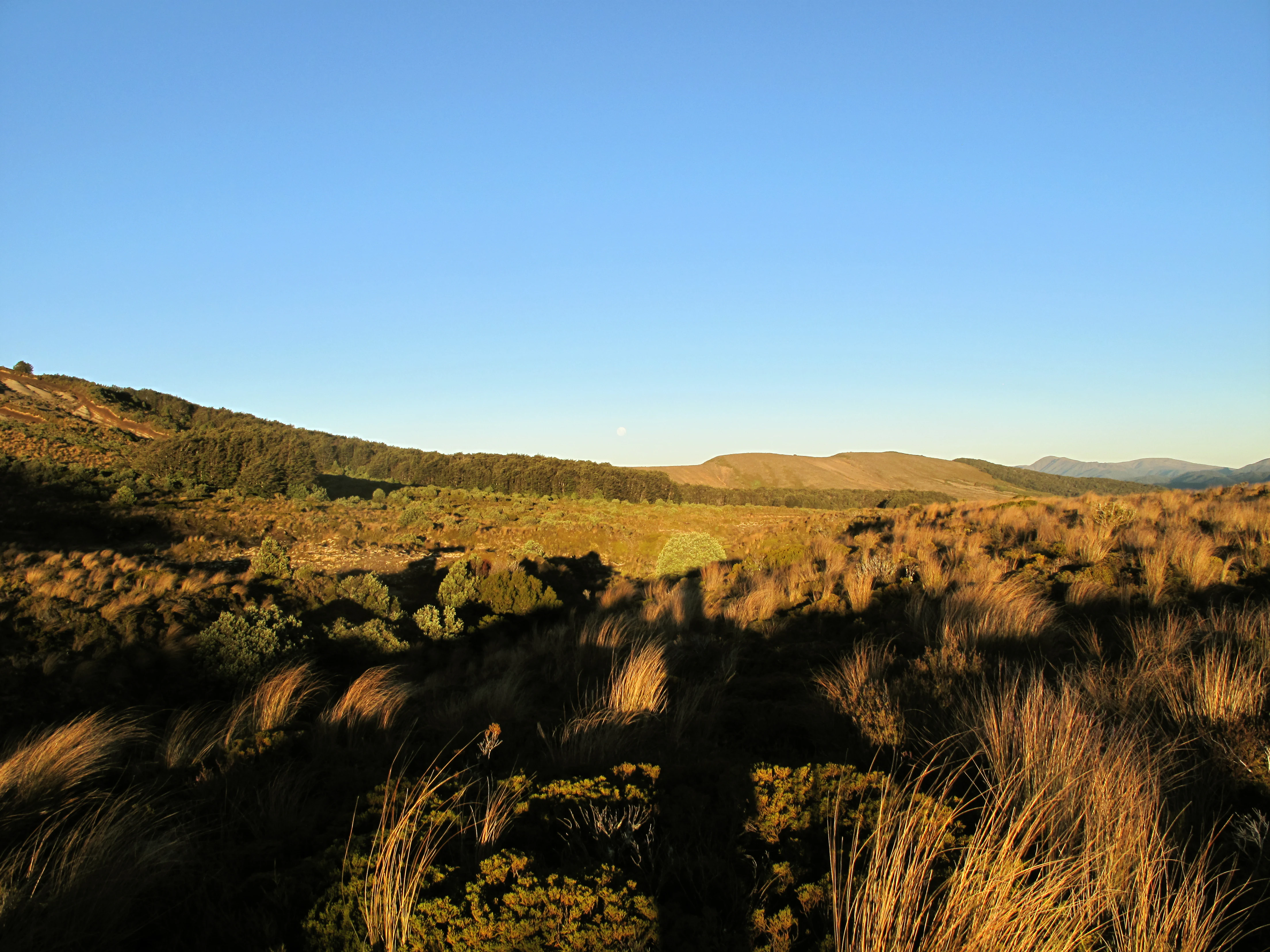
A wide, golden-hour view of rolling, sun-drenched hills covered in native tussock grass with a clear blue sky above and a prominent human shadow stretching across the foreground.
Sunset light casting long shadows over the tussock grasslands and rolling hills of the Kaimanawa Ranges.

Kaimanawa Forest Park history and protected-area timeline

Kaimanawa Forest Park was formally established in 1969 as a protected forest area in New Zealand's North Island. Its creation occurred during a period when New Zealand was actively expanding its network of forest parks and conservation reserves to safeguard representative examples of the country's native forests and high-country landscapes.

The park's location, between Lake Taupō and the Tongariro volcanic massif, placed it within an area where forestry, hunting, and conservation interests intersected. Designating the area as a forest park provided a framework for long-term protection of its native vegetation and backcountry character, while still allowing some forms of public use under the management of the Department of Conservation.

Since its establishment, the park has remained part of New Zealand's national conservation estate, administered through the same department that manages the country's other public conservation lands. Its history is less about dramatic events and more about ongoing administrative and ecological stewardship of a sizeable central North Island forest landscape.

Kaimanawa Forest Park landscape and geographic character

The landscape of Kaimanawa Forest Park is shaped by the Kaimanawa Ranges, a broad, heavily forested highland area that dominates the central North Island east of Mount Tongariro. The terrain is characterised by rolling hills, deeply dissected ridges, river valleys, and elevated plateaus typical of backcountry New Zealand. The elevations vary across the park, creating a textured topography of forested slopes and intervening gullies.

Although the park lies within the broader Taupō Volcanic Zone and is influenced by the same geological forces that built the nearby volcanic peaks, the ranges themselves do not display the dramatic cone-shaped profiles of Tongariro or Ruapehu. Instead, the volcanic influence is felt in the underlying geology, in soil patterns, and in the regional landscape setting, rather than in towering summits within the park.

To the north, Lake Taupō forms a major landscape boundary, while the dramatic profiles of the central North Island volcanoes lie to the west. Between these features stretches the quieter forested expanse of the Kaimanawa Ranges, giving the park a transitional landscape character between true high-alpine volcanic terrain and lower-elevation New Zealand forest environments.

Kaimanawa Forest Park ecosystems, habitats, and plant life

The natural character of Kaimanawa Forest Park is defined by extensive native forest cover across a sizeable high-country landscape. The park's ecological identity is closely tied to its position between the lacustrine and volcanic environments of the central North Island, with native forest communities forming the dominant vegetation pattern across the ranges.

The Taupō Volcanic Zone setting influences the park's ecology in subtle but meaningful ways, contributing to soil composition, hydrology, and vegetation patterns that differ from forests further away from the volcanic belt. The combination of elevation changes, rainfall patterns, and varied topography creates a mosaic of forest habitats across the ranges, supporting the broader biodiversity of the central North Island.

Because the park is remote and largely undeveloped, large portions retain a comparatively unmodified natural character. This continuity of forest cover, combined with the park's size and its position within a national-scale conservation network, makes it an ecologically significant component of North Island native forest protection.

Kaimanawa Forest Park wildlife and species highlights

Wildlife in Kaimanawa Forest Park is shaped by the park's extensive native forest cover and its location within the central North Island. The habitat supports the forest-based fauna typical of New Zealand's high-country beech and podocarp environments, including native birdlife that relies on continuous tracts of mature forest.

The ranges are also well known in New Zealand wildlife management circles as a site associated with deer control history, a legacy that continues to shape conservation management across the broader Kaimanawa landscape. This context, alongside native biodiversity values, gives the park a dual wildlife significance: as habitat for indigenous species and as an area where introduced species management has been an ongoing conservation focus.

Specific wildlife details are not strongly documented for the park itself, but its forest cover, elevation variation, and location within a wider conservation corridor mean it contributes meaningfully to the broader fauna of the central North Island.

Kaimanawa Forest Park conservation status and protection priorities

Kaimanawa Forest Park contributes significantly to New Zealand's conservation framework as a sizeable protected forest area in the central North Island. Its roughly 75,957 hectares of backcountry forest help maintain a continuous block of native vegetation in a region where the surrounding land has been heavily modified by agriculture, forestry, and development.

By occupying the high ground between Lake Taupō and the Tongariro volcanic complex, the park forms an important ecological buffer within the Taupō Volcanic Zone. Its protection supports watershed functions, native habitat retention, and landscape connectivity that benefits both endemic species and broader North Island ecological processes.

Conservation management of the park is carried out by the Department of Conservation, which oversees the same network of public conservation lands that includes the country's national parks, forest parks, and ecological reserves. The park's enduring protection reflects its role as a representative example of New Zealand's high-country forest environments, rather than a site of single iconic species or landmarks.

Kaimanawa Forest Park cultural meaning and human context

Kaimanawa Forest Park sits within a region of the central North Island where Māori have long historical connections to the land, water, and forest resources surrounding Lake Taupō and the volcanic interior. The wider Taupō Volcanic Zone carries deep cultural significance for iwi and hapū of the region, with traditional relationships to lands, waterways, and mountain environments extending across generations.

While the park itself is primarily recognised for its natural values and conservation role, its location within this broader cultural landscape means that any engagement with the area draws on a wider regional identity shaped by tangata whenua (people of the land) and their long-standing connections to the central North Island environment.

Top sights and standout views in Kaimanawa Forest Park

Kaimanawa Forest Park's strongest features include its sheer scale as one of the larger North Island forest parks, its position within the Taupō Volcanic Zone, and the unbroken character of its forested ranges. Set between Lake Taupō and Mount Tongariro, it complements the more famous volcanic landscapes of the central North Island with a quieter, wilderness-focused experience.

The park's highlights also extend to its conservation significance as an extensive block of protected native forest in a heavily modified regional landscape. For visitors and researchers alike, its appeal lies in the combination of remote backcountry atmosphere, volcanic-zone setting, and central North Island geographic context.

Best time to visit Kaimanawa Forest Park

Kaimanawa Forest Park is best approached in the warmer and drier months of the New Zealand summer, generally from late spring through early autumn, when forest tracks are more accessible and weather conditions in the central North Island high country are most stable. Summer visits also allow longer daylight hours and more comfortable conditions for the kind of backcountry exploration the park invites.

Winter can bring colder temperatures, frost, and occasional snow to higher elevations in the ranges, increasing the remote and wild character of the park but also making access more challenging. Visitors in winter should be prepared for shorter days, more variable conditions, and the more limited recreational opportunities that come with wetter and cooler central North Island weather.
Monthly climate preview

Long-term representative point measurements of monthly temperature and precipitation rhythms

Kaimanawa Forest Park Climate Normals and Annual Weather by Month

Kaimanawa Forest Park records long-term average monthly temperatures ranging from 4.9 degrees Celsius in midwinter to over 16 degrees Celsius in summer, alongside consistent year-round precipitation. Reviewing the complete twelve-month profile provides deep baseline metrics for analyzing regional environmental patterns.
Annual mean10 °C
5 °C16 °C
Jan15°
Feb16°
Mar14°
Apr11°
May
Jun
Jul
Aug
Sep
Oct
Nov11°
Dec13°
Warmest month
February

16 °C

Coolest month
July

4.9 °C

Wettest month
June

3.9 mm/day

Driest month
March

2.4 mm/day

Park location guide

Geography guide, regional context, and park location map for Kaimanawa Forest Park

Kaimanawa Forest Park park geography, regions, and map view in New Zealand

Understand where Kaimanawa Forest Park sits in New Zealand through a broader geographic reading of the surrounding landscape, nearby location context, and its mapped position within the national park landscape.

How Kaimanawa Forest Park fits into New Zealand

New Zealand is an island nation in the southwestern Pacific Ocean comprising two main islands and numerous smaller islands. Located east of Australia across the Tasman Sea, it features varied topography with the Southern Alps running along the South Island and volcanic terrain on the North Island. The country was settled by Maori people between 1280 and 1350, followed by European exploration beginning in 1642, and became a Dominion in 1907 before gaining full independence in 1947.

Wider geography shaping Kaimanawa Forest Park in New Zealand

New Zealand lies in the southwestern Pacific Ocean, east of Australia across the Tasman Sea. The country consists of two main islands, the North Island and South Island, plus over 600 smaller islands. The North Island features volcanic plateaus and hills while the South Island is dominated by the Southern Alps mountain range. The country has a long coastline and is surrounded by the Pacific Ocean.

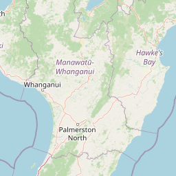
Map view of Kaimanawa Forest Park

Use this park location map to pinpoint Kaimanawa Forest Park in New Zealand, understand its exact geographic position, and read its mapped placement within the surrounding landscape more clearly.

Pigeon | © OpenStreetMap contributors

Location context for Kaimanawa Forest Park

Manawatu-Whanganui Region
Recorded earthquake history

Examine the Recorded Earthquake History of Kaimanawa Forest Park

Discover the documented seismic record surrounding the Kaimanawa Ranges. This catalogue, integrated into the MoriAtlas platform, offers clear visibility into historical earthquake events, magnitudes, and epicentre locations associated with this significant protected landscape.

Kaimanawa Forest Park Earthquake History

Catalogued events

366 events

Strongest magnitude

Magnitude 6.2

Most recent event

Aug 17, 2026

This history includes earthquakes recorded inside the park or within 50 km of its borders

Explore photographic views of remote mountain ranges and protected forest terrain

Kaimanawa Forest Park Photos and Landscape Scenery Visual Guide

Visual records capture the rugged topography and unbroken native forest cover defining the Kaimanawa Ranges. Photographic documentation reveals the backcountry character, valley networks, and volcanic zone setting characterizing the protected landscape.

A wide, golden-hour view of rolling, sun-drenched hills covered in native tussock grass with a clear blue sky above and a prominent human shadow stretching across the foreground.

Park atlas

Compare adjacent volcanic zone reserves, mountain ranges, and regional forest habitats.

Explore Parks Near Kaimanawa Forest Park and Surrounding Protected Areas

Browse protected areas near Kaimanawa Forest Park to examine broader regional terrain across the central North Island. Comparing these nearby conservation landscapes reveals the varied topography connecting volcanic high country and remote native forest reserves.
A watercolor painting showing soft, rolling green mountains and forest lines under a bright, light-filled sky.
Protected landscapeHawke's Bay
Park boundaries overlap#1 closest

East

Kaweka Forest Park: Protected Landscape and Mountain Geography in Hawke's Bay

High-altitude alpine terrain and forest reserve mapping

Kaweka Forest Park represents a massive block of protected country in the central North Island, defined by the Kaweka Range and its prominent 1,724-metre summit. The landscape shifts from managed pine plantations to rugged, dissected mountain ridges, offering a unique study in New Zealand's interior geography, native ecological restoration, and geothermal features like the Mangatutu Hot Springs.

Area
594.26 km²
Established
1972
Relief
Mountain
Climate
Temperate
National parkNew Zealand
Park boundaries overlap#2 closest

West

Tongariro National Park: New Zealand's Premier Volcanic National Park Atlas

Explore mapped terrain, active volcanoes, and unique dual World Heritage values.

Tongariro National Park, situated in New Zealand's North Island, is a globally significant protected area celebrated for its dramatic volcanic landscapes and profound cultural heritage. As the nation's oldest national park, it features three active volcanoes: Mount Ruapehu, Mount Ngauruhoe, and Mount Tongariro, set within a diverse terrain that includes forests, alpine zones, and the Rangipo Desert. Its dual World Heritage status underscores its importance for both natural attributes and its sacred cultural landscape, offering rich opportunities for geographic and atlas exploration.

Area
795.96 km²
Established
1887
IUCN
II
Relief
Mountain
Protected landscapeWaikato
28 km away#3 closest

North

Pureora Forest Park: Ancient Rainforests and Protected Mountain Landscapes in Waikato

Regional geography and mapped native forest boundaries

Pureora Forest Park represents a significant protected area in the central North Island of New Zealand, defined by its towering podocarp giants and complex volcanic terrain. The park serves as a prime example of an intact rainforest ecosystem, featuring dense broadleaf canopies, deep river valleys, and significant remnants of ancient forest history. Its geography, shaped by both geological upheaval and centuries of growth, provides an essential record of the natural heritage preserved across the Waikato and Manawatu-Whanganui regions.

Area
759.57 km²
Established
1978
Relief
Mountain
Water
Major water bodies
National parkNew Zealand
53 km away#4 closest

Southwest

Whanganui National Park: Protected Wilderness Landscape and Geographic Context

Explore the mapped boundaries and natural terrain of this national park.

Whanganui National Park offers a unique blend of natural wilderness and significant cultural history, centered on the Whanganui River valley. This protected area safeguards one of New Zealand's most extensive lowland forest ecosystems, providing vital habitat and showcasing a landscape deeply intertwined with Māori traditions and historical settlement. Understanding its geographical setting and mapped protected boundaries reveals its importance as a distinct national park.

Area
742 km²
Established
1986
IUCN
II
Relief
Lowland
Watercolor painting of a green landscape featuring rolling hills, forested slopes, and a body of water in the foreground against a light, misty background.
Marine protected areaNew Plymouth District
112 km away#5 closest

West

Parininihi Marine Reserve: A Detailed Atlas of New Zealand's Coastal Marine Protected Area

Mapping the ecological sanctuary and reef geography in the New Plymouth District.

Gain insights into the geography of Parininihi Marine Reserve, a protected marine environment north-east of New Plymouth. This record outlines the reserve's structural features, from the iconic White Cliffs coastline to the complex underwater canyons and pinnacles of the Pariokariwa Reef. Learn about the seafloor terrain and the ecological distribution of invertebrate colonies and fish populations that define this crucial New Zealand marine reserve.

Area
18 km²
Established
2006
Relief
Lowland
Climate
Temperate
National parkNew Zealand
134 km away#6 closest

West

Egmont National Park: New Zealand's Distinctive Volcanic National Park

Explore the mapped volcanic terrain and protected landscape of Mount Taranaki.

Egmont National Park represents a significant protected area within New Zealand's North Island, dominated by the iconic stratovolcano, Mount Taranaki. This national park is celebrated for its distinct circular protected boundary, a unique feature against the surrounding pastoral farmlands, and its dramatic volcanic landscape. Visitors can explore a range of natural habitats from dense temperate rainforests to alpine environments, all mapped within this significant conservation landmark.

Area
341.7 km²
Established
1900
IUCN
II
Visitors
400K annual
Watercolor painting of Moutohora Island featuring green volcanic hills, coastal vegetation, and a soft pink water surface.
Wildlife reserveBay of Plenty
About 134 km away#7 closest

Northeast

Moutohora Island Wildlife Reserve: Volcanic Geography and Coastal Protected Area

Exploration of a restored island sanctuary in the Bay of Plenty

Moutohora Island is a protected wildlife refuge defined by its volcanic heritage and active geothermal features. The landscape comprises twin peaks, valleys, and coastal cliffs that provide a secure habitat for breeding seabirds and native forest restoration efforts. This island offers a distinct look at maritime conservation and geological remnants within the broader Bay of Plenty regional geography.

Area
1.43 km²
Established
1965
Relief
Upland
Access
Highly restricted
A wide, panoramic watercolor illustration showing layers of green rolling hills in the foreground, a line of green trees in the mid-ground, and soft purple and pink mountains in the background against a pale yellow sky.
Protected areaNew Zealand
About 135 km away#8 closest

Northwest

Pirongia Forest Park: Mapped Geography and Protected Landscapes in the Waikato Region

Volcanic summits and native podocarp forest boundaries

Gain a deeper understanding of Pirongia Forest Park through its complex volcanic geology and dense native vegetation. This resource outlines the park's fragmented ridges, limestone stream systems, and its role as a biogeographic bridge within the Waikato landscape of New Zealand.

Area
167.7 km²
Established
1971
Relief
Mountain
Climate
Temperate

Common questions about visiting, size, designation, and location context for Kaimanawa Forest Park

Kaimanawa Forest Park FAQs for park facts, access, geography, and protected area context

Find quick answers about Kaimanawa Forest Park, including protected-area facts, park geography, trail and visitor context, and how the park fits into its surrounding country and regional landscape.
MoriAtlas Explorer

Continue Your Protected Areas Search Across the Global Atlas

Deepen your exploration by continuing the structured search for national parks and protected areas worldwide. Utilize the comprehensive filtering capabilities to compare different conservation landscapes and refine your understanding of global park geography. Discover more about the distribution and characteristics of protected natural areas.

Global natural geography