Mori Atlas logo
Nature reserveKaldenkirchener Grenzwald

Examining the intersection of sandy forest rewilding, rare heath moor remnants, and exotic arboretum heritage

Kaldenkirchener Grenzwald Nature Reserve: A Mapped Study of Lower Rhine Border Landscapes

The Kaldenkirchener Grenzwald serves as a vital protected area on the Lower Rhine, tracing the Maas valley escarpment along the border between Germany and the Netherlands. This forest landscape presents a distinct combination of nutrient-poor sandy terrain, remnants of ancient heath moors like the Langes Venn, and the Sequoiafarm Kaldenkirchen arboretum. Through mapped boundaries and regional analysis, observers can trace the evolution of this protected ecosystem from post-war reforestation efforts to its status as a critical sanctuary for moorland flora and fauna.

border forestLower Rhinenature protection arealandscape protection areaheath moorraised bog

Kaldenkirchener Grenzwald

Nature reserve

Park overview

Structured park overview, official facts, and landscape profile for Kaldenkirchener Grenzwald

Kaldenkirchener Grenzwald park facts, protected area profile, and essential visitor context

Review the core facts for Kaldenkirchener Grenzwald, including designation, size, terrain, visitor scale, habitats, and operating context in one park-focused overview.

About Kaldenkirchener Grenzwald

The Kaldenkirchener Grenzwald occupies a distinctive position on the left bank of the Lower Rhine, sitting at the seam between Germany and the Netherlands in the western part of the municipality of Nettetal. Its western edge falls away toward the Maas in a steep slope locally known as Die Schlucht, while the rest of the protected area spreads inland across gently undulating sandy terrain. This combination of border geography, Maas valley topography, and sandy soils gives the Grenzwald a different character from the broad agricultural landscapes typical of the surrounding Lower Rhine.

The protection area is a hybrid designation: it is simultaneously a Landschaftsschutzgebiet, a landscape protection area focused on the broader scenery and land use, and a Naturschutzgebiet, a stricter nature protection area that locks in targeted ecological safeguards. It also forms part of the Maas-Schwalm-Nette Nature Park, tying it into a wider regional network of natural and cultural landscapes that span both sides of the border.

Ecologically, the forest is built on soils that are described as predominantly sandy, low in nutrients, and interrupted by small moor and swamp patches. These conditions limited what could grow here historically and shaped both the original woodland and the choices made during post-war reforestation. Today the forest is valued for its developed broadleaf and conifer mixture, its surviving heath bog relics, and the presence of the Sequoiafarm Kaldenkirchen arboretum with its stands of giant sequoia and coast redwood, making the Grenzwald a place where different conservation aims, recreational use, and forestry heritage come together.

Quick facts and research context for Kaldenkirchener Grenzwald

The Grenzwald lies on the left Lower Rhine in the municipality of Nettetal, with the Maas escarpment and the Dutch border marking its western edge. It is designated both as a landscape protection area and a nature protection area, and it belongs to the Maas-Schwalm-Nette Nature Park.

The soils are predominantly sandy and nutrient-poor, with some clay inclusions and a few small moor and swamp zones; these conditions originally favored pine forest and continue to shape the vegetation today. The forest was completely burned after being cut for war reparations in 1947, was gradually replanted from 1949 onward, and now hosts Sequoiafarm Kaldenkirchen, a unique arboretum of giant sequoias and coast redwoods alongside native broadleaves and conifers.

Protection and recognition

Terrestrial protected area metrics and formal designation records

Kaldenkirchener Grenzwald Protection Status and Conservation Data

Terrestrial conservation frameworks define the protected area designation and land management scope governing Kaldenkirchener Grenzwald. Official records compile documented protection status details and international recognition parameters for regional analysis.

Protection details

Protection scope
Terrestrial
Transboundary protection
No
Park context

Deeper park guide and search-rich context for Kaldenkirchener Grenzwald

Kaldenkirchener Grenzwald history, landscape, wildlife, and travel context

Explore Kaldenkirchener Grenzwald through its history, landscape character, ecosystems, wildlife, conservation priorities, cultural context, and seasonal travel timing in a structured park guide built for atlas discovery and search intent.

Why Kaldenkirchener Grenzwald stands out

The Kaldenkirchener Grenzwald is known above all for its combination of a largely human-rebuilt forest and a remarkable surviving cluster of raised bogs on the Lower Rhine. The Langes Venn, Galgenvenn, Kempkes Venn, and Sonsbeck are regarded as the last heath moors of their kind in the Lower Rhine region, and act as refuges for uncommon plants such as cottongrass, grey bell heather, sundew, and white beak-sedge. Equally distinctive is the Sequoiafarm Kaldenkirchen, an experimental arboretum set within the protection area that contains mature stands of giant sequoia and coast redwood. Together with its 1.5 kilometer chestnut avenue planted in multiple varieties, the site gives the Grenzwald an unusual character that bridges native European woodland restoration and exotic forestry experimentation in a single landscape.
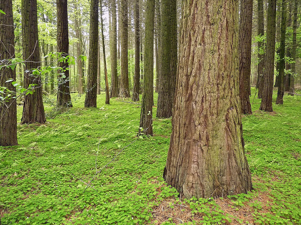
Giant sequoia at Sequoiafarm
60 year old giant sequoia trees at the Sequoiafarm Kaldenkirchen test site

Kaldenkirchener Grenzwald history and protected-area timeline

The history of the Kaldenkirchener Grenzwald is inseparably linked to the political upheavals of the twentieth century. Long before the modern designation, the sandy soils of the area had supported only modest pine forest, and the clay deposits had been worked by a local roof-tile industry that has since disappeared. After 1800, when regulated forestry was introduced in response to widespread timber shortages, the soil conditions effectively dictated that only the undemanding Scots pine could be widely planted.

The decisive rupture came after the Second World War. The forest was declared a restricted zone, and ownership of the standing timber was assigned to the Netherlands as part of postwar reparations. Stripped stands of dry branches and abandoned crowns covered the ground through the hot summer of 1947 and caught fire, burning the entire forest to ash and exposing pure sand. Without tree cover or humus, the open sand was lifted by the wind in unusual sandstorms that crossed fields and neighboring villages, accelerating erosion across the bare landscape.

Reforestation had to overcome formidable obstacles. Not only was the soil exhausted, but the post-war economy offered little funding, and the forest was fragmented across roughly 5,000 small parcels, some as small as 0.1 hectares, whose owners had little appetite for replanting. Compensation from an earlier Belgian timber cut in 1919 had already been wiped out by inflation, and Dutch reparations payments were again allowed to depreciate during the currency reform. Inspired by Ernst J. Martin, foresters nonetheless managed to form the Waldwirtschaftsgemeinschaft Kaldenkirchen on 14 November 1949, bringing nearly all forest farmers together and, after a land consolidation procedure, securing substantial means for replanting.

The new forest grew in deliberate stages. Windbreak alleys were planted first, with tall standard trees set in fresh humus and individually staked and fenced against browsing wildlife. In 1951, 650,000 pines were planted, later joined by red oaks and countless bird-protection shrubs to avoid monoculture. May beetle swarms and pine blight threatened the young stands, prompting interventions such as nest boxes for birds and bats, the deliberate introduction of red wood ants from the Eifel, expanded firebreak lanes, and dedicated extinguishing ponds. Experimental forestry at what would become Sequoiafarm Kaldenkirchen tested additional species, and a 1.5 kilometer chestnut avenue in multiple varieties became a local landmark. The Deutsche Waldjugend Viersen has tended a sponsored section of the forest for decades and, among other projects, carried out a bat reintroduction program.

Kaldenkirchener Grenzwald landscape and geographic character

The Grenzwald sits on a gently uneven sandy plain on the left Lower Rhine, with the defining feature of its landscape being the western Maas escarpment where, in local speech, the slope to the Maas is called Die Schlucht. That slope also marks the German-Dutch border and gives the protected area its name as a Grenzwald, literally a forest of the border. The forest thus reads as an inland sandy woodland with a sudden scenic break at its western edge.

Inside the forest, the terrain is shaped mostly by soil rather than relief. Nutrient-poor sand dominates, with clay patches and a scattering of small moor and swamp zones that interrupt the dry upland forest with wetter, more acidic hollows. Heath bog remnants such as Langes Venn, Galgenvenn, Kempkes Venn, and Sonsbeck are the most striking landscape features, being the last examples of their type on the Lower Rhine. These former peat-cutting and flax-retting hollows have matured into protected, oligotrophic micro-landscapes with their own plant communities.

A more planted layer of landscape runs through the Sequoiafarm Kaldenkirchen area, where experimental forestry plots, the chestnut avenue, and the maturing stands of giant sequoia and coast redwood sit beside the native woodland. A geo-hydrological water garden near the arboretum adds a designed element that also demonstrates how groundwater moves through this sandy terrain.
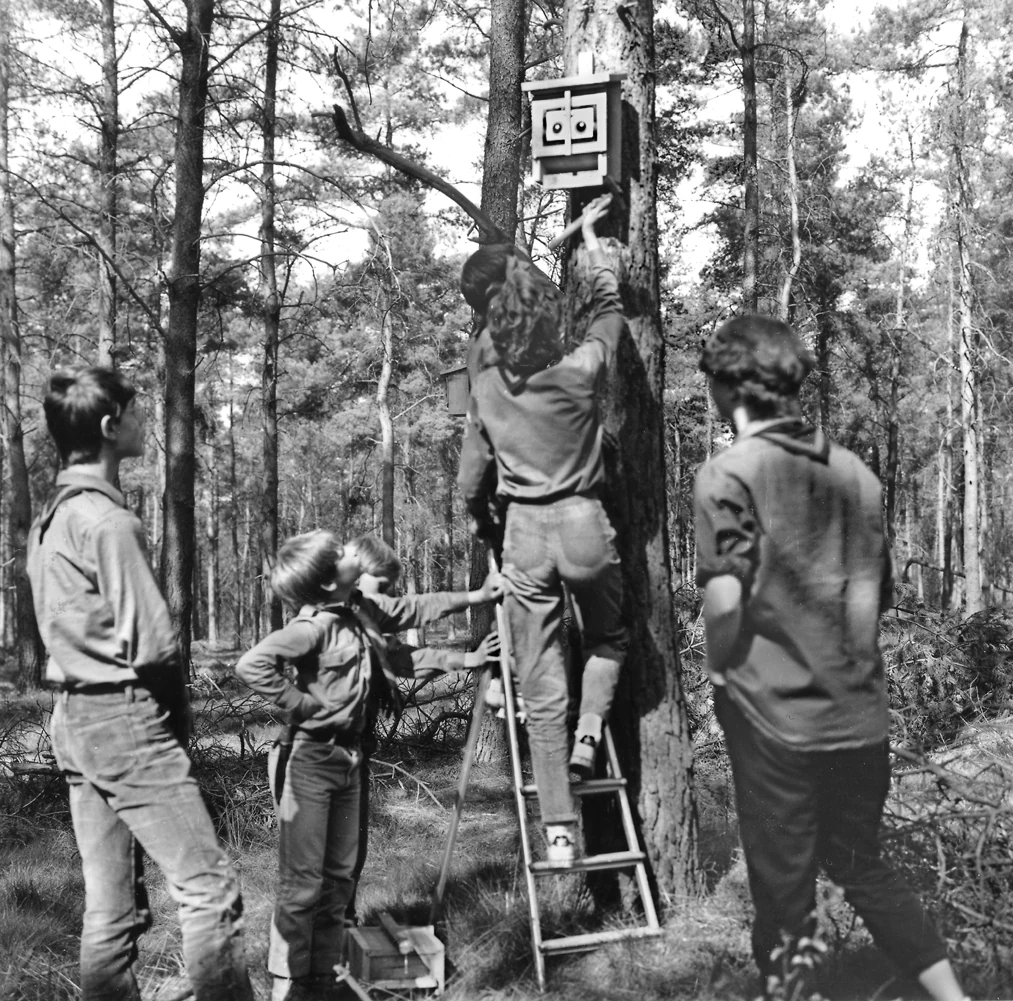
Bat nesting box
Members of the forest youth group installing a bat reintroduction box in the Kaldenkirchener Grenzwald

Kaldenkirchener Grenzwald ecosystems, habitats, and plant life

From an ecological perspective, the Grenzwald is best understood as a carefully reconstructed pine and mixed forest sitting on acidic, sandy substrate, interrupted by small but exceptionally valuable peatland pockets. The original forest was dominated by Scots pine because the soils offered little else; the post-war replanting inherited that baseline but enriched it with red oak, native broadleaves, and the experimental exotic species of the Sequoiafarm.

The most ecologically distinctive element is the set of protected heath moors in the southern part of the forest. The Langes Venn, Galgenvenn, Kempkes Venn, and Sonsbeck function as nutrient-poor refugia within an otherwise sandy and relatively dry woodland matrix. Their flora reflects classic bog conditions, with cottongrass, grey bell heather, sundew, and white beak-sedge among the species documented here. These bogs arose partly from earlier small-scale peat cutting and from pits once used to ret flax in the nineteenth century, so the ecological character of today is partly the result of past land use gradually turning into conservation habitat.

Forest management in the area has deliberately moved away from monoculture. The replanting program introduced shrub layers, retained broadleaf diversity, and expanded hedgerow and shelter planting to support wildlife. The heath bog zones are maintained through landscape planning instruments, which means their character is actively shaped by ongoing intervention rather than left entirely to natural processes.
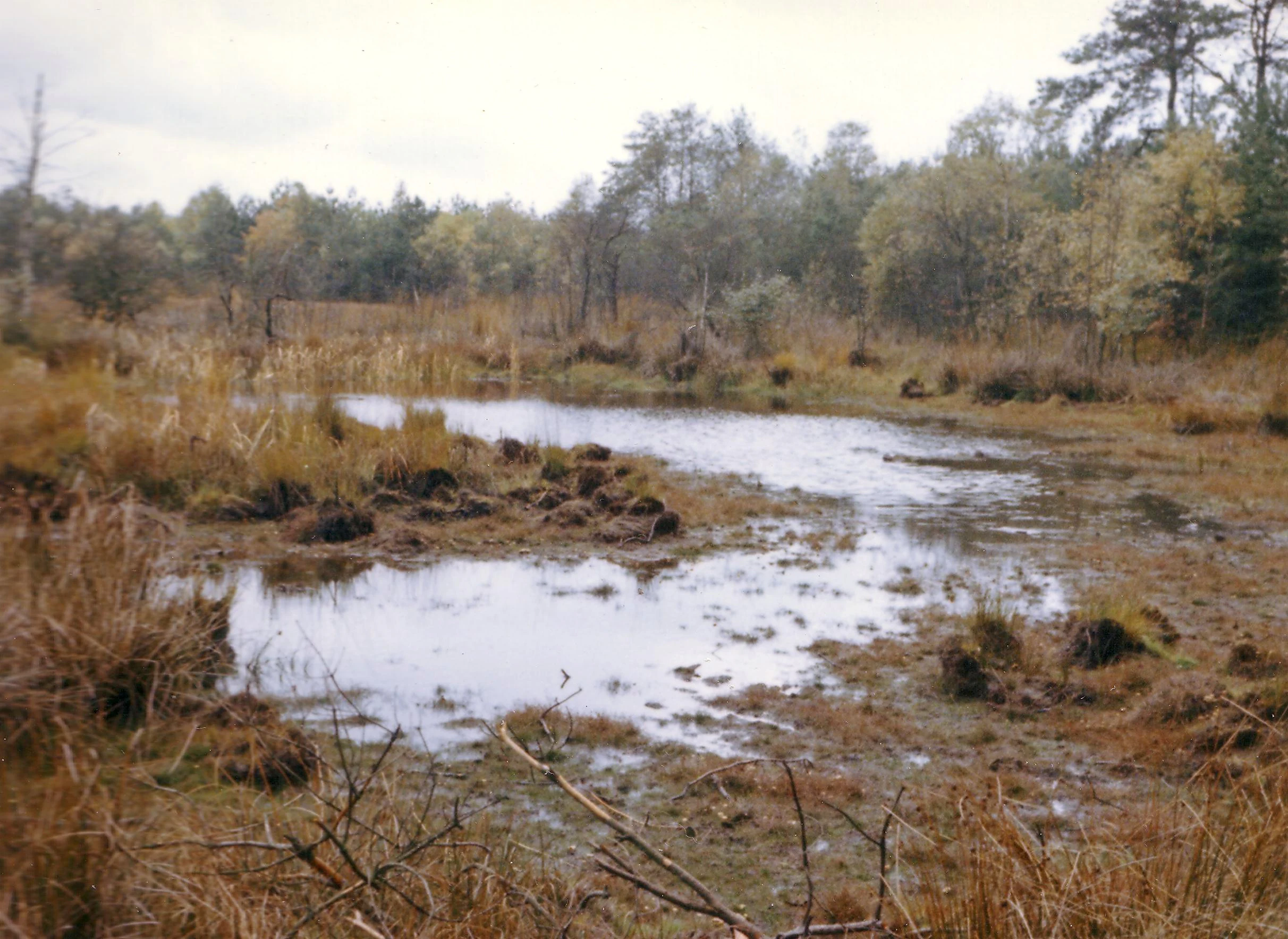
Kempkes Venn Raised Bog
The Kempkes Venn raised bog located in the Kaldenkirchener Grenzwald near Nettetal.

Kaldenkirchener Grenzwald wildlife and species highlights

Wildlife in the Kaldenkirchener Grenzwald is shaped by the mix of dry sandy woodland, wet bog hollows, and the border-edge forests along the Maas. While the forest itself is relatively young in its current form, its structure of pine, oak, broadleaf scrub, and bog-margin vegetation provides niches for a recognizable range of species.

Bats have been a focus of active conservation, with the Deutsche Waldjugend Viersen running a reintroduction program in a sponsored section of the forest, and bat boxes installed throughout the woodland. The bog margins and Venns are particularly important for invertebrates, hosting rare dragonfly species and occasional visitors such as the white-spotted moth, Weißfleck-Widderchen, a notable butterfly that appears only sporadically. The protected heath moors also support one of the largest populations of moor frogs in North Rhine-Westphalia, making the Grenzwald regionally important for this single species.

The bird community includes both typical forest birds associated with the pine and mixed stands, and bog-loving species tied to the wetter Venns. During reforestation, nest boxes for birds and bats were installed on a large scale, and red wood ants were deliberately introduced from the Eifel to help establish a more balanced woodland food web. Together, these measures have helped the rebuilt forest rapidly accumulate a recognizable faunal community despite its post-war origins.
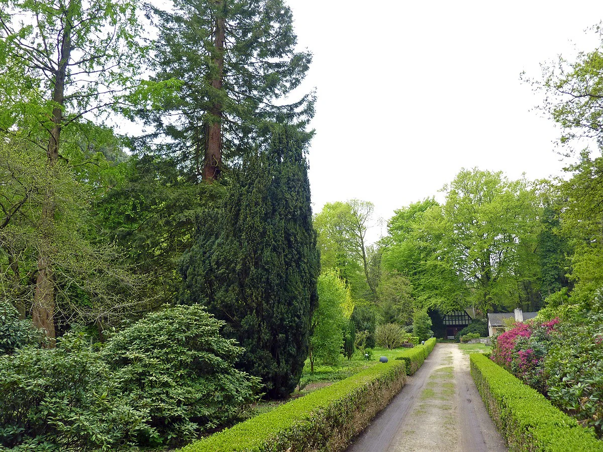
Sequoiafarm Entrance
Entrance area to the Sequoiafarm Kaldenkirchen

Kaldenkirchener Grenzwald conservation status and protection priorities

Conservation significance in the Grenzwald rests on two intertwined facts: the protection status itself, and the rarity of what is being protected. The area holds both a landscape protection designation and a stricter nature protection designation, and sits within the Maas-Schwalm-Nette Nature Park, placing it within a regional conservation framework that crosses the Dutch border. This combination of designations offers both broad landscape-level safeguards and targeted protection for the most sensitive habitats.

The heath moors of Langes Venn, Galgenvenn, Kempkes Venn, and Sonsbeck are conservatively the most important element. They are described as the last heath bogs of their kind on the Lower Rhine, which gives their protection value well beyond the local scale. Their management is actively supported through landscape planning measures, ensuring that the open, nutrient-poor character required by their specialist flora and fauna is maintained rather than lost to scrub encroachment.

Forest conservation here is also a story of restoration rather than just preservation. The deliberate transition from a planned pine monoculture to a more diverse mix of pines, red oaks, native broadleaves, and shelter shrubs reflects an effort to rebuild ecological balance. Experimental work at Sequoiafarm Kaldenkirchen, plus ongoing programs such as the bat reintroduction, firebreak maintenance, and red wood ant introductions, show that the area is treated as a living laboratory for woodland recovery as much as a passive reserve.

Kaldenkirchener Grenzwald cultural meaning and human context

The Kaldenkirchener Grenzwald carries a strong local cultural identity shaped by the borderland setting, the trauma of wartime timber cuts, and the unusual arboretum within it. The very name Grenzwald reflects its position along the German-Dutch boundary, and stories of forced logging, the 1947 fire, and the sandstorms that followed are part of how local communities remember the landscape.

The founding of the Waldwirtschaftsgemeinschaft Kaldenkirchen in 1949 is treated locally as a turning point: nearly all forest owners banded together to replant what had been a wasteland, and figures like Ernst J. Martin are remembered as catalysts of that effort. Today the Grenzwald hosts community engagement through the Deutsche Waldjugend Viersen, regular guided nature tours, and a network of riding and walking paths that tie the protection area into everyday local life. The Sequoiafarm and its chestnut avenue add a layer of cultural curiosity, drawing visitors interested in unusual tree species and the history of experimental forestry on German soil.

Top sights and standout views in Kaldenkirchener Grenzwald

The Grenzwald combines the rare surviving heath bogs of the Lower Rhine, a roughly 1.5 kilometer chestnut avenue with multiple fruit varieties, and the working arboretum of Sequoiafarm Kaldenkirchen with its mature giant sequoia and coast redwood stands. It is home to one of the largest moor frog populations in North Rhine-Westphalia, and the Premium hiking trail Galgenvenn, voted Germany's second most beautiful hiking trail in 2016, threads through the heart of the protection area.

Best time to visit Kaldenkirchener Grenzwald

Spring and early summer are typically the most rewarding seasons, when the bog margins come alive with cottongrass, sundew, and other heath plants, and when dragonflies and amphibians such as the moor frog are most active around the Venns. Late spring mornings also tend to be the best period for guided nature tours and for experiencing the chestnut avenue at the height of its leafy display.

Late summer and early autumn remain attractive for walking and horse riding along the marked trails, including the Galgenvenn premium path, when the Sequoiafarm stands and the mixed broadleaf canopy present cooler, more sheltered conditions. Midsummer can be hot and dry on the sandy soils, which is also historically when the area was most fire-prone, while winter visits tend to be quieter and centered on the stark shapes of the sequoia stands and the open bog clearings rather than active wildlife viewing.

Monthly climate preview

Long-term monthly temperature ranges and precipitation patterns across the coordinate

Kaldenkirchener Grenzwald Climate Normals, Temperature and Precipitation

Representative baseline measurements for Kaldenkirchener Grenzwald outline an annual rhythm of shifting thermal maximums, minimums, and daily precipitation averages from NASA Power climatology data. Examining the complete twelve-month record provides deeper statistical context regarding long-term climatic variations across the protected landscape.
Annual mean10 °C
2 °C19 °C
Jan
Feb
Mar
Apr10°
May14°
Jun17°
Jul19°
Aug18°
Sep15°
Oct10°
Nov
Dec
Warmest month
July

18.7 °C

Coolest month
January

1.9 °C

Wettest month
December

2.6 mm/day

Driest month
April

1.5 mm/day

Park location guide

Geography guide, regional context, and park location map for Kaldenkirchener Grenzwald

Kaldenkirchener Grenzwald park geography, regions, and map view in Germany

Understand where Kaldenkirchener Grenzwald sits in Germany through a broader geographic reading of the surrounding landscape, nearby location context, and its mapped position within the national park landscape.

How Kaldenkirchener Grenzwald fits into Germany

Germany is a federal republic in Western and Central Europe with a population of over 83 million across sixteen constituent states. It is Europe's largest economy by nominal GDP and a major global exporter and importer. The capital is Berlin, and the country borders Denmark, Poland, Czech Republic, Austria, Switzerland, France, Luxembourg, Belgium, and the Netherlands.

Wider geography shaping Kaldenkirchener Grenzwald in Germany

Germany is located in Western and Central Europe, spanning 357,022 km². It borders Denmark to the north, Poland and the Czech Republic to the east, Austria and Switzerland to the south, and France, Luxembourg, Belgium, and the Netherlands to the west. The country has coastlines on the Baltic Sea and North Sea to the north, with the Alps located in the southern region.

Map view of Kaldenkirchener Grenzwald

Use this park location map to pinpoint Kaldenkirchener Grenzwald in Germany, understand its exact geographic position, and read its mapped placement within the surrounding landscape more clearly.

Pigeon | © OpenStreetMap contributors

Location context for Kaldenkirchener Grenzwald

North Rhine-Westphalia

Explore the terrain, raised bogs, and experimental arboretum of this protected German woodland.

Kaldenkirchener Grenzwald Photos and Landscapes: Visualizing the Lower Rhine Border Forest

Visual documentation captures the diverse habitats, sandy soils, and rare heath moors defining Kaldenkirchener Grenzwald. Examining detailed field photography reveals the complex ecological character of a rewilded border landscape.

Giant sequoia at Sequoiafarm

Sequoia sempervirens at Sequoiafarm Kaldenkirchen

Bat nesting box

Kempkes Venn Raised Bog

Sequoiafarm Entrance

Park atlas

Compare adjacent Lower Rhine nature reserves and border woodlands

Parks Near Kaldenkirchener Grenzwald and Surrounding Protected Landscapes

Browse other parks near Kaldenkirchener Grenzwald to evaluate matching woodland terrain and regional nature reserves across the Lower Rhine. Regional protected landscapes provide valuable comparative context for sandy plain habitats and restored forest ecosystems.
Protected landscapeGermany
About 1.7 km away#1 closest

Northeast

Naturpark Maas-Schwalm-Nette: Geography, Protected Landscapes, and Regional Map Context

A cross-border protected area spanning Germany and the Netherlands

Naturpark Maas-Schwalm-Nette encompasses a wide cross-border expanse defined by the interaction of three distinct river systems. This protected landscape contains notable natural formations including the Krickenbecker Seen peat lakes and the juniper heath of the Lower Rhine. With terrain ranging from quiet border forests to extensive wetlands, the park serves as a primary geographic link between regional conservation zones in Germany and the Netherlands.

Area
870 km²
Established
2002
Relief
Lowland
Climate
Temperate
Protected areaNorth Rhine-Westphalia
About 6.1 km away#2 closest

Northeast

Schwalm-Nette-Platte mit Grenzwald und Meinweg Protected Area Map and Landscape Analysis

Regional bird sanctuary and habitat mosaic in North Rhine-Westphalia

Schwalm-Nette-Platte mit Grenzwald und Meinweg encompasses roughly 77 square kilometers of varied lowland terrain, featuring pine and oak forests, dry heaths, and wetlands. This geographic overview highlights the unique arrangement of habitats that sustain significant migratory and breeding bird species across the Lower Rhine plain, providing a clear perspective on its role as a cross-border ecological site.

Area
77.22 km²
Established
1983
Watercolor painting of a landscape featuring a stream, trees, and rolling hills
National parkLimburg
About 12 km away#3 closest

South

De Meinweg National Park: Unique Terraced Landscape and Protected Area in Limburg

National Park with exceptional reptile and amphibian biodiversity.

De Meinweg National Park is a remarkable protected landscape located in the Dutch province of Limburg, distinguished by its rare terraced topography unlike any other in the Netherlands. This national park, covering 1,800 hectares, is a key component of the transboundary Grenspark Maas-Swalm-Nette, bordering Germany. Its ecological significance is underscored by its status as a Natura 2000 site, with notable biodiversity, particularly among reptiles and amphibians, and regenerating raised bogs. MoriAtlas offers a map-centric view of this unique protected area, detailing its geographic context and landscape features for structured discovery.

Area
18 km²
Established
1995
IUCN
II
Relief
Upland
Nature reserveNorth Rhine-Westphalia
About 18 km away#4 closest

South

Helpensteiner Bachtal, oberes Schaagbachtal und Petersholz Nature Reserve Atlas

Protected lowland stream valleys and sandy heathland mosaic

Located in the town of Wegberg, this nature reserve protects a variety of habitats including swamp forests and brook-side meanders. The reserve functions as a critical protected landscape, where dry sandy ridges meet moist lowland valleys, supporting rare flora and fauna near the border. This entity provides a structured look at the terrain, ecological character, and regional importance of one of Germany's key protected land areas.

Area
6.929 km²
Established
1985
Water
Major water bodies
Watercolor painting of a peat bog ecosystem featuring green trees, pink and yellow vegetation, a body of water, and distant mountains
National parkNetherlands
About 22 km away#5 closest

West

De Groote Peel National Park: Mapped Boundaries of a Unique Raised Bog & Wetland

Protected area with exceptional birdlife and peat landscape.

De Groote Peel National Park represents a crucial protected landscape in the Netherlands, renowned as one of the last substantial raised bogs in Western Europe. Its terrain is characterized by a distinct blend of open lakes formed by historical peat extraction, heathland expanses, and sensitive peat swamps. This Ramsar-designated wetland is a vital habitat for numerous bird species, offering unique opportunities for landscape context and atlas exploration of its ecological significance and mapped geographic features.

Area
13.4 km²
Established
1993
IUCN
II
Relief
Lowland
Watercolor painting of a lake, grassy shoreline, distant hills, and trees
National parkLimburg
About 22 km away#6 closest

North

De Maasduinen National Park: Mapping the Longest River Dune System in the Netherlands

Protected Landscape and Dune Terrain in Limburg

Delve into the geographic identity of De Maasduinen National Park, a vital protected area in Limburg. This page offers detailed insights into its remarkable dune landscape, heathlands, and forests, emphasizing its role within the Dutch natural atlas and its connections to surrounding conservation areas.

Area
45 km²
Established
1996
IUCN
II
Relief
Lowland
Nature reserveKrefeld
About 27 km away#7 closest

East

Hülser Bruch Nature Reserve: Geographic Atlas and Protected Landscape Mapping for Krefeld

A historic glacial plain and protected wetland habitat in the Lower Rhine region.

Hülser Bruch represents a vital protected area in Krefeld, characterized by clay rich soils, high groundwater levels, and ancient brook channels. The reserve preserves a distinct mosaic of coppice woodland and earthen embankments that reveal the geomorphological influence of Pleistocene ice sheets on this lowland territory.

Area
4.3 km²
Established
2002
Relief
Lowland
Climate
Temperate
Nature reserveNordrhein-Westfalen
About 34 km away#8 closest

East

Der Meerbusch Nature Reserve: Mapped Protected Landscapes and Floodplain Forest Geography in Nordrhein-Westfalen

A historic alder swamp woodland and protected wetland habitat in the Lower Rhine region.

Der Meerbusch is a specialized nature reserve that preserves the ecological memory of the Lower Rhine through its intact alder swamp woodlands and old river channel formations. By examining the mapped boundaries and terrain, visitors can understand how this forest fragment functions as a critical wetland sanctuary within the industrialized landscape of Nordrhein-Westfalen.

Area
0.54 km²
Established
1987
IUCN
IV
Relief
Lowland

Common questions about visiting, size, designation, and location context for Kaldenkirchener Grenzwald

Kaldenkirchener Grenzwald FAQs for park facts, access, geography, and protected area context

Find quick answers about Kaldenkirchener Grenzwald, including protected-area facts, park geography, trail and visitor context, and how the park fits into its surrounding country and regional landscape.
MoriAtlas Explorer

Continue Your Protected Areas Search Across the Global Atlas

Deepen your exploration by continuing the structured search for national parks and protected areas worldwide. Utilize the comprehensive filtering capabilities to compare different conservation landscapes and refine your understanding of global park geography. Discover more about the distribution and characteristics of protected natural areas.

Global natural geography