Mori Atlas logo
Wildlife reserveKargalinsky Zakaznik

A critical floodplain sanctuary for pheasants and steppe wildlife in Central Kazakhstan

Kargalinsky Zakaznik Wildlife Reserve: Protected Riverine Geography in Kyzylorda Region

Kargalinsky Zakaznik preserves a vital mosaic of riparian thickets and meadows along the Syr Darya river in the Kyzylorda Region. This wildlife reserve functions as an essential refuge for the Syr Darya pheasant and numerous mammals, protecting a dense riverine corridor amidst the surrounding semi-arid steppe terrain. Explore the geography of this narrow alluvial sanctuary and its significance within the broader network of protected lands in southern Kazakhstan.

Syr Darya floodplainzoological reservezakaznikCentral KazakhstanKyzylorda Regionriparian thickets

Kargalinsky Zakaznik

Wildlife reserve

Park overview

Structured park overview, official facts, and landscape profile for Kargalinsky Zakaznik

Kargalinsky Zakaznik park facts, protected area profile, and essential visitor context

Review the core facts for Kargalinsky Zakaznik, including designation, size, terrain, visitor scale, habitats, and operating context in one park-focused overview.

About Kargalinsky Zakaznik

Kargalinsky Zakaznik represents one of Kazakhstan's small but ecologically significant riverine reserves. Established in 1970, it covers a narrow strip of the Syr Darya floodplain in the Kyzylorda Region, where the river's seasonal waters sustain a band of vegetation that contrasts sharply with the surrounding dry steppe and semi-desert. The reserve is administered under the country's Committee of Forestry and Hunting and functions as a zoological zakaznik, meaning its primary mandate is to protect animal species and their habitats rather than to serve as a strictly untouched wilderness.

The reserve's geography is defined by the behavior of the Syr Darya itself. Its area extends along a roughly 20-kilometer stretch of the valley, with a width of about seven kilometers, capturing both the ancient and modern floodplain landscapes shaped by the river. The terrain is relatively flat and low, consisting of sandy and clay plains broken up by low ridges, small seasonal lakes, and patches of marshland. These hydrological features create the conditions necessary for a richer vegetation cover than the surrounding territory could otherwise support.

Ecologically, the reserve is notable for the dense thickets that grow where groundwater is close to the surface. These thickets form about a fifth of the reserve's area and provide critical cover for pheasants and other wildlife. Beyond the immediate floodplain, the landscape transitions into drier land dominated by tamarisk and used mainly for grazing. Despite its modest total size, Kargalinsky Zakaznik plays an important role in maintaining local biodiversity along the Syr Darya corridor and in sustaining populations of game and steppe wildlife that would otherwise face increasing pressure in this heavily grazed agricultural region.

Quick facts and research context for Kargalinsky Zakaznik

Kargalinsky Zakaznik is a republican-level zoological reserve (zakaznik) in the Kyzylorda Region of Kazakhstan, established in 1970 to conserve rare animal species. It spans the Shieli and Zhanakorgan districts along the Syr Darya river, forming a strip roughly seven kilometers wide and twenty kilometers long. The protected area centers on a floodplain where willow, Russian olive, and chingil thickets alternate with hay meadows and grazing lands, while tamarisk scrub dominates the dry areas outside the floodplain. Its management falls under Kazakhstan's Committee of Forestry and Hunting, and its principal targeted species is the Syr Darya pheasant.

Protection and recognition

Documented terrestrial protection scope, administrative details, and recognition status

Kargalinsky Zakaznik Protection Status and International Recognition Data

Kargalinsky Zakaznik features a recorded terrestrial protection scope alongside verified designation records and international conservation frameworks. Official administrative parameters outline the documented management framework and recognized conservation status for this protected area.

Protection details

Protection scope
Terrestrial
Transboundary protection
No
Park context

Deeper park guide and search-rich context for Kargalinsky Zakaznik

Kargalinsky Zakaznik history, landscape, wildlife, and travel context

Explore Kargalinsky Zakaznik through its history, landscape character, ecosystems, wildlife, conservation priorities, cultural context, and seasonal travel timing in a structured park guide built for atlas discovery and search intent.

Why Kargalinsky Zakaznik stands out

Kargalinsky Zakaznik is most recognized as a floodplain sanctuary for the Syr Darya pheasant, whose survival depends on the dense brushy vegetation of the river corridor. The reserve is valued for offering a compact but ecologically rich mosaic of riparian thickets, meadows, and adjacent steppe where waterfowl, mammals, and game birds share habitat under traditional grazing use.

Kargalinsky Zakaznik history and protected-area timeline

Kargalinsky Zakaznik was formally established in 1970 as a republican-level zoological zakaznik, reflecting the Soviet-era tradition of creating small, targeted reserves to protect specific animal populations. Its creation was linked to the need to safeguard the Syr Darya pheasant and other floodplain wildlife that depend on the river's vegetation.

The reserve was placed under the authority of Kazakhstan's forestry and hunting administration, a responsibility that has continued to the present day through the Committee of Forestry and Hunting. Over the decades since its founding, the zakaznik has remained a working landscape where conservation coexists with traditional grazing of cattle, sheep, horses, and camels, particularly during winter.

Kargalinsky Zakaznik landscape and geographic character

The landscape of Kargalinsky Zakaznik is shaped by the Syr Darya river and consists of a flat alluvial strip of sandy and clay soils. The terrain includes low ridges dividing parts of the floodplain, small seasonal lakes, and marshy depressions that fill and dry with the river's flow. Around the flooded zones, the land transitions into dry steppe and semi-desert, where tamarisk scrub becomes the main vegetation.

Kargalinsky Zakaznik ecosystems, habitats, and plant life

The reserve's vegetation reflects its position along the Syr Darya. Within the floodplain, dense thickets of willow, Russian olive, and chingil form a tangled cover over a substantial portion of the area, complemented by reed stands and sedge-marsh communities supported by shallow groundwater. Hay meadows and pasture cover make up much of the remaining floodplain. Outside the river's influence, drier stands of tamarisk dominate the vegetation, providing a typical Central Asian semi-arid character.

Kargalinsky Zakaznik wildlife and species highlights

Kargalinsky Zakaznik's floodplain structure supports a diverse mammal community for its size, including wild boar (the most characteristic resident), badgers, tolai hares, foxes, and occasionally wolves and saiga antelope that move through from the broader steppe. The reserve's open waters and seasonal wetlands attract waterfowl such as geese, ducks, and coots, particularly during seasonal migrations. The most important species ecologically, however, is the Syr Darya pheasant, which relies on the dense riverine thickets for shelter and breeding and is one of the main reasons for the reserve's establishment.

Kargalinsky Zakaznik conservation status and protection priorities

As a zoological zakaznik of republican significance, Kargalinsky Zakaznik represents a deliberate conservation effort to maintain wildlife populations along the Syr Darya river corridor. Its creation reflects concern for the Syr Darya pheasant and other species that depend on the river's unique floodplain habitat. By protecting a continuous strip of riparian vegetation, the reserve offers resilient cover against the broader pressures of grazing and land conversion in the Kyzylorda Region.

The reserve's coexistence with traditional livestock grazing, including year-round cattle and seasonal use by sheep, horses, and camels, is part of its long-term management character. Rather than functioning as a strictly off-limits wilderness, the zakaznik provides a regulated framework in which habitat is protected while recognizing the importance of pastoral land use to local communities.

Kargalinsky Zakaznik cultural meaning and human context

The reserve sits within a long-standing pastoral landscape of central Kazakhstan, where seasonal grazing of cattle, horses, sheep, and camels has shaped the floodplain for generations. The integration of wildlife protection with continued grazing reflects the practical coexistence between conservation and traditional rural land use that characterizes many Kazakh protected areas.

Top sights and standout views in Kargalinsky Zakaznik

Kargalinsky Zakaznik's strongest points of distinction lie in its compact floodplain mosaic along the Syr Darya, where dense willow, Russian olive, and chingil thickets shelter the Syr Darya pheasant and other steppe wildlife, and where marshes and meadows draw waterfowl and support mammals like wild boar and fox. Despite its small footprint, the reserve preserves a remarkably varied habitat within a semi-arid region and stands as one of the targeted conservation sites for pheasant protection in Kazakhstan.

Best time to visit Kargalinsky Zakaznik

Spring and autumn are generally favorable periods for visiting, when migratory waterfowl and breeding pheasants are most active in the floodplain thickets and meadows. Summer offers the most lush riparian vegetation, while winter brings drier conditions across the tamarisk areas beyond the floodplain and continued livestock grazing by cattle, sheep, horses, and camels within the reserve.
Monthly climate preview

Long-term representative point measurements tracking monthly temperature ranges and precipitation rhythm

Kargalinsky Zakaznik Climate Normals, Annual Temperature and Precipitation Patterns

Historical data records a wide annual temperature swing alongside measured monthly precipitation rates at a representative coordinate within Kargalinsky Zakaznik. Reviewing the complete twelve-month profile provides detailed meteorological context for studying long-term climate normals across the protected area.
Annual mean12 °C
-5 °C29 °C
Jan-5°
Feb-3°
Mar
Apr14°
May21°
Jun28°
Jul29°
Aug27°
Sep20°
Oct11°
Nov
Dec-4°
Warmest month
July

29.5 °C

Coolest month
January

-5.4 °C

Wettest month
April

0.8 mm/day

Driest month
August

0.1 mm/day

Park location guide

Geography guide, regional context, and park location map for Kargalinsky Zakaznik

Kargalinsky Zakaznik park geography, regions, and map view in Kazakhstan

Understand where Kargalinsky Zakaznik sits in Kazakhstan through a broader geographic reading of the surrounding landscape, nearby location context, and its mapped position within the national park landscape.

How Kargalinsky Zakaznik fits into Kazakhstan

Kazakhstan is a Central Asian country spanning vast steppes and plains, bordered by Russia, China, Kyrgyzstan, Uzbekistan, and Turkmenistan, with a coastline along the Caspian Sea. It gained independence from the Soviet Union in 1991 and has a population of approximately 20.5 million people. The country is officially secular but predominantly Muslim, with Kazakh and Russian as official languages.

Wider geography shaping Kargalinsky Zakaznik in Kazakhstan

Kazakhstan occupies a vast territory in Central Asia, extending into Eastern Europe. Its terrain consists largely of hilly plateaus and plains, with lowlands covering about a third of the area. The southern and eastern regions are mountainous. The country borders Russia to the north and west, China to the east, Kyrgyzstan to the southeast, Uzbekistan to the south, and Turkmenistan to the southwest. It has a coastline along the Caspian Sea.

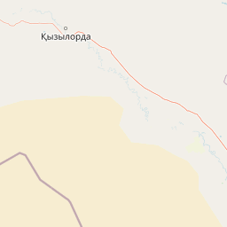
Map view of Kargalinsky Zakaznik

Use this park location map to pinpoint Kargalinsky Zakaznik in Kazakhstan, understand its exact geographic position, and read its mapped placement within the surrounding landscape more clearly.

Pigeon | © OpenStreetMap contributors

Location context for Kargalinsky Zakaznik

Kyzylorda Region
Park atlas

Compare regional river corridors, floodplain reserves, and wildlife habitats.

Parks Near Kargalinsky Zakaznik and Surrounding Protected Areas

Browse other protected areas and reserves located near Kargalinsky Zakaznik in central Kazakhstan. Evaluating adjacent river valley habitats and regional wildlife sanctuaries provides broader context for floodplain conservation.
Watercolor painting of a landscape featuring green hills, grassy foreground, and distant mountains under a soft sky
National parkSouth Kazakhstan Region
About 327 km away#1 closest

Southeast

Sayram-Ugam National Park: Protected Landscape and Geographic Context in South Kazakhstan

Explore dramatic alpine terrain and ancient juniper forests.

Delve into Sayram-Ugam National Park, a protected national park situated in the South Kazakhstan Region. This expansive area showcases striking mountain topography with seven natural altitude zones, from mountain steppe to permanent snowfields. It is distinguished by its vast juniper forests and serves as a crucial conservation site for wild fruit and nut tree genetic diversity, offering a unique lens for understanding Central Asian mountain ecology and landscape context.

Area
1,490 km²
Established
2007
IUCN
II
Relief
Mountain
Watercolor illustration of a mountainous landscape with green valleys, a winding river, and distant purple mountains
National parkTashkent Region
About 346 km away#2 closest

Southeast

Ugam-Chatkal National Park: Mapped Alpine Landscapes of Uzbekistan's Tashkent Region

Explore protected mountain terrain and regional geography.

Ugam-Chatkal National Park is a vast national park located in the Tashkent Region of Uzbekistan, renowned for its spectacular alpine scenery and significant protected mountain landscapes. This protected area covers approximately 668,350 hectares, dominated by the imposing Ugam Range with peaks up to 4,000 meters. The park's terrain features a rich mosaic of ecosystems, from dense forests on northern slopes to more open southern exposures, offering a detailed look at mountain geography and biodiversity within a conservation context. Its designation as a national park underscores its critical role in preserving the natural heritage of this Central Asian region.

Area
6,683.5 km²
Established
1992
IUCN
II
Relief
Mountain
State or regional parkKyrgyzstan
About 379 km away#3 closest

Southeast

Kara-Buura State Nature Park: Kyrgyzstan's Protected Mountain Landscapes and Natural Terrain

Explore the mapped geography and protected area context.

Kara-Buura State Nature Park is a designated state or regional park within Kyrgyzstan, crucial for understanding the country's protected natural areas. Located in the Tian Shan mountain range, the park encompasses diverse alpine and semi-arid landscapes, typical of this high-altitude region. Its mapped boundaries and geographic setting provide valuable context for atlas exploration and appreciating the conservation efforts aimed at preserving Kyrgyzstan's natural heritage, offering a unique lens into the country's mountainous terrain.

IUCN
II
Watercolor painting of a green valley with a winding river and forested hills against a pale, soft-toned sky.
Nature reserveJalal-Abad Region
About 473 km away#4 closest

Southeast

Padyshata State Nature Reserve: Geographic Profile and Protected Forest Atlas

Chatkal Range ecosystems in the western Tien Shan

Covering 158 square kilometers, Padyshata State Nature Reserve is a strictly managed protected area defined by its vertical zonation, ranging from rocky mountain slopes to expansive juniper and Semenov fir forests. This geographic profile outlines the terrain, habitat structure, and the vital role of this reserve within the broader Kyrgyz forest conservation network.

Area
158.46 km²
Established
2003
IUCN
Ia
Relief
Mountain
National parkKyrgyzstan
About 478 km away#5 closest

East

Besh-Tash Nature Park National Park: Mapped Geography and Protected Landscape Identity

Explore the natural terrain and park boundaries in Kyrgyzstan.

Discover Besh-Tash Nature Park, a designated national park located within the mountainous terrain of Kyrgyzstan. This page focuses on its role as a protected landscape, providing insight into its mapped geographic context and regional significance. Understanding Besh-Tash Nature Park involves examining its natural setting and its contribution to conservation efforts in Central Asia, offering a factual atlas perspective for explorers.

National parkJizzakh Region
About 485 km away#6 closest

South

Zaamin National Park: National Park Protected Landscape in Jizzakh Region

Explore its mapped boundaries and natural geography.

Zaamin National Park represents a crucial component of protected natural landscapes within Uzbekistan, situated in the Jizzakh Region. This national park detail page provides essential geographic context, focusing on the park's mapped boundaries and its role as a protected area. Users can delve into the regional geography and landscape features that contribute to Zaamin National Park's unique identity, offering a factual basis for atlas-style exploration and understanding of conservation lands.

Area
156 km²
Established
1926
IUCN
II
Relief
Mountain
Protected areaKyrgyzstan
About 491 km away#7 closest

Southeast

Alatay State Nature Park Protected Area: Mapped Landscape and Regional Geography

Explore the protected boundaries and geographic context of this Kyrgyz natural landscape.

Alatay State Nature Park is a designated protected area within Kyrgyzstan, contributing to the country's vast network of natural landscapes. This page provides detailed geographic information, emphasizing the park's mapped boundaries and its role within the broader regional context of the Tian Shan mountains. It serves as a crucial point for understanding the park's landscape identity and its atlas-level significance as a protected natural territory in Central Asia.

Access
Access unknown
National parkUlytau Region
About 519 km away#8 closest

North

Ulytau National Park: Mapping the Mountain-Steppe Ecosystems of Central Kazakhstan

Protected rocky uplands and sacred steppe landscapes

Ulytau National Park stands as a major protected area in central Kazakhstan, established to unify the management of the Ulytau massif. The park preserves a unique interplay of low mountain ridges, deep intermountain hollows, and semi-arid steppe. It represents a significant effort to secure the geographic and historical integrity of the region, offering a window into the transition between Kazakhstan's open grasslands and its isolated, rugged upland systems.

Area
589.12 km²
Established
2022
IUCN
II
Scope
Terrestrial

Common questions about visiting, size, designation, and location context for Kargalinsky Zakaznik

Kargalinsky Zakaznik FAQs for park facts, access, geography, and protected area context

Find quick answers about Kargalinsky Zakaznik, including protected-area facts, park geography, trail and visitor context, and how the park fits into its surrounding country and regional landscape.
MoriAtlas Explorer

Continue Your Protected Areas Search Across the Global Atlas

Deepen your exploration by continuing the structured search for national parks and protected areas worldwide. Utilize the comprehensive filtering capabilities to compare different conservation landscapes and refine your understanding of global park geography. Discover more about the distribution and characteristics of protected natural areas.

Global natural geography