

Mori Atlas logo
National parkKennedy Range National Park

Explore dramatic sandstone escarpments, deep canyons, and semi-arid terrain within this national park.

Kennedy Range National Park: Protected Landscape Atlas and Map Context in Gascoyne, AU

Kennedy Range National Park represents a significant protected natural landscape within the Gascoyne region of Western Australia. This national park encompasses a prominent, weathered sandstone plateau that rises sharply from the surrounding plains, featuring spectacular cliffs and a complex system of canyons. It offers a unique opportunity for atlas-style discovery, allowing users to understand its mapped boundaries, regional geographic context, and the striking contrast of its terrain against the broader semi-arid environment. Explore the geological heritage and arid-zone ecosystems preserved within this expansive protected area.

Western AustraliaSandstone CliffsCanyon LandscapeArid ZoneIndigenous HeritageWildflower Display

Kennedy Range National Park

National park

Park overview

Structured park overview, official facts, and landscape profile for Kennedy Range National Park

Kennedy Range National Park park facts, protected area profile, and essential visitor context

Review the core facts for Kennedy Range National Park, including designation, size, terrain, visitor scale, habitats, and operating context in one park-focused overview.

About Kennedy Range National Park

Kennedy Range National Park occupies a distinctive place in Western Australia's protected area estate as a representative example of arid-zone sandstone landscape formations in the Gascoyne region. The park's central feature is a vast mesa-like plateau that extends approximately 150 kilometres in length, formed through millions of years of erosion and weathering. The most spectacular aspect of the range is the series of steep canyons that dissect the southern and eastern faces of the plateau, with cliff faces rising dramatically from the valley floors. These sandstone formations create a complex habitat mosaic that supports a diversity of plant and animal species adapted to the harsh semi-arid environment. The park sits on the edge of the Gascoyne River catchment area, with natural springs located along the base of the ranges historically providing crucial water sources for both wildlife and human inhabitants. The landscape represents a natural boundary that historically separated the territories of the Maia and Malgaru Aboriginal peoples, and the area remains culturally significant to the descendants of these communities.

Quick facts and research context for Kennedy Range National Park

Kennedy Range National Park covers 1,416.6 square kilometres of semi-arid landscape in inland Western Australia. The park was officially gazetted in 1993 and is managed by the Western Australia's Department of Environment and Conservation. The formation represents a natural border between the traditional lands of the Maia and Malgaru Aboriginal peoples. The park features limited visitor infrastructure, with basic facilities including a bush toilet and campground at Temple Gorge, and several walking trails that traverse the escarpment and canyon areas.

Protection and recognition

Documenting the regional conservation framework and reservation history since its establishment in 1993.

Protection Status and Environmental Designation of Kennedy Range National Park

Registered conservation records trace the official establishment of Kennedy Range National Park back to its formal designation in 1993. Structured baseline metrics outline the administrative boundaries and protection history of the protected terrain to assist geographical research.

Protection details

Designated year
1993
Transboundary protection
No
Park context

Deeper park guide and search-rich context for Kennedy Range National Park

Kennedy Range National Park history, landscape, wildlife, and travel context

Explore Kennedy Range National Park through its history, landscape character, ecosystems, wildlife, conservation priorities, cultural context, and seasonal travel timing in a structured park guide built for atlas discovery and search intent.

Why Kennedy Range National Park stands out

Kennedy Range is best known for its dramatic sandstone escarpment and canyon system, which stands in sharp contrast to the flat surrounding plains of the Gascoyne region. The park protects one of the most significant geological formations in inland Western Australia, with the weathered plateau serving as a visual landmark across the semi-arid landscape. The range also supports a remarkable display of wildflowers following seasonal rains, with over 80 species including mulla mulla, hakeas, eremophilas, calytrix, verticordias and everlasting daisies. The park's cultural significance is equally notable, with archaeological evidence documenting Indigenous Australian occupation extending back over 20,000 years.

Kennedy Range National Park history and protected-area timeline

The Kennedy Range area has a documented human history spanning more than 20,000 years, with archaeological evidence of Indigenous Australian habitation discovered at over 100 sites throughout the range. The natural springs and chert outcrops provided essential resources for Aboriginal people, supporting hunting activities and supplying stone for tool production. European exploration of the area began in 1858 when Francis Thomas Gregory's expedition reached the range during a broader exploration of Western Australia's interior. Gregory named the range after Arthur Edward Kennedy, who served as Governor of Western Australia at that time, and also named the nearby Lyons River during the same expedition before continuing onward to Mount Augustus. Pastoralists arrived shortly after European exploration, with Charles Brockman establishing Boolathana Station in 1877. The region became successful for wool production until the 1930s, when a combination of overgrazing, prolonged drought and the economic impacts of the Great Depression caused most pastoral operations to fail. The valleys and plains surrounding the range suffered significant land degradation from this period of pastoral activity, though the elevated plateau areas remained relatively intact. The area was explored for mineral potential but no significant mining operations were established. Kennedy Range National Park was officially gazetted in 1993, providing formal protection for the geological and cultural values of the area.

Kennedy Range National Park landscape and geographic character

The defining landscape feature of Kennedy Range National Park is the massive sandstone plateau that rises abruptly from the surrounding semi-arid plains. This mesa formation extends for approximately 150 kilometres, creating a prominent landmark visible across the flat terrain of the Gascoyne region. The southern and eastern faces of the range are marked by spectacular sandstone cliffs, some reaching significant heights above the valley floor. The most striking topographic features are the steep canyons that have been carved into the plateau over geological time, with these gorges cutting deeply into the sandstone and creating sheltered microenvironments within the broader arid landscape. The elevation change from canyon floor to plateau rim reaches approximately 100 metres, providing dramatic contrast in the terrain. The surrounding landscape consists of flat plains and valley floors that form part of the broader Gascoyne River catchment, with the vegetation patterns reflecting the low rainfall and high temperatures typical of this part of inland Western Australia.

Kennedy Range National Park ecosystems, habitats, and plant life

The Kennedy Range supports a distinctive semi-arid ecosystem adapted to the harsh environmental conditions of inland Western Australia. The park's vegetation reflects the variable terrain, with different plant communities occurring across the plateau tops, cliff faces, canyon floors and surrounding plains. The most notable botanical phenomenon occurs following periods of heavy rainfall, when the park comes alive with a diverse display of wildflowers. Over 80 species have been recorded within the park, including mulla mulla, various hakeas, eremophilas, calytrix, verticordias and everlasting daisies. This floral display transforms the typically muted landscape into a vibrant tapestry of colour and represents one of the park's most celebrated natural features. The sandstone cliff faces and canyon walls providehabitat for specialised plant species that are adapted to the vertical terrain and shade conditions found in these areas.

Kennedy Range National Park wildlife and species highlights

The Kennedy Range provides habitat for a range of arid-zone wildlife species adapted to the semi-arid conditions of the Gascoyne region. The park's diverse habitat types, ranging from plateau tops to shaded canyon floors, support different assemblages of animals throughout the year. Notably, a species of lizard known as the Kennedy Range broad-blazed slider (Lerista kennedyensis) has been named after the Kennedy Range, indicating the area's significance as a location for endemic species. The park's water sources, including natural springs where they occur, provide important watering points for wildlife during the dry periods. Birdlife is present throughout the park, with species adapted to arid environments occupying the various habitat zones. The cliff faces and rock outcrops provide nesting habitat for raptors and other bird species that utilise the vertical terrain.

Kennedy Range National Park conservation status and protection priorities

Kennedy Range National Park preserves both significant geological values and important cultural heritage within a semi-arid protected area context. The park protects one of the more notable sandstone plateau formations in Western Australia, representing the geological history and erosion processes that have shaped the Gascoyne region over millions of years. The gazettment of the park in 1993 provided formal protection for the archaeological sites that document over 20,000 years of Indigenous Australian occupation, preserving this cultural heritage alongside the natural values. The relatively intact condition of the plateau areas, which avoided the degradation that affected the surrounding valley and plains during the pastoral era, means the park retains significant ecological integrity. The park also serves as an important reference site for understanding arid-zone ecosystem function and the adaptations of plants and animals to harsh environmental conditions.

Kennedy Range National Park cultural meaning and human context

The Kennedy Range holds deep cultural significance for the Aboriginal peoples of the Gascoyne region, having formed a natural boundary between the traditional lands of the Maia and Malgaru peoples. The natural springs located along the edge of the ranges would have provided crucial water resources and attracted game animals, making the area an important location for hunting and gathering activities. The chert outcrops found throughout the range supplied valuable stone for tool manufacture, evidence of which has been identified at multiple archaeological sites within the park. Over 100 sites have been documented showing evidence of continuous Indigenous Australian habitation spanning more than 20,000 years prior to European settlement, making this one of the longer documented occupation sequences in the Western Australian interior. The park continues to hold significance for Aboriginal communities with connections to the area.

Top sights and standout views in Kennedy Range National Park

The dramatic sandstone escarpment and canyon system of Kennedy Range stands as the park's most distinctive feature, offering visitors the opportunity to walk along cliff tops and descend into deep gorges that carve through the plateau. The wildflower displays that follow seasonal rains transform the landscape, with over 80 species creating vibrant colour across the normally subdued semi-arid terrain. The park preserves evidence of over 20,000 years of continuous Indigenous Australian occupation, making it one of the longest-inhabited areas of inland Australia. The park also provides a contrast to the better-known coastal and maritime attractions of Western Australia, offering visitors an insight into the vast inland landscapes that comprise much of the state.

Best time to visit Kennedy Range National Park

The optimal time to visit Kennedy Range National Park is following periods of heavy rainfall, when the wildflower display brings the landscape to life with colour and the generally harsh conditions of the park are at their most forgiving. The winter months from May to September typically offer more comfortable temperatures for hiking and outdoor activities, though conditions can vary significantly from year to year depending on seasonal weather patterns. Summer temperatures in the inland Gascoyne region can be extremely hot, making outdoor activities during daylight hours challenging. Visitors should be aware that no water is available within the park, so all water supplies must be carried in. The park's remote location means that visitors should be well-prepared for self-sufficient travel and should check current conditions before planning their visit.
Monthly climate preview

Long-term temperature and precipitation trends across the Gascoyne range terrain

Kennedy Range National Park Monthly Climate Patterns and Averages

Long-term measurements at Kennedy Range National Park reveal a highly arid cycle where peak average maximum temperatures exceed forty-four degrees Celsius alongside minimal daily precipitation. Accessing the complete monthly climatology provides a detailed breakdown of historical averages, daily temperature swings, and rainfall trends across the year.
Annual mean24 °C
16 °C32 °C
Jan32°
Feb32°
Mar30°
Apr26°
May21°
Jun17°
Jul16°
Aug18°
Sep20°
Oct24°
Nov27°
Dec30°
Warmest month
January

32 °C

Coolest month
July

16.1 °C

Wettest month
February

1.8 mm/day

Driest month
October

0.1 mm/day

Park location guide

Geography guide, regional context, and park location map for Kennedy Range National Park

Kennedy Range National Park park geography, regions, and map view in Australia

Understand where Kennedy Range National Park sits in Australia through a broader geographic reading of the surrounding landscape, nearby location context, and its mapped position within the national park landscape.

How Kennedy Range National Park fits into Australia

Australia is a constitutional monarchy and federal parliamentary democracy comprising six states and ten territories. With a population of nearly 28 million, it is one of the world's most urbanised countries, with most people concentrated on the eastern seaboard. The country has a high Human Development Index and is known for its cultural diversity, ancient Aboriginal heritage, and unique wildlife.

Wider geography shaping Kennedy Range National Park in Australia

Australia occupies the entire Australian continent, the island of Tasmania, and numerous smaller islands. It is the world's flattest and driest inhabited continent, featuring vast deserts in the interior (the Outback), tropical rainforests along the eastern coast, and a coastline bordering the Indian and Pacific Oceans.

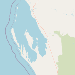
Map view of Kennedy Range National Park

Use this park location map to pinpoint Kennedy Range National Park in Australia, understand its exact geographic position, and read its mapped placement within the surrounding landscape more clearly.

Pigeon | © OpenStreetMap contributors

Location context for Kennedy Range National Park

GascoyneWestern Australia
Recorded earthquake history

Review Documented Earthquake Records for Kennedy Range National Park

Explore the historical seismic record associated with the Gascoyne region and Kennedy Range National Park. MoriAtlas provides a clear catalogue of documented events to assist in understanding the regional geographic and geophysical context through reliable historical data.

Kennedy Range National Park Earthquakes

Catalogued events

2 events

Strongest magnitude

Magnitude 4

Most recent event

Nov 4, 2007

This history includes earthquakes recorded inside the park or within 50 km of its borders

Park atlas

Discover additional protected landscapes and compare regional park geography across the Gascoyne arid zone and beyond

Explore Nearby National Parks and Protected Areas Around Kennedy Range National Park

Browse national parks and protected areas near Kennedy Range National Park, exploring the distinct geological heritage and arid-zone ecosystems of inland Western Australia. Compare these protected landscapes directly, extending your discovery from Kennedy Range's dramatic mesa into the broader regional park geography and conservation efforts.
National parkGascoyne
About 68 km away#1 closest

South

Pimbee National Park: Australian National Park with Gascoyne Regional Geography

Mapped protected boundaries and natural landscape context.

Pimbee National Park represents a key protected area within Australia's vast Gascoyne region. This national park provides a specific geographic focus, allowing for detailed exploration of its mapped boundaries and the surrounding natural landscape. Understanding Pimbee National Park's place within the regional geography of Western Australia is crucial for a comprehensive atlas-driven discovery of the continent's protected lands and their unique terrain.

Established
2023
Climate
Arid
Scope
Terrestrial
Nature reserveWestern Australia
About 153 km away#2 closest

Southwest

Faure Island Nature Reserve: Mapped Geography and Protected Landscapes in Western Australia

Coastal arid-zone sanctuary and bird conservation landscape

Located east of the Peron Peninsula, Faure Island serves as a critical nature reserve within the Shark Bay World Heritage setting. The island offers a study in coastal geography, featuring a mosaic of sandy dunes, tidal flats, and acacia shrublands that support unique bird breeding colonies and restored marsupial populations.

Area
58 km²
Established
1999
Relief
Lowland
Climate
Arid
Marine protected areaWestern Australia
156 km away#3 closest

Northwest

Ningaloo Marine Park: Mapping Western Australia's Protected Marine Geography and Habitats

Examining the oceanic shelf and reef environments of this key marine protected area

Ningaloo Marine Park safeguards a dynamic mosaic of shallow lagoons, reef edges, and deeper slope environments off the coast of Western Australia. This protected expanse is central to the regional conservation of whale shark feeding grounds and humpback whale migratory routes, offering a detailed perspective on the geomorphological character of the Central Western Shelf Transition.

Area
2,435 km²
Established
1987
IUCN
IV
Relief
Lowland
Marine protected areaWestern Australia
160 km away#4 closest

Northwest

Gascoyne Marine Park: Protected Marine Geography and Seafloor Terrain Map

Marine protected area situated along the Western Australian coast

Gascoyne Marine Park encompasses a significant offshore region defined by its shallow continental shelf and varied seafloor structures. This protected marine area supports vital habitats for migratory species and contributes to the broader ecological network of the North-west Marine Parks system, offering a clear view of specialized aquatic environments through detailed mapping.

Area
81,766 km²
Established
2018
IUCN
IV
Relief
Lowland
National parkWestern Australia
162 km away#5 closest

Southwest

Francois Peron National Park: National Park Protected Landscape & Geographic Exploration

Mapped boundaries and regional landscape context in Western Australia.

Delve into the geography of Francois Peron National Park, a designated national park located in Western Australia. This resource provides structured information on its protected landscape, mapped boundaries, and regional setting, offering a clear point of reference for atlas-based geographic discovery. Understand the natural terrain and conservation context of this significant Australian protected area.

Area
525.87 km²
Established
1993
IUCN
II
Relief
Lowland
National parkWestern Australia
166 km away#6 closest

East

Mount Augustus National Park: Western Australia National Park & Protected Landscape

Explore its mapped terrain and regional geographic context.

Mount Augustus National Park represents a significant protected area within the diverse geography of Western Australia. This page serves as a portal to understanding its specific protected landscape characteristics and its contribution to the state's mapped natural areas. Users can explore the park's geographic identity, its defined boundaries, and its role within a broader atlas of protected lands, providing essential context for regional landscape discovery.

Area
91.68 km²
Established
1989
IUCN
III
Relief
Mountain
National parkAustralia
210 km away#7 closest

Northwest

Cape Range (South) National Park: Exploring Australia's Arid Semiarid Landscape Atlas

Mapped protected boundaries and regional terrain in Western Australia.

Cape Range (South) National Park, situated in Western Australia, is a vital protected area safeguarding a significant portion of the Carnarvon xeric shrublands. This national park offers a glimpse into a unique arid-zone landscape defined by low ranges, sandy plains, and characteristic acacia shrubland. Its establishment extends conservation efforts in the Gascoyne region, providing crucial context for mapped geography and the distribution of arid-adapted ecosystems within Australia's broader atlas.

Area
270.72 km²
Established
2020
IUCN
II
Relief
Upland
National parkAustralia
About 219 km away#8 closest

Southwest

Dirk Hartog Island National Park: Australia's Protected Island Geography and National Park Atlas Entry

Mapped boundaries and regional landscape context for Dirk Hartog Island National Park.

This entry provides detailed geographic context for Dirk Hartog Island National Park, a designated national park in Australia. Understand its mapped protected area status, its place within the Australian continent's geography, and its unique landscape identity. Ideal for atlas exploration, this content offers a structured view of the park's terrain and conservation significance.

Common questions about visiting, size, designation, and location context for Kennedy Range National Park

Kennedy Range National Park FAQs for park facts, access, geography, and protected area context

Find quick answers about Kennedy Range National Park, including protected-area facts, park geography, trail and visitor context, and how the park fits into its surrounding country and regional landscape.
MoriAtlas Explorer

Continue Your Protected Areas Search Across the Global Atlas

Deepen your exploration by continuing the structured search for national parks and protected areas worldwide. Utilize the comprehensive filtering capabilities to compare different conservation landscapes and refine your understanding of global park geography. Discover more about the distribution and characteristics of protected natural areas.

Global natural geography