

Mori Atlas logo
National parkDirk Hartog Island National Park

Discover the mapped boundaries and regional context of this significant national park.

Dirk Hartog Island National Park: Australia's Protected Island Landscape and Geographic Identity

Dirk Hartog Island National Park represents a key protected landscape within Australia's vast geography. This page focuses on the park's specific identity as a national park, detailing its mapped boundaries and contribution to the nation's protected areas atlas. Explore the geographic context that defines this unique island environment and understand its place within Australia's broader natural heritage for structured map-based discovery.

Western AustraliaIsland ParksCoastal ParksHistorical SitesShark BayAustralian National Parks

Dirk Hartog Island National Park

National park

Park overview

Structured park overview, official facts, and landscape profile for Dirk Hartog Island National Park

Dirk Hartog Island National Park park facts, protected area profile, and essential visitor context

Review the core facts for Dirk Hartog Island National Park, including designation, size, terrain, visitor scale, habitats, and operating context in one park-focused overview.

About Dirk Hartog Island National Park

Dirk Hartog Island National Park represents a protected area established to preserve both the natural and historical values of Dirk Hartog Island, situated off the western coast of Western Australia in the Shark Bay region. The island gained its place in history when Dutch explorer Dirk Hartog landed there in 1616, becoming the first European to touch the western coast of Australia. This event marked the beginning of European mapping and eventual colonization of the continent's western seaboard. The national park designation reflects the importance of maintaining both the island's ecological integrity and its historical heritage. The park encompasses the terrestrial environments of the island while contributing to the broader conservation framework of the Shark Bay region, which is recognized internationally for its outstanding natural values.

Quick facts and research context for Dirk Hartog Island National Park

Dirk Hartog Island is located in the Indian Ocean off the coast of Shark Bay in Western Australia. The island was the site of the first recorded European landing on Western Australian soil, occurring in 1616 when Dirk Hartog arrived aboard the vessel Eendracht. The island forms part of the Shark Bay World Heritage Area, recognized for its outstanding universal values including diverse marine ecosystems, significant natural habitats, and geological processes.

Protection and recognition

Documented conservation framework, boundary protection data, and international classifications

Dirk Hartog Island National Park Protection Status and Official Designation

Registered data profiles show the official designation details and geographic protection scope of Dirk Hartog Island National Park within global databases. Explorers can verify documented conservation statuses, international program alignments, and transboundary records to understand the park's place in regional environmental networks.

Protection details

Transboundary protection
No
Park context

Deeper park guide and search-rich context for Dirk Hartog Island National Park

Dirk Hartog Island National Park history, landscape, wildlife, and travel context

Explore Dirk Hartog Island National Park through its history, landscape character, ecosystems, wildlife, conservation priorities, cultural context, and seasonal travel timing in a structured park guide built for atlas discovery and search intent.

Why Dirk Hartog Island National Park stands out

The park is best known for its dual significance as both a conservation area protecting Western Australia's island coastal environments and as a site of profound historical importance marking the earliest European contact with this segment of the Australian continent. The island's dramatic coastal scenery, featuring cliffs, beaches, and surrounding waters, represents a distinctive island landscape within the state's protected area network.

Dirk Hartog Island National Park history and protected-area timeline

Dirk Hartog Island holds a unique place in Australian history as the location of the first authenticated European landing on the western coast of the continent. Dutch navigator Dirk Hartog arrived at the island in 1616 during a voyage from the Dutch East Indies, becoming the first European to document his landing on this stretch of the Australian coastline. He left a pewter plate inscribed with his arrival details nailed to a post, which was later replaced by another explorer, William Dampier, in 1699. This early contact predates the more commonly recognized arrival of British settlers in the eighteenth and nineteenth centuries. The island's historical significance led to its inclusion within the protected area system as a national park, preserving both the physical landscape and the cultural memory of these early exploratory encounters that shaped European understanding of the Australian continent.

Dirk Hartog Island National Park landscape and geographic character

Dirk Hartog Island presents a distinctive coastal island landscape characterized by white sandy beaches, rocky headlands, and inland terrain typical of island environments in the Shark Bay region. The island's coastline features dramatic transitions between sandy shores and cliff formations, creating visual diversity across relatively compact terrain. Surrounding waters of the Indian Ocean contribute to the island's coastal character, with marine environments visible from the island's elevated vantage points. The landscape reflects the broader geological and ecological character of the Shark Bay coastline, where island formations rise from shallow seas to create distinctive offshore landforms.

Dirk Hartog Island National Park ecosystems, habitats, and plant life

The island's natural environment reflects the transitional position between temperate and subtropical zones, supporting coastal vegetation communities adapted to island conditions. The surrounding marine environment forms part of the Shark Bay marine ecosystem, recognized for its biodiversity and ecological significance. Coastal dune systems, beach environments, and island interior plant communities contribute to the ecological character of the protected area. The isolation of island environments creates conditions for specialized plant adaptations and represents a distinct habitat type within the broader Shark Bay World Heritage Area.

Dirk Hartog Island National Park wildlife and species highlights

The island supports birdlife typical of coastal Western Australia, with seabird populations utilizing beach and cliff habitats for nesting and feeding. Marine environments surrounding the island provide foraging areas for various seabird species. The Shark Bay region generally supports diverse marine fauna including dolphins, dugongs, and numerous fish species, with these broader populations contributing to the ecological context of the island's surrounding waters. Island habitats also support small terrestrial fauna adapted to coastal island environments.

Dirk Hartog Island National Park conservation status and protection priorities

Dirk Hartog Island National Park contributes to the conservation framework of the Shark Bay World Heritage Area, one of Australia's most significant natural heritage listings. The park protects island ecosystems and historical values within a broader recognized landscape of outstanding universal value. Conservation management balances the preservation of the island's historical significance with protection of natural environments, maintaining both dimensions of the park's identity. The national park status provides institutional protection for the island's landscapes and cultural heritage within Western Australia's protected area network.

Dirk Hartog Island National Park cultural meaning and human context

The island's cultural significance stems from its pivotal role in early European exploration of the Australian continent. The 1616 landing by Dirk Hartog marked the first documented European encounter with Western Australia's coastline, a moment that shifted geographic understanding of the continent's western seaboard. This historical dimension adds cultural layer to the island's identity beyond its ecological values, representing a point of contact between European maritime exploration and the Australian landscape. The site functions as a tangible connection to the earliest phase of European mapping and documentation of the Australian coast.

Top sights and standout views in Dirk Hartog Island National Park

The park offers visitors the opportunity to experience both natural coastal island environments and the historical significance of Australia's earliest European landfall. Visitors can explore beaches and coastal areas while considering the island's role in the narrative of Australian exploration history. The combination of natural landscapes and historical heritage creates a distinctive visitor experience that distinguishes this park from more purely ecological protected areas. The connection to the broader Shark Bay World Heritage Area provides additional context for understanding the island's place within a globally significant landscape.

Best time to visit Dirk Hartog Island National Park

The island is best visited during Western Australia's cooler months from April to October, when temperatures are more moderate and conditions comfortable for outdoor exploration. Summer months can bring extreme heat to the Shark Bay region, potentially limiting visitor activities and comfort. Coastal conditions and marine environments are generally more pleasant during the cooler season, allowing for better appreciation of the island's landscapes and surrounding waters.
Monthly climate preview

Long-term temperature and precipitation records measured at a representative coordinate

Dirk Hartog Island National Park Climate Normals and Weather by Month

Dirk Hartog Island National Park exhibits a measured annual temperature and precipitation rhythm across 1991 to 2020 baseline coordinates. Reviewing the complete twelve-month normals profile provides deeper analytical context on average monthly extremes.
Annual mean22 °C
19 °C25 °C
Jan24°
Feb25°
Mar25°
Apr24°
May23°
Jun21°
Jul20°
Aug19°
Sep20°
Oct20°
Nov21°
Dec23°
Warmest month
March

25.1 °C

Coolest month
August

19.4 °C

Wettest month
June

1.8 mm/day

Driest month
November

0.1 mm/day

Park location guide

Geography guide, regional context, and park location map for Dirk Hartog Island National Park

Dirk Hartog Island National Park park geography, regions, and map view in Australia

Understand where Dirk Hartog Island National Park sits in Australia through a broader geographic reading of the surrounding landscape, nearby location context, and its mapped position within the national park landscape.

How Dirk Hartog Island National Park fits into Australia

Australia is a constitutional monarchy and federal parliamentary democracy comprising six states and ten territories. With a population of nearly 28 million, it is one of the world's most urbanised countries, with most people concentrated on the eastern seaboard. The country has a high Human Development Index and is known for its cultural diversity, ancient Aboriginal heritage, and unique wildlife.

Wider geography shaping Dirk Hartog Island National Park in Australia

Australia occupies the entire Australian continent, the island of Tasmania, and numerous smaller islands. It is the world's flattest and driest inhabited continent, featuring vast deserts in the interior (the Outback), tropical rainforests along the eastern coast, and a coastline bordering the Indian and Pacific Oceans.

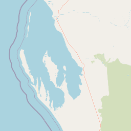
Map view of Dirk Hartog Island National Park

Use this park location map to pinpoint Dirk Hartog Island National Park in Australia, understand its exact geographic position, and read its mapped placement within the surrounding landscape more clearly.

Pigeon | © OpenStreetMap contributors

Location context for Dirk Hartog Island National Park

Western Australia
Park atlas

Compare Western Australia's coastal and island protected areas, tracing the regional geography and conservation landscapes of Shark Bay.

Discover Other National Parks and Protected Areas Near Dirk Hartog Island National Park

Browse a curated selection of national parks and protected areas near Dirk Hartog Island National Park, exploring Western Australia's distinct coastal and island environments. Compare their unique landscapes, conservation priorities, and geographic context to understand the broader protected-area network within the Shark Bay World Heritage Area.
National parkWestern Australia
About 37 km away#1 closest

East

Francois Peron National Park: National Park Protected Landscape & Geographic Exploration

Mapped boundaries and regional landscape context in Western Australia.

Delve into the geography of Francois Peron National Park, a designated national park located in Western Australia. This resource provides structured information on its protected landscape, mapped boundaries, and regional setting, offering a clear point of reference for atlas-based geographic discovery. Understand the natural terrain and conservation context of this significant Australian protected area.

Area
525.87 km²
Established
1993
IUCN
II
Relief
Lowland
Nature reserveWestern Australia
About 84 km away#2 closest

East

Faure Island Nature Reserve: Mapped Geography and Protected Landscapes in Western Australia

Coastal arid-zone sanctuary and bird conservation landscape

Located east of the Peron Peninsula, Faure Island serves as a critical nature reserve within the Shark Bay World Heritage setting. The island offers a study in coastal geography, featuring a mosaic of sandy dunes, tidal flats, and acacia shrublands that support unique bird breeding colonies and restored marsupial populations.

Area
58 km²
Established
1999
Relief
Lowland
Climate
Arid
National parkGascoyne
About 185 km away#3 closest

East

Pimbee National Park: Australian National Park with Gascoyne Regional Geography

Mapped protected boundaries and natural landscape context.

Pimbee National Park represents a key protected area within Australia's vast Gascoyne region. This national park provides a specific geographic focus, allowing for detailed exploration of its mapped boundaries and the surrounding natural landscape. Understanding Pimbee National Park's place within the regional geography of Western Australia is crucial for a comprehensive atlas-driven discovery of the continent's protected lands and their unique terrain.

Established
2023
Climate
Arid
Scope
Terrestrial
Marine protected areaWestern Australia
About 198 km away#4 closest

North

Gascoyne Marine Park: Protected Marine Geography and Seafloor Terrain Map

Marine protected area situated along the Western Australian coast

Gascoyne Marine Park encompasses a significant offshore region defined by its shallow continental shelf and varied seafloor structures. This protected marine area supports vital habitats for migratory species and contributes to the broader ecological network of the North-west Marine Parks system, offering a clear view of specialized aquatic environments through detailed mapping.

Area
81,766 km²
Established
2018
IUCN
IV
Relief
Lowland
National parkGascoyne
About 219 km away#5 closest

Northeast

Kennedy Range National Park: Explore Its Dramatic Sandstone Plateau and Canyon Geography

Discover the protected landscapes of Gascoyne's arid terrain.

Kennedy Range National Park is a protected area defined by its striking geological formations, including a vast sandstone plateau and deeply incised canyons that create a dramatic mesa landscape. Situated in the Gascoyne region, this national park serves as a significant example of Australia's inland semi-arid environments, offering rich context for mapped terrain exploration. Understand the park's protected boundaries, its unique arid-zone ecosystems, and the visual contrast it presents within the regional geography, providing valuable insights for atlas-driven discovery.

Area
1,416.6 km²
Established
1993
IUCN
II
Relief
Highland
National parkWestern Australia
About 222 km away#6 closest

Southeast

Kalbarri National Park: Discover Its Mapped Geography and Protected Landscape Identity

Western Australia's protected national park terrain.

Kalbarri National Park is a vital protected area within the vast geography of Western Australia. This detail entry provides essential context for understanding the park's specific protected landscape, its geographic features, and how it integrates into the broader regional atlas. Explore the mapped boundaries and natural terrain that define Kalbarri National Park, offering a foundation for deeper geographic study and protected-area discovery.

Area
1,830.05 km²
Established
1963
IUCN
II
Relief
Mixed relief
Nature reserveWestern Australia
About 234 km away#7 closest

Southeast

Eurardy Reserve Nature Reserve: Geographic Context and Protected Landscape Profile

Sandplain terrain and conservation corridors in Western Australia

Eurardy Reserve stands as a pivotal nature reserve in Western Australia, offering a unique look at intact sandplain ecosystems and Mallalie scrub associations. Positioned near Kalbarri National Park, the area provides vital habitat connectivity and botanical value. Users can explore its flat, undulating terrain and seasonal landscape transitions through this structured geographic overview of the Mid West region.

Area
300.5 km²
Established
2005
Relief
Lowland
Climate
Mediterranean
Marine protected areaWestern Australia
About 253 km away#8 closest

North

Ningaloo Marine Park: Mapping Western Australia's Protected Marine Geography and Habitats

Examining the oceanic shelf and reef environments of this key marine protected area

Ningaloo Marine Park safeguards a dynamic mosaic of shallow lagoons, reef edges, and deeper slope environments off the coast of Western Australia. This protected expanse is central to the regional conservation of whale shark feeding grounds and humpback whale migratory routes, offering a detailed perspective on the geomorphological character of the Central Western Shelf Transition.

Area
2,435 km²
Established
1987
IUCN
IV
Relief
Lowland

Common questions about visiting, size, designation, and location context for Dirk Hartog Island National Park

Dirk Hartog Island National Park FAQs for park facts, access, geography, and protected area context

Find quick answers about Dirk Hartog Island National Park, including protected-area facts, park geography, trail and visitor context, and how the park fits into its surrounding country and regional landscape.
MoriAtlas Explorer

Continue Your Protected Areas Search Across the Global Atlas

Deepen your exploration by continuing the structured search for national parks and protected areas worldwide. Utilize the comprehensive filtering capabilities to compare different conservation landscapes and refine your understanding of global park geography. Discover more about the distribution and characteristics of protected natural areas.

Global natural geography