
Why Kiesgrube Laukertsberg bei Nieder-Mörlen stands out
Kiesgrube Laukertsberg is best known as a textbook example of a post-industrial gravel pit that has been deliberately converted into a protected habitat reserve. After more than three decades of extracting Nauheimer Kantkies and sand, the cessation of quarrying in 2010 left behind a raw landscape of bare gravel, shallow pools, and disturbed ground that proved ideal for pioneer species. The reserve has become especially valued for its population of natterjack and green toads, its nesting little ringed plovers, and the presence of eagle owls in the surrounding wooded edges. The site is also notable within the regional conservation network of the Wetteraukreis, where it completes a picture of small, specialized nature reserves that protect quarry sites, saline meadows, river floodplains, and other unusual habitat types. Its designation process itself is a point of interest: the Regierungspräsidium Darmstadt provisionally secured the area in 2017 before the formal 2019 protection order, and in 2023 it rejected municipal plans to convert the former quarry floor into a ground-mounted photovoltaic installation, affirming the site's ecological priority over renewable energy development at this location.
Kiesgrube Laukertsberg bei Nieder-Mörlen history and protected-area timeline
The history of Kiesgrube Laukertsberg begins not as a protected area but as an industrial site. Mining of the Nauheimer Kantkies quartz gravel and the associated sand deposits began in the western field in 1977, and the operation became one of several active extraction sites in the Wetterau lowlands. From 1993 onward, a separate eastern field was quarried across the L 3134 road. For decades the landscape at Laukertsberg was shaped primarily by machinery, by the removal of sand and gravel, and by the gradual expansion of the working pit.
The decisive shift came in 2010, when gravel extraction at the site was completely halted. The processing plant that had dominated the western field remained in place for several more years before being dismantled between 2017 and 2018. With extraction stopped and infrastructure progressively removed, the question of the site's future use came to the foreground. Recognizing the habitat that had developed on the abandoned quarry floor, the Regierungspräsidium Darmstadt intervened in 2017 by provisionally securing the area under Hessian nature protection law to prevent further changes.
An expert assessment subsequently confirmed the conservation value of the western field, and on 24 October 2019 the area was formally placed under protection by statutory order as the Naturschutzgebiet Kiesgrube Laukertsberg bei Nieder-Mörlen. The protection explicitly covers only the western field, leaving the eastern field under separate management by the former operator Cemex, which has planted woodland and an orchard meadow there. In 2023 the city of Bad Nauheim explored the possibility of installing a ground-mounted photovoltaic array on the reserve, but the higher nature protection authority rejected the proposal, reinforcing the site's status as a habitat reserve rather than an energy development site.
Kiesgrube Laukertsberg bei Nieder-Mörlen landscape and geographic character
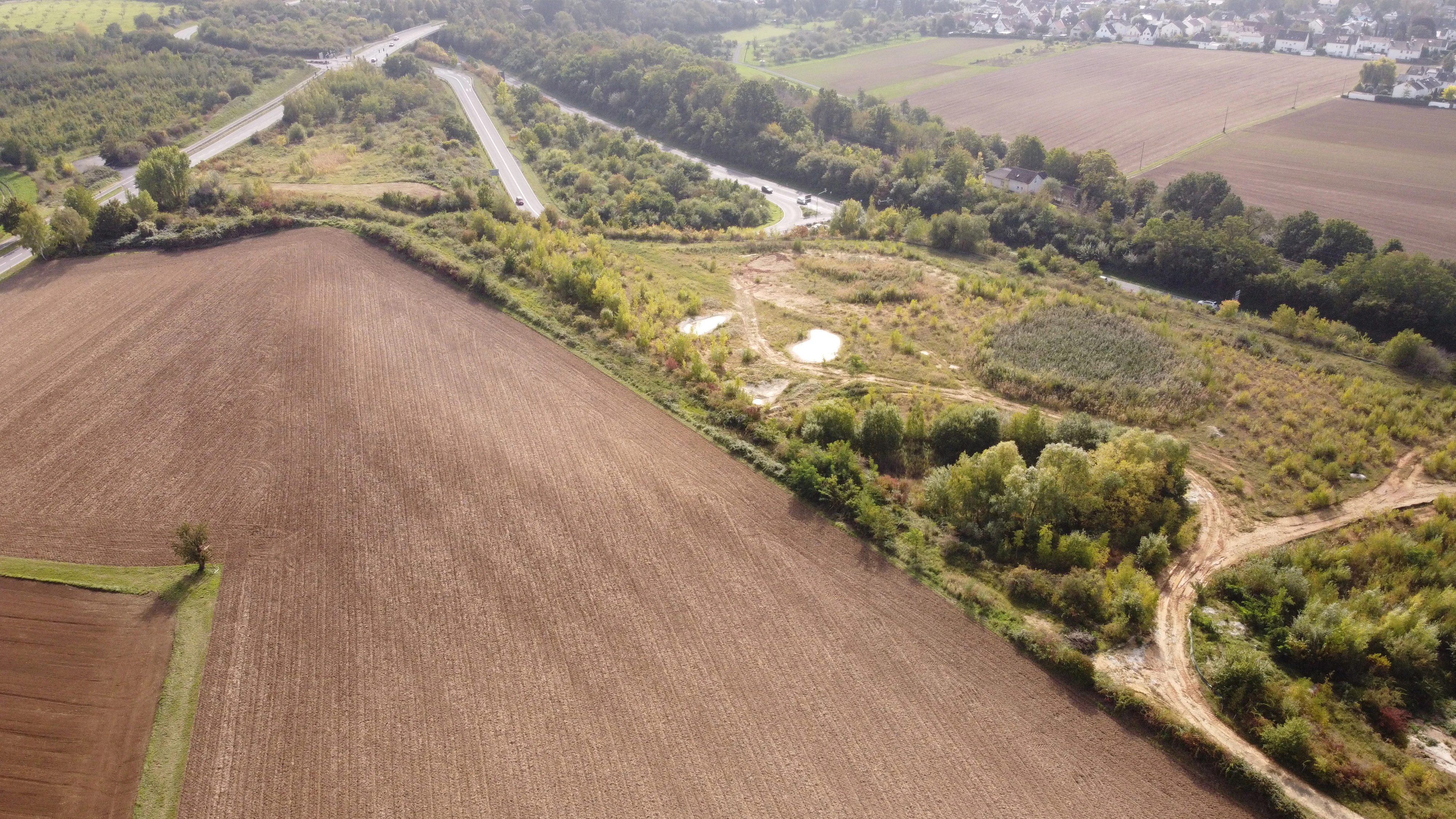
The landscape of Kiesgrube Laukertsberg is the landscape of an exhausted quarry rather than a natural landform. The reserve consists of the western field of the original pit, an area of roughly 15.7 hectares dominated by exposed gravel and sand surfaces, irregular basins, embankments, and zones of incipient vegetation growth. Substrate exposed by decades of extraction dominates the visual character of the site, giving it the rough, light-coloured appearance typical of inland gravel workings in central Germany.
Topographically the reserve sits in the gently undulating Wetterau, a lowland basin north of Frankfurt that is characterized by agricultural plains, river valleys, and scattered settlements. The quarry itself lies on land whose historic field name was Lauk-Hart-Berg, and the working of the gravel deposit has carved a distinctive depression into this low rise. To the south the site's connection to Nieder-Mörlen is interrupted by the combined corridor of the Bundesstraße 3 and the Main-Weser railway, giving the reserve a strongly enclosed character.
The eastern field of the former quarry, separated by the L 3134 state road, provides a contrasting landscape. Where the western field is maintained primarily as open quarry habitat, the eastern field has been deliberately transformed by woodland planting and the establishment of an orchard meadow by the former operator Cemex. Together the two sides illustrate the two possible directions a former extraction site can take: one toward protected open-ground habitat, the other toward managed forest and traditional orchard landscapes.
Kiesgrube Laukertsberg bei Nieder-Mörlen ecosystems, habitats, and plant life
The nature of the reserve is shaped by its industrial origins rather than by any undisturbed ecological baseline. Because the quarry exposed mineral subsoils and created irregular surfaces with variable drainage, the vegetation that has developed since mining ended is sparse, patchy, and dominated by pioneer species. Bare gravel and sand still occupy significant portions of the site, while grasses, herbs, and low shrubs have colonised the more stable areas, creating a dynamic mosaic of bare ground and early-successional plant communities.
These conditions are particularly valuable for species that require open, warm, mineral-rich substrates. Insects that depend on sparsely vegetated ground thrive here, including groups that have become uncommon in the surrounding intensively farmed Wetterau. The varied microtopography of the former quarry, with its ridges, hollows, and seasonal pools, also creates the warm, shallow water bodies and damp hollows that amphibians need for breeding, while exposed banks and flats provide nesting sites for ground-nesting birds.
Although the formally protected area covers only the western field, the broader quarry complex functions as a single ecological unit with the eastern field beyond the L 3134. The woodland plantings and orchard meadow on the eastern side offer different but complementary habitat to the open reserve, supporting woodland and orchard species in close proximity to the open-ground specialists of the protected area. This juxtaposition gives the Laukertsberg site a layered ecological identity that combines quarry, pioneer grassland, young woodland, and traditional orchard within a very compact footprint.
Kiesgrube Laukertsberg bei Nieder-Mörlen wildlife and species highlights
The wildlife of Kiesgrube Laukertsberg is concentrated around species that benefit from the open, disturbed character of the former quarry. Amphibians are a particular focus of the reserve's conservation interest. The site supports populations of the natterjack toad, a species that favours warm, open habitats with loose sandy soils and shallow breeding pools, as well as the green toad, another species that has retreated from much of the surrounding agricultural landscape. These amphibians find in the residual quarry structures an unusually favourable combination of breeding habitat and terrestrial cover.
Birds are the other major wildlife group highlighted in the reserve's profile. Little ringed plovers, a ground-nesting wader that colonises freshly exposed gravel and sand near water, breed on the site, taking advantage of the bare substrates left by former extraction. Eagle owls have also been recorded in the area, using the mix of quarry, woodland edges, and cliff-like quarry faces as hunting and roosting habitat. Beyond these headline species, the reserve supports a broader community of birds typical of open and semi-open landscapes in the Wetterau.
The insect fauna of Kiesgrube Laukertsberg is closely tied to the pioneer vegetation and warm bare ground that cover much of the western field. The combination of mineral substrates, early-successional plants, and shallow water provides breeding and feeding opportunities for a wide range of beetles, bees, wasps, and other insects that have become rare in more intensively managed landscapes. Together with the amphibian and bird communities, these insects confirm the reserve's role as a stronghold of species that depend on disturbed open habitats in a region where such habitats are increasingly scarce.
Kiesgrube Laukertsberg bei Nieder-Mörlen conservation status and protection priorities
From a conservation perspective, Kiesgrube Laukertsberg bei Nieder-Mörlen is significant as a protected area that converts a former industrial site into functioning habitat. The reserve is classified under IUCN Category IV, a designation that emphasizes the active management of specific habitats and species rather than the broad-scale protection of natural or near-natural ecosystems. This classification reflects the site's character: a managed mosaic of bare ground, pioneer vegetation, and water bodies that together support a defined suite of protected amphibians, insects, and birds.
The process by which the site achieved protection is itself a notable example of conservation administration in Hesse. The Regierungspräsidium Darmstadt provisionally secured the area in 2017 to prevent further deterioration, and an expert assessment subsequently demonstrated the site's conservation value. The formal protection order of 24 October 2019 then placed the western quarry field permanently under nature conservation law, restricting public access under Hessian mining regulations and blocking former access routes with gates and fences.
The reserve also illustrates the tension that can arise between conservation and competing land-use pressures. In 2023 the city of Bad Nauheim considered developing a ground-mounted photovoltaic installation on the former quarry floor, but the higher nature protection authority rejected the proposal, prioritizing the site's ecological function over its potential for renewable energy generation. This decision underlined both the legal weight of the 2019 protection order and the broader importance of preserving rare open-ground habitat in the Wetterau lowlands.
Kiesgrube Laukertsberg bei Nieder-Mörlen cultural meaning and human context
The cultural context of Kiesgrube Laukertsberg is rooted in the long relationship between the Wetterau landscape and the extraction of mineral resources. The gravel and sand deposits of the region have been economically important for decades, and the quarrying of Nauheimer Kantkies from 1977 onward tied the Laukertsberg site into a wider network of working pits in and around Bad Nauheim. The reserve's name preserves a fragment of this local identity: Lauk-Hart-Berg is a historic field name that reflects older patterns of land use and naming in the area.
Today the reserve sits at the boundary between town and countryside, with Nieder-Mörlen and Steinfurth on one side and the busy corridor of the Bundesstraße 3 and the Main-Weser railway on the other. This position on the urban fringe of Bad Nauheim gives the site a particular local significance: it functions as a nearby patch of semi-natural open landscape within easy reach of the town, even though the reserve is not open to the public. Its conservation value is therefore closely linked to the identity of Bad Nauheim as a town that combines urban development, transport infrastructure, and surviving fragments of unusual habitat.
Top sights and standout views in Kiesgrube Laukertsberg bei Nieder-Mörlen
Kiesgrube Laukertsberg stands out for the contrast between its industrial past and its current conservation role. The combination of bare gravel, seasonal pools, pioneer vegetation, and surrounding woodland creates habitat for natterjack toads, green toads, little ringed plovers, and eagle owls, species that have become scarce across the wider Wetterau. Its designation as a Hessian nature reserve in 2019, after provisional protection from 2017, marks the site as a deliberate success in reclaiming industrial land for biodiversity.
Best time to visit Kiesgrube Laukertsberg bei Nieder-Mörlen
The reserve is not open to public access, as entry to the former quarry is prohibited under Hessian mining regulations and all former approach routes have been sealed with gates and fences. As a result, the site is best appreciated through observation from public roads and paths around Bad Nauheim, especially during spring and summer when amphibian breeding activity and ground-nesting birds are at their peak. Viewers interested in the reserve's seasonal character can note that the open quarry surfaces and shallow pools are most visible in late spring and early summer, while the surrounding woodland edges of the eastern field show their strongest colour in autumn.