

Mori Atlas logo
Nature reserveKillabakh Nature Reserve

Examining the ecological connectivity and steep forested terrain of this significant Australian nature reserve

Killabakh Nature Reserve: A Protected Forest Landscape on the Great Eastern Escarpment of New South Wales

Killabakh Nature Reserve represents a critical protected forest block on the Mid North Coast of New South Wales. Situated on the eastern slopes of the Great Dividing Range, this area encompasses rugged, dissected terrain that supports a moist microclimate for wet sclerophyll eucalyptus stands and lush rainforest patches. The reserve serves as an essential component of the Great Eastern Escarpment connectivity network, preserving mountain ecosystems and dense forest cover within a broader wilderness matrix.

wet sclerophyll forestrainforesteucalyptus forestGreat Dividing RangeGreat Eastern EscarpmentMid North Coast
An illustrative depiction of a winding trail leading toward a waterfall flanked by tall trees and mountains under a warm sky.

Killabakh Nature Reserve

Nature reserve

Park overview

Structured park overview, official facts, and landscape profile for Killabakh Nature Reserve

Killabakh Nature Reserve park facts, protected area profile, and essential visitor context

Review the core facts for Killabakh Nature Reserve, including designation, size, terrain, visitor scale, habitats, and operating context in one park-focused overview.

About Killabakh Nature Reserve

Killabakh Nature Reserve occupies a significant forested position on the Mid North Coast of New South Wales, set against the eastern slopes of the Great Dividing Range. Stretching across several thousand hectares, the reserve encapsulates one of the more intact examples of the wet sclerophyll forests that historically dominated the eastern rim of the range, where moist conditions moderated by coastal rainfall have allowed tall eucalyptus canopies to develop alongside pockets of rainforest.

Designated as a strict nature reserve under international IUCN-style categories, Killabakh sits at the more conservation-focused end of the New South Wales protected-area spectrum. It is not positioned as a recreational destination in the same way as neighbouring state forests or recreation-oriented parks, but instead serves as a long-term refuge for native forest ecosystems in a landscape where logging and land clearing have historically reduced forest cover. The site is administered by the NSW National Parks and Wildlife Service, which oversees conservation management across the state's formal reserve network.

The reserve is one component of a broader escarpment conservation footprint that also includes the Coxcomb and Goonook nature reserves. Read together, these three reserves create a meaningful cluster of protected land along the Great Eastern Escarpment, a landscape feature seen as pivotal to retaining ecological connectivity for mountain ecosystems running the length of eastern Australia. Killabakh's contribution within this network is its wet forest character and its place within the broader corridor that links coastal and upper-escarpment habitats.

Quick facts and research context for Killabakh Nature Reserve

Killabakh Nature Reserve is a strict nature reserve on the Mid North Coast of New South Wales, located about 30 kilometres north of Taree along the Great Eastern Escarpment of the Great Dividing Range. Established in January 1999, it is managed by the NSW National Parks and Wildlife Service and covers roughly 2,644 hectares of wet sclerophyll eucalyptus forest and rainforest. Its name comes from the Worimi word for the Sydney blue gum, a tree that features prominently in the reserve's canopy.

Protection and recognition

Examine documented terrestrial protection metrics and official designation records for Killabakh Nature Reserve.

Killabakh Nature Reserve Protection Status and Recognized Conservation Scope

Killabakh Nature Reserve holds a documented terrestrial protection scope within its designated conservation framework. Structured records compile available management parameters and international recognition data for the protected area.

Protection details

Protection scope
Terrestrial
Transboundary protection
No
Park context

Deeper park guide and search-rich context for Killabakh Nature Reserve

Killabakh Nature Reserve history, landscape, wildlife, and travel context

Explore Killabakh Nature Reserve through its history, landscape character, ecosystems, wildlife, conservation priorities, cultural context, and seasonal travel timing in a structured park guide built for atlas discovery and search intent.

Why Killabakh Nature Reserve stands out

The reserve is best known for its extensive stands of wet sclerophyll eucalyptus forest interspersed with rainforest patches, and for its position within a small network of protected escarpment reserves on the Great Dividing Range. Its link to the Worimi language and the Sydney blue gum gives it a distinctive cultural and botanical identity among New South Wales nature reserves.
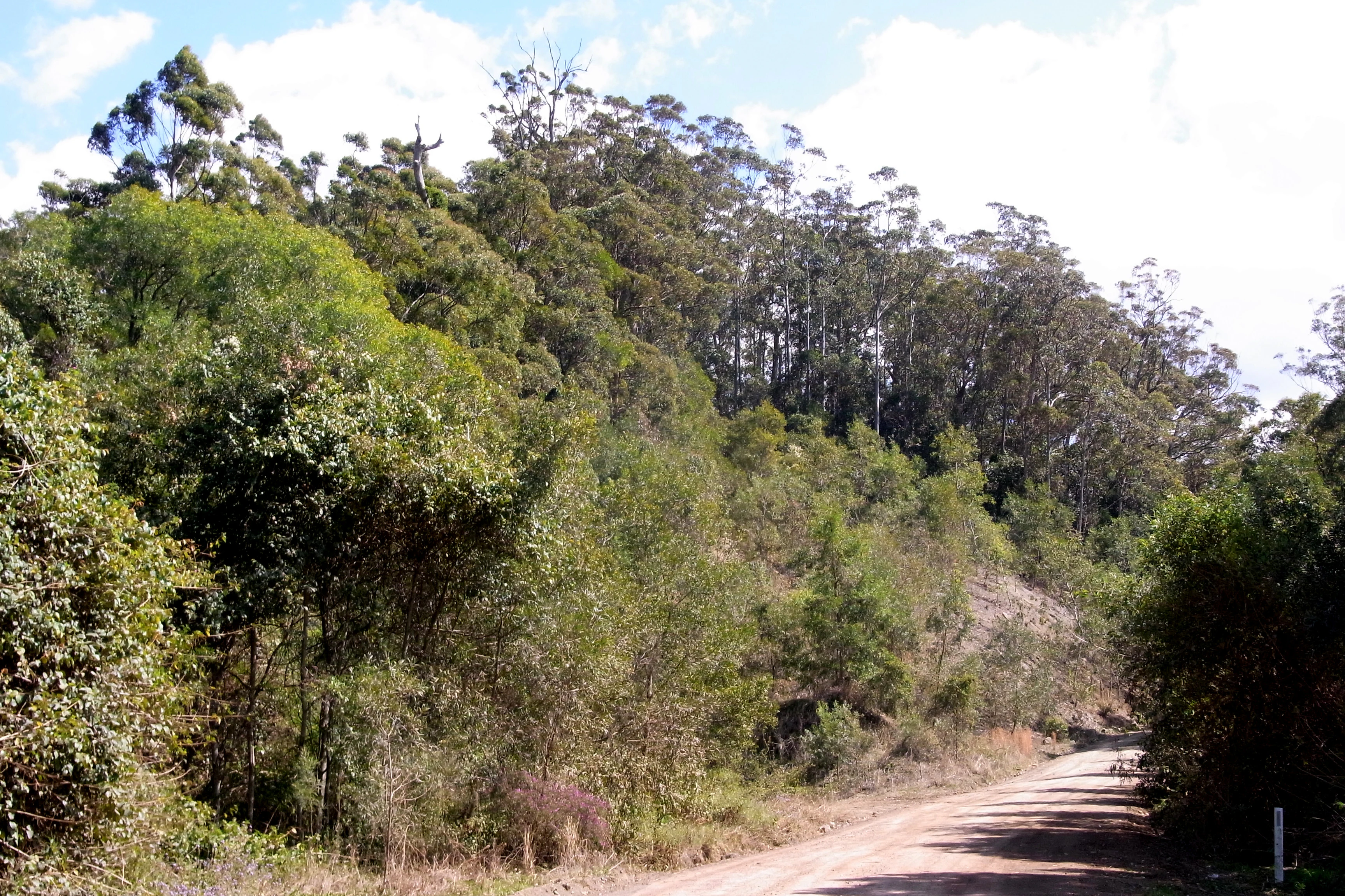
A dirt road leading into a dense, forested area with tall eucalyptus trees and lush undergrowth in Killabakh Nature Reserve.
A dirt road winding through the dense vegetation of Killabakh Nature Reserve.

Killabakh Nature Reserve history and protected-area timeline

Killabakh Nature Reserve was formally established in January 1999, creating a long-term protected estate over a large block of existing wet sclerophyll and rainforest habitat on the Mid North Coast of New South Wales. Its creation added to a growing cluster of nature reserves along the Great Eastern Escarpment of the Great Dividing Range, joining neighbouring Coxcomb and Goonook nature reserves in what is collectively recognised as a key network for conserving mountain ecosystems in eastern Australia.

Management of the reserve has been entrusted to the NSW National Parks and Wildlife Service, integrating it into the state's broader system of formal protected areas rather than treating it as a standalone conservation project. The 1999 designation reflected an increasing emphasis during that period on securing remaining tracts of eastern Australian wet forest as dedicated nature reserves, separate from state forests managed for timber production.

Killabakh Nature Reserve landscape and geographic character

The reserve's landscape is shaped by its position on the eastern fall of the Great Dividing Range, where the Great Eastern Escarpment produces steep, dissected terrain descending towards the coast. Within this setting, Killabakh encompasses rugged forested country rather than open plains, with elevations and slopes that support a moist, sheltered microclimate.

The terrain is dominated by forest cover, with little cleared land within reserve boundaries. Drainage lines and sheltered gullies support rainforest patches, while broader ridges and slopes carry the wet sclerophyll eucalyptus forest that defines much of the reserve. The surrounding regional landscape is similarly forested, giving Killabakh a sense of being embedded within a larger, continuous forest matrix that extends along the escarpment.

Killabakh Nature Reserve ecosystems, habitats, and plant life

Ecologically, Killabakh belongs to the moist eastern Australian forest zone, where high rainfall and proximity to the coast maintain consistently humid conditions. Its vegetation is dominated by wet sclerophyll forest, a distinctive Australian formation in which tall eucalyptus trees form an open canopy over a moist understorey of small trees, ferns, and grasses that thrive in the sheltered, damp conditions below.

Interspersed within the wet sclerophyll forest are stands of subtropical and warm temperate rainforest, occupying the most sheltered and water-retentive sites such as gullies and lower slopes. This juxtaposition of open eucalyptus canopy and denser rainforest patches is characteristic of the eastern escarpment forests in New South Wales and gives Killabakh a layered habitat structure that supports a wide range of forest-dwelling species. The Sydney blue gum, from which the reserve takes its Worimi name, is a keystone canopy species within this system.

Killabakh Nature Reserve wildlife and species highlights

The reserve's wet forest and rainforest habitats support typical communities of forest-dwelling fauna associated with the eastern New South Wales escarpment. The mosaic of open-canopy wet sclerophyll and denser rainforest provides habitat structure for arboreal mammals, ground-dwelling marsupials, and a rich bird community that responds to the vertical layering of the forest. Such forests are commonly used by honeyeaters, parrots, and other canopy-feeding birds, while the moist understorey and litter environment supports amphibians and reptiles adapted to damp, shaded conditions.

While detailed species lists for Killabakh specifically are not broadly documented in available sources, the reserve's ecological context places it firmly within habitat types recognised for supporting a wide range of native forest wildlife, including species sensitive to disturbance and fragmentation. Its role as a strict nature reserve reinforces its function as a refuge habitat rather than an intensively managed recreational area.

Killabakh Nature Reserve conservation status and protection priorities

Killabakh's conservation significance lies primarily in its role as a large contiguous block of wet sclerophyll forest and rainforest on one of the more ecologically important landscape features in eastern Australia, the Great Eastern Escarpment of the Great Dividing Range. As a strict nature reserve, it sits within the more restrictive end of the protected-area spectrum, prioritising biodiversity protection over recreation and other uses.

The reserve forms part of a small network of linked nature reserves, including Coxcomb and Goonook, that together contribute to efforts to maintain and reconnect mountain ecosystems along the length of eastern Australia. This landscape-level connectivity is widely recognised as critical for the long-term viability of forest-dependent species, particularly in a region where historical land use has fragmented native vegetation. By holding extensive forest cover under formal protection, Killabakh supports both local species persistence and broader continental-scale conservation objectives.

Killabakh Nature Reserve cultural meaning and human context

The name Killabakh is drawn from the Worimi language, the tongue of an Aboriginal people whose traditional lands extend through parts of coastal and near-coastal New South Wales. In Worimi, the word refers to the Sydney blue gum, a eucalyptus species that is both a prominent tree within the reserve and a culturally recognised feature of the landscape.

The retention of an Aboriginal language name for the reserve reflects the broader pattern in New South Wales of formally acknowledging Indigenous place names and their connection to the land. Beyond the naming itself, the reserve falls within a landscape of longstanding Aboriginal connection, with the Worimi and neighbouring groups having inhabited and utilised the forests of the eastern escarpment for millennia prior to European settlement.

Top sights and standout views in Killabakh Nature Reserve

Killabakh stands out for combining a sizeable protected forest estate with a distinctive ecological and cultural profile. Its combination of wet sclerophyll eucalyptus forest and rainforest patches on the Great Eastern Escarpment places it within one of the more ecologically significant landscape settings in eastern Australia.

The reserve's integration into the Coxcomb, Goonook, and Killabakh network gives it added value beyond its own boundaries, contributing to landscape-scale connectivity. Its Worimi-language name, drawn from the Sydney blue gum, anchors it firmly within the cultural and botanical heritage of the New South Wales Mid North Coast.

Best time to visit Killabakh Nature Reserve

As a strict nature reserve rather than a recreation-focused park, Killabakh does not have a well-documented public visitor season in available sources. For general appreciation of forests of this type in eastern New South Wales, spring and early summer tend to be favourable periods, when milder temperatures and active growth in the understorey highlight the layered character of wet sclerophyll and rainforest vegetation. Autumn can also offer pleasant walking conditions and changing light through the canopy, although cool, wet weather can occur at any time of year in this coastal-escarpment setting.

Monthly climate preview

Long-term representative temperature and precipitation averages across twelve months

Killabakh Nature Reserve Climate Normals and Annual Weather Patterns

Representative coordinate records show measured monthly temperature ranges and precipitation rates spanning a full annual cycle at Killabakh Nature Reserve. Complete twelve-month climate normals provide deeper insight into long-term averages for detailed environmental analysis.
Annual mean17 °C
11 °C23 °C
Jan23°
Feb22°
Mar20°
Apr18°
May15°
Jun12°
Jul11°
Aug13°
Sep16°
Oct18°
Nov20°
Dec21°
Warmest month
January

22.8 °C

Coolest month
July

11.5 °C

Wettest month
February

6 mm/day

Driest month
August

1.6 mm/day

Park location guide

Geography guide, regional context, and park location map for Killabakh Nature Reserve

Killabakh Nature Reserve park geography, regions, and map view in Australia

Understand where Killabakh Nature Reserve sits in Australia through a broader geographic reading of the surrounding landscape, nearby location context, and its mapped position within the national park landscape.

How Killabakh Nature Reserve fits into Australia

Australia is a constitutional monarchy and federal parliamentary democracy comprising six states and ten territories. With a population of nearly 28 million, it is one of the world's most urbanised countries, with most people concentrated on the eastern seaboard. The country has a high Human Development Index and is known for its cultural diversity, ancient Aboriginal heritage, and unique wildlife.

Wider geography shaping Killabakh Nature Reserve in Australia

Australia occupies the entire Australian continent, the island of Tasmania, and numerous smaller islands. It is the world's flattest and driest inhabited continent, featuring vast deserts in the interior (the Outback), tropical rainforests along the eastern coast, and a coastline bordering the Indian and Pacific Oceans.

Map view of Killabakh Nature Reserve

Use this park location map to pinpoint Killabakh Nature Reserve in Australia, understand its exact geographic position, and read its mapped placement within the surrounding landscape more clearly.

Pigeon | © OpenStreetMap contributors

Location context for Killabakh Nature Reserve

New South Wales

Visual exploration of wet sclerophyll eucalyptus forests, rugged terrain, and protected habitats along the Great Eastern Escarpment.

Killabakh Nature Reserve Landscape Photos and Escarpment Scenery

Visual documentation of Killabakh Nature Reserve captures the dense forest canopies, steep dissected terrain, and sheltered rainforest gullies defining the eastern fall of the Great Dividing Range. Photographic records provide clear environmental context for understanding the protected landscapes, native eucalyptus stands, and conservation character of New South Wales mountain ecosystems.

A dirt road leading into a dense, forested area with tall eucalyptus trees and lush undergrowth in Killabakh Nature Reserve.

Park atlas

Compare surrounding forest reserves and mountain ecosystems along the Great Eastern Escarpment

Other Parks and Protected Areas Near Killabakh Nature Reserve

Browse nearby protected landscapes that share the forest matrix and mountainous terrain surrounding Killabakh Nature Reserve. Expanding the search reveals connected conservation estates and regional park geography across the Mid North Coast.
Nature reserveNew South Wales
About 2.1 km away#1 closest

North

Boorganna Nature Reserve: Protected Rainforest Mapping and Geographic Overview

Essential geographic context on the Comboyne Plateau in New South Wales

Boorganna Nature Reserve preserves a vital corridor of subtropical and warm temperate rainforest within the Comboyne Plateau of New South Wales. By mapping the deep basalt loams and rugged gully terrain, this overview highlights the reserve as a significant historical refuge for diverse forest types and endemic plant species. Analyze the landscape composition, elevation shifts, and the structural integrity of this protected environmental boundary.

Area
4 km²
Established
1904
IUCN
Ia
Relief
Upland
National parkNew South Wales
About 11 km away#2 closest

Southeast

Coorabakh National Park: A Protected Volcanic Landscape in New South Wales

Discover unique terrain, mapped protected boundaries, and regional geography.

Coorabakh National Park in New South Wales, Australia, is characterized by its striking volcanic trio: Big Nellie, Flat Nellie, and Little Nellie. These peaks dominate the rugged escarpment terrain, offering a unique geographic vista. The park protects a rich mosaic of tall eucalypt forests and sheltered subtropical rainforest gullies, highlighting its ecological diversity. For those interested in atlas-style exploration, Coorabakh National Park provides a clear example of a protected landscape with significant geological and ecological features within the broader regional context of New South Wales.

Area
18 km²
Established
1999
IUCN
II
Relief
Highland
National parkMid North Coast
About 11 km away#3 closest

West

Tapin Tops National Park: Protected Landscape in Mid North Coast, Australia

Mapped geographic context and natural terrain discovery.

Tapin Tops National Park is a designated national park offering rich opportunities for geographic and landscape exploration. This detail page provides a structured look at its protected area status and its location within the Mid North Coast region of Australia. Delve into the mapped boundaries and understand the park's specific natural terrain for comprehensive atlas-based discovery.

Area
110 km²
Established
1999
IUCN
II
Relief
Mountain
National parkNew South Wales
About 13 km away#4 closest

Northwest

Biriwal Bulga National Park: Protected Landscape and Geographic Context within New South Wales

Explore mapped boundaries and the national park's regional setting.

Biriwal Bulga National Park represents a significant protected area within New South Wales, Australia, offering crucial insights into the region's natural landscape geography. This dedicated page details the park's specific identity as a national park, focusing on its mapped geographic boundaries and its contribution to the broader atlas of protected lands. It is designed for users who require structured information about individual protected areas and their precise location and landscape context.

Area
65.28 km²
Established
1999
IUCN
II
Relief
Lowland
National parkNew South Wales
About 20 km away#5 closest

Northeast

Bago Bluff National Park: New South Wales National Park with Panoramic Views

Explore its mapped geography and protected forest landscapes.

Bago Bluff National Park in New South Wales presents a remarkable protected landscape characterized by its prominent bluff formation, offering breathtaking panoramic views over the Hastings Valley. This national park preserves extensive wet sclerophyll forests and eucalypt woodlands, contributing to a rich mosaic of natural habitats and supporting a vibrant bird population. The park's geography is deeply tied to its geological history, with local quarries revealing significant fossil specimens. As a key protected area, it provides valuable context for understanding the regional landscape and mapped natural terrain of eastern Australia.

Area
40.23 km²
Established
1999
IUCN
II
Relief
Upland
Nature reserveNew South Wales
About 24 km away#6 closest

South

Wingham Brush Nature Reserve: Protected Rainforest and Manning River Floodplain Geography

An essential ecological sanctuary in coastal New South Wales.

Wingham Brush Nature Reserve represents a critical protected landscape featuring subtropical rainforests on the Manning River floodplain. This unique site, known for its massive Moreton Bay figs and successful regeneration methods, provides a sanctuary for avian and reptilian life amidst the broader coastal plains of eastern Australia.

Area
0.08 km²
Established
2000
IUCN
IV
Relief
Lowland
National parkNew South Wales
About 24 km away#7 closest

East

Middle Brother National Park: New South Wales Protected Area and Geographic Exploration

Mapped boundaries and regional landscape context for this national park.

Middle Brother National Park represents a distinct protected landscape within the state of New South Wales, Australia. This entry offers detailed geographic context, focusing on the park's mapped boundaries and its significance as a national park. Users can explore its place within the regional geography of New South Wales, gaining a structured understanding of this protected area through an atlas-focused perspective.

Area
18.3 km²
Established
1999
IUCN
II
Relief
Mountain
National parkNew South Wales
About 27 km away#8 closest

Northwest

Cottan-Bimbang National Park: A Protected Landscape in New South Wales

Explore its mapped boundaries and regional geographic context.

Delve into the protected landscape of Cottan-Bimbang National Park, a key national park situated in New South Wales, Australia. This page provides detailed insight into its geographic setting and mapped park boundaries, offering a clear understanding of its regional importance. Discover the distinct natural landscape characteristics that define Cottan-Bimbang National Park within the broader Australian atlas.

Area
269 km²
Established
1999
IUCN
II
Climate
Temperate

Common questions about visiting, size, designation, and location context for Killabakh Nature Reserve

Killabakh Nature Reserve FAQs for park facts, access, geography, and protected area context

Find quick answers about Killabakh Nature Reserve, including protected-area facts, park geography, trail and visitor context, and how the park fits into its surrounding country and regional landscape.
MoriAtlas Explorer

Continue Your Protected Areas Search Across the Global Atlas

Deepen your exploration by continuing the structured search for national parks and protected areas worldwide. Utilize the comprehensive filtering capabilities to compare different conservation landscapes and refine your understanding of global park geography. Discover more about the distribution and characteristics of protected natural areas.

Global natural geography