

Mori Atlas logo
National parkKomodo National Park

Discover the geographic boundaries and atlas context of this Indonesian national park.

Komodo National Park: A Mapped Protected Landscape in East Nusa Tenggara

(Taman Nasional Komodo)

Komodo National Park stands as a significant protected area within Indonesia's East Nusa Tenggara province, nestled within the Lesser Sunda Islands archipelago. This page offers an atlas-centric exploration of the park's geographic identity, focusing on its mapped boundaries and the unique regional context it inhabits. Understand how this national park contributes to the broader landscape of protected natural areas, providing a valuable point of reference for geographic discovery and landscape understanding.

Volcanic IslandsMarine BiodiversityCoral TriangleUNESCO World Heritage SiteKomodo DragonSavanna Landscape

Komodo National Park

National park

Park overview

Structured park overview, official facts, and landscape profile for Komodo National Park

Komodo National Park park facts, protected area profile, and essential visitor context
Review the core facts for Komodo National Park, including designation, size, terrain, visitor scale, habitats, and operating context in one park-focused overview.

About Komodo National Park

Komodo National Park represents one of the world's most ecologically significant protected areas, encompassing a unique convergence of terrestrial and marine ecosystems in the heart of the Indonesian archipelago. The park's three principal islands, Komodo, Padar, and Rinca, along with 26 smaller islands and their surrounding waters, form a volcanic island chain characterized by rugged terrain, steep ridges, and narrow valleys. The climate ranks among the driest in Indonesia, with a pronounced dry season from May through October when temperatures can approach 40 degrees Celsius, creating the savanna conditions that define much of the island's vegetation. Originally established to safeguard the Komodo dragon from extinction, the park's conservation scope has broadened considerably to encompass the protection of entire ecosystems, both above and below the water's surface. The marine component, covering approximately 60 percent of the park's total area, includes fringing and patch reefs that rank among the most biologically productive in the world. The park's global recognition is reflected in its multiple international designations, including UNESCO World Heritage status, Man and the Biosphere Reserve, ASEAN Heritage Park, and its selection as one of the New 7 Wonders of Nature. These designations acknowledge both the park's irreplaceable biodiversity and its critical role as a conservation flagship for Indonesia's protected area system.

Quick facts and research context for Komodo National Park

Komodo National Park is located in the Lesser Sunda Islands of eastern Indonesia, covering 1,733 square kilometers across three major islands and 26 smaller islands. The park was established in 1980 to protect the Komodo dragon, the world's largest lizard, and was designated a UNESCO World Heritage Site in 1991. The islands have volcanic origins with terrain reaching 735 meters in elevation, experiencing one of Indonesia's driest climates with annual rainfall between 800 to 1,000 millimeters. The park lies within the Coral Triangle, containing some of Earth's richest marine biodiversity, and serves as a WWF Global 200 Marine Eco-region.

Park context

Deeper park guide and search-rich context for Komodo National Park

Komodo National Park history, landscape, wildlife, and travel context
Explore Komodo National Park through its history, landscape character, ecosystems, wildlife, conservation priorities, cultural context, and seasonal travel timing in a structured park guide built for atlas discovery and search intent.

Why Komodo National Park stands out

Komodo National Park is world-renowned as the sole natural habitat of the Komodo dragon, the planet's largest living reptile, which can reach lengths of up to 3 meters and weights exceeding 130 kilograms. Beyond this iconic species, the park is celebrated for its extraordinary marine biodiversity within the Coral Triangle, featuring extensive coral reef systems, encounters with manta rays, whale sharks, and diverse cetaceans. The dramatic landscape of savanna-covered volcanic islands rising from turquoise waters creates one of Indonesia's most visually distinctive protected areas, while the strong currents of the Sape Strait add to the region's ecological significance.

Komodo National Park history and protected-area timeline

The protection of Komodo's unique biodiversity evolved through several distinct phases throughout the twentieth century. Padar Island and portions of Rinca were first established as nature reserves in 1938, making them among Indonesia's earliest protected areas. Komodo Island itself received nature reserve status in 1965, followed by designation as a UNESCO biosphere reserve in January 1977 under the Man and the Biosphere Reserve Programme. The formal establishment of Komodo National Park occurred in 1980 when the islands of Komodo, Padar, Rinca, and Gili Motong, along with surrounding waters, were declared a national park encompassing 75,000 hectares. A significant expansion followed in 1984 when the park grew to 219,322 hectares to incorporate the marine area of Mbeliling and Ngorang, along with recreation parks on mainland Flores. The year 1991 marked a watershed moment when the park was inscribed as a UNESCO World Heritage Site, recognizing its outstanding universal value. Further international recognition came in 2005 with designation as an ASEAN Heritage Park. The scientific discovery of the Komodo dragon in 1912 by Lieutenant J.K.H. van Steyn van Hensbroek initiated the conservation narrative that would eventually encompass the entire ecosystem.

Komodo National Park landscape and geographic character

The islands of Komodo National Park are of volcanic origin, with terrain characterized by rounded hills, steep ridges, and narrow valleys that create a dramatic and somewhat austere landscape. The highest points reach approximately 735 meters above sea level, commanding views across the turquoise waters of the Sape Strait that separate the islands from the larger islands of Flores and Sumbawa. The landscape lacks the dense tropical rainforest typically associated with Indonesian islands; instead, the dry climate has produced extensive savanna vegetation covering the hillsides and valleys. The coastline features rocky shores, sandy beaches, and sheltered bays where mangrove forests have developed. The surrounding marine environment includes underwater topography with steep drop-offs, coral reefs, and productive dive sites that attract snorkelers and divers from around the world. The contrast between the browns and greens of the terrestrial savanna against the vivid blues of the surrounding ocean creates one of the most visually striking environments in Southeast Asia.

Komodo National Park ecosystems, habitats, and plant life

The terrestrial ecosystems of Komodo National Park display remarkable adaptations to the region's dry conditions, with vegetation zones ranging from coastal mangroves through deciduous forest to limited cloud forest at higher elevations. The predominant savanna vegetation is characterized by lontar palm and various grass species including Chloris barbata, Heteropogon contortus, and Themeda triandra. Deciduous forests feature diverse species including Cassia javanica, Tamarindus indica, and Sterculia foetida. Cloud forests occur only above 500 meters and support different species including Podocarpus neriifolius and various figs. The marine environment within the Coral Triangle represents one of the world's most biodiverse marine regions, with extensive fringing and patch coral reefs particularly well-developed along the northeast coast of Komodo Island.

Komodo National Park wildlife and species highlights

TheKomodo dragon stands as the park's most famous resident, representing the world's largest living lizard species with adult males reaching lengths of up to 3 meters and weights exceeding 130 kilograms. These remarkable reptiles inhabit Komodo, Rinca, Gili Motang, and Gili Dasami islands, with population estimates of approximately 1,700 on Komodo, 1,300 on Rinca, and smaller populations on the remaining islands. The islands support populations of Timor deer, the primary prey of the Komodo dragon, along with wild boar, water buffalo, and crab-eating macaques. The avifauna includes the orange-footed scrubfowl, various dove species, helmeted friarbird, green imperial pigeon, and the critically endangered lesser sulphur-crested cockatoo. The marine environment hosts extraordinary biodiversity including whale sharks, manta rays, ocean sunfish, numerous dolphin species, sperm whales, blue whales, and endangered dugongs. The coral reef systems support diverse invertebrates including pygmy seahorses, nudibranchs, blue-ringed octopus, and extensive coral communities.

Komodo National Park conservation status and protection priorities

Komodo National Park occupies a unique position in global conservation as one of the world's 25 biodiversity hotspots designated by Conservation International. The park's multiple international designations reflect its exceptional conservation significance: UNESCO World Heritage status, Man and the Biosphere Reserve, ASEAN Heritage Park, WWF Global 200 Marine Eco-region, and recognition as a Centre of Plant Diversity and Endemic Bird Area. The park was originally established to prevent the extinction of the Komodo dragon, which had become endangered through habitat loss and persecution. Conservation efforts have since expanded to address broader ecosystem protection, including habitat management to maintain savanna environments that support prey species like Timor deer. The marine environment faces significant pressures from illegal fishing practices, including blast fishing and cyanide fishing, prompting ongoing enforcement efforts. Management challenges include balancing conservation objectives with the needs of local communities who have inhabited the islands for generations, while addressing the impacts of growing tourism pressure.

Komodo National Park cultural meaning and human context

Human communities have inhabited the islands of Komodo National Park for generations, with four settlements predating the park's 1980 establishment: Komodo, Rinca, Kerora, and Papagaran. The indigenous Ata Modo people represent the original inhabitants of Komodo Island, though no full-blooded Ata Modo remain today as their culture and language have gradually integrated with later migrants. The majority of current residents are fishermen originally from Bima, Manggarai, South Flores, and South Sulawesi, with the Sama-Bajau and Bugis ethnic groups comprising significant portions of the fishing community. Traditional communities have experienced considerable cultural change through exposure to television, radio, and increased mobility, while steady migration has transformed village demographics. Religious composition includes primarily Christian Manggarai populations and Muslim fishermen from South Sulawesi and Bima. The local language for daily communication is Bajo, though Indonesian is widely understood.

Top sights and standout views in Komodo National Park

The Komodo dragon remains the park's primary draw, offering visitors the chance to observe these formidable reptiles in their natural habitat on guided treks across Komodo and Rinca islands. The marine environment provides exceptional diving and snorkeling opportunities at sites like Manta Alley, Crystal Rock, Castle Rock, and Batu Bolong, where encounters with manta rays and diverse reef fish are common. The panoramic views from Komodo Island's hilltops offer sweeping vistas across the archipelago's island-studded seascape. Padar Island's dramatic landscape features photogenic bays and the opportunity to observe both Komodo dragons and the park's diverse birdlife. The park's selection as one of the New 7 Wonders of Nature has elevated its global profile, while its UNESCO World Heritage status confirms its outstanding universal value.

Best time to visit Komodo National Park

The optimal period for visiting Komodo National Park falls within the dry season from May through October, when rainfall is minimal and temperatures are high, creating the classic savanna conditions that define the islands' character. This period coincides with the peak diving and snorkeling season when water visibility generally reaches its best, particularly from September through November when conditions are most favorable for encountering manta rays at cleaning stations. However, the dry season's high temperatures, sometimes exceeding 40 degrees Celsius, can make hiking challenging, so early morning excursions are advisable. The wet season from November through April brings increased rainfall and somewhat cooler temperatures but also potentially rougher sea conditions that may affect boat travel between islands. Visitor numbers have historically peaked during the dry months, and the park can accommodate up to 60,000 visitors annually according to local tourism agency capacity estimates.

Park location guide

Geography guide, regional context, and park location map for Komodo National Park

Komodo National Park park geography, regions, and map view in Indonesia
Understand where Komodo National Park sits in Indonesia through a broader geographic reading of the surrounding landscape, nearby location context, and its mapped position within the national park landscape.

How Komodo National Park fits into Indonesia

Indonesia is a vast archipelagic nation in Southeast Asia and Oceania, spanning over 17,000 islands between the Indian and Pacific Oceans. As the world's fourth-most populous country with 288 million people, it features extraordinary cultural and biological diversity, withJavanese and Sundanese being the largest ethnic groups. The country gained independence from the Netherlands in 1945 and operates as a unitary presidential republic.

Wider geography shaping Komodo National Park in Indonesia

Indonesia is situated in Southeast Asia and Oceania, spanning the equatorial region between the Indian Ocean to the west and the Pacific Ocean to the east. The archipelago includes major islands such as Sumatra, Java, Sulawesi, and parts of Borneo and New Guinea. It borders Papua New Guinea, Timor-Leste, and Malaysia by land, with extensive maritime boundaries throughout the region.

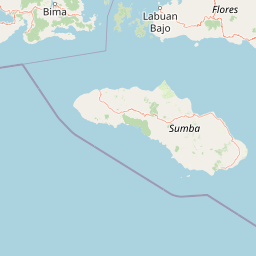
Map view of Komodo National Park

Use this park location map to pinpoint Komodo National Park in Indonesia, understand its exact geographic position, and read its mapped placement within the surrounding landscape more clearly.

Pigeon | © OpenStreetMap contributors

Location context for Komodo National Park

East Nusa TenggaraLesser Sunda IslandsWest Nusa Tenggara
Park atlas

Trace the regional park geography and protected landscapes across Indonesia's Lesser Sunda Islands.

Explore Other National Parks and Protected Areas Near Komodo National Park
Expand your park discovery from Komodo National Park by browsing other protected areas and national parks in Indonesia's Lesser Sunda Islands. Compare their diverse volcanic landscapes, marine biodiversity, and unique conservation focuses to deepen your understanding of the region's protected geography.
National parkEast Nusa Tenggara

Manupeu Tanah Daru National Park: National Park Protected Landscape and East Nusa Tenggara Geography

Discover its mapped boundaries and regional atlas context.

Delve into the protected landscape of Manupeu Tanah Daru National Park, a significant national park situated within East Nusa Tenggara. This dedicated page provides detailed geographic context, focusing on the park's mapped boundaries and its contribution to the regional natural landscape. Understand its identity as a protected area and explore its place within the broader atlas of global conservation lands, fostering a deeper appreciation for its distinct geographic characteristics.

Area
879.84 km²
Established
1998
IUCN
II
Relief
Lowland
National parkSumba

Laiwangi Wanggameti National Park: Protected Landscape and Geographic Atlas

Explore the mapped boundaries and regional context of this national park.

Laiwangi Wanggameti National Park serves as a vital protected area within Indonesia's Sumba region. This entry facilitates a deep dive into the park's specific geography, offering insights into its mapped protected boundaries and its contribution to the regional landscape. Users can engage with structured data to understand the park's unique natural identity and its place within a broader atlas of protected lands, focusing on geographic context and landscape characteristics.

Area
470.14 km²
Established
1998
IUCN
II
Scope
Terrestrial
National parkEast Nusa Tenggara

Kelimutu National Park: Volcanic Terrain and Colored Crater Lakes in East Nusa Tenggara

Explore the mapped geography of this unique Indonesian national park.

Kelimutu National Park represents a remarkable protected landscape in East Nusa Tenggara, Indonesia, distinguished by its volcanic origins and the famed three colored lakes of Mount Kelimutu. This national park protects diverse montane forests and offers a unique insight into the region's geological wonders. Its geography features volcanic slopes and the iconic caldera, making it a significant point of interest for atlas-driven exploration of protected natural areas.

Area
50 km²
Established
1992
IUCN
II
Visitors
12.5K annual
National parkSouth Sulawesi

Bantimurung-Bulusaraung National Park: National Park Protected Landscape Identity and Geographic Setting

Mapped boundaries and regional atlas context for this South Sulawesi park.

Bantimurung-Bulusaraung National Park is an important protected area in South Sulawesi, Indonesia, designated as a national park. This entry provides a focused look at its geographic scope, mapped outlines, and the characteristics that define it as a protected landscape. Understanding this park's specific terrain and regional setting is key to appreciating its role within the broader atlas of natural areas and conservation efforts.

Area
437 km²
Established
2004
IUCN
II
Visitors
600K annual
National parkSouth East Sulawesi

Rawa Aopa Watumohai National Park: Geographic Atlas and Protected Landscape Overview

Explore Rawa Aopa Watumohai National Park's mapped boundaries.

Gain a clear understanding of Rawa Aopa Watumohai National Park, a designated national park in South East Sulawesi. This entry offers insight into its protected landscape identity, mapped geographic features, and its specific location within the regional atlas. It serves as a focused point for comprehending the park's protected area context and its contribution to Indonesian natural geography.

Area
1,050 km²
Established
1989
IUCN
II
Relief
Mixed relief
National parkEast Java

Alas Purwo National Park: A Protected Landscape within East Java's Geography

Mapped natural terrain and national park status in East Java.

Delve into the atlas-specific details of Alas Purwo National Park, a key protected area located in the East Java region of Indonesia. This page focuses on its identity as a national park, highlighting its geographic significance and the value of its mapped landscape for structured discovery. Understand the context of this protected land within the broader geography of East Java, contributing to a comprehensive overview of Indonesia's conservation territories.

Area
434.2 km²
Established
1992
IUCN
II
Visitors
14.7K annual
National parkWest Sulawesi

Gandang Dewata National Park: Protected Area Identity and Geographic Context in West Sulawesi

Explore mapped boundaries and regional landscape.

Delve into the protected landscape of Gandang Dewata National Park, a key national park situated in West Sulawesi. This resource offers a detailed geographic perspective, emphasizing its mapped boundaries and its position within the regional atlas. Understand the park's protected-area status and its contribution to the natural geography of Indonesia, serving as a vital point for atlas exploration.

Area
793.42 km²
Established
2016
IUCN
II
Relief
Mountain
National parkEast Java

Meru Betiri National Park: Mapped Protected Landscape in East Java

Discover the terrain and geography of this national park.

Meru Betiri National Park in East Java, Indonesia, offers a rich tapestry of mapped landscapes, from its distinctive sandy beaches and mangrove ecosystems along the southern coast to its interior volcanic highlands and tropical rainforests. This protected area is crucial for understanding the regional geography and the distribution of conservation lands across Java. Explore its topographic diversity and unique ecological settings that define this significant national park.

Area
580 km²
Established
1982
IUCN
II
Visitors
2.5K annual

Common questions about visiting, size, designation, and location context for Komodo National Park

Komodo National Park FAQs for park facts, access, geography, and protected area context
Find quick answers about Komodo National Park, including protected-area facts, park geography, trail and visitor context, and how the park fits into its surrounding country and regional landscape.
MoriAtlas Explorer

Continue Your Protected Areas Search Across the Global Atlas

Deepen your exploration by continuing the structured search for national parks and protected areas worldwide. Utilize the comprehensive filtering capabilities to compare different conservation landscapes and refine your understanding of global park geography. Discover more about the distribution and characteristics of protected natural areas.

Global natural geography
