

Mori Atlas logo
National parkKubah National Park

Discover the mapped boundaries and regional context of this national park within Sarawak.

Kubah National Park National Park: Understanding Its Protected Landscape and Sarawak Geography

(Taman Negara Kubah)

Kubah National Park stands as a significant protected natural area within the expansive geography of Sarawak, Malaysia. This national park is a vital component for understanding the region's conservation landscapes and mapped terrain. As a designated national park, its boundaries contribute to the broader atlas of protected lands in East Malaysia, offering a unique glimpse into the Borneo landscape. Explore the geographic identity and mapped context of Kubah National Park to enhance your understanding of protected areas.

Tropical rainforestPalm diversitySandstone peaksMatang RangeDipterocarp forestHiking trails

Kubah National Park

National park

Park overview

Structured park overview, official facts, and landscape profile for Kubah National Park

Kubah National Park park facts, protected area profile, and essential visitor context
Review the core facts for Kubah National Park, including designation, size, terrain, visitor scale, habitats, and operating context in one park-focused overview.

About Kubah National Park

Kubah National Park represents a significant conservation priority within Sarawak's protected area network, established in 1989 primarily to safeguard its exceptional botanical diversity. The park occupies a strategic position in the Matang Range, a mountainous region that provides habitat for numerous endemic species. Visitors approaching from Kuching can clearly see the three sandstone peaks that give the park its distinctive character: Gunung Serapi, the highest peak; Gunung Selang; and Gunung Sendok. These granite outcrops rise abruptly from the forested landscape and have become an iconic part of the region's visual identity. The park's trail network offers various experiences, from the short 255-meter Palmetum walk to the more demanding 5-kilometer Summit Trail that requires over three hours to complete. The color-coded trail system includes the Rayu and Waterfall paths, providing options for different fitness levels and interests. Adjacent to the main park area, the Matang Family Park offers recreational facilities including picnic areas and riverside access, while the Matang Wildlife Centre focuses on rehabilitation of orangutans and other wildlife for eventual release into the wild.

Quick facts and research context for Kubah National Park

Kubah National Park spans 2,230 hectares in the Matang Range of Sarawak, Malaysia, located about 20 kilometers from Kuching. The park features three distinctive sandstone peaks: Gunung Serapi, Gunung Selang, and Gunung Sendok. It was established in 1989 specifically to protect its exceptional palm diversity, which includes 98 species. The park contains dipterocarp forest as its primary vegetation, with areas of kerangas and scrub forest interspersed throughout. The nearby Matang Wildlife Centre, managed as part of the park complex, rehabilitates orangutans and other wildlife for release into the wild.

Park context

Deeper park guide and search-rich context for Kubah National Park

Kubah National Park history, landscape, wildlife, and travel context
Explore Kubah National Park through its history, landscape character, ecosystems, wildlife, conservation priorities, cultural context, and seasonal travel timing in a structured park guide built for atlas discovery and search intent.

Why Kubah National Park stands out

Kubah National Park is best known for its world-class palm diversity, hosting 98 palm species that make it one of the richest palm habitats on Earth. The park is also recognized for its three striking sandstone peaks that dominate the skyline and provide popular hiking destinations. The contrast between the dense dipterocarp forest and the more open kerangas areas creates a visually diverse landscape. The Summit Trail to Gunung Serapi offers hikers panoramic views over Kuching and the surrounding region, while the Palmetum trail provides an accessible introduction to the park's botanical richness.

Kubah National Park history and protected-area timeline

Kubah National Park was formally gazetted in 1989, with the protection of its exceptional palm diversity serving as the primary rationale for its establishment. The park's creation reflected growing recognition in Malaysia of the need to preserve unique ecological areas with exceptional biodiversity value. The peak of visitor usage occurred during the Visit Malaysia Year campaign in 1994, when more than 45,000 local visitors were recorded, representing the highest annual visitation in the park's history. Following this peak, visitor numbers declined significantly and remained below 10,000 annually for many years. In recent years, the park has begun attracting more international visitors, though foreign tourist numbers remain modest compared to other Sarawak protected areas. The management of the park falls under the Sarawak Forestry Corporation, which oversees conservation activities and visitor services.

Kubah National Park landscape and geographic character

The landscape of Kubah National Park is defined by its position within the Matang Range and the presence of three prominent sandstone peaks that create a distinctive skyline. Gunung Serapi rises as the most prominent peak, hosting a telecommunications tower at its summit and serving as the destination for the park's most popular hiking trail. The underlying geology consists of ancient granitic formations that have produced the steep-sided peaks and surrounding undulating terrain. The forest types transition across the park's elevation gradient, with dense dipterocarp forest dominating the lower slopes and valley bottoms, while kerangas heath forest occurs on more acidic, nutrient-poor soils. Scrub forest patches are interspersed throughout, particularly in areas affected by past disturbances. The combination of steep terrain, forest cover, and the three visible peaks creates a park with strong visual identity and diverse hiking opportunities.

Kubah National Park ecosystems, habitats, and plant life

The botanical richness of Kubah National Park makes it ecologically significant on a global scale. With 98 documented palm species, the park ranks among the world's richest palm habitats, a diversity that reflects the variety of forest types and microhabitats present within its boundaries. Beyond palms, the mixed dipterocarp and kerangas forests support a wide array of plant life, including numerous Ficus species and their associated fauna. The kerangas forest type, characterized by stunted trees on nutrient-poor sandy soils, adds ecological diversity and supports plant species adapted to these challenging conditions. The transition between forest types creates ecological gradients that increase overall biodiversity. The park's botanical significance extends beyond simple species counts, representing a living repository of tropical forest biodiversity in a relatively accessible location near Kuching.

Kubah National Park wildlife and species highlights

While Kubah is primarily celebrated for its botanical diversity, the park supports a range of animal species across multiple taxa. The mammal community includes bearded pigs, squirrels, and mouse deer, with the nearby Matang Wildlife Centre providing sanctuary for orangutans undergoing rehabilitation. Birdlife is represented by species including hornbills and the colorful fairy pitta, while the park's diverse amphibian population includes the Bornean narrow-mouthed frog. Reptiles and invertebrates also inhabit the park, with the area serving as a locality for several species first described from here, including the stick insect Acacus braggi, which is known only from Gunung Serapi. The rufous-winged fulvetta represents another bird species recorded within the park. This faunal diversity, while less documented than the botanical richness, contributes to the park's overall ecological significance.

Kubah National Park conservation status and protection priorities

Kubah National Park was established specifically to protect its outstanding palm diversity, representing a conservation designation driven by botanical significance. The 98 palm species recorded within the park constitute one of the highest concentrations of palm biodiversity anywhere in the world, justifying protection as a national park. The presence of multiple forest types within a relatively compact area adds conservation value, preserving ecological gradients and habitat diversity. The integration of the Matang Wildlife Centre into the park complex extends conservation efforts to include wildlife rehabilitation, particularly for orangutans. The park's proximity to Kuching makes it accessible for conservation education and research opportunities, while the hiking trails provide visitors with direct experience of the forest ecosystem, potentially building appreciation for conservation needs.

Kubah National Park cultural meaning and human context

Kubah National Park does not contain significant documented cultural heritage sites or traditional indigenous land use areas within its boundaries. The park's establishment in 1989 reflects modern conservation priorities rather than historical cultural relationships with the landscape. The Malay name Taman Negara Kubah represents the official designation in the national language, while the park's management under the Sarawak Forestry Corporation reflects contemporary protected area governance structures.

Top sights and standout views in Kubah National Park

Kubah National Park's three sandstone peaks rising above the forest create a striking visual signature visible from Kuching, with Gunung Serapi offering a challenging summit hike with panoramic views. The Palmetum trail provides an accessible introduction to the park's botanical significance, showcasing the exceptional palm diversity that makes this protected area globally important. The Waterfall trail offers a more leisurely walking experience through forest to a scenic water feature. The park's proximity to Kuching makes it a convenient day trip for visitors wanting to experience Sarawak's forest ecosystems without extensive travel. The adjacent Matang Wildlife Centre adds the opportunity to observe orangutans in a rehabilitation setting.

Best time to visit Kubah National Park

Kubah National Park can be visited year-round given its location in the tropical climate of Sarawak. The dry season, typically from March through October, generally offers more comfortable conditions for hiking, with reduced rainfall and clearer views from the summit peaks. The wet season from November to February brings more frequent rainfall, which can make trail conditions more challenging but also brings the forest to life with waterfall flows at their peak. The cooler early morning hours are ideal for hiking the Summit Trail, allowing hikers to reach the peak before midday heat and potentially enjoy clear views when the air is still. Visitors interested in wildlife viewing may find the early morning and late afternoon periods most productive.

Park location guide

Geography guide, regional context, and park location map for Kubah National Park

Kubah National Park park geography, regions, and map view in Malaysia
Understand where Kubah National Park sits in Malaysia through a broader geographic reading of the surrounding landscape, nearby location context, and its mapped position within the national park landscape.

How Kubah National Park fits into Malaysia

Malaysia is a federal constitutional monarchy located in Southeast Asia. The country consists of 13 states and three federal territories, divided by the South China Sea into Peninsular Malaysia on the Indochinese Peninsula and East Malaysia on the island of Borneo. With a population of over 34 million, it achieved independence from Britain in 1957 and became a modern federation in 1963. The country is recognized for its multicultural population, tropical climate, and significant economic role in the region.

Wider geography shaping Kubah National Park in Malaysia

Malaysia occupies a strategic position in Southeast Asia, split by the South China Sea into two distinct regions. Peninsular Malaysia lies on the Indochinese Peninsula, sharing a land border with Thailand to the north and maritime borders with Singapore, Vietnam, and Indonesia. East Malaysia occupies the northern portion of Borneo, sharing land borders with Brunei and Indonesia, and maritime borders with the Philippines and Vietnam. The country's terrain includes coastal plains, mountain ranges such as the Titiwangsa in the peninsula, and extensive tropical rainforests.

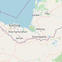
Map view of Kubah National Park

Use this park location map to pinpoint Kubah National Park in Malaysia, understand its exact geographic position, and read its mapped placement within the surrounding landscape more clearly.

Pigeon | © OpenStreetMap contributors

Location context for Kubah National Park

Sarawak
Park atlas

Compare Kubah National Park with other protected landscapes, tracing regional geography and conservation efforts across Sarawak, Malaysia.

Explore Nearby National Parks and Protected Areas around Kubah National Park
After exploring Kubah National Park's unique palm diversity and sandstone peaks, broaden your protected-area discovery by browsing other national parks in the surrounding Matang Range and wider Sarawak region. Compare varied landscapes, forest types, and conservation priorities across mapped park geography, expanding your understanding of Borneo's natural heritage.
National parkSarawak

Kuching Wetlands National Park: Sarawak's Protected National Park Landscape and Geography

Explore the mapped wetland boundaries and regional context.

Gain a structured understanding of Kuching Wetlands National Park, a key protected area in Sarawak, Malaysia. This detailed entry provides insights into its specific geographic identity, mapped park boundaries, and its significance as a national park within the Borneo region's extensive natural landscapes. Discover the atlas value of this protected wetland environment for comprehensive geographic exploration.

Area
84.95 km²
Established
1992
IUCN
II
Relief
Lowland
National parkSarawak

Talang Satang National Park: Protected Landscape and Sarawak Geography

Explore its mapped boundaries and regional context.

Delve into the protected landscape of Talang Satang National Park, a key national park situated in the dynamic geography of Sarawak, Malaysia. This entry provides essential context for understanding its specific protected boundaries and its contribution to the broader regional natural landscape. Discover its atlas-relevant details to enrich your understanding of Borneo's protected areas and their geographic distribution.

Area
194.14 km²
Established
1999
IUCN
II
Relief
Lowland
National parkSarawak

Santubong National Park: Sarawak's Protected Landscape for Geographic Atlas Exploration

Mapped park boundaries and regional terrain context in Borneo

Delve into Santubong National Park, a significant protected area situated within the diverse geography of Sarawak, Malaysia. This resource provides detailed information on the park's mapped boundaries, allowing for focused exploration of its specific terrain and its role within the regional protected landscape atlas. Understand the geographic identity of Santubong National Park and its contribution to Borneo's conservation mapping.

Area
14.1 km²
Established
2007
IUCN
II
Relief
Mountain
Watercolor illustration of a coastal landscape with a distinctive rock formation, green vegetation, and calm water under a soft sky with distant mountains
National parkKuching Division

Bako National Park: Sarawak's Oldest National Park and Coastal Protected Landscape

Explore diverse ecosystems and dramatic mapped geology near Kuching Division.

Bako National Park, the oldest national park in Sarawak, Malaysia, offers a profound study in ecological concentration and geological drama. Covering a mere 27 square kilometers on the Muara Tebas peninsula, it encapsulates seven distinct ecosystem types, from coastal heath forest to mangrove areas, supporting significant biodiversity. The park's protected landscape is defined by its stunning sandstone coastline, carved by the sea into cliffs, arches, and seastacks, providing a unique geographic context. This makes Bako an essential destination for understanding Borneo's environmental diversity and the mapped boundaries of its conservation areas.

Area
27.27 km²
Established
1957
IUCN
II
Relief
Mixed relief
National parkSarawak

Gunung Gading National Park: Sarawak's Protected Landscape and Geographic Context

Discover mapped terrain and protected area boundaries.

Gunung Gading National Park is an important national park located in Sarawak, Malaysia, offering critical insights into the region's geography and protected lands. This park serves as a key entity for exploring its specific mapped terrain and understanding its place within the diverse landscapes of Borneo. Examining Gunung Gading National Park aids in comprehending the distribution and character of protected areas in East Malaysia through a structured, atlas-oriented approach.

Area
43.6 km²
Established
1983
IUCN
II
Relief
Mountain
National parkKuching Division

Tanjung Datu National Park: Protected Landscape and Regional Geography

Explore its mapped boundaries within Kuching Division.

Tanjung Datu National Park is a protected natural area offering insight into regional conservation and geographic patterns within Malaysia. This entry provides a detailed look at the park's identity as a national park, focusing on its mapped boundaries and its contribution to the broader landscape context of the Kuching Division. It is designed for users seeking structured information about protected areas and their geographical distribution.

Area
7.3 km²
Established
1994
IUCN
II
Climate
Tropical
National parkMalaysia

Maludam National Park: Southeast Asian Protected Landscape and National Park Geography

Mapped boundaries and natural terrain in Malaysia.

Maludam National Park offers a focused exploration of protected landscape identity and geographic context within Malaysia. As a designated national park, it serves as a vital component for understanding the distribution of protected areas and their mapped terrain. This detailed entry allows for an appreciation of the park's specific environmental character and its contribution to the broader atlas of natural landscapes in Southeast Asia, facilitating structured discovery for researchers and explorers.

Area
432 km²
Established
2000
IUCN
II
Relief
Lowland
National parkSarawak

Rajang Mangroves National Park: Borneo's Premier Mangrove Protected Landscape

Explore the mapped geography and wetland conservation of this Sarawak national park.

Rajang Mangroves National Park is a significant protected area dedicated to preserving the intricate mangrove swamp ecosystems of Sarawak's Rajang River delta. Encompassing a vast expanse of tidal channels and riverine forests, this national park serves as a critical habitat for unique wildlife and plays a vital role in coastal ecological health. Its landscape is defined by the dynamic interface between riverine and marine environments, offering a prime example of wetland conservation within Borneo's broader natural geography and atlas context.

Area
107 km²
Established
2000
IUCN
II
Relief
Lowland

Common questions about visiting, size, designation, and location context for Kubah National Park

Kubah National Park FAQs for park facts, access, geography, and protected area context
Find quick answers about Kubah National Park, including protected-area facts, park geography, trail and visitor context, and how the park fits into its surrounding country and regional landscape.
MoriAtlas Explorer

Continue Your Protected Areas Search Across the Global Atlas

Deepen your exploration by continuing the structured search for national parks and protected areas worldwide. Utilize the comprehensive filtering capabilities to compare different conservation landscapes and refine your understanding of global park geography. Discover more about the distribution and characteristics of protected natural areas.

Global natural geography