
Rivers
Park geography
A structured examination of regional landscapes, physical features, and area measurements
La Mauricie National Park: Detailed Geographic Profile, Mapped Boundaries, and Terrain Analysis
Review the precise geographic scope of La Mauricie National Park, situated in the province of Quebec. This profile provides data on boundary-derived measurements, elevation variations ranging from 150 to 500 meters, and a diverse catalog of natural features including boreal forests, lakes, and mountain plateaus.
Related tags
national parkboreal forestmixed forestlake networkprotected area
Quebec's boreal wilderness of 150 lakes and dense mixed forests
La Mauricie National Park
La Mauricie National Park is a protected wilderness area in Quebec, Canada, situated within the Laurentian Mountains of the Mauricie region. The park encompasses 536 square kilometres of southern Canadian Shield terrain, characterized by a gently rolling plateau that slopes from approximately 150 metres elevation near the Saint-Maurice River to nearly 500 metres inland. This landscape is defined by an extensive network of about 150 lakes, wetlands, and streams that drain into the Saint-Maurice River system. The park lies within the Eastern forest-boreal transition ecoregion, where dense mixed forests of conifers and deciduous trees now cover 93 percent of the territory. Established in 1970 through a federal-provincial agreement, La Mauricie is managed by Parks Canada and receives approximately 280,000 visitors annually, making it a significant destination for outdoor recreation in Quebec while serving as an important ecological sanctuary for boreal and temperate forest species.
- Location
- Canada
- Park type
- National park
- Established
- 1970
- Area
- 536 km²
Location overview
Continental placement and regional territory within Quebec
National Park Geography: La Mauricie National Park in Canada
La Mauricie National Park is located entirely within the province of Quebec in Canada. The inland protected area maintains a non-transboundary status with no coastal, island, or marine designations.
- Countries
- Canada
- Regions
- Quebec
- Primary location
- Quebec
- Geographic setting
- Inland
Boundary and coordinates
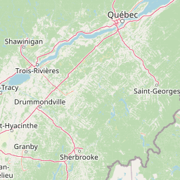
Interactive boundary geometry and recorded area measurements
La Mauricie National Park Boundary Map and Spatial Extent
Mapped park geometry establishes clear spatial context for the protected area. Accompanying measurements detail the recorded area, coordinate limits, geographic span, and central position.
- Boundary area
- 536.9 km²
- Boundary perimeter
- 142.2 km
- Northernmost point
- 46.9195° N
- Southernmost point
- 46.6465° N
- Easternmost point
- 72.7652° W
- Westernmost point
- 73.179° W
- Geographic centre
- 46.7877° N, 72.9659° W
- North–south span
- 30.3 km
- East–west span
- 31.6 km
Elevation and terrain
Track mountain relief metrics and recorded interior water bodies
La Mauricie National Park Elevation Range and Mountain Terrain Geography
Recorded park elevations span from one hundred fifty meters to five hundred meters across mountain terrain. Associated cards detail internal rivers, lakes, viewpoints, and waterfalls located within boundaries.
- Minimum elevation
- 150 m
- Maximum elevation
- 500 m
Selected named natural features
Lakes
Lac Cutaway
Lakes
Lac Soumire
Lakes
Lac Besace
Lakes
Lac Valby
Lakes
Lac Archange
Environmental setting
Boreal climate zones, dominant forest cover, and major water presence
La Mauricie National Park Environmental Classifications and Physical Settings
Recorded landscape features and habitat types serve as complementary frameworks for reading physical settings. Stored classifications connect directly to relevant regional atlas destinations where available.
- Relief
- Mountain
- Climate
- Boreal
- Water
- Major water bodies
- Forest cover
- Dense forest cover
- Seasonality
- Seasonal
Landscape features
Mountains · Valleys · Plateau · Cliffs · Forest · Wetland · Bog · Lakes · Rivers · Cave · Islands · Glacier
Habitat types
Boreal forest · Temperate broadleaf forest · Temperate coniferous forest · Wetland · Peatland · Riverine habitat · Lacustrine habitat · Glacial habitat
Park atlas
Explore Quebec's vast protected landscapes, from the Canadian Shield terrain to diverse forest regions
Discover Other National Parks and Protected Areas Near La Mauricie National Park, Quebec
Continue your discovery journey from La Mauricie National Park by exploring other national parks and protected areas across Quebec and its rich Canadian Shield geography. Compare varied conservation zones, trace regional park networks, and uncover additional boreal forest reserves within a comprehensive geographic context.
Wildlife reserveQuebec
About 89 km away#1 closest
South

Réserve nationale de faune des îles de Contrecœur: Mapped Wildlife Reserve and Wetland Habitat
Protected freshwater ecosystems in the St. Lawrence River, Quebec
Discover the geographic footprint of the Réserve nationale de faune des îles de Contrecœur, a protected network of islands and channels in the St. Lawrence River. This entry provides context on the reserve's role in conserving emergent aquatic vegetation and waterfowl nesting sites within the broader southern Quebec landscape.
- Area
- 3.12 km²
- Established
- 1981
- IUCN
- Ia
- Relief
- Lowland
Nature reserveQuebec
154 km away#2 closest
Southwest
Îles de la Paix Migratory Bird Sanctuary: Protected Island Geography and Wetland Maps
A vital riverine habitat within the St. Lawrence River basin
Examine the unique river-island topography of the Îles de la Paix Migratory Bird Sanctuary in Quebec. This protected area offers a rare glimpse into a dynamic landscape of marshes and flooded forests, serving as a critical node in the St. Lawrence River migratory flyway near the Montreal metropolitan region.
- Area
- 10.92 km²
- Established
- 1972
- IUCN
- III
- Relief
- Lowland

Wildlife reserveQuebec
About 160 km away#3 closest
Southwest
Réserve nationale de faune des îles de la Paix: Geography of an Island Wetland Refuge
A protected wildlife corridor in southwestern Quebec
The Réserve nationale de faune des îles de la Paix comprises a cluster of islands and protected wetlands in the St. Lawrence River. This site provides critical nesting and staging grounds within a managed habitat system, connecting forested terrestrial areas with expansive aquatic zones essential for migratory bird species.
- Area
- 1.87 km²
- Established
- 1977
- IUCN
- Ia
- Relief
- Lowland
Wildlife reserveQuebec
About 214 km away#4 closest
Southwest
Réserve nationale de faune du lac-Saint-François: A Protected Wetland Landscape in Quebec
Explore wildlife reserve boundaries, riparian habitats, and St. Lawrence River geography.
This protected area safeguards a diverse freshwater wetland complex along the St. Lawrence River. Covering marshes, cedar stands, and mixed hardwood forests, the reserve provides a critical sanctuary for migratory species. The geography of the site offers a unique look at transition zones between open water and inland plains, serving as a key node for bird conservation in Quebec.
- Area
- 15.21 km²
- Established
- 1978
- IUCN
- III
- Relief
- Lowland
Protected landscapeNew Hampshire
250 km away#5 closest
Southeast

White Mountain National Forest: Protected Landscape Atlas and Geographic Boundary Context
Mapping the alpine ridges and river valleys of New Hampshire
Delve into the geography of White Mountain National Forest, a primary federal protected landscape in the eastern United States. This overview details the mountainous terrain, including the Presidential Range and Pemigewasset Wilderness, providing a clear window into its spatial scale, watershed boundaries, and regional prominence within the New England landscape.
- Area
- 3,038.59 km²
- Established
- 1918
- Relief
- Mountain
- Climate
- Temperate
Wildlife reserveQuebec
About 263 km away#6 closest
Northeast
Réserve nationale de faune des îles de l'Estuaire: Wildlife Reserve and Estuary Geography
Mapped protected island chain in the Quebec St. Lawrence Estuary.
This wildlife reserve encompasses a chain of small islands that provide predator-free nesting sites for seabirds and waterbirds. Situated along the St. Lawrence Estuary, the area acts as a critical link for regional conservation, supporting seals and marine life within a unique sedimentary landscape.
- Area
- 4.04 km²
- Established
- 1986
- IUCN
- Ia
- Relief
- Lowland

Protected landscapeVermont
276 km away#7 closest
South
Green Mountain National Forest: Mapped Geography and Protected Landscape Analysis
Examining the wilderness backbone of Vermont's mountainous terrain
Gain insight into the expansive boundaries of Green Mountain National Forest, an essential protected area spanning the Green Mountains of Vermont. This profile details the forest's composition, ranging from high-elevation spruce-fir zones to mixed hardwood slopes and extensive federal wilderness corridors, providing a foundational geographic understanding of this vital northeastern landscape.
- Area
- 1,615.31 km²
- Established
- 1932
- Relief
- Mountain
- Climate
- Temperate
Wildlife reserveQuebec
287 km away#8 closest
Northeast
Zugvogelschutzgebiet L’Isle-Verte Wildlife Reserve: Coastal Marsh and St. Lawrence Estuary Geography
Protected wetland boundaries and estuarine landscape in Quebec, Canada
Discover the geographic layout of Zugvogelschutzgebiet L’Isle-Verte, a specialized wildlife reserve in Quebec. This protected area centers on a productive tidal marsh system along the St. Lawrence Estuary, serving as an internationally recognized site for migratory waterfowl and shorebirds. The map-focused overview highlights the unique coastal terrain and the ecological significance of this narrow but vital strip of protected land.
- Area
- 3.76 km²
- Established
- 1986
- IUCN
- IV
- Relief
- Lowland
MoriAtlas Explorer
Continue Exploring La Mauricie National Park's Mapped Landscape and Regional Geography
Deepen your understanding of La Mauricie National Park by exploring its specific geographic context and protected land attributes. This resource supports a factual discovery of the park's landscape character and its role within Quebec's atlas. Investigate the mapped terrain and boundaries to gain a comprehensive view of this significant national park's place in the natural world, beyond mere visitor information.
Browse next
Global natural geography
Explore related park routes
Explore MoriAtlas Global ParksBrowse All MoriAtlas ParksGlobal Park Map DiscoveryMoriAtlas: Browse All CountriesBrowse All MoriAtlas ContinentsNational Park Environment AtlasGrand Canyon National Park AtlasYellowstone National Park AtlasYosemite National Park Atlas and GeographySerengeti National Park AtlasGalápagos National Park Protected LandscapeBanff National Park Geography and AtlasKruger National Park Atlas EntryUluṟu-Kata Tjuṯa National Park AtlasExplore Uluru-Kata Tjuta National Park GeographyPlitvice Lakes National Park AtlasFiordland National Park Protected LandscapeGreat Smoky Mountains National Park AtlasAfghanistan National Parks and Protected AreasAlbania National Parks and Protected AreasAlgeria National Parks and Protected AreasAmerican Samoa National Parks and Protected AreasAndorra National Parks and Protected AreasAngola National Parks and Protected AreasAntarctica National Parks and Protected AreasAntigua and Barbuda Park List