

Mori Atlas logo
Nature reserveLa Mesa Watershed Reservation

A critical forest ecosystem and freshwater reservoir serving the Philippine capital region.

La Mesa Watershed Reservation: Mapping the Essential Protected Nature Reserve of Metro Manila

La Mesa Watershed Reservation protects a significant block of lowland rainforest within the dense urban fabric of Metro Manila. This nature reserve, centered on the La Mesa Dam and Reservoir, acts as a primary hydrological anchor for the capital region, safeguarding water supplies for millions while maintaining diverse habitats ranging from closed-canopy forest to swampforest margins. Its unique geographic position at the base of the Sierra Madre provides a vital ecological link between the urban metropolis and the surrounding Luzon terrain.

watershedurban watershedlowland rainforestMega Manilafreshwater reservoirswampforest
An illustrative art piece showing a town tucked into a valley, overlooking a lake or reservoir with a distant waterfall and rolling hills under a soft sun.

La Mesa Watershed Reservation

Nature reserve

Park overview

Structured park overview, official facts, and landscape profile for La Mesa Watershed Reservation

La Mesa Watershed Reservation park facts, protected area profile, and essential visitor context

Review the core facts for La Mesa Watershed Reservation, including designation, size, terrain, visitor scale, habitats, and operating context in one park-focused overview.

About La Mesa Watershed Reservation

La Mesa Watershed Reservation is a protected rainforest and water catchment that defines both the ecology and the domestic water supply of Metro Manila. It lies on a flat-topped mesa at the southern foot of the Sierra Madre mountain range, occupying the northernmost sections of Quezon City together with parts of Caloocan and Rodriguez, Rizal. The reservation is roughly 9 kilometers north of central Quezon City and about 20 kilometers northeast of Rizal Park in Manila, placing a substantial forested block directly inside one of the most heavily urbanized regions in Southeast Asia.

At the heart of the reservation is the La Mesa Dam and Reservoir, a 700-hectare artificial lake created in 1929 during the American colonial period as part of the Ipo-Novaliches-San Juan water system for Manila. The reservoir continues to function as a primary source of potable drinking water for approximately 12 million residents of the metropolitan area, a responsibility that shapes both the forest management regime and the conservation priority of the surrounding watershed. The 2,000-hectare forest encircling the lake is widely described as the green lung of Metro Manila, helping to moderate air quality and microclimate while providing more than 50 kilometers of nature trails for visitors.

Beyond the reservoir, the watershed supports a mosaic of habitats, including closed-canopy lowland rainforest, secondary growth, open clearings and pastures, swampforest along the muddy reservoir fringe, and patches of reed and other swamp vegetation. Within the southern edges of the reservation, the La Mesa Eco Park provides a managed public-access area on about 33 hectares, with the larger forest landscape reserved under a more protective regime. The Tullahan River originates inside the watershed and flows through Malabon and Navotas before reaching Manila Bay, giving the protected area significance beyond internal catchment boundaries.

La Mesa's identity is unusual for a protected area in the Philippines: it functions simultaneously as a water supply reservoir, a remnant lowland rainforest, an urban biodiversity refuge, and a heavily visited recreational site. That combination is what gives the watershed its strategic importance and also what makes its preservation a constant balance between ecological protection, urban development pressure, and public use.

Quick facts and research context for La Mesa Watershed Reservation

La Mesa Watershed Reservation is the only major watershed in Metro Manila and surrounds the La Mesa Dam and Reservoir, a 700-hectare artificial lake built in 1929 under American colonial rule. The protected area covers roughly 2,659 hectares across Quezon City, Caloocan, and Rodriguez, Rizal, most of which lies on a flat-topped mesa reaching about 250 meters above sea level at its northern edge.

About 1,800 hectares remain under forest cover, supporting more than 50 kilometers of nature trails, swampforest along the reservoir margin, and a 33-hectare ecological park known as La Mesa Eco Park. It was formally established as a protected area in 2007 through Presidential Proclamation No. 1336, and it remains jointly supervised by the Department of Environment and Natural Resources and the Metropolitan Waterworks and Sewerage System.

Protection and recognition

Documented terrestrial protection scope, management framework, and conservation recognition details.

La Mesa Watershed Reservation Protection Status and Designation Records

Terrestrial protection status, management scope, and documented designation records for La Mesa Watershed Reservation are compiled within this structured overview. Conservation frameworks and international recognition histories remain accessible for analytical evaluation and geographic research.

Protection details

Protection scope
Terrestrial
Transboundary protection
No
Park context

Deeper park guide and search-rich context for La Mesa Watershed Reservation

La Mesa Watershed Reservation history, landscape, wildlife, and travel context

Explore La Mesa Watershed Reservation through its history, landscape character, ecosystems, wildlife, conservation priorities, cultural context, and seasonal travel timing in a structured park guide built for atlas discovery and search intent.

Why La Mesa Watershed Reservation stands out

La Mesa is best known as the last significant lowland rainforest inside Metro Manila and as the drinking-water lifeline for around 12 million people in the metropolitan area. The watershed's 2,000-hectare forest ring around the reservoir is widely recognized as an ecological counterweight to one of the most densely populated regions on earth. The area is also notable among birdwatchers and local naturalists as an accessible birding site where species such as the spotted wood kingfisher, Philippine pygmy woodpecker, and black-naped oriole can still be observed within an hour of central Manila. The Tullahan River, which flows from the watershed through Malabon and Navotas into Manila Bay, adds hydrological significance beyond the reservoir itself.
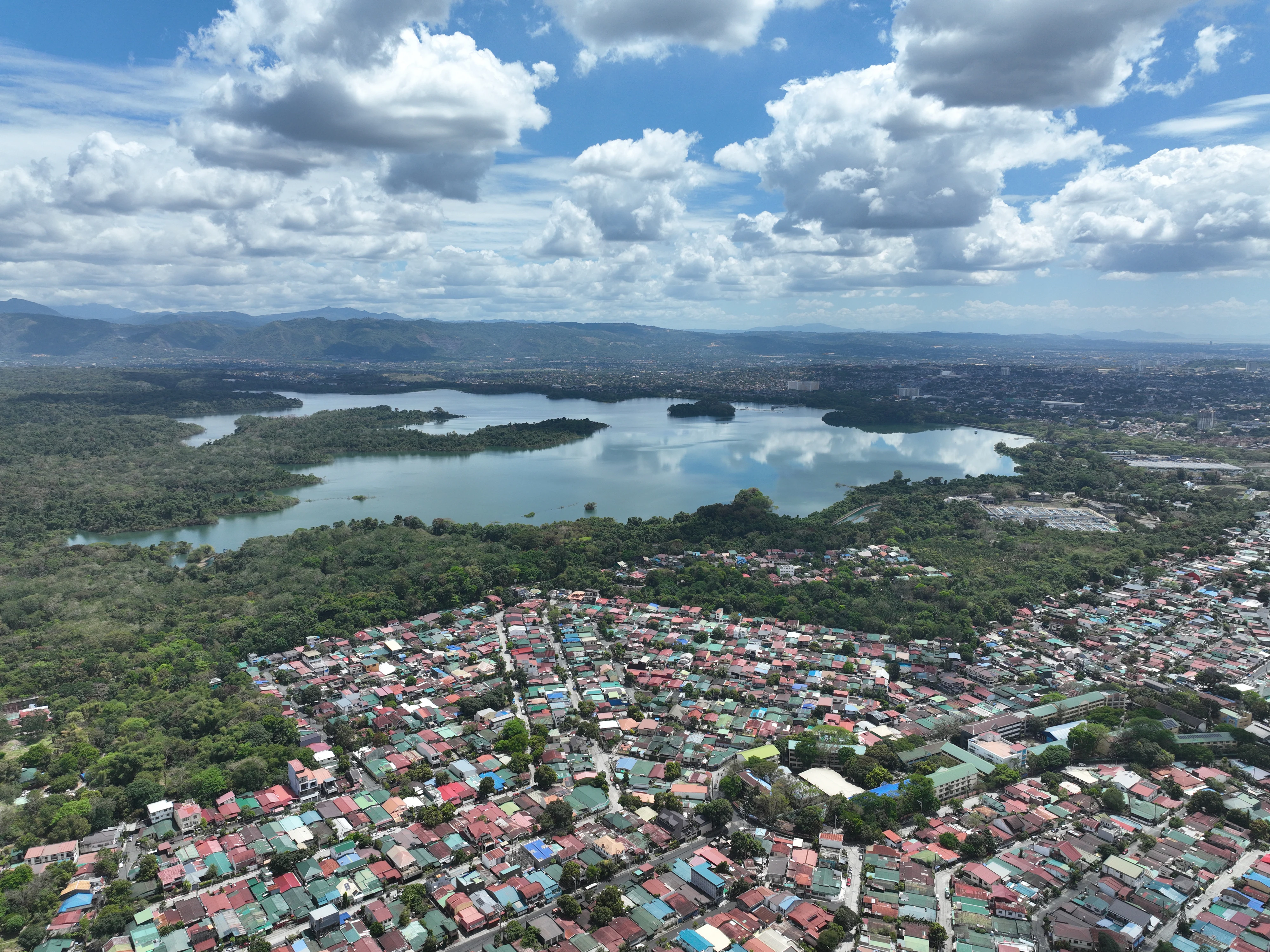
Aerial drone shot looking down at the large body of the La Mesa Dam reservoir surrounded by dense forest, bordered by a dense residential neighborhood in the foreground under a cloudy blue sky.
Aerial view of the La Mesa Dam and surrounding forest reservation in Quezon City.

La Mesa Watershed Reservation history and protected-area timeline

The hydrological infrastructure at the heart of La Mesa was first developed in 1929, when the La Mesa Dam and Reservoir was constructed under the American colonial government as part of Manila's Ipo-Novaliches-San Juan water system. The artificial lake became a central element of the capital's expanding water network, supplying a growing urban population from the forested uplands north of the city.

Early reforestation efforts began in the late 1970s, when the Manila Seedling Bank conducted a five-year program from 1978 to 1983 aimed at restoring forest cover on the mesa and stabilizing the catchment. By the early 2000s the area had evolved into a managed mosaic of forest, reservoir, recreational facilities, and an ecological park, with the 33-hectare La Mesa Eco Park opening in 2003 under the Quezon City government.

Formal protected-area status came on July 25, 2007, when President Gloria Macapagal Arroyo issued Proclamation No. 1336 establishing the La Mesa Watershed Reservation. The reservation was placed under the joint supervision of the Department of Environment and Natural Resources and the Metropolitan Waterworks and Sewerage System, cementing its dual role as a drinking-water catchment and a legally protected forest reserve. In later years concerns over encroachment, informal settlement, and unauthorized land conversion led to interventions by former Environment Secretary Gina Lopez, including the cancellation of an environmental compliance certificate tied to a disputed housing development in late 2016.

La Mesa Watershed Reservation landscape and geographic character

La Mesa sits on a flat-topped hill or mesa that rises above the surrounding lowlands of Metro Manila, with its highest point reaching about 250 meters above sea level at the northern tip within Quezon City. From this elevated plateau, the terrain drops toward the Marikina Valley and the southern flanks of the Sierra Madre, giving the watershed a setting that is visually distinct from the densely built-up neighborhoods of Quezon City, Caloocan, and Manila that lie to its south and west.

The central landform is the 700-hectare La Mesa Reservoir, an artificial lake that dominates the catchment. Its margins include exposed mudflats, swampforest, and reed-filled shallows, producing an abrupt transition between open water, wet-edge vegetation, and closed-canopy forest. The encircling 2,000 hectares of forest form a continuous green ring around the lake, broken occasionally by open clearings, pastures, and areas used for tree nurseries and reforestation work, including the Million Trees Nursery and Eco Learning Center.

To the south and east the watershed's slopes blend into the urban fabric, particularly through the East Fairview area of Quezon City where the La Mesa Eco Park provides a managed green interface with the city. From the watershed's edge, the Tullahan River runs westward through Malabon and Navotas before emptying into Manila Bay, linking the protected forest and reservoir to the broader coastal hydrological system.

La Mesa Watershed Reservation ecosystems, habitats, and plant life

The watershed protects the last significant block of Luzon rainforest remaining inside Metro Manila, a lowland evergreen forest type that has largely disappeared elsewhere from the metropolitan region. Forest cover extends across roughly 1,800 hectares of the reservation, while the remaining area consists of open clearings, pastures, cultivation sites, water surfaces, and the 33-hectare La Mesa Eco Park.

Ecological conditions are unusually varied for such a small protected area. Closed-canopy forest dominates the higher slopes, while the reservoir margin transitions into swampforest, reedbeds, and exposed mudflats. The combination of forest interior, regenerating secondary growth, wet-edge habitats, and open patches creates a mosaic that supports both forest-dependent and wetland-associated species within a few hundred meters of each other.

La Mesa Watershed Reservation wildlife and species highlights

The reservation serves as an important breeding area for resident and migrant wildlife, particularly birds. Recorded species include little heron, black-crowned night heron, osprey, Japanese sparrowhawk, plain bush-hen, common moorhen, Eurasian coot, Philippine coucal, Philippine nightjar, island swiftlet, spotted wood kingfisher, common kingfisher, white-collared kingfisher, Philippine pygmy woodpecker, barn swallow, pied triller, ashy minivet, Philippine bulbul, black-naped oriole, Oriental magpie robin, Arctic warbler, grey-streaked flycatcher, pied fantail, yellow-bellied whistler, grey wagtail, brown shrike, olive-backed sunbird, and lowland white-eye.

The combination of resident lowland forest species, wetland birds along the reservoir margins, and migratory visitors such as the Japanese sparrowhawk and Arctic warbler makes the watershed a key inland bird site for Metro Manila. Forest tree composition is dominated by Malay beechwood, earleaf acacia, Acacia mangium, narra, mahogany, teak, ipil-ipil, alibangbang, and bangkal, reflecting a mix of native and reforestation-origin species.

La Mesa Watershed Reservation conservation status and protection priorities

La Mesa's conservation importance lies in its dual function as a water-supply catchment for about 12 million residents and as the last major surviving block of lowland rainforest inside Metro Manila. The forest not only stabilizes the hydrology around the reservoir but also provides air-quality and climate buffering for one of the most densely populated regions in the world.

Ongoing threats include land conversion, deforestation from illegal harvesting, slash-and-burn cultivation by informal settler families, and encroachment tied to urban expansion. A 2013 vulnerability assessment identified parts of the watershed as prone to erosion and landslide, highlighting the fragility of the slopes despite their protected status. Conservation oversight is shared between the Department of Environment and Natural Resources and the Metropolitan Waterworks and Sewerage System, while historical reforestation efforts trace back to the Manila Seedling Bank's 1978-1983 program and continue through facilities such as the Million Trees Nursery.

La Mesa Watershed Reservation cultural meaning and human context

The watershed is closely woven into the daily life of Metro Manila through its role in supplying drinking water to roughly 12 million residents. The Tullahan River, which originates in the reservation and flows through Malabon and Navotas into Manila Bay, has long served as a hydrological thread linking the upland forest to coastal communities, including low-lying and flood-prone neighborhoods downstream.

The reservation also carries layers of metropolitan recreation and education, with more than 50 kilometers of nature trails, a 33-hectare public ecological park at its southern edge, and a reforestation nursery that doubles as an environmental learning site. Together these features position the watershed as both a working landscape and a place of urban green identity for the surrounding cities.

Top sights and standout views in La Mesa Watershed Reservation

The defining features of La Mesa Watershed Reservation are its status as Metro Manila's only major watershed, its population of roughly 12 million water users, and its roughly 2,000 hectares of encircling forest that act as a green lung for the metropolitan region. The reservation's mix of closed-canopy rainforest, reservoir margin swampforest, and open clearings creates habitat diversity unusual for such a heavily urbanized setting.

Equally distinctive is the presence of a thriving lowland bird community, including endemic and migrant species such as the spotted wood kingfisher, Philippine coucal, and Japanese sparrowhawk, observable within easy reach of central Manila. The watershed's role as the source of the Tullahan River and its continued operation as a working water-supply catchment make it a rare example of an ecologically meaningful, functioning urban watershed.

Best time to visit La Mesa Watershed Reservation

La Mesa Watershed Reservation can be visited throughout the year, but the character of a visit shifts with the seasons. The dry months, generally from late December through May, typically offer more comfortable trail conditions, clearer skies, and a greater chance of taking in views over the reservoir and surrounding mesa from the higher elevations of the watershed.

The wetter months, generally running from roughly June through November, bring heavier rainfall, more muddy trail conditions, and occasional access restrictions, but also replenish the reservoir, swell swampforest and reedbed habitats, and can boost bird activity, including migratory visitors and wetland species around the reservoir margins. For visitors focused on birdwatching rather than long-distance views, the wet season's concentration of waterbirds at the reservoir edge can be especially rewarding.

Monthly climate preview

Long-term representative monthly temperature and precipitation rhythm

La Mesa Watershed Reservation Climate Normals and Annual Weather Patterns

La Mesa Watershed Reservation records measured long-term averages for monthly temperature and precipitation across a representative coordinate. Reviewing the complete twelve-month profile provides deeper context on historical weather variations and seasonal shifts.
Annual mean26 °C
23 °C28 °C
Jan23°
Feb24°
Mar25°
Apr27°
May28°
Jun27°
Jul26°
Aug26°
Sep26°
Oct26°
Nov25°
Dec24°
Warmest month
May

27.8 °C

Coolest month
January

23.5 °C

Wettest month
December

12.4 mm/day

Driest month
April

3.3 mm/day

Park location guide

Geography guide, regional context, and park location map for La Mesa Watershed Reservation

La Mesa Watershed Reservation park geography, regions, and map view in Philippines

Understand where La Mesa Watershed Reservation sits in Philippines through a broader geographic reading of the surrounding landscape, nearby location context, and its mapped position within the national park landscape.

How La Mesa Watershed Reservation fits into Philippines

The Philippines, officially the Republic of the Philippines, is an archipelagic nation in Southeast Asia comprising approximately 7,641 islands categorized into three main geographical divisions: Luzon, Visayas, and Mindanao. Located in the western Pacific Ocean, it shares maritime borders with Taiwan, Japan, Palau, Indonesia, Malaysia, Vietnam, and China. Manila serves as the capital city, while Quezon City is the most populated city, both within Metro Manila.

Wider geography shaping La Mesa Watershed Reservation in Philippines

The Philippines is an archipelagic nation in Southeast Asia, positioned in the western Pacific Ocean. Its islands are bounded by the South China Sea to the west, Philippine Sea to the east, and Celebes Sea to the south. The country shares maritime borders with Taiwan to the north, Japan to the northeast, Palau to the east and southeast, Indonesia to the south, Malaysia to the southwest, Vietnam to the west, and China to the northwest.

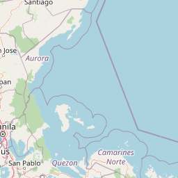
Map view of La Mesa Watershed Reservation

Use this park location map to pinpoint La Mesa Watershed Reservation in Philippines, understand its exact geographic position, and read its mapped placement within the surrounding landscape more clearly.

Pigeon | © OpenStreetMap contributors

Location context for La Mesa Watershed Reservation

Metro Manila

Visualizing the lowland rainforest, reservoir margins, and urban forest habitats of the protected reserve

La Mesa Watershed Reservation Photos, Landscapes, and Protected Scenery

Visual records capture the dense closed canopy forest, open reservoir margins, and distinct terrain features defining the protected reserve. Examining these photographic perspectives reveals the environmental character of the lowland rainforest and freshwater catchment within the metropolitan region.

Aerial drone shot looking down at the large body of the La Mesa Dam reservoir surrounded by dense forest, bordered by a dense residential neighborhood in the foreground under a cloudy blue sky.

A male Spotted wood kingfisher perched on a thin tree branch, showcasing its colorful blue, orange, and spotted plumage against a blurry forest background.

Park atlas

Compare surrounding regional geography and connected conservation landscapes

Other Parks and Protected Areas Near La Mesa Watershed Reservation

Continue exploring other protected areas near La Mesa Watershed Reservation to compare regional forest habitats, freshwater catchments, and lowland ecosystems. Expanding the search across adjacent terrain reveals broader ecological patterns and related natural reserves throughout the surrounding region.
Protected landscapeRizal
About 15 km away#1 closest

Southeast

Upper Marikina River Basin Protected Landscape: Watershed Geography and Sierra Madre Mapping

A critical forest reserve and hydrological basin in Rizal

Covering the upper reaches of the Marikina River, this protected landscape forms a massive forested block within the southern Sierra Madre. The area serves as a primary catchment system, defined by its rugged mountain ridges, descending river corridors, and long-standing role in regional water management. Mapping these protected lands reveals the essential link between mountain ecosystems and downstream hydrological stability.

Area
261.256 km²
Established
1904
IUCN
V
Relief
Mountain
A soft, artistic watercolor painting depicting a winding river flowing through a lush green valley with distant mountain ranges.
Nature reserveBulacan
About 27 km away#2 closest

North

Angat Watershed Forest Reserve: Mountain Watershed Geography and Protected Forest Terrain

A critical nature reserve in the Sierra Madre of Bulacan

This protected area anchors the water supply for Metro Manila while preserving extensive submontane forests and mountain ridges in Central Luzon. The landscape features deep river valleys, hydroelectric reservoirs, and peaks like Mount Oriod that define the local geography of this important conservation zone.

Area
623.09 km²
Established
1927
IUCN
VI
Relief
Mountain
Watercolor illustration depicting a serene wetland scene with soft green marshland, a central body of water, and distant rolling hills.
Protected areaMetro Manila
About 31 km away#3 closest

Southwest

Las Piñas, Parañaque Wetland Park: Protected Coastal Geography in Metro Manila

Mangroves, tidal mudflats, and essential avian migratory corridors.

Discover the geographic layout and protected status of Las Piñas, Parañaque Wetland Park. This coastal refuge provides a rare natural contrast to the dense urbanization of Metro Manila, safeguarding critical mangrove habitats and tidal environments that support diverse migratory bird species.

Area
1.81 km²
Established
2007
Relief
Lowland
Climate
Tropical
National parkBulacan
About 40 km away#4 closest

North

Biak-na-Bato National Park: National Park Atlas and Geographic Context in Bulacan

Explore protected landscapes and mapped terrain.

Biak-na-Bato National Park is a key protected area in Bulacan, Philippines, identified for its national park designation. This entry provides specific details on its geographic positioning and mapped features, essential for atlas-based research and understanding the distribution of protected lands within the region. Dive into the landscape context and mapped boundaries that define this significant natural entity.

Area
21.17 km²
Established
1937
IUCN
V
Relief
Mountain
National parkBataan
About 55 km away#5 closest

West

Bataan National Park: Philippines Protected Landscape and National Park Geography

Mapped boundaries and regional natural landscape context.

This detail entry for Bataan National Park provides essential context for understanding its role as a protected landscape within the Philippines. Users can explore the park's mapped boundaries, its geographic setting in the Bataan region, and its identity as a national park. The focus is on atlas-style discovery, allowing for a deeper appreciation of the park's natural terrain and its place within the country's protected area network.

Area
236.88 km²
Established
1945
IUCN
II
Relief
Mountain
Illustration of a river with bamboo boats, people rowing, limestone cliffs, and trees
National parkNueva Ecija
About 61 km away#6 closest

North

Minalungao National Park: Protected Landscape and Geographic Context in Nueva Ecija

Explore the mapped boundaries of this Philippines national park.

Delve into the specifics of Minalungao National Park, a protected natural area identified as a national park in the Philippines. This exploration focuses on its distinct geographic identity within Nueva Ecija, highlighting the importance of its mapped boundaries and regional landscape. Understand the park's role as a protected land entity for atlas-based discovery.

Area
20.18 km²
Established
1967
IUCN
V
Relief
Upland
National parkPhilippines
About 64 km away#7 closest

Northwest

Mount Arayat National Park: Philippines National Park and Protected Landscape Atlas Entry

Mapped geography and protected natural landscape context.

Mount Arayat National Park represents a distinct protected area within the Philippines, serving as a focal point for geographic and landscape exploration. This detailed entry offers insight into its mapped boundaries and its significance as a national park within the archipelago's rich natural tapestry. Users can leverage this information for structured discovery of the park's terrain and its place in the regional geography of the Philippines.

Relief
Mountain
Climate
Tropical
Scope
Terrestrial
National parkLaguna
About 66 km away#8 closest

Southeast

Pagsanjan Gorge National Park: Philippines National Park & Protected Area Mapping

Explore the geographic context and mapped terrain.

Pagsanjan Gorge National Park represents a key protected natural area within the Laguna region, offering insights into Philippine national park geography. This entry focuses on understanding its mapped boundaries and the surrounding landscape context, providing a foundational element for anyone exploring protected lands through maps and regional atlases. It serves as a gateway to comprehending the park's specific geographic identity and its place within the natural environment of the Philippines.

Area
1.526 km²
Established
1939
IUCN
II
Relief
Upland

Common questions about visiting, size, designation, and location context for La Mesa Watershed Reservation

La Mesa Watershed Reservation FAQs for park facts, access, geography, and protected area context

Find quick answers about La Mesa Watershed Reservation, including protected-area facts, park geography, trail and visitor context, and how the park fits into its surrounding country and regional landscape.
MoriAtlas Explorer

Continue Your Protected Areas Search Across the Global Atlas

Deepen your exploration by continuing the structured search for national parks and protected areas worldwide. Utilize the comprehensive filtering capabilities to compare different conservation landscapes and refine your understanding of global park geography. Discover more about the distribution and characteristics of protected natural areas.

Global natural geography