Mori Atlas logo
Biosphere reserveLa Siberia

Mapping the serranía terrain and extensive reservoir network within inland Spain

La Siberia Biosphere Reserve: Analyzing the Protected Landscape and Geography of Extremadura

La Siberia Biosphere Reserve encompasses a distinctive stretch of interior Spain defined by the convergence of rugged serranía mountain blocks and an expansive network of reservoirs along the Guadiana and Zújar rivers. This protected region in Extremadura features a complex interplay between Mediterranean holm oak woodlands, rocky cliffs harboring significant raptor populations, and historic frontier landscapes. The topography shifts from the broken, upland ridges connecting to the Montes de Toledo in the north to the softer, rolling terrain of the Zújar watershed in the south.

Mediterranean woodlandhollow oakdehesaserraníareservoirsinland reservoir coastline

La Siberia

Biosphere reserve

Park overview

Structured park overview, official facts, and landscape profile for La Siberia

La Siberia park facts, protected area profile, and essential visitor context

Review the core facts for La Siberia, including designation, size, terrain, visitor scale, habitats, and operating context in one park-focused overview.

About La Siberia

La Siberia occupies the northeastern quadrant of the Badajoz province, an interior corner of Extremadura bordered by the provinces of Cáceres, Toledo, and Ciudad Real. The comarca extends across more than 2,750 square kilometers, organized around seventeen municipalities that share a common historical, geographical, and cultural identity rooted in the southern foothills of the Montes de Toledo and the middle Guadiana basin.

Geographically, the territory reads as a transition zone between the Castilian meseta, the Atlantic, and the Mediterranean. The northern half is broken into a series of serranías (El Aljibe, La Dehesilla, La Lobera, La Rinconada, Barbas de Oro, Los Pastillos, Manzano, Peloche, Los Golondrinos, Consolación, Chamorro, La Chimenea, Escorial, Los Villares, Mirabueno, Santana, Sierra del Castillo, Lares, and Siruela), punctuated by deeply incised river valleys and interrupted by the region's signature chain of large reservoirs. The southern third opens out into undulating plains that descend gradually toward the Zújar valley.

The Guadiana and its tributary Zújar dominate the hydrology. Five major embalses (Cíjara, García de Sola, and Orellana on the Guadiana, plus the Zújar and La Serena reservoirs on the Zújar) together store a substantial share of Spain's total reservoir capacity and generate hydroelectric energy as well. The Plan Badajoz irrigation and development program of the mid-twentieth century transformed the agricultural and demographic profile of the region, while the resulting stretches of water have also become critical habitat for waterbirds and a defining landscape feature.

Despite its modest current population of roughly 26,000 inhabitants, the comarca has a deep historical footprint. Prehistoric rock art shelters decorate the serranías, two important Roman-era nuclei, Lacimurga Constantia Iulia at Cerro de Cogolludo and Mirobriga at Cerro del Cabezo, anchor the early historical landscape, and frontier fortifications from the Taifa of Toledo era shaped the long Reconquista and repopulation through noble families and military orders such as Alcántara and the Temple. Today the region is organized under the Mancomunidad de Municipios Siberia and was officially recognized as a UNESCO Biosphere Reserve in 2019, an acknowledgement that brought a decade-long candidacy process to a successful close.

Quick facts and research context for La Siberia

La Siberia is a comarca of roughly 2,800 square kilometers in the northeastern corner of the province of Badajoz, bordering the provinces of Cáceres, Toledo, and Ciudad Real. It lies entirely within the autonomous community of Extremadura and forms part of the southern foothills of the Montes de Toledo, connecting toward the Las Villuercas massif.

The name "Siberia" became fixed in the late 19th and early 20th centuries when the region's isolation from Badajoz and the press coverage of Russian Siberia made the comparison inevitable. Seventeen municipalities form the broader comarca, while eleven of them compose the Mancomunidad de Municipios Siberia. Five large reservoirs (Cíjara, García de Sola, Orellana, Zújar, and La Serena) define its hydrology, and the area has been a UNESCO Biosphere Reserve since 2019.

Protection and recognition

Documented terrestrial protection history and international designation metrics

La Siberia Protection Status and Official International Recognition Data

Terrestrial protection records for La Siberia highlight the established 2019 designation date alongside official UNESCO biosphere reserve recognition sources. Structured preservation metrics examine documented management scope without assuming conservation outcomes or operational efficacy.

International recognition

Protection details

Protection scope
Terrestrial
Designated year
2019
Transboundary protection
No
Core area
223.7 km²
Buffer area
894.19 km²
Park context

Deeper park guide and search-rich context for La Siberia

La Siberia history, landscape, wildlife, and travel context

Explore La Siberia through its history, landscape character, ecosystems, wildlife, conservation priorities, cultural context, and seasonal travel timing in a structured park guide built for atlas discovery and search intent.

Why La Siberia stands out

La Siberia is best known for the chain of large reservoirs that give the region an extraordinary length of inland shoreline along the Guadiana and Zújar rivers. Its Mediterranean oak woodlands, particularly the extensive holm oak dehesas, sustain rich populations of raptors, including one of Spain's largest concentrations of griffon vulture breeding on the rocky serranía cliffs. The comarca is also recognized for its prehistoric rock art in upland shelters, the Roman-era urban nuclei of Lacimurga and Mirobriga, and its position as a frontier territory that shifted between the Taifa of Toledo and the kingdoms of Castile between the 11th and 13th centuries.
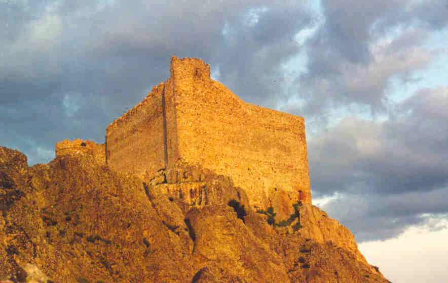
A medieval stone castle fortress sits on a craggy hilltop at sunset, illuminated by warm golden light against a cloudy sky.
The medieval Castle of Puebla de Alcocer perched atop a rocky hill in the La Siberia biosphere reserve.

La Siberia history and protected-area timeline

La Siberia's human story reaches back into prehistory, when its isolated inhabitants combined pastoral herding and hunting and left a record of painted rock shelters in the serranías. Sites such as the Navalvillar de Pela gold hoard, the Orellana torc, and decorated schist stelae along with warrior figures, weapons, and grave goods in cliff shelters document an active prehistoric and protohistoric presence. The most distinctive artistic remains are concentrated in the sierras of Talarrubias, Navalvillar, and the transition toward the Valle de Alcudia, with the Peñón del Buitre standing out for its depictions of chariots and weapons.

Under Rome the territory was organized through the new administrative system, with two notable urban centers: Lacimurga Constantia Iulia at the Cerro de Cogolludo, near Navalvillar de Pela, and Mirobriga at Cerro del Cabezo, near Capilla. Both received the ius Latii under Vespasian in 73-74 AD and have produced monumental and epigraphic finds, as well as systematic excavations revealing the deep roots of both sites.

The medieval period defined the comarca more sharply than any other era. Until 1085, these lands belonged to the Taifa of Toledo, and even after Alfonso VI took Toledo, the remote northeast of Badajoz remained a contested frontier. Muslim strongholds at Capilla, Almorchón, Alcocer, Puerto Peña, and Herrera faced Christian fortifications at Muro, Dos Hermanas, Malamoneda, and Milagro. The Christian victory at Las Navas de Tolosa in 1212 changed the pace of the Reconquista, and between 1212 and 1230 the territory was progressively absorbed into Castile. Alfonso Téllez de Meneses led the initial repopulation from 1222, and after his death the territory fell increasingly under the archbishopric of Toledo, the military orders of Alcántara and the Temple, and the noble houses of Belalcázar and Puebla de Alcocer. Castilblanco and Valdecaballeros, by contrast, were administered through Talavera de la Reina.

The early modern period was marked by administrative reshuffling. The Catholic Monarchs' 1502 fiscal provinces grouped the comarca with Salamanca rather than recognizing it as distinct Extremaduran territory, and only in 1653 was the province of Extremadura formally created. Even then, ecclesiastical dependence on the archbishopric of Toledo remained intact. The 1833 provincial division attached the comarca firmly to Badajoz, and the 1834 subdivision into partidos judiciales of Herrera del Duque and Puebla de Alcocer shaped administrative life for more than a century. The partido of Puebla de Alcocer disappeared in 1965, and its municipalities were absorbed mainly into Herrera del Duque, crystallizing the modern identity of the seventeen-town comarca of La Siberia.

The late nineteenth and twentieth centuries added the comarca's cultural identity. The nicknaming of the area as "La Siberia" by travelling salesmen, contrasted with the Russian Siberia in periodical press, was reinforced by José Ramón Mélida's 1908 descriptions in El Correo de Madrid and the Noticiero Extremeño. The Primo de Rivera dictatorship attempted to dispel the negative connotations through a 1926 press campaign, and the term became a national metaphor for deep Spain after the tragic Castilblanco events during the Second Republic. A 2016 candidacy for biosphere reserve status, initially supported by the Diputación de Badajoz and the Junta de Extremadura, suffered withdrawals from several municipal councils following agricultural opposition, before UNESCO finally designated the area as the La Siberia Biosphere Reserve in 2019.

La Siberia landscape and geographic character

The landscape of La Siberia is best read as three concentric zones. In the north and center, a dense succession of serranías (El Aljibe, La Dehesilla, La Lobera, La Rinconada, Barbas de Oro, Los Pastillos, Manzano, Peloche, Los Golondrinos, Consolación, Chamorro, La Chimenea, Escorial, Los Villares, Mirabueno, Santana, Sierra del Castillo, Lares, and Siruela) form the southernmost extensions of the Montes de Toledo, connecting directly to the Las Villuercas massif. These are rugged, sharply broken mountain blocks whose linear crests and steep scarps drop abruptly onto the valleys below. More than ninety percent of the terrain sits between 400 and 800 meters of elevation, with the highest summit, Pico Montilla, reaching 940 meters in the eastern Sierra de la Umbría group.

Through these serranías the Guadiana and Zújar have carved deep valleys, and their waters have been dammed into the chain of large embalses that now define the comarca's hydrological identity. Cíjara, García de Sola, and Orellana line the middle Guadiana, while the Zújar and the vast La Serena reservoir occupy the southern third. The resulting inland coastline gives La Siberia an extraordinary stretch of reservoir shore that contrasts with the otherwise landlocked feel of its high serranías.

To the south, the topography softens. Rolling plains spread gradually toward the Zújar watershed, offering wide horizons and an agricultural matrix that supports the older dehesa landscape and the cereal cultivation that has historically sustained the local population. Throughout the comarca, slope aquifers feed numerous springs, and a thermal spring has supported a balneario since at least the early nineteenth century. The combined action of mid-twentieth-century reforestation with pine, eucalyptus, and poplar along reservoir margins, and the unbroken mantle of holm oak and cork oak across the uplands, gives the landscape a strongly Mediterranean character softened by water.
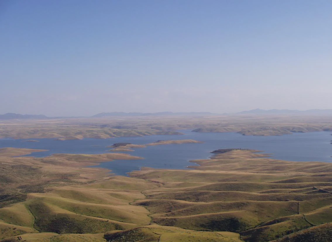
A wide, elevated landscape view featuring a large blue reservoir winding through rolling, dry golden hills under a clear sky.
A wide aerial view of the La Serena Reservoir, showing its expansive waters surrounded by the rolling, golden terrain of the La Siberia biosphere reserve.

La Siberia ecosystems, habitats, and plant life

The ecological identity of La Siberia is built on the mediterranean sclerophyllous forest. Holm oak dominates most of the territory, accompanied by cork oak in the more humid and shaded slopes and by a scattered presence of quejigo, a relatively rare oak in Extremadura. The mature forest understorey forms a dense Mediterranean shrub layer of strawberry tree, durillo, labiérnago, lentisco, cornicabra, myrtle, kermes oak, and spurge flax, with extensive reforestation of resin and stone pines and eucalyptus on the serranías and along reservoir shores.

The reservoirs form a complementary habitat axis. Orellana is officially designated as a Special Protection Area for Birds (ZEPA) and a Special Conservation Zone under Extremadura's nature conservation law, supporting a wide range of waterbirds. The cliffs, in turn, host raptors above the treeline. More than half of the Badajoz province's griffon vulture population nests in the serranía cliffs of La Siberia, and the crags also host Bonelli's eagle, golden eagle, Egyptian vulture, peregrine falcon, eagle owl, cinereous vulture, Spanish imperial eagle, and black stork. The towns themselves support distinctive urban fauna, including white stork, lesser kestrel, barn owl, swallow, and swift.

On the ground, the Cijara Regional Hunting Reserve harbours the most visible large mammals: wild boar, red deer, fallow deer (in restricted areas), and roe deer. Smaller game includes red-legged partridge, wood pigeon, turtle dove, hare, and rabbit. The reservoirs also support an important freshwater fish fauna, with carp, barbel, comizo, cabecicorto, pike, boga, and black bass among the species targeted by anglers, alongside smaller native species such as pardilla, cacho, colmilleja, calandino, and gambusia.
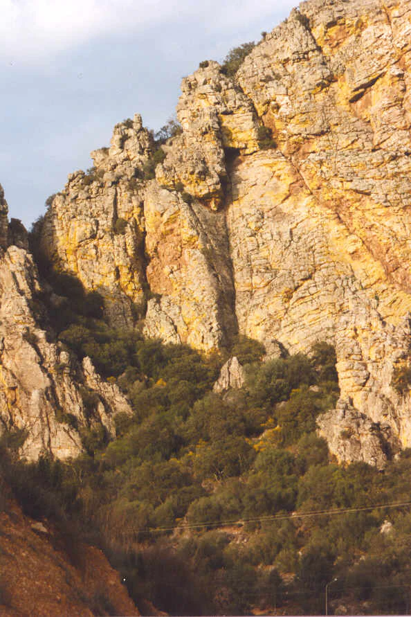
A steep, craggy yellow and grey rock cliff face rising above a dense slope of green scrubland and trees.
The rugged cliffs of Sierra de Puerto Pena in La Siberia, Spain.

La Siberia wildlife and species highlights

La Siberia hosts a remarkably rich vertebrate fauna, with representatives of nearly all of Extremadura's approximately 500 wild vertebrate species present within its borders. Its raptor populations are especially notable. The serranía cliffs host the largest share of the Badajoz province's breeding griffon vulture population, and the same landscape also supports Bonelli's eagle, golden eagle, Egyptian vulture, peregrine falcon, eagle owl, cinereous vulture, Spanish imperial eagle, and black stork, among others. The range of habitats, from cliff to reservoir to dehesa to town, sustains a particularly complete guild of breeding raptors.

The reservoirs have produced a parallel richness of waterbirds, especially around the Orellana embalse, which is officially designated as a Special Protection Area for Birds. White stork nests prominently in the urban environment, while lesser kestrel, barn owl, swallow, and swift are regular sights in the villages. In the woodlands and dehesas, typical Mediterranean forest species fill the avifauna.

The Cijara Regional Hunting Reserve forms the core of the comarca's mammalian presence, with wild boar, red deer, fallow deer (in very localized areas), and roe deer as the main large species. Smaller game species include red-legged partridge, wood pigeon, turtle dove, hare, and rabbit. The reservoirs additionally maintain diverse freshwater fish communities used by anglers and ecologically important small native cyprinids.

La Siberia conservation status and protection priorities

La Siberia became a UNESCO Biosphere Reserve in 2019, an official recognition of the comarca's exceptional combination of Mediterranean woodland, freshwater habitats, and serranía cliff ecosystems. The Reserve designation followed a difficult candidacy launched in 2016 by the Diputación de Badajoz and the Junta de Extremadura, which initially drew broad municipal support. Five of the eleven Mancomunidad de Municipios Siberia councils withdrew following objections from agricultural associations such as ASAJA, and the Assembly of Extremadura declined to back the initiative, putting the project in suspense until UNESCO's eventual recognition.

The biosphere reserve framework now overlays a long-standing conservation fabric. The Orellana reservoir is designated both a Special Protection Area for Birds (ZEPA) and a Special Conservation Zone under Extremadura's 1998 nature conservation law. The serranía cliffs are recognized as critical breeding habitat for the griffon vulture, with more than half of the Badajoz provincial population nesting in the area. The Cijara Regional Hunting Reserve provides structured management of large mammal populations and prevents the abandonment-driven degradation of the forest landscape.

Beyond formal designations, the comarca's reservoir system itself has conservation importance. Beyond their role in irrigation, hydropower, and local water supply, the five large embalses provide extensive wintering and breeding habitat for waterbirds and sustain relict freshwater fish communities. The reforestation with pine, eucalyptus, and poplar around reservoir margins, while often economically abandoned, contributes to soil retention and the prevention of siltation that would otherwise degrade these habitats.

La Siberia cultural meaning and human context

La Siberia carries a layered cultural identity built on centuries of borderland life, religious and military administration, and small-scale rural communities. Until the twentieth century, the most striking cultural feature was its isolation. The long distances to Badajoz and the parallel rise of the term "Siberia" in the press during the late nineteenth and early twentieth centuries turned the comarca into a national symbol of remote, under-serviced interior Spain, particularly after the Castilblanco events during the Second Republic.

Religious administration through the archbishopric of Toledo, a legacy of the medieval repopulation under Alfonso Téllez de Meneses and the military orders, persisted long after civil administration shifted to Badajoz. Noble families and military orders shaped the medieval territorial units: the condado of Belalcázar (later vizcondado of Puebla de Alcocer), the estado of Capilla under the dukes of Osuna, and the condado of Siruela.

Twentieth-century depopulation, driven by emigration to industrial cities, left an ageing population structure and weakened the agricultural workforce. Yet the comarca retained strong traditions: the transhumance festival at Siruela and Tamurejo, extensive home baking of pastries tied to Semana Santa and local fiestas, the persistence of pitarra home-made wine, the preparation of escarapuche in Peloche, salmorejo in Talarrubias and Puebla de Alcocer, and a rich tradition of game-based charcuterie linking directly to the Cijara hunting reserve. The annual Judesi inter-municipal school games, launched in 2006, are a contemporary expression of this small-community identity.

Top sights and standout views in La Siberia

La Siberia's defining qualities are the chain of five major reservoirs along the Guadiana and Zújar, the extensive Mediterranean oak woodland, and the serranía cliffs that host one of Spain's most important raptor communities. To these can be added the prehistoric rock art in the sierra shelters, the documented Roman urban nuclei of Lacimurga and Mirobriga, and the long frontier history that left noble and military-order administrative footprints across the territory.

The comarca is also distinguished by its UNESCO Biosphere Reserve status (achieved in 2019 after a delayed candidacy process), by the persistence of small-town traditions such as the transhumance festival at Siruela and Tamurejo, and by a deeply rooted rural culinary heritage centred on home-made charcuterie, game, pitarra wine, and a varied pastry tradition.

Best time to visit La Siberia

The climate of La Siberia is mediterranean subhumid, with about 60 to 70 days of rain per year, mild winters, and a long, dry summer. Spring and autumn are the most rewarding periods to visit the reservoirs and woodlands: the reservoirs sit at their fullest, the mediterranean shrub layer is in active growth or flowering, and the serranía roads and trails are generally accessible without summer heat. Wildlife observation, particularly for raptors, is most productive along the serranía cliffs and around Orellana during these seasons.

Summer, by contrast, brings sustained drought and high temperatures (often reaching the high 30s Celsius in July) but extended daylight and a lively local festival calendar in several of the municipalities. Winter is usually mild (with averages near 6-7 degrees Celsius in January) but rarely produces lasting snow, leaving the reservoirs accessible year-round despite occasional low-lying mist in the river valleys.
Monthly climate preview

Long-term monthly temperature and precipitation data for Extremadura

La Siberia Climate Normals and Measured Annual Temperature Patterns

Historical climate records for La Siberia reveal a measured annual rhythm of monthly average temperatures and precipitation rates spanning three decades. Examining the complete twelve-month statistical profile provides detailed insight into long-term environmental patterns across the protected landscape.
Annual mean16 °C
6 °C27 °C
Jan
Feb
Mar11°
Apr13°
May18°
Jun24°
Jul27°
Aug27°
Sep22°
Oct16°
Nov10°
Dec
Warmest month
July

27.5 °C

Coolest month
January

5.9 °C

Wettest month
October

1.9 mm/day

Driest month
July

0.2 mm/day

Park location guide

Geography guide, regional context, and park location map for La Siberia

La Siberia park geography, regions, and map view in Spain

Understand where La Siberia sits in Spain through a broader geographic reading of the surrounding landscape, nearby location context, and its mapped position within the national park landscape.

How La Siberia fits into Spain

Spain, officially the Kingdom of Spain, is a unitary parliamentary constitutional monarchy located in Southern and Western Europe. The country occupies most of the Iberian Peninsula and includes territories in the Mediterranean and Atlantic. With a population of approximately 49.6 million and an area of 506,030 km², Spain is a major European economy and cultural force. Its capital is Madrid, and the country is known for its diverse landscapes ranging from mountainous regions to coastal areas.

Wider geography shaping La Siberia in Spain

Spain occupies the Iberian Peninsula in Southern and Western Europe. Peninsular Spain is bordered to the north by France, Andorra, and the Bay of Biscay; to the east and south by the Mediterranean Sea and Gibraltar; and to the west by Portugal and the Atlantic Ocean. The territory includes the Canary Islands in the Atlantic Ocean, the Balearic Islands in the Mediterranean Sea, and the autonomous cities of Ceuta and Melilla in mainland Africa. Spain features diverse terrain including the Pyrenees in the northeast, the Sierra Nevada in the south, and the Meseta Central plateau.

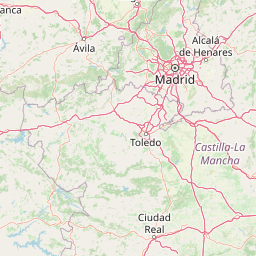
Map view of La Siberia

Use this park location map to pinpoint La Siberia in Spain, understand its exact geographic position, and read its mapped placement within the surrounding landscape more clearly.

Pigeon | © OpenStreetMap contributors

Location context for La Siberia

Extremadura

Explore photographic records of serranía ridges, inland reservoirs, and Mediterranean oak woodlands.

La Siberia Landscape Photos and Scenery: Visualizing Protected Habitats

Visual documentation captures the rugged topography, extensive water reservoirs, and oak woodlands that define La Siberia. Photographic records reveal the protected natural environment and distinct habitat features across the region.

A medieval stone castle fortress sits on a craggy hilltop at sunset, illuminated by warm golden light against a cloudy sky.

A group of four deer standing in the shade of a large, mature oak tree in a grassy, open woodland environment.

A wide, elevated landscape view featuring a large blue reservoir winding through rolling, dry golden hills under a clear sky.

A steep, craggy yellow and grey rock cliff face rising above a dense slope of green scrubland and trees.

Park atlas

Discover related protected areas, adjacent reservoir zones, and connected Mediterranean woodland habitats.

Parks Near La Siberia: Compare Protected Areas and Surrounding Regional Landscapes

Browsing parks near La Siberia allows travelers to examine adjacent mountain ranges, river valleys, and protected landscapes across interior Spain. Comparing these neighboring conservation zones provides deeper geographic context for the surrounding regional terrain and reservoir ecosystems.
Watercolor painting showing green fields, scattered trees, and distant mountains under a light sky
National parkToledo Province
About 43 km away#1 closest

Northeast

Cabañeros National Park: Spain's Premier Iberian Oak Woodland Protected Landscape

Mapped Geography of Montes de Toledo Protected Area

Cabañeros National Park is celebrated as the most extensive and well-conserved example of Iberian Mediterranean forest in Spain. Situated within the Montes de Toledo, the park features a remarkable dichotomy between its unique raña flatlands and mountainous sierras, harboring ancient oak woodlands and significant biodiversity. This national park serves as a crucial component of the region's geographic context and a prime destination for atlas-based discovery of protected landscapes.

Area
409 km²
Established
1995
IUCN
II
Visitors
104.6K annual
Watercolor illustration of rolling green hills, a winding river, and a distant horizon with a soft sun
National parkExtremadura
About 82 km away#2 closest

Northwest

Monfragüe National Park: Dramatic Cliffs, Raptor Haven, and Extremadura's Protected Landscape

Discover its mapped terrain and unique geography in Spain.

Monfragüe National Park, situated in Extremadura, Spain, offers a compelling study in protected landscape geography. The park's identity is shaped by its formidable cliffs and river valleys carved by the Tagus, providing critical nesting grounds for European raptors. This MoriAtlas entry details the park's mapped boundaries and its significance as a vital protected area within the region. Users can explore the specific natural terrain and regional context that establish Monfragüe as a unique protected territory.

Area
179 km²
Established
2007
IUCN
II
Visitors
331.8K annual
Watercolor painting of a river flowing through rolling hills with green fields and trees
National parkSpain
About 109 km away#3 closest

Northwest

Monfragüe National Park: Protected Landscape Atlas of Spanish Raptor Colonies

Explore mapped terrain and regional geography within this Spanish National Park.

As a national park in Spain's Extremadura region, Monfragüe National Park offers a distinct protected landscape shaped by the Tagus River and dramatic limestone cliffs. It is globally recognized for its exceptional birdlife, especially its large griffon vulture colonies and populations of Spanish imperial eagles, making it a significant site for ecological study and atlas-based exploration of protected areas. The park's landscape, characterized by Mediterranean woodlands and rugged terrain, provides crucial habitat and a unique geographic context for understanding Iberian Peninsula conservation.

IUCN
II
Scope
Terrestrial
Watercolor illustration showing a wetland landscape with grasses, a body of water, and distant hills
National parkSpain
About 114 km away#4 closest

East

Tablas de Daimiel National Park: Spain's Inland Wetland National Park and Protected Area

Explore mapped boundaries and regional geographic context.

Tablas de Daimiel National Park represents one of the last remaining examples of floodplain wetland systems in Spain's interior. Located in Castilla-La Mancha, this protected area showcases a unique confluence of fresh and brackish waters, supporting a rich mosaic of emergent vegetation and serving as a critical habitat for migratory birds. Use MoriAtlas to explore its precise geographic setting, mapped terrain, and its role as a vital conservation landscape within the Iberian Peninsula.

Area
30.3 km²
Established
1973
IUCN
II
Relief
Lowland
Watercolor illustration of a landscape with green hills, scattered trees, and distant mountains under a pink and yellow sky
Protected landscapePortalegre District
About 176 km away#5 closest

West

Serra de São Mamede Natural Park: A Protected Landscape Defined by Ecological Transition

Explore the unique mountain terrain and ecosystems of Portalegre District.

Delve into the geographic and ecological identity of Serra de São Mamede Natural Park, a significant protected landscape situated in Portugal's Portalegre District. This area is renowned for its dramatic quartzite ridges and its role as a crucial meeting point for Atlantic and Mediterranean plant communities, offering a unique atlas perspective on regional biodiversity. Examining its mapped boundaries and diverse terrain provides essential context for understanding its ecological importance and its distinct position within the Alentejo region's geography.

Area
560.6 km²
Established
1989
IUCN
V
Visitors
4.5K annual
Watercolor illustration depicting a mountain range, river, and green vegetation under a light sky
National parkSpain
About 195 km away#6 closest

Northeast

Sierra de Guadarrama National Park: Protected Area Landscape and Geographic Context

Explore diverse high Mediterranean mountain terrain and ecosystems.

Sierra de Guadarrama National Park is a significant protected national park in central Spain, characterized by its extensive granite landscapes and eleven distinct ecosystems. This park protects crucial high Mediterranean mountain environments, ancient pine forests, and dramatic glacial formations. Its geographic position within the Sistema Central makes it essential for understanding the regional geography and mapped terrain of the Iberian Peninsula, offering a unique look at a vital protected landscape.

Area
339.6 km²
Established
2013
IUCN
II
Visitors
3M annual
Watercolor illustration of a landscape with green mountains, a body of water, and colorful wildflowers in the foreground
Nature reservePortugal
About 238 km away#7 closest

Northwest

Serra da Estrela Natural Park: Glacial Terrain and Highest Peaks in Portugal

Explore the dramatic geography of this nature reserve.

Serra da Estrela Natural Park is a significant protected landscape in Portugal, celebrated for containing the nation's highest peak and exceptional Quaternary glacial formations. The park's terrain includes dramatic valleys carved by ice, numerous glacial lakes, and a stark alpine plateau around Torre. This nature reserve preserves a unique environment shaped by both geological history and traditional pastoralism, offering rich mapped context for understanding Portugal's mountainous geography and protected areas.

Area
891.32 km²
Established
1976
IUCN
V
Visitors
7.6K annual
Watercolor painting of a rolling green mountainous landscape featuring soft hills and a foreground meadow.
Biosphere reserveMadrid
About 242 km away#8 closest

Northeast

Sierra del Rincón Biosphere Reserve: Mountain Geography and Protected Landscape Analysis

Transitional mountain terrain in the Sierra Norte region of Madrid

Sierra del Rincón provides a unique study of ecological compression, where Atlantic-flavored beech groves meet Mediterranean oak and highland shrublands. This protected mountain territory in Madrid integrates rich forest habitats with traditional agro-silvopastoral village life, making it a critical reference for understanding the transitional geography of the Iberian Central System.

Area
152.31 km²
Established
2005
Relief
Mountain
Climate
Alpine

Common questions about visiting, size, designation, and location context for La Siberia

La Siberia FAQs for park facts, access, geography, and protected area context

Find quick answers about La Siberia, including protected-area facts, park geography, trail and visitor context, and how the park fits into its surrounding country and regional landscape.
MoriAtlas Explorer

Continue Your Protected Areas Search Across the Global Atlas

Deepen your exploration by continuing the structured search for national parks and protected areas worldwide. Utilize the comprehensive filtering capabilities to compare different conservation landscapes and refine your understanding of global park geography. Discover more about the distribution and characteristics of protected natural areas.

Global natural geography