
Mori Atlas logo
Natural monumentLaguna de Urao

Tracing the geological origins and environmental significance of this landmark in the Venezuelan Andes

Laguna de Urao Natural Monument: An Examination of its Saline Tectonic Geography and Landscape

(Laguna de Urao (Monumento Natural))

Laguna de Urao stands as a distinct protected saline lake nestled within the semi-arid terrain of the Venezuelan Andes near Lagunillas. Recognized as a Natural Monument, the site features a unique tectonic basin that has shaped local regional geography and cultural history for generations. This examination offers detailed insight into the hydrological characteristics of the lagoon and its position within the broader mountainous landscape of Mérida.

saline lagoonandestectonic lakenatural monumentvenezuelamerida
A graphic illustration featuring stylized steep rocky mountains, a flowing river, a waterfall, and evergreen trees in the foreground, rendered in a warm, sunset-toned color palette.

Laguna de Urao

Natural monument

Park overview

Structured park overview, official facts, and landscape profile for Laguna de Urao

Laguna de Urao park facts, protected area profile, and essential visitor context

Review the core facts for Laguna de Urao, including designation, size, terrain, visitor scale, habitats, and operating context in one park-focused overview.

About Laguna de Urao

Laguna de Urao is a small saline lagoon set in the Venezuelan Andes, west of the state of Mérida and just outside the town of Lagunillas. Although it lies in a highland region more typically associated with cooler mountain landscapes, the surrounding setting is described as semi-arid, which makes the presence of an open body of water a distinctive feature of the area. The lake itself came into existence through tectonic processes, and its saline mineral content comes from the chemical interaction of underground waters and sediments that flow into the basin.

The lake's most striking identity, however, is cultural and mineralogical. The urao mineral that gave the lagoon its name is a natural sesquicarbonate of sodium that crystallizes from these saline waters. For centuries, indigenous peoples of the region visited the lagoon to retrieve mineral-rich material from its bed, returning to process it into chimó, a powdered preparation blended with dried tobacco leaves that remains a defining cultural product of the Merida Andes. This direct link between the lake, the mineral, and the region's most recognizable traditional substance gives Laguna de Urao a significance that goes well beyond its modest dimensions.

In modern times, the lagoon is recognized as a Natural Monument of Venezuela, a designation granted in 1979 to preserve its natural and historical importance. Local tradition attributes the lagoon with an enigmatic, almost sacred atmosphere, with stories of protective spirits and guardian serpents that are part of the oral memory surrounding the site. Together, its geology, mineral content, traditional use, and local legends make Laguna de Urao a layered landmark within the cultural geography of the Venezuelan Andes.

Quick facts and research context for Laguna de Urao

Laguna de Urao is a natural saline lagoon of tectonic origin located in the Sucre municipality, west of the state of Mérida, Venezuela, near the town of Lagunillas. It was officially declared a Natural Monument (Monumento Natural) by decree on 18 June 1979. The lake is known for the presence of urao, a natural sodium sesquicarbonate deposited by underground waters and sediments.

The lagoon measures roughly 870 meters in length and is approximately 5 meters deep on average. Beyond its geological character, it is recognized as a culturally significant site because of its historical role as a source of urao for the preparation of chimó, a substance deeply rooted in local indigenous and mestizo traditions.

Park context

Deeper park guide and search-rich context for Laguna de Urao

Laguna de Urao history, landscape, wildlife, and travel context

Explore Laguna de Urao through its history, landscape character, ecosystems, wildlife, conservation priorities, cultural context, and seasonal travel timing in a structured park guide built for atlas discovery and search intent.

Why Laguna de Urao stands out

Laguna de Urao is best known for being the historical source of urao, a natural sodium sesquicarbonate once harvested from the lake bed and used to prepare chimó, the traditional Andean tobacco preparation. It also stands out as an unusual saline lake within a generally semi-arid Andean landscape, combining geological interest with strong indigenous cultural memory.
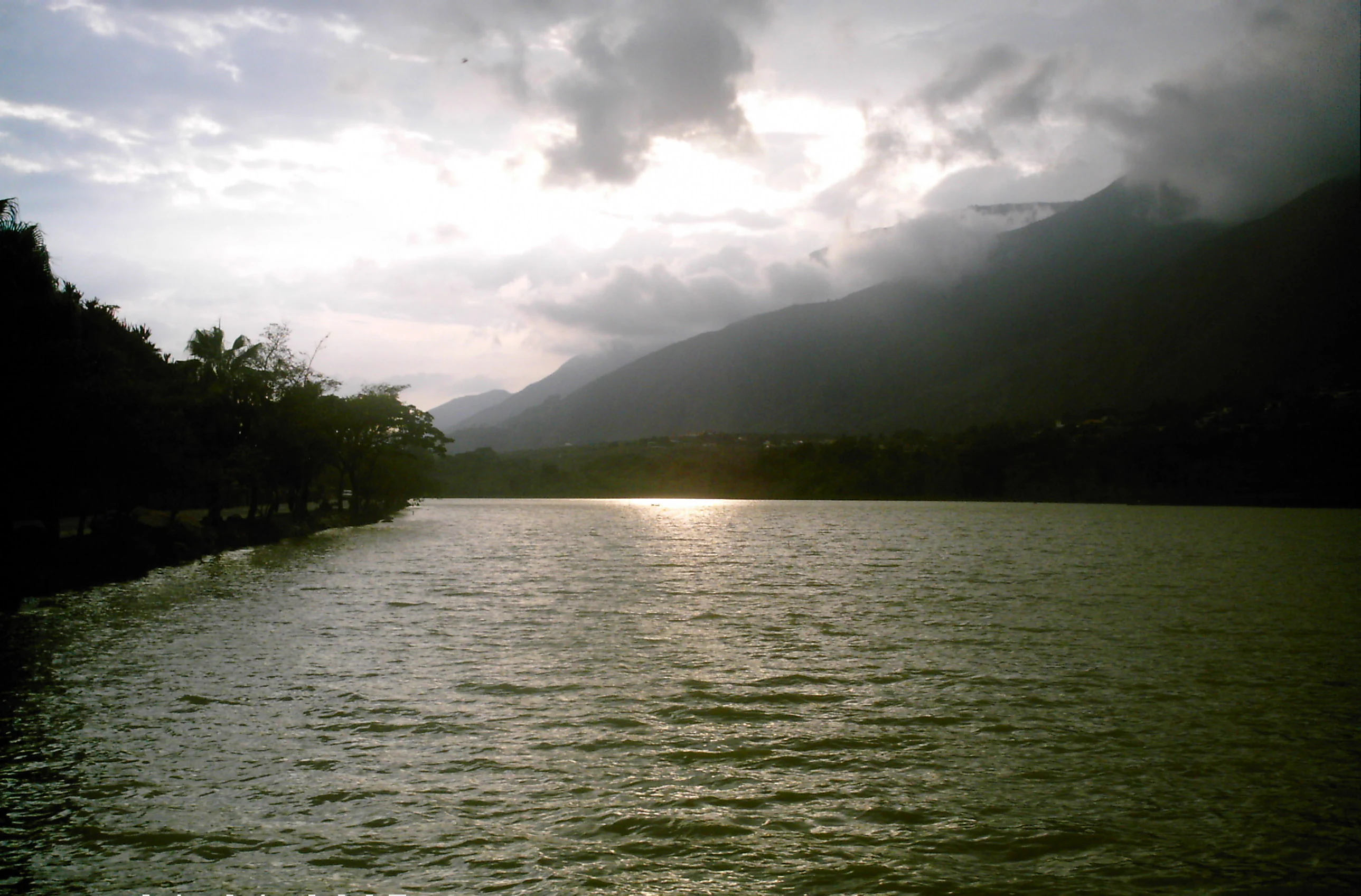
A wide view of a lake reflecting the sun with mountains in the background under a cloudy sky.
A view of Laguna de Urao under cloudy skies.

Laguna de Urao history and protected-area timeline

Laguna de Urao is closely tied to the early colonial history of western Venezuela. Late in 1558, the Spanish captain Juan Rodríguez Xuárez, then ordinary mayor of Pamplona in present-day Colombia, led an expedition aimed at subduing indigenous resistance near Sierra Nevada La Arboleda and Chicagua, and at founding new settlements. As his expedition moved through what became the states of Táchira and Mérida, it encountered a saline lake whose indigenous name was Yohama, which was later called Laguna de Urao. The conquistador baptized the surrounding settlement as Lagunillas, and from this area the city of Mérida itself was founded soon afterward.

Long before the Spanish arrival, indigenous communities in the region had been using the lagoon as a source of urao, a mineral they retrieved by diving into its waters. The mineral was essential in producing chimó, a tobacco-based preparation that became a widespread product of regional consumption and, by the mid-twentieth century, an important commercial activity for Lagunillas and surrounding communities. The cultural and economic weight of this extractive tradition long outlasted the colonial era.

The lagoon's official recognition as a Natural Monument came in 1979, by way of decree number 172, issued 18 June 1979 and published the following day in the official gazette. Although local commentary in recent years has raised concerns about possible ecological pressures affecting the site, the formal protected status of 1979 anchors its modern environmental and heritage identity.

Laguna de Urao landscape and geographic character

Laguna de Urao occupies a notable position in the Andean landscape because it is one of the few saline water bodies of tectonic origin in western Venezuela. The surrounding territory is generally semi-arid, making the presence of a standing lake an unusual and visually distinctive element within the broader scenery of the Mérida Andes. The lake is elongated, measuring roughly 870 meters in length, with an average depth of around 5 meters.

The lagoon's appearance contributes to a calm, reflective atmosphere that visitors and locals describe as quietly striking. Its saline origin, tied to underground waters and mineral sediments, sets it apart visually and chemically from typical highland lakes, and reinforces the sense that the site is a singular natural feature within an otherwise dry regional environment.

Laguna de Urao ecosystems, habitats, and plant life

Ecologically, Laguna de Urao is defined less by its size than by the chemical character of its waters. The lake is saline due to the steady contribution of underground mineralized water and sedimentary deposits, which produce urao, a sodium sesquicarbonate that crystallizes near the bed and along parts of the shoreline. Its chemistry gives the site a particular biological profile uncommon in the surrounding Andean landscape.

The semi-arid framing around the lake enhances its ecological uniqueness. Rather than fitting the moist montane ecosystem more typical of its elevation in the Venezuelan Andes, the lagoon forms a mild micro-environment shaped by salinity, mineral accumulation, and limited surface inflow. This combination of geology, hydrology, and chemistry gives Laguna de Urao a distinct ecological footprint that has justified its recognition as a protected natural monument.

Laguna de Urao conservation status and protection priorities

Laguna de Urao is a formally protected natural area. On 18 June 1979, by decree number 172, published the next day in Venezuela's official gazette, the lagoon was declared a Natural Monument (Monumento Natural), granting it state-level recognition for its geological, ecological, and historical importance. The designation reflects the view that the lake is a unique saline ecosystem within a semi-arid Andean context, and a site whose identity is inseparable from the indigenous and regional history of urao extraction and chimó production.

Beyond its formal monument status, the lagoon's conservation value rests on the combination of its tectonic origin, its mineral-rich saline waters, and its persistent cultural relevance. In recent years, local observers have expressed concern about potential environmental pressures affecting the site, underscoring the perception that the lagoon, despite its modest size, is a fragile landmark whose loss would erase a piece of natural and regional heritage.

Laguna de Urao cultural meaning and human context

Laguna de Urao holds a deep place in the cultural memory of the Venezuelan Andes. For indigenous peoples of the region, the lake was a sacred or magical-religious space long before the Spanish arrival, and served as the source of urao, the mineral used to prepare chimó in combination with dried tobacco leaves. Chimó has remained a defining Merideño tradition, and for centuries the lake sustained a trade that, by the mid-twentieth century, still represented an important source of income for Lagunillas and nearby communities.

Local oral tradition continues to surround the lagoon with legends. Stories speak of spirits residing in its waters, of a great guardian serpent inhabiting the depths, and even of a myth that the lagoon once flew through the sky from the high páramos before settling in its present valley. Combined with its role as a colonial-era reference point during the founding of Mérida, this layered mix of indigenous memory, regional tradition, and folklore gives Laguna de Urao a cultural weight that well exceeds its physical dimensions.

Top sights and standout views in Laguna de Urao

The principal highlights of Laguna de Urao are its identity as a saline tectonic lake in an otherwise semi-arid Andean landscape, its protected Natural Monument status granted in 1979, and its role as the historical source of the urao mineral used in the preparation of chimó. The lagoon also stands out because of the depth of indigenous and colonial history tied to it, ranging from pre-Hispanic ritual use to the foundational story of Lagunillas and Mérida.
Monthly climate preview

Long-term temperature ranges and monthly precipitation averages for Mérida

Laguna de Urao Climate Normals and Annual Weather Patterns

Measured NASA Power coordinates reveal the long-term temperature and precipitation rhythm across twelve distinct observation cycles at Laguna de Urao. Examining the complete monthly climate normals provides deeper insight into historical averages without relying on live forecasts.
Annual mean17 °C
17 °C18 °C
Jan17°
Feb17°
Mar18°
Apr18°
May18°
Jun17°
Jul17°
Aug17°
Sep17°
Oct17°
Nov17°
Dec17°
Warmest month
April

18.1 °C

Coolest month
July

16.7 °C

Wettest month
May

6 mm/day

Driest month
January

1 mm/day

Park location guide

Geography guide, regional context, and park location map for Laguna de Urao

Laguna de Urao park geography, regions, and map view in Venezuela

Understand where Laguna de Urao sits in Venezuela through a broader geographic reading of the surrounding landscape, nearby location context, and its mapped position within the national park landscape.

How Laguna de Urao fits into Venezuela

Venezuela is a country in northern South America with coastline along the Caribbean Sea and Atlantic Ocean. It borders Colombia, Brazil, Guyana, and Trinidad and Tobago. The country has an area of approximately 916,445 km² and a population of about 31.8 million. Caracas is the capital and largest city. Venezuela consists of 23 states and the Capital District.

Wider geography shaping Laguna de Urao in Venezuela

Venezuela is located on the northern coast of South America. The continental territory is bordered by the Caribbean Sea and Atlantic Ocean to the north, Colombia to the west, Brazil to the south, and Guyana to the east. Trinidad and Tobago lies to the northeast. The country includes various islands and islets in the Caribbean Sea known as the Federal Dependencies.

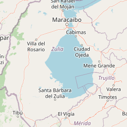
Map view of Laguna de Urao

Use this park location map to pinpoint Laguna de Urao in Venezuela, understand its exact geographic position, and read its mapped placement within the surrounding landscape more clearly.

Pigeon | © OpenStreetMap contributors

Location context for Laguna de Urao

Mérida

Examine protected area views, unique tectonic water bodies, and semi-arid terrain.

Laguna de Urao Photos and Landscapes: Visual Explorer of the Andean Saline Lake

Visual documentation captures the striking contrast of a tectonic saline lake resting inside a semi-arid Andean valley. Photographic records reveal the unique geological features, mineral-rich shorelines, and broader regional environment that define the protected landscape.

A wide view of a lake reflecting the sun with mountains in the background under a cloudy sky.

Park atlas

Compare regional protected landscapes and Andean terrain features

Parks Near Laguna de Urao and Surrounding Protected Areas

Browse protected areas and natural landmarks located near Laguna de Urao to examine wider regional geography. Comparing adjacent highland terrain reveals how unique geological formations fit into the broader Andean landscape.
National parkVenezuela
About 6.1 km away#1 closest

Northeast

Sierra La Culata National Park: Protected Landscape Atlas of the Venezuelan Andes

Explore the páramo ecosystems and mapped terrain of this Venezuelan national park.

Sierra La Culata National Park offers a profound look into the unique geography of the Venezuelan Andes. This protected national park is characterized by its expansive páramo ecosystems, dramatic mountain peaks, and glacial lagoons, creating a distinctive high-altitude wilderness. Use this atlas-focused entry to understand the park's mapped boundaries and its significant role within the region's natural landscape context.

Area
2,004 km²
Established
1989
IUCN
II
Relief
Mountain
Watercolor painting showing green hills, a river, and distant mountains under a light sky
National parkVenezuela
About 12 km away#2 closest

East

Sierra Nevada National Park: Venezuela's Majestic Alpine Protected Landscape and Park Boundaries

Explore the highest peaks and glacial terrain of this Venezuelan national park.

Delve into Sierra Nevada National Park, a premier protected area situated in the high Venezuelan Andes. This national park protects a vast expanse of dramatic alpine terrain, including Pico Bolívar and numerous glacial valleys. Understand its mapped boundaries and the unique paramo and cloud forest ecosystems that define this significant natural landscape within Venezuela, offering rich context for atlas-style geographic discovery.

Area
2,764.46 km²
Established
1952
IUCN
II
Relief
Mountain
Natural monumentMérida
About 29 km away#3 closest

West

Monumento natural Meseta la Galera: Protected Andean Plateau and Geography Map

Analyzing the fluvial terrain and forest landscape of Tovar, Merida.

Monumento natural Meseta la Galera serves as a vital geographic landmark near Tovar, Merida. This protected natural monument preserves a rare flat topped plateau rising over the Mocoties River valley. Examine the structured map context of this 95 hectare forest refuge and its defined topographical boundaries within the Andean mountain foothills.

Area
0.95 km²
Established
1992
IUCN
III
Relief
Highland
National parkBarinas
About 50 km away#4 closest

Southeast

Tapo-Caparo National Park: Mapped Boundaries and Geographic Context in Barinas, Venezuela

Explore Venezuela's Tapo-Caparo National Park's protected terrain.

Tapo-Caparo National Park is a vital protected area located in the Barinas region of Venezuela. This page offers an atlas-focused exploration of its mapped natural landscape and geographic significance within the country. Understand the protected boundaries and the specific terrain features that define Tapo-Caparo National Park, providing essential context for regional geography and protected land discovery.

Area
2,050 km²
Established
1992
IUCN
II
Relief
Mountain
Watercolor illustration showing a serene landscape with a lake in the foreground, green vegetation along the banks, and pink-hued mountains in the background under a pale cream sky
National parkMérida
About 84 km away#5 closest

Southwest

Parque nacional General Juan Pablo Peñaloza: Andean Paramo and Highland Geography Atlas

Protected mountainous terrain and glacial water networks

Spanning elevations from 1,800 meters to the 3,942-meter summit of Pico El Púlpito, this national park preserves an expansive mosaic of paramo and montane forest. The terrain features over 130 periglacial lakes, including Laguna Blanca and Laguna Grande, which sustain regional river systems and support unique species like the Andean bear and mountain tapir.

Area
752 km²
Established
1989
IUCN
II
Relief
Mountain
National parkVenezuela
About 84 km away#6 closest

Southwest

General Juan Pablo Peñaloza National Park: Venezuela National Park Atlas Entry

Mapped boundaries and regional geographic context for a protected natural area.

Explore General Juan Pablo Peñaloza National Park, a key protected area designated as a national park in Venezuela. This detailed entry focuses on its landscape identity, mapped boundaries, and its contribution to Venezuela's broader regional geography. Understand the park's significance as a protected natural area and its atlas context for in-depth geographic study.

Area
752 km²
Established
1989
Relief
Mountain
Climate
Alpine
National parkTrujillo
About 117 km away#7 closest

Northeast

Parque nacional Dr. José Gregorio Hernández: Andean Mountain and Watershed Geography

High-altitude protected habitats in the Venezuelan Andes

This national park protects a vast stretch of Andean terrain, serving as an essential ecological link between major mountain reserves. Its steep ridges and river valleys represent a critical habitat for the spectacled bear while securing the water sources of regional watersheds.

Area
505 km²
Established
2021
IUCN
II
Relief
Mountain
National parkTáchira State
About 119 km away#8 closest

Southwest

Chorro El Indio National Park: Protected National Park in Táchira State's Geography

Explore mapped boundaries and regional landscape context.

Chorro El Indio National Park serves as a key protected landscape within Táchira State, Venezuela. This national park offers users detailed insights into its specific geographic setting, mapped park boundaries, and the natural terrain it encompasses. Understanding Chorro El Indio National Park through the MoriAtlas platform provides a foundation for exploring regional protected areas and their ecological significance.

Area
170 km²
Established
1989
IUCN
II
Relief
Mountain

Common questions about visiting, size, designation, and location context for Laguna de Urao

Laguna de Urao FAQs for park facts, access, geography, and protected area context

Find quick answers about Laguna de Urao, including protected-area facts, park geography, trail and visitor context, and how the park fits into its surrounding country and regional landscape.
MoriAtlas Explorer

Continue Your Protected Areas Search Across the Global Atlas

Deepen your exploration by continuing the structured search for national parks and protected areas worldwide. Utilize the comprehensive filtering capabilities to compare different conservation landscapes and refine your understanding of global park geography. Discover more about the distribution and characteristics of protected natural areas.

Global natural geography