
Mori Atlas logo
Protected areaLaguna di Marceddì

Mapping the brackish lagoons, tidal channels, and waterbird habitats of western Sardinia

Laguna di Marceddì: A Comprehensive Geographic Profile of a Sardinian Protected Coastal Wetland

Laguna di Marceddì represents a vital coastal wetland ecosystem on the western shore of Sardinia, Italy. This protected landscape encompasses roughly nine square kilometers of tidal flats and shallow basins fed by the Rio Mogoro and Rio Sitzerri. Beyond its status as an international wetland, the site demonstrates a unique interplay between Mediterranean saline environments and the local agricultural hinterland, functioning as a sustained habitat for waterbirds and traditional lagoon fisheries.

coastal lagoonwetlandRamsar siteSpecial Protection AreaSardiniaMediterranean
A digital illustration of a mountainous coastal landscape with a lagoon, a small boat, a waterfall, and evergreen trees under a sunlit sky.

Laguna di Marceddì

Protected area

Park overview

Structured park overview, official facts, and landscape profile for Laguna di Marceddì

Laguna di Marceddì park facts, protected area profile, and essential visitor context

Review the core facts for Laguna di Marceddì, including designation, size, terrain, visitor scale, habitats, and operating context in one park-focused overview.

About Laguna di Marceddì

Laguna di Marceddì is one of the most significant coastal lagoons on the western Sardinian coast, a region where large stretches of flat coastal plain have historically been shaped by both natural hydrology and human intervention. The lagoon sits at the interface between several municipalities of the Medio Campidano and Oristano areas, functioning as a transitional zone among freshwater inflows, brackish basins, and the open Mediterranean. This positioning gives it the ecological character typical of productive Mediterranean coastal lagoons, with subtle salinity gradients, tidal exchanges, and shallow productive beds.

What distinguishes Marceddì in the regional context is the pairing of strong conservation recognition with continued use as a working fishery. The lagoon has been listed since the 1970s among wetlands of international importance under the Ramsar Convention, and it has subsequently been classified as a Special Protection Area under the European Birds Directive, with the official code ITB034004. These overlapping designations reflect the lagoon's value for migratory and resident waterbirds while also acknowledging that the site remains a place where traditional lagoon management is practiced.

Administratively, the lagoon belongs to the demesne of the Region of Sardinia, and the regional authority grants licenses for the professional exploitation of its fish resources. This arrangement produces a distinctive governance profile in which ecological protection and artisanal fishery are co-managed within the same waterbody. As such, Laguna di Marceddì functions simultaneously as a protected natural area and as a productive coastal ecosystem embedded in the regional economy.

Quick facts and research context for Laguna di Marceddì

Laguna di Marceddì lies on the western coast of Sardinia in the province of Oristano, straddling the municipal territories of Arbus, Arborea, Guspini, and Terralba. The lagoon spans roughly 9 square kilometers of brackish coastal wetland, fed primarily by the rio Mogoro and rio Sitzerri before meeting the sea.

Protection and recognition

Mixed conservation scope and established designation timeline for Laguna di Marceddì

Laguna di Marceddì Protection Status and Designated History

Historical records indicate a mixed protection scope established for Laguna di Marceddì in 1970. Official documentation tracks structural designation milestones and management parameters for this protected area.

Protection details

Protection scope
Mixed
Designated year
1970
Park context

Deeper park guide and search-rich context for Laguna di Marceddì

Laguna di Marceddì history, landscape, wildlife, and travel context

Explore Laguna di Marceddì through its history, landscape character, ecosystems, wildlife, conservation priorities, cultural context, and seasonal travel timing in a structured park guide built for atlas discovery and search intent.

Why Laguna di Marceddì stands out

The lagoon is best known as a Ramsar-listed wetland and Special Protection Area that combines internationally recognized waterbird habitat with a still-active traditional fishery. Its position on a stretch of Mediterranean coastline that is otherwise heavily altered for agriculture gives it particular significance as a remnant of natural coastal lagoon systems in Sardinia.
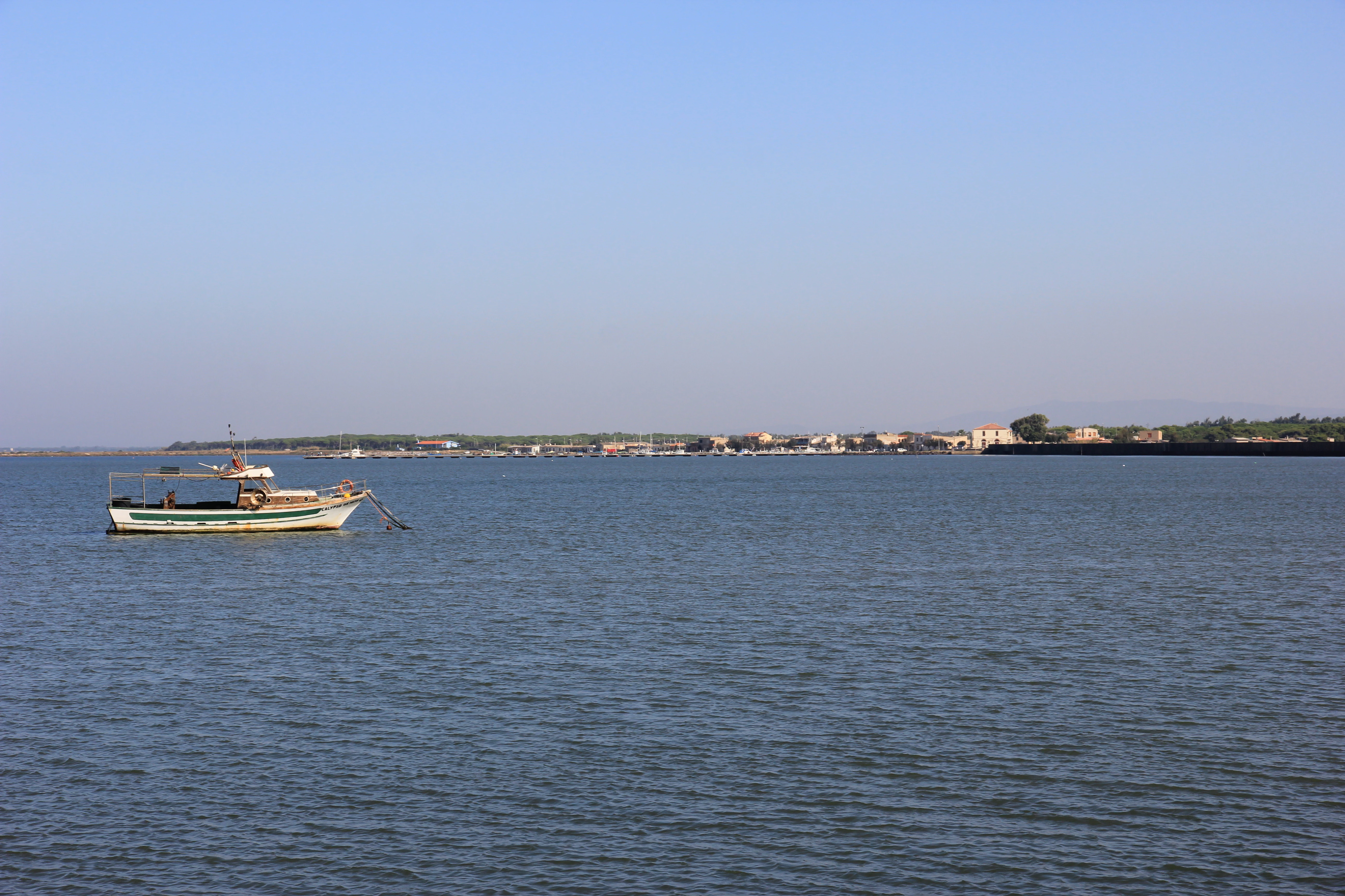
A wide view of a calm lagoon with a small fishing boat anchored in the left foreground and a distant shoreline with buildings in the background under a clear sky.
A fishing boat anchored in the Laguna di Marceddì in Sardinia.

Laguna di Marceddì history and protected-area timeline

The lagoon gained formal recognition at an international level from the 1970s onward, when its ecological importance led to its inclusion in the list of wetlands of international significance prepared under the Ramsar Convention. This early listing established the site as part of the broader framework of internationally protected wetlands at a time when the importance of coastal lagoons for migratory waterbirds was becoming widely acknowledged.

In the following decades, the European Union's Birds Directive (79/409/EEC) extended a further layer of protection by classifying the area as a Special Protection Area, recorded under the code ITB034004. This directive-level designation reinforced the lagoon's identification as key bird habitat and aligned it with the wider Natura-style network of sites of community relevance across the Mediterranean.

Throughout this period of growing conservation status, the lagoon has remained part of the regional public estate of Sardinia. The Region oversees professional fishing activity in the basin, with licensed exploitation of species such as sea bream, mullets, sea bass, eels, crabs, soles, and clams. The coexistence of long-running fisheries with successive conservation designations is a defining element of the lagoon's institutional history.

Laguna di Marceddì landscape and geographic character

The lagoon occupies a low-lying stretch of the western Sardinian coast, where the terrain is dominated by shallow coastal flats, tidal channels, and gently shelving margins that meet the open sea. Its broad surface of roughly 9 square kilometers reflects the kind of flat, gently articulated morphology typical of Mediterranean coastal lagoons, with the waterbody gradually transitioning from the freshwater influence of its inflowing streams to the saline Mediterranean.

Two main watercourses shape the lagoon: the rio Mogoro and the rio Sitzerri. Their freshwater contributions mix with seawater to create a brackish environment, a defining landscape trait that controls the balance of habitats along the lagoon's edges. The result is a mosaic of slightly different salinities, water depths, and substrate conditions, producing the patchy mosaic of pools, channels, and exposed flats characteristic of the Sardinian coastal lagoons.

The surrounding territory is largely agricultural and rural, with the lagoon acting as a coastal pocket of open water amid cultivated plains and the gently rising hinterland. This setting gives Marceddì a strongly legible profile on the landscape: a broad sheet of shallow water set against the western horizon of Sardinia, fringed by low banks and bordered by coastal plain.

Laguna di Marceddì ecosystems, habitats, and plant life

The lagoon's brackish waters and shallow basins support a distinctly Mediterranean coastal wetland ecosystem. Such lagoons are characterized by specialized plant and animal communities adapted to fluctuating salinity, partial tidal exchange, and shallow, productive substrates. The interface between the inflowing fresh water of the rio Mogoro and rio Sitzerri and the Mediterranean creates a gradient that supports diverse ecological niches within a relatively compact area.

The mixture of open water, channels, vegetated margins, and tidal flats provides habitat structure suited both to resident species and to populations that move through the broader western Mediterranean coastline. The ecological value recognized under the Ramsar Convention and the EU Birds Directive stems from this combination of habitat heterogeneity and position along a major migratory corridor.

As a managed coastal lagoon, the site also depends on the continued function of its hydrological inputs and on the traditional rhythms of lagoon fisheries, which interact with ecological processes rather than being separated from them. This entanglement of natural dynamics and human use is itself part of the lagoon's ecological character.

Laguna di Marceddì wildlife and species highlights

Laguna di Marceddì is primarily valued as waterbird habitat, with its combination of open water, shallows, and brackish margins supporting both resident and migratory bird populations. Its status as a Ramsar site and as an EU Special Protection Area reflects this central role in the regional network of sites used by waterbirds along the western Sardinian coast.

Beyond its ornithological importance, the lagoon's brackish environment supports a rich community of fish and invertebrate species that form the base of both the ecosystem and the regional fishery. Species traditionally associated with Mediterranean coastal lagoons, including sea bream, mullets, sea bass, eels, soles, crabs, and clams, are present and exploited under regional management. This shared ecological and economic role underscores how the lagoon's wildlife underpins both conservation designations and local livelihoods.

Laguna di Marceddì conservation status and protection priorities

The conservation profile of Laguna di Marceddì rests on two overlapping, internationally significant frameworks. The first is the Ramsar Convention, under which the lagoon has been recognized as a wetland of international importance since the 1970s, placing it within the global network of protected wetlands maintained by the convention secretariat. The second is the European Union's Birds Directive, which classified the area as a Special Protection Area and assigned it the code ITB034004, providing legal protection at the European level for its bird populations and associated habitats.

These designations work in parallel, reinforcing the site's protected status while acknowledging its continued use as a regionally managed fishery. The lagoon belongs to the demesne of the Region of Sardinia, which oversees traditional fishing through licensed activity. This unusual configuration, in which formal conservation instruments and artisanal fishery share the same waterbody, gives Marceddì a distinctive position among Mediterranean lagoon sites and shapes its long-term conservation management.

Laguna di Marceddì cultural meaning and human context

The lagoon is closely tied to the identity of the surrounding villages of Marceddì and to the broader culture of Sardinian coastal lagoons, where fishing in shallow brackish waters has long been part of the local economy and way of life. Licenses for fishing species such as sea bream, mullet, sea bass, eel, crab, sole, and clams sustain small-scale professional activity rooted in regional traditions.

The lagoon's location between the municipalities of Arbus, Arborea, Guspini, and Terralba places it at a meeting point of different Sardinian inland and coastal communities, with the shared waterbody acting as both a working landscape and a focal point of regional identity. The persistence of licensed traditional fisheries alongside international conservation designations reflects a cultural negotiation in which local fishing knowledge continues to coexist with modern environmental protection frameworks.

Top sights and standout views in Laguna di Marceddì

Laguna di Marceddì combines Ramsar recognition, EU Special Protection Area status, and an active traditional fishery within a single coastal wetland. Its roughly 9 square kilometers of brackish water, fed by the rio Mogoro and rio Sitzerri, support a diverse community of waterbirds, fish, and invertebrates while remaining embedded in the working landscape of western Sardinia.

Best time to visit Laguna di Marceddì

As a protected coastal lagoon, Marceddì's character shifts throughout the year in line with Mediterranean seasonality. Cooler months typically bring the most active waterbird presence, including migratory species that use the lagoon along broader flyway routes, while warmer months emphasize the productive marine and brackish habitats and the ongoing rhythms of the traditional fishery. The surrounding agricultural landscape and the open western horizon make the lagoon visually distinctive across seasons, with mild coastal conditions characteristic of this part of Sardinia.
Monthly climate preview

Measured annual temperature progression and monthly precipitation averages

Laguna di Marceddì Climate Normals and Long Term Weather Patterns

Long term climate data for Laguna di Marceddì records monthly mean temperatures ranging from 8.86 degrees Celsius to 26.57 degrees Celsius alongside varying daily precipitation rates. Analyzing the complete twelve month profile provides detailed perspective on temperature ranges and moisture distribution across the representative coordinate.
Annual mean17 °C
9 °C27 °C
Jan
Feb
Mar11°
Apr14°
May18°
Jun23°
Jul26°
Aug27°
Sep22°
Oct18°
Nov14°
Dec10°
Warmest month
August

26.6 °C

Coolest month
January

8.9 °C

Wettest month
November

2.3 mm/day

Driest month
July

0.1 mm/day

Park location guide

Geography guide, regional context, and park location map for Laguna di Marceddì

Laguna di Marceddì park geography, regions, and map view in Italy

Understand where Laguna di Marceddì sits in Italy through a broader geographic reading of the surrounding landscape, nearby location context, and its mapped position within the national park landscape.

How Laguna di Marceddì fits into Italy

Italy is a unitary parliamentary republic in Southern and Western Europe, located on the Italian Peninsula with the Alps to the north. It borders France, Switzerland, Austria, Slovenia, Vatican City, and San Marino, and shares maritime boundaries with several Mediterranean countries. The country has approximately 59 million residents and uses the Euro as its currency.

Wider geography shaping Laguna di Marceddì in Italy

Italy occupies a boot-shaped peninsula in southern Europe, bordered by the Alps to the north. It shares land borders with France, Switzerland, Austria, Slovenia, Vatican City, and San Marino. The country includes the Mediterranean islands of Sicily and Sardinia, along with approximately 800 smaller islands.

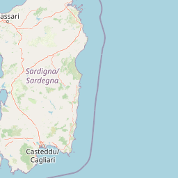
Map view of Laguna di Marceddì

Use this park location map to pinpoint Laguna di Marceddì in Italy, understand its exact geographic position, and read its mapped placement within the surrounding landscape more clearly.

Pigeon | © OpenStreetMap contributors

Location context for Laguna di Marceddì

Sardinia

Photographic records of tidal flats, brackish waters, and protected habitats in Sardinia

Laguna di Marceddì Landscape and Scenery: Visualizing the Coastal Wetland

Visual documentation captures the shallow basins, tidal channels, and characteristic brackish waters defining the protected coastal geography of Laguna di Marceddì. Photographic records reveal the interplay between delicate waterbird habitats and traditional working landscapes along the western Sardinian coast.

A wide view of a calm lagoon with a small fishing boat anchored in the left foreground and a distant shoreline with buildings in the background under a clear sky.

Park atlas

Compare adjacent coastal wetlands and regional Mediterranean habitats

Parks Near Laguna di Marceddì and Surrounding Protected Areas

Browse protected areas and wetland reserves located near Laguna di Marceddì along the western Sardinian coast. Regional park comparison reveals connected coastal ecosystems, brackish water basins, and adjacent conservation landscapes.
A soft watercolor illustration depicting a calm wetland scene with distant hills, a mirror-like water surface, and reeds in the foreground.
Protected areaSardegna
About 2.7 km away#1 closest

Southeast

Stagno di San Giovanni: Protected Coastal Wetland Geography and Regional Landscape Atlas

Brackish lagoon habitats in the province of Oristano, Sardegna

Explore the natural terrain of Stagno di San Giovanni, a brackish coastal lagoon in southwestern Sardegna. Defined by shallow waters and river-fed marshlands, this protected area is central to an interconnected network of Mediterranean lagoons, offering significant insight into the coastal geography and environmental history of the Oristano region.

Area
7 km²
Relief
Lowland
Scope
Terrestrial
Water
Water-dominated
Watercolor painting of a mountainous landscape with green forests and distant hills
National parkItaly
About 76 km away#2 closest

Northeast

National Park of the Gulf of Orosei and Gennargentu: Italy's Coastal and Mountain Protected Terrain

Mapped geography of a unique Sardinian protected landscape.

Delve into the atlas-level details of the National Park of the Gulf of Orosei and Gennargentu, a protected area in Italy renowned for its stark contrast between dramatic coastal cliffs bordering the Gulf of Orosei and the wild, mountainous interior of the Gennargentu massif. This page provides structured geographic context, mapping the park's boundaries and showcasing its distinctive karst landscape, hidden beaches, and rugged peaks for comprehensive protected-area exploration.

IUCN
II
Marine protected areaFrance
About 123 km away#3 closest

North

Sanctuaire Pelagos Marine Protected Area: Mediterranean Geography and Seascape

A transboundary conservation zone spanning 87,500 square kilometers.

Sanctuaire Pelagos represents a unique collaborative effort in marine conservation across the Mediterranean. Spanning the waters between France, Italy, and Monaco, this protected maritime area is defined by its deep-sea canyons and nutrient-rich currents that sustain diverse cetacean populations. Its immense scale and international governance make it a focal point for understanding Mediterranean marine biodiversity and environmental policy.

Area
87,500 km²
Established
1999
IUCN
IV
Relief
Lowland
Watercolor illustration of a coastal landscape with green hills, shoreline, and blue sea under a pale yellow sky
National parkSardinia
About 143 km away#4 closest

North

Asinara National Park: National Park Protected Landscape and Geographic Setting

Explore mapped terrain and protected area context within Sardinia.

Asinara National Park stands as a key protected landscape within the Italian national park system, located off the coast of Sardinia. This entry provides detailed geographic context, focusing on its mapped boundaries and the unique natural terrain that defines this island sanctuary. MoriAtlas facilitates a structured discovery of Asinara National Park, enabling users to understand its protected area status and its significant position within the broader regional geography of Sardinia for atlas exploration.

Area
51.7 km²
Established
1997
IUCN
II
Relief
Mixed relief
National parkItaly
About 173 km away#5 closest

Northeast

Arcipelago di La Maddalena National Park: An Italian National Park Defined by Archipelago Geography

Discover mapped protected boundaries and regional landscape context.

Arcipelago di La Maddalena National Park stands as a vital protected area within Italy, characterized by its distinctive archipelago geography. This national park offers a unique lens through which to explore mapped natural landscapes, understand protected land distribution, and contextualize its regional geographic significance. Dive into the detailed mapping of its protected territories to appreciate the full scope of this significant natural asset for structured atlas discovery.

Area
201.46 km²
Established
1994
IUCN
II
Relief
Lowland
National parkBizerte Governorate
About 292 km away#6 closest

South

Jebel Chitana-Cap Négro National Park: National Park Protected Area & Landscape Identity

Explore the mapped geography of Jebel Chitana-Cap Négro National Park.

As a designated national park, Jebel Chitana-Cap Négro National Park represents a key protected area for understanding the regional geography of Bizerte Governorate. This entry provides structured information focused on the park's geographic scope, its mapped boundaries, and its significance as a protected landscape. It is designed for users seeking detailed, atlas-style context on Jebel Chitana-Cap Négro National Park's natural setting and its place within Tunisia's protected lands network.

Area
101.2 km²
Established
2010
Relief
Mountain
Scope
Terrestrial
National parkTunisia
About 295 km away#7 closest

South

Ichkeul National Park: Tunisia's Key Protected Landscape for Geographic Discovery

Explore the mapped geography and regional context of this Tunisian national park.

Ichkeul National Park is a crucial protected area located in Tunisia, offering a distinct focal point for geographic exploration and atlas-based understanding. This park's mapped boundaries and protected status are central to appreciating its role within Tunisia's natural landscapes and the wider North African region. Through structured data and detailed geographic context, users can gain insight into Ichkeul National Park's unique environmental identity and its significance as a protected natural resource.

Biosphere reserveCorse
About 306 km away#8 closest

North

Vallée du Fango Biosphere Reserve: Geography and Protected Landscape Analysis

Mapping the natural features of the Corse watershed.

Vallée du Fango encompasses a significant protected watershed in western Corse. This reserve features a complete altitudinal gradient, ranging from Laricio pine-forested summits to a thriving coastal estuary. The site is characterized by exceptionally clear water, centuries-old holm oak woodland, and complex riparian systems that define the natural geography of this Mediterranean drainage basin.

Area
251.1 km²
Established
1977
Relief
Mountain
Climate
Mediterranean

Common questions about visiting, size, designation, and location context for Laguna di Marceddì

Laguna di Marceddì FAQs for park facts, access, geography, and protected area context

Find quick answers about Laguna di Marceddì, including protected-area facts, park geography, trail and visitor context, and how the park fits into its surrounding country and regional landscape.
MoriAtlas Explorer

Continue Your Protected Areas Search Across the Global Atlas

Deepen your exploration by continuing the structured search for national parks and protected areas worldwide. Utilize the comprehensive filtering capabilities to compare different conservation landscapes and refine your understanding of global park geography. Discover more about the distribution and characteristics of protected natural areas.

Global natural geography