Mori Atlas logo
National parkIchkeul National Park

Discover the mapped boundaries and regional context of Ichkeul National Park within Tunisia's geography.

Ichkeul National Park: Tunisia's National Park Protected Landscape Identity and Geography

(Parc National de l'Ichkeul)

Ichkeul National Park stands as a significant protected landscape within Tunisia, offering a unique lens into the nation's natural geography and conservation efforts. As a designated national park, its boundaries and environmental characteristics are mapped to provide context for its role in the broader atlas of protected areas. This page delves into the specific geographic identity of Ichkeul National Park, highlighting its position within the North African region and its importance for understanding the distribution of protected lands.

wetlandbirdwatchingmigratory birds Ramsar siteMediterranean ecosystemprotected area

Ichkeul National Park

National park

Park overview

Structured park overview, official facts, and landscape profile for Ichkeul National Park

Ichkeul National Park park facts, protected area profile, and essential visitor context

Review the core facts for Ichkeul National Park, including designation, size, terrain, visitor scale, habitats, and operating context in one park-focused overview.

About Ichkeul National Park

Ichkeul National Park protects a remarkable wetland ecosystem in the Mediterranean basin. The park's central feature, Lake Ichkeul, is a shallow, endorheic lake that undergoes significant seasonal variation in water level and salinity. During the winter months, the lake fills with fresh water from surrounding wadis, creating ideal conditions for waterfowl. In summer, the water recedes and becomes more saline as the lake dries partially. This dynamic cycle supports a complex ecological community that has evolved to thrive in fluctuating conditions. The park extends beyond the lake to include riparian forests, marshlands, and rolling hills covered in cork oak and eucalyptus. The wetland's international significance stems from its position along the East Atlantic Flyway, one of the major migratory bird routes in the Western Hemisphere. Each year, the park hosts enormous numbers of ducks, including tens of thousands of diving ducks that winter here, making it one of the most important wetland sites in Africa for waterfowl. The surrounding agricultural landscape and traditional land use practices have shaped the area for centuries, creating a cultural landscape that complements the natural values.

Quick facts and research context for Ichkeul National Park

Lake Ichkeul is the largest lake in Tunisia, covering approximately 126 square kilometers at full capacity. The park is located in the Bizerte Governorate of northern Tunisia, near the Algerian border. It features a mix of freshwater and brackish ecosystems, with seasonal flooding that creates ideal conditions for waterfowl. The park supports over 200 bird species, including significant populations of ducks, grebes, and herons.

Protection and recognition

Global conservation status and international treaty frameworks governing the lake basin.

Ichkeul National Park Protection Status and Global Conservation Designations

Geographic records trace the official boundary management and international status of Ichkeul National Park as a critically designated ecological zone. Reviewing documented designations like its UNESCO World Heritage status, Ramsar site enrollment, and Biosphere Reserve registry provides essential regional context for conservation analysis.

International recognition

Protection details

Designated year
1977
Core area
74.53 km²
Buffer area
45.16 km²
Park context

Deeper park guide and search-rich context for Ichkeul National Park

Ichkeul National Park history, landscape, wildlife, and travel context

Explore Ichkeul National Park through its history, landscape character, ecosystems, wildlife, conservation priorities, cultural context, and seasonal travel timing in a structured park guide built for atlas discovery and search intent.

Why Ichkeul National Park stands out

Ichkeul National Park is best known as a major migratory bird sanctuary, serving as a crucial resting and feeding ground for hundreds of thousands of birds traveling between Europe and sub-Saharan Africa. The lake's seasonal changes create rich feeding grounds that attract spectacular congregations of ducks, particularly the ruddy duck and pochard, as well as greater flamingos, purple herons, and white storks. The park's combination of open water, reed beds, and surrounding forested hills makes it one of the most biodiverse areas in Tunisia.

Ichkeul National Park history and protected-area timeline

Ichkeul National Park was established in 1980, formalizing protection for what had long been recognized as an ecologically significant area. The park's creation came amid growing international awareness of the need to protect migratory bird habitats and wetland ecosystems. Prior to national park designation, the lake and surrounding areas had been used for fishing, grazing, and agriculture, activities that continued to some degree within the park boundaries. The Tunisian government designated the area as a national park to balance conservation with sustainable traditional uses. In 1980, the park was also designated as a Ramsar site under the Convention on Wetlands of International Importance, recognizing its global significance as a waterbird habitat. Later, it was added to UNESCO's World Network of Biosphere Reserves, further cementing its international conservation status.

Ichkeul National Park landscape and geographic character

The park encompasses a varied landscape centered on the flat, shallow basin of Lake Ichkeul. The lake occupies a depression between hills to the north and east, with a maximum depth of only a few meters. Surrounding the lake are extensive reed beds and marshes that expand and contract with seasonal water level changes. The western and southern edges of the park feature gentle rolling terrain covered in Mediterranean woodland, with cork oak, eucalyptus, and wild olive trees. The landscape is punctuated by small agricultural plots and traditional settlements where local communities practice farming and livestock grazing. The panoramic views from the hills surrounding the lake offer sweeping vistas across the wetlands, particularly during winter when water levels are highest and bird congregations are most visible.

Ichkeul National Park ecosystems, habitats, and plant life

The ecological character of Ichkeul is defined by its dynamic wetland system. The lake's mix of fresh and brackish water supports diverse aquatic vegetation and provides ideal conditions for fish, which in turn sustain the large bird populations. The surrounding marshes feature extensive beds of common reed and emergent vegetation that provide nesting habitat and cover for waterbirds. The forested hills surrounding the wetland add another habitat layer, supporting terrestrial species including mammals like jackals and red foxes. The seasonal nature of the lake is central to its ecological function: winter rains fill the basin, creating vast areas of shallow water perfect for feeding waterfowl, while summer drying concentrates birds around remaining water bodies. This cycle has made Ichkeul a reliable and productive stop on the migratory route for countless species.

Ichkeul National Park wildlife and species highlights

Ichkeul's wildlife is dominated by its extraordinary bird populations. The lake hosts one of the largest wintering concentrations of ducks in the Mediterranean, with species including the common pochard, tufted duck, red-crested pochard, and ferruginous duck. Greater flamingos feed in the shallower areas, their pink plumage creating a striking visual against the grey-green reed beds. Herons, including the purple heron and little egret, hunt along the water's edge, while white storks and glossy ibis pass through during migration. The surrounding marshes provide breeding habitat for the endemic African subspecies of the purple swamphen. Fish populations in the lake include carp and mullet, which support the bird communities. The terrestrial areas support mammals including jackals, red foxes, and hedgehogs, though these are less frequently observed than the abundant birdlife.

Ichkeul National Park conservation status and protection priorities

Ichkeul National Park represents one of North Africa's most important conservation success stories. The park's dual designation as a Ramsar site and UNESCO Biosphere Reserve reflects its global significance for biodiversity conservation. The protection of this wetland ecosystem helps preserve a critical node in the East Atlantic Flyway, ensuring that migratory birds have safe resting grounds during their seasonal journeys. Conservation challenges include managing water abstraction upstream, which can affect the lake's seasonal water levels, and balancing traditional agricultural uses within the park with wildlife protection. The Tunisian government's management approach emphasizes maintaining the ecological character of the wetland while allowing sustainable traditional uses that have shaped the landscape for generations.

Ichkeul National Park cultural meaning and human context

The Ichkeul region has been inhabited for millennia, with evidence of human activity in the lake basin dating to ancient times. The wetlands have supported local communities through fishing, livestock grazing, and agriculture for generations. Traditional fishing practices continue on the lake, with local fishermen using small boats and traditional methods. The surrounding villages and agricultural landscape reflect centuries of human adaptation to the wetland environment. The area's cultural heritage includes connections to various historical periods, from Punic to Roman and beyond, though the wetland's ecological character remains the defining feature of the region.

Top sights and standout views in Ichkeul National Park

The park's defining highlight is the extraordinary concentrations of migratory waterbirds that gather here each winter, creating one of the most spectacular birdwatching experiences in North Africa. The sight of thousands of ducks rafting on the lake's surface, the pink flash of flamingos taking flight, and the silhouette of white storks perched in dead trees are the park's signature images. The seasonal transformation of the lake, from summer dryness to winter inundation, provides a dynamic backdrop to any visit. The surrounding forested hills offer pleasant walking opportunities with views across the wetlands, while the traditional villages around the park periphery provide glimpses of rural Tunisian life.

Best time to visit Ichkeul National Park

The optimal time to visit Ichkeul National Park is during the winter months, from November through March, when water levels are highest and bird populations are at their peak. This is when the largest numbers of migratory ducks and other waterbirds are present, making for exceptional wildlife viewing. December and January typically offer the best birdwatching conditions as the bird numbers reach their maximum. Summer visits (June to August) are less rewarding as the lake shrinks considerably and many bird species have departed, though the landscape has a different, more stark beauty. Spring migration in April and May can also produce notable bird sightings as passage species move through the region.

Monthly climate preview

Long term average temperature and monthly precipitation data for Tunisia

Ichkeul National Park Climate Normals and Annual Temperature Patterns

Ichkeul National Park records measured monthly temperature variations and precipitation levels across a representative coordinate from 1991 to 2020. Reviewing the complete twelve month climate profile provides detailed historical statistics regarding long term atmospheric patterns.
Annual mean18 °C
11 °C27 °C
Jan11°
Feb11°
Mar13°
Apr15°
May19°
Jun24°
Jul27°
Aug27°
Sep24°
Oct20°
Nov15°
Dec12°
Warmest month
August

27.3 °C

Coolest month
February

10.5 °C

Wettest month
December

2.9 mm/day

Driest month
July

0.2 mm/day

Park location guide

Geography guide, regional context, and park location map for Ichkeul National Park

Ichkeul National Park park geography, regions, and map view in Tunisia

Understand where Ichkeul National Park sits in Tunisia through a broader geographic reading of the surrounding landscape, nearby location context, and its mapped position within the national park landscape.

How Ichkeul National Park fits into Tunisia

Tunisia is a Maghreb country in North Africa with a Mediterranean coastline, bordered by Algeria and Libya. The country features the ancient ruins of Carthage, the Great Mosque of Kairouan, and portions of the Atlas Mountains and Sahara Desert. With a population of approximately 12 million, Tunisia operates as a unitary presidential republic with Arabic as the official language.

Wider geography shaping Ichkeul National Park in Tunisia

Tunisia occupies 163,610 km² in North Africa, bordering Algeria to the west and southwest, Libya to the southeast, and the Mediterranean Sea to the north and east. The country features the eastern end of the Atlas Mountains in the north and extends into the northern Sahara Desert in the south. Its 1,300 km of coastline runs along the Mediterranean Basin. Africa's northernmost point, Cape Angela, is located in Tunisia.

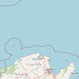
Map view of Ichkeul National Park

Use this park location map to pinpoint Ichkeul National Park in Tunisia, understand its exact geographic position, and read its mapped placement within the surrounding landscape more clearly.

Pigeon | © OpenStreetMap contributors
Natural feature types

Browse the Geographic Landscape Features of Ichkeul National Park

Examine the diverse landforms and water bodies situated across Ichkeul National Park. Use the MoriAtlas collection to identify named features, trace geographic boundaries, and analyze the specific terrain markers that define this protected Tunisian wetland habitat.
Recorded earthquake history

Examine the Historical Earthquake Records Associated with Ichkeul National Park

MoriAtlas provides a structured archive of recorded seismic events associated with the geography of Ichkeul National Park. Review historical data points such as magnitude, date, and epicentre distance to better understand the seismic context of this region in northern Tunisia.

Ichkeul National Park Earthquake History

Catalogued events

7 events

Strongest magnitude

Magnitude 5.1

Most recent event

May 13, 2007

This history includes earthquakes recorded inside the park or within 50 km of its borders

Park atlas

Trace nearby protected landscapes and wetland ecosystems, comparing the regional park geography surrounding Ichkeul National Park.

Discover Other Protected Areas Near Ichkeul National Park and Surrounding Wetland Geography

Explore additional national parks and protected areas, tracing conservation landscapes geographically connected to Ichkeul National Park. Compare diverse wetland ecosystems, regional park geography, and mapped terrain to understand broader protected-area contexts in North Africa.
National parkBizerte Governorate
About 52 km away#1 closest

West

Jebel Chitana-Cap Négro National Park: National Park Protected Area & Landscape Identity

Explore the mapped geography of Jebel Chitana-Cap Négro National Park.

As a designated national park, Jebel Chitana-Cap Négro National Park represents a key protected area for understanding the regional geography of Bizerte Governorate. This entry provides structured information focused on the park's geographic scope, its mapped boundaries, and its significance as a protected landscape. It is designed for users seeking detailed, atlas-style context on Jebel Chitana-Cap Négro National Park's natural setting and its place within Tunisia's protected lands network.

Area
101.2 km²
Established
2010
Relief
Mountain
Scope
Terrestrial
National parkTunisia
About 66 km away#2 closest

Southwest

Oued Zeen National Park: Tunisia's National Park Entry for Geographic and Landscape Atlas Exploration

Explore the mapped protected area and regional geography of Oued Zeen National Park.

Oued Zeen National Park is a designated national park in Tunisia, offering a crucial point for geographic exploration within the country's atlas. This page details its protected landscape identity, contributing to a structured understanding of regional natural areas and park boundaries. Users can examine its geographic setting and landscape context to deepen their appreciation of Tunisia's protected lands.

Area
67 km²
Established
2010
Scope
Terrestrial
Water
Major water bodies
National parkTunisia
About 76 km away#3 closest

Southeast

Boukornine National Park: A Protected Mediterranean Mountain Landscape in Tunisia

Explore its mapped terrain and unique protected ecosystem.

Boukornine National Park in Tunisia represents a significant protected landscape, notable for its central granite peak, Jebel Boukornine, which rises sharply above the surrounding coastal plains. This national park, covering approximately 1,939 hectares, preserves a distinctive Mediterranean mountain ecosystem. Its rugged terrain, rocky slopes, and the presence of Aïn Zargua spring support a unique concentration of species, including notable flora and fauna. Understanding Boukornine National Park provides insight into the regional geography and the importance of conserving these mountainous protected areas within Tunisia.

Area
19.39 km²
Established
1987
IUCN
II
Relief
Mountain
National parkEl Tarf Province
85 km away#4 closest

West

El Kala National Park: Protected Wetlands and Barbary Stag Habitat

Explore its mapped geography and vital ecosystem context.

El Kala National Park represents a crucial protected landscape within El Tarf Province, Algeria, recognized internationally for its extensive Mediterranean wetlands and rich biodiversity. This national park is a vital ecological zone, comprising six major lakes and a significant stretch of coastline, offering a unique mosaic of aquatic and terrestrial environments. Its role as a sanctuary for the Barbary stag and migratory birds highlights its importance in regional conservation efforts. Exploring El Kala National Park provides insight into the mapped terrain, protected boundaries, and distinct geographic features that define this significant North African natural area.

Area
764 km²
Established
1993
IUCN
II
Visitors
30K annual
National parkJendouba Governorate
About 91 km away#5 closest

Southwest

El Feidja National Park: National Park Mapping and Protected Landscape Discovery

Explore geographic context within Jendouba Governorate.

Gain a clear understanding of El Feidja National Park's protected status and its geographic footprint. This page offers detailed insights into the park's mapped boundaries and landscape characteristics, situated within the Jendouba Governorate. It serves as a primary resource for atlas exploration, highlighting the natural terrain and regional significance of this Tunisian national park.

Area
27.65 km²
Established
1990
IUCN
II
Relief
Mountain
National parkTunisia
About 93 km away#6 closest

East

Zembra National Park: A Protected Island Landscape in Tunisia's Mediterranean Waters

Explore its unique geography and mapped protected area boundaries.

Zembra National Park safeguards a rugged, mountainous island environment characterized by dramatic limestone cliffs plunging into the Mediterranean Sea. This national park is renowned for its exceptional avian populations, including the endangered Eleonora's falcon, and its preserved Mediterranean maquis ecosystem, supporting endemic plant species. The park's geographic isolation contributes to its status as a significant biodiversity hotspot, offering a distinct lens for understanding island ecosystems and conservation efforts within the broader Tunisian geography.

IUCN
II
National parkTunisia
About 128 km away#7 closest

South

Jebel Serj National Park: Central Tunisia's Distinctive Mountain Protected Area

Explore its terrain and protected landscape context.

Jebel Serj National Park, established in 2010, safeguards a significant mountainous territory in central Tunisia, distinguishing itself from the broader semi-arid plains. This protected landscape showcases the Djebel Serj massif, a unique topographical feature that serves as an ecological bridge between Tunisia's northern and southern regions. Users exploring this page can gain an atlas-level understanding of the park's mapped boundaries, its geological character, and its contribution to the conservation of representative natural diversity within North Africa's transitional ecosystems.

Area
17.2 km²
Established
2010
IUCN
II
Scope
Terrestrial
Watercolor painting of a landscape with rolling hills, pink wildflowers, and scattered trees
National parkItaly
197 km away#8 closest

East

Pantelleria National Park: A Protected Landscape within Italy's Atlas

Mapped boundaries and regional geographic context.

Pantelleria National Park is a designated national park in Italy offering a distinct protected landscape for exploration. This page provides essential geographic context, highlighting the park's mapped boundaries and its significance within the regional atlas. Understand the terrain and protected land features that define this important natural area.

Area
66.4 km²
Established
2016
IUCN
II
Relief
Highland

Common questions about visiting, size, designation, and location context for Ichkeul National Park

Ichkeul National Park FAQs for park facts, access, geography, and protected area context

Find quick answers about Ichkeul National Park, including protected-area facts, park geography, trail and visitor context, and how the park fits into its surrounding country and regional landscape.
MoriAtlas Explorer

Continue Your Protected Areas Search Across the Global Atlas

Deepen your exploration by continuing the structured search for national parks and protected areas worldwide. Utilize the comprehensive filtering capabilities to compare different conservation landscapes and refine your understanding of global park geography. Discover more about the distribution and characteristics of protected natural areas.

Global natural geography