

Mori Atlas logo
National parkLaiwangi Wanggameti National Park

Discover the geographic identity and park boundaries of this key national park in Indonesia.

Laiwangi Wanggameti National Park: A Mapped Protected Landscape on Sumba

(Taman Nasional Laiwangi Wanggameti)

Laiwangi Wanggameti National Park represents a significant protected area on the island of Sumba, Indonesia. As a designated national park, its mapped boundaries define a crucial component of the region's natural geography. This page provides detailed atlas-style context, helping users understand the park's landscape characteristics and its placement within the broader Sumba region for focused geographic exploration.

National ParkIndonesiaIsland ConservationEndemic SpeciesBirdwatchingTropical Forest

Laiwangi Wanggameti National Park

National park

Park overview

Structured park overview, official facts, and landscape profile for Laiwangi Wanggameti National Park

Laiwangi Wanggameti National Park park facts, protected area profile, and essential visitor context
Review the core facts for Laiwangi Wanggameti National Park, including designation, size, terrain, visitor scale, habitats, and operating context in one park-focused overview.

About Laiwangi Wanggameti National Park

Laiwangi Wanggameti National Park represents one of Indonesia's important protected areas for island biodiversity conservation. Located on Sumba, an island in the Lesser Sunda archipelago, the park encompasses diverse terrain ranging from rolling hills to deep valleys and mountainous peaks including Mount Wanggameti. The park's establishment in 1998 reflected growing recognition of Sumba's ecological significance and the need to protect its unique assemblages of flora and fauna from development pressures and habitat loss. The park serves as the comprehensive representation of Sumba's forest ecosystems within a protected area, making it essential for understanding and preserving the island's ecological character. Visitors can experience the park through jungle exploration and mountain trekking, with viewpoints at Nangga Village, Wanggameti Village, Katikuwai Highlands, and the summit of Mount Wanggameti offering panoramic views of the park's distinctive landscape.

Quick facts and research context for Laiwangi Wanggameti National Park

Laiwangi Wanggameti National Park occupies 470.14 square kilometers on Sumba Island in eastern Indonesia. The park was officially established in 1998 through Indonesian Ministry of Forestry decision No. 576/Kpts-II/1998. It encompasses all major forest types present on Sumba, from lowland vegetation to montane elfin forests. The park is administered by Indonesia's Ministry of Environment and Forestry and is categorized as IUCN protected area management Type II. The nearest major town is Waingapu, the capital of East Sumba Regency, which serves as the primary access point for visitors.

Park context

Deeper park guide and search-rich context for Laiwangi Wanggameti National Park

Laiwangi Wanggameti National Park history, landscape, wildlife, and travel context
Explore Laiwangi Wanggameti National Park through its history, landscape character, ecosystems, wildlife, conservation priorities, cultural context, and seasonal travel timing in a structured park guide built for atlas discovery and search intent.

Why Laiwangi Wanggameti National Park stands out

Laiwangi Wanggameti is best known for its exceptional endemism and the preservation of Sumba Island's unique forest ecosystems. The park protects significant populations of endemic bird species including the Sumba green pigeon, Sumba buttonquail, citron-crested cockatoo, and apricot-breasted sunbird. The elfin forest ecosystem found above 800 meters is particularly rare and ecologically significant. The park also contains ancient carved burial sites with intricate motifs depicting horses, buffalo, and human figures, representing traditional Sumba cultural heritage embedded within the natural landscape.

Laiwangi Wanggameti National Park history and protected-area timeline

The history of scientific exploration of Laiwangi Wanggameti and Sumba Island is well documented through ornithological surveys spanning centuries. Early bird exploration began in the mid-18th century, with significant contributions from researchers including Fraser, who in 1844 named the citron-crested cockatoo (Cacatua sulphurea citrinocristata), and Bonaparte, who in 1853 described Larius roratus cornelia. These early studies demonstrated that European scientists had been studying Sumba's unique avifauna more than a century before Indonesian independence. Ernst Mayr conducted the last pre-independence bird survey in 1944, documenting 121 bird species on Sumba. After Indonesian independence in 1949, researcher E.S. Sutter led an expedition to Sumba, though no ornithologists conducted work on the island for the following three decades. Bird surveys resumed in 1979 under Joh MacKinnon, who systematically documented the species present and contributed to understanding the park's ecological significance.

Laiwangi Wanggameti National Park landscape and geographic character

The landscape of Laiwangi Wanggameti National Park features a dramatic combination of steep ridgelines, deep valleys, and elevated plateaus characteristic of Sumba Island's terrain. The park's topography includes the prominent peak of Mount Wanggameti and the Katikuwai Highlands, which offer sweeping vistas across the protected area. The landscape transitions from lower elevation forest through increasingly stunted vegetation as elevation rises, culminating in the rare elfin forest zone above 800 meters where microclimate conditions support specialized plant communities. The blend of multiple ecosystem types with rolling hills and steep valleys creates an exotic panorama distinctive to this protected area. Several notable water features punctuate the landscape including Lake Laputih, Laputi Waterfall, Waikanabu Waterfall, and Wanggameti Waterfall, which add to the park's scenic diversity.

Laiwangi Wanggameti National Park ecosystems, habitats, and plant life

The nature of Laiwangi Wanggameti centers on Sumba Island's unique ecological assemblages, which have evolved in relative isolation producing significant endemism. The park contains all forest types present on Sumba, making it the definitive protected area for the island's vegetation. The elfin forest at higher elevations represents a particularly rare habitat in the Nusa Tenggara region, hosting species with specialized adaptations to cooler, cloudier conditions. The park protects numerous endemic plant species including various Syzygium species, Alstonia scholaris (pulai), Ficus species, Canarium oleosum (kenari), Cinnamomum zeylanicum (cinnamon), Myristica littoralis (honggi), Toona sureni (suren), Sterculia foetida (taduk), Schleichera oleosa (kesambi), and Palaquium obovatum (hangkang). Butterfly diversity is remarkable, with 43 species documented including five endemic to Nusa Tenggara.

Laiwangi Wanggameti National Park wildlife and species highlights

The wildlife in Laiwangi Wanggameti reflects Sumba Island's position as a center of endemism within Indonesia. The park protects diverse mammal species including the crab-eating macaque (Macaca fascicularis), various wild pig (Sus species), and the water monitor lizard (Varanus salvator). Reptiles include the Timor python (Python timoriensis) and diverse snake species. The avifauna is particularly significant, featuring endemic species such as the Sumba green pigeon (Treron teysmannii), Sumba buttonquail (Turnix everetti), citron-crested cockatoo (Cacatua sulphurea citrinocristata), purple-naped lory (Lorius domicella), Sumba flycatcher (Ficedula harterti), Sumba cicadabird (Coracina dohertyi), and apricot-breasted sunbird (Nectarinia buettikoferi). The red junglefowl (Gallus gallus) represents the wild ancestor of domestic chickens and occurs within the park. The Sumba buttonquail and Sumba green pigeon are particularly notable as restricted-range endemics.

Laiwangi Wanggameti National Park conservation status and protection priorities

Laiwangi Wanggameti serves critical conservation functions as the primary protected area preserving Sumba Island's unique biodiversity. The park's designation as IUCN Category II reflects its national park status and the priority placed on ecosystem preservation. The protection of all Sumba forest types within a single protected area ensures conservation of the complete range of island ecosystems from lowland to montane zones. The elfin forest above 800 meters receives particular protection as a rare habitat type with high species diversity. Conservation of endemic plant species such as those in the genus Syzygium, Ficus, and other families maintains genetic resources and ecosystem functions. The bird species, many of which are endemic to Sumba or Nusa Tenggara, depend on the park for habitat preservation.

Laiwangi Wanggameti National Park cultural meaning and human context

Laiwangi Wanggameti contains significant cultural heritage embedded within its natural landscape. Around the park are numerous ancient burial sites featuring intricate carvings depicting horses, buffalo, and human figures in traditional Sumba motifs. These stone tombs represent social status and cultural identity of the families they commemorate, reflecting the deep connection between Sumba's traditional societies and the landscape. The park encompasses villages including Nangga, Wanggameti, Tana Rara, and Tabundung where local communities maintain traditional land stewardship practices. The combination of natural and cultural values creates a landscape where ecological preservation intersects with cultural heritage conservation.

Top sights and standout views in Laiwangi Wanggameti National Park

The highlights of Laiwangi Wanggameti include its exceptional birdlife with numerous Sumba endemics, the rare elfin forest ecosystem above 800 meters, dramatic hilly and valley terrain with panoramic viewpoints, and cultural sites including ancient carved burial grounds. The park offers jungle trekking and mountain climbing experiences, with Mount Wanggameti providing summit views across the protected landscape. Waterfalls including Laputi, Waikanabu, and Wanggameti add scenic variety, while Lake Laputih offers another natural attraction. The combination of all Sumba forest types in one protected area makes it essential for understanding the island's ecology.

Best time to visit Laiwangi Wanggameti National Park

The best time to visit Laiwangi Wanggameti National Park is during the dry season months of March through June and again from October through December each year. These periods generally offer more favorable conditions for outdoor activities including trekking and wildlife observation. The dry season provides clearer skies and more accessible trail conditions, though visitors should be prepared for variable weather typical of tropical environments. The shoulder seasons offer a balance between favorable conditions and fewer visitors, though the exact timing of seasons may vary year to year.

Park location guide

Geography guide, regional context, and park location map for Laiwangi Wanggameti National Park

Laiwangi Wanggameti National Park park geography, regions, and map view in Indonesia
Understand where Laiwangi Wanggameti National Park sits in Indonesia through a broader geographic reading of the surrounding landscape, nearby location context, and its mapped position within the national park landscape.

How Laiwangi Wanggameti National Park fits into Indonesia

Indonesia is a vast archipelagic nation in Southeast Asia and Oceania, spanning over 17,000 islands between the Indian and Pacific Oceans. As the world's fourth-most populous country with 288 million people, it features extraordinary cultural and biological diversity, withJavanese and Sundanese being the largest ethnic groups. The country gained independence from the Netherlands in 1945 and operates as a unitary presidential republic.

Wider geography shaping Laiwangi Wanggameti National Park in Indonesia

Indonesia is situated in Southeast Asia and Oceania, spanning the equatorial region between the Indian Ocean to the west and the Pacific Ocean to the east. The archipelago includes major islands such as Sumatra, Java, Sulawesi, and parts of Borneo and New Guinea. It borders Papua New Guinea, Timor-Leste, and Malaysia by land, with extensive maritime boundaries throughout the region.

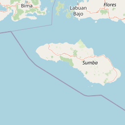
Map view of Laiwangi Wanggameti National Park

Use this park location map to pinpoint Laiwangi Wanggameti National Park in Indonesia, understand its exact geographic position, and read its mapped placement within the surrounding landscape more clearly.

Pigeon | © OpenStreetMap contributors

Location context for Laiwangi Wanggameti National Park

East Nusa TenggaraSumba
Park atlas

Trace the geographic spread of Indonesia's protected areas, comparing unique island ecosystems across Sumba and Eastern Indonesia.

Explore Other National Parks and Protected Areas Near Laiwangi Wanggameti National Park
Discover additional national parks and protected areas across Sumba Island's diverse terrain and the broader Eastern Indonesia region, building on your exploration of Laiwangi Wanggameti National Park. This enables a detailed atlas comparison of varied island ecosystems, endemic biodiversity, and regional protected landscapes.
National parkEast Nusa Tenggara

Manupeu Tanah Daru National Park: National Park Protected Landscape and East Nusa Tenggara Geography

Discover its mapped boundaries and regional atlas context.

Delve into the protected landscape of Manupeu Tanah Daru National Park, a significant national park situated within East Nusa Tenggara. This dedicated page provides detailed geographic context, focusing on the park's mapped boundaries and its contribution to the regional natural landscape. Understand its identity as a protected area and explore its place within the broader atlas of global conservation lands, fostering a deeper appreciation for its distinct geographic characteristics.

Area
879.84 km²
Established
1998
IUCN
II
Relief
Lowland
National parkEast Nusa Tenggara

Komodo National Park: National Park Protected Landscape Atlas Entry

Mapped boundaries and regional geography for this Indonesian protected area.

Delve into the atlas representation of Komodo National Park, an essential protected landscape within the East Nusa Tenggara region of Indonesia. This entry highlights the park's mapped boundaries and its distinctive geographic setting. Understand the park's role as a national park and its contribution to the structured exploration of protected areas and natural landscapes across the Lesser Sunda Islands.

Area
1,733 km²
Established
1980
IUCN
II
Visitors
45K annual
National parkEast Nusa Tenggara

Kelimutu National Park: Volcanic Terrain and Colored Crater Lakes in East Nusa Tenggara

Explore the mapped geography of this unique Indonesian national park.

Kelimutu National Park represents a remarkable protected landscape in East Nusa Tenggara, Indonesia, distinguished by its volcanic origins and the famed three colored lakes of Mount Kelimutu. This national park protects diverse montane forests and offers a unique insight into the region's geological wonders. Its geography features volcanic slopes and the iconic caldera, making it a significant point of interest for atlas-driven exploration of protected natural areas.

Area
50 km²
Established
1992
IUCN
II
Visitors
12.5K annual
National parkSouth Sulawesi

Bantimurung-Bulusaraung National Park: National Park Protected Landscape Identity and Geographic Setting

Mapped boundaries and regional atlas context for this South Sulawesi park.

Bantimurung-Bulusaraung National Park is an important protected area in South Sulawesi, Indonesia, designated as a national park. This entry provides a focused look at its geographic scope, mapped outlines, and the characteristics that define it as a protected landscape. Understanding this park's specific terrain and regional setting is key to appreciating its role within the broader atlas of natural areas and conservation efforts.

Area
437 km²
Established
2004
IUCN
II
Visitors
600K annual
National parkEast Java

Alas Purwo National Park: A Protected Landscape within East Java's Geography

Mapped natural terrain and national park status in East Java.

Delve into the atlas-specific details of Alas Purwo National Park, a key protected area located in the East Java region of Indonesia. This page focuses on its identity as a national park, highlighting its geographic significance and the value of its mapped landscape for structured discovery. Understand the context of this protected land within the broader geography of East Java, contributing to a comprehensive overview of Indonesia's conservation territories.

Area
434.2 km²
Established
1992
IUCN
II
Visitors
14.7K annual
National parkSouth East Sulawesi

Rawa Aopa Watumohai National Park: Geographic Atlas and Protected Landscape Overview

Explore Rawa Aopa Watumohai National Park's mapped boundaries.

Gain a clear understanding of Rawa Aopa Watumohai National Park, a designated national park in South East Sulawesi. This entry offers insight into its protected landscape identity, mapped geographic features, and its specific location within the regional atlas. It serves as a focused point for comprehending the park's protected area context and its contribution to Indonesian natural geography.

Area
1,050 km²
Established
1989
IUCN
II
Relief
Mixed relief
National parkEast Java

Meru Betiri National Park: Mapped Protected Landscape in East Java

Discover the terrain and geography of this national park.

Meru Betiri National Park in East Java, Indonesia, offers a rich tapestry of mapped landscapes, from its distinctive sandy beaches and mangrove ecosystems along the southern coast to its interior volcanic highlands and tropical rainforests. This protected area is crucial for understanding the regional geography and the distribution of conservation lands across Java. Explore its topographic diversity and unique ecological settings that define this significant national park.

Area
580 km²
Established
1982
IUCN
II
Visitors
2.5K annual
National parkWest Sulawesi

Gandang Dewata National Park: Protected Area Identity and Geographic Context in West Sulawesi

Explore mapped boundaries and regional landscape.

Delve into the protected landscape of Gandang Dewata National Park, a key national park situated in West Sulawesi. This resource offers a detailed geographic perspective, emphasizing its mapped boundaries and its position within the regional atlas. Understand the park's protected-area status and its contribution to the natural geography of Indonesia, serving as a vital point for atlas exploration.

Area
793.42 km²
Established
2016
IUCN
II
Relief
Mountain

Common questions about visiting, size, designation, and location context for Laiwangi Wanggameti National Park

Laiwangi Wanggameti National Park FAQs for park facts, access, geography, and protected area context
Find quick answers about Laiwangi Wanggameti National Park, including protected-area facts, park geography, trail and visitor context, and how the park fits into its surrounding country and regional landscape.
MoriAtlas Explorer

Continue Your Protected Areas Search Across the Global Atlas

Deepen your exploration by continuing the structured search for national parks and protected areas worldwide. Utilize the comprehensive filtering capabilities to compare different conservation landscapes and refine your understanding of global park geography. Discover more about the distribution and characteristics of protected natural areas.

Global natural geography