

Mori Atlas logo
Protected areaLake Chilwa

Trace the shifting shoreline, endorheic basin geography, and seasonal floodplains of this critical Ramsar wetland habitat.

Lake Chilwa Protected Area: Mapping the Dynamic Wetland Landscape of Zomba District, Malawi

Lake Chilwa occupies a unique endorheic basin in Zomba District, where seasonal rainfall drives dramatic shifts in water levels and surface area. This protected area supports a vast network of flooded grasslands and riverine channels that link the Shire Highlands to the lake basin. By examining the mapped boundaries and natural terrain, users gain a clear perspective on how the lake, Chisi Island, and surrounding wetlands function within the broader geography of southeastern Malawi.

endorheic lakefreshwater lakewetlandRamsar siteZambezian flooded grasslandswaterbirds
A flat-style digital illustration showing small boats moored on the green grassy bank of a calm lake with distant hills and a soft pastel sunset sky.

Lake Chilwa

Protected area

Park overview

Structured park overview, official facts, and landscape profile for Lake Chilwa

Lake Chilwa park facts, protected area profile, and essential visitor context

Review the core facts for Lake Chilwa, including designation, size, terrain, visitor scale, habitats, and operating context in one park-focused overview.

About Lake Chilwa

Lake Chilwa is a large but shallow inland lake in eastern Malawi, occupying a broad depression in Zomba District close to the border with Mozambique. It is the second-largest lake in the country after the Great Rift Valley lake that bears the country's name, and its hydrology is shaped by an enclosed basin, seasonal rivers, and a tropical climate with a strong wet season.

The lake covers an area of roughly 60 km by 40 km at its fullest extent, although that picture is constantly shifting. The principal rivers feeding it, including the Naisi, Thondwe, Phalombe, Songani, and Domasi, drain the surrounding highlands and deliver most of the water during the rainy season, while intense summer evaporation recycles it back to the atmosphere. Because Lake Chilwa has no permanent outflow, even severe multi-year droughts can dramatically shrink the lake, and in 1968 the basin effectively dried out during an exceptional dry spell. Historical travelers, including David Livingstone in 1859, described a much larger lake than the one seen today, suggesting that long-term climate and land-use shifts are continuously reshaping its shoreline.

Ecologically, the lake and its surrounding low-lying flats form part of the broader Zambezian flooded grasslands, a mosaic of seasonal marshes, reed beds, open water, and floating vegetation that pulses between wet and dry phases through the year. These conditions support extremely high densities of waterbirds, including large populations of migratory species that travel along the Asian to East African Flyway. Lake Chilwa is also at the heart of a dense human landscape, with roughly 335 villages along its shores supporting a major inland fishery. The combination of ecological richness, hydrological sensitivity, and heavy human dependence on its resources gives Lake Chilwa a profile quite distinct from that of Malawi's larger Rift Valley lakes, and has shaped international efforts to safeguard it.

Quick facts and research context for Lake Chilwa

Lake Chilwa is a shallow, endorheic lake in eastern Malawi, second in size only to Lake Malawi, and it sits near the Mozambique border in Zomba District. The lake measures roughly 60 km long and 40 km wide at its broadest extent, though its area fluctuates strongly with rainfall and evaporation.

No permanent outflow connects the lake to the sea, so its water balance is governed entirely by inflowing rivers such as the Naisi, Thondwe, Phalombe, Songani, and Domasi, by direct rainfall, and by evaporation. A Ramsar site since 1996, Lake Chilwa is embedded in a wider complex of flooded grasslands and associated wetland habitats that support regionally important bird populations and a major inland fishery.

Protection and recognition

Documented terrestrial designation history and Ramsar site records

Lake Chilwa Protection Status and International Recognition Data

Lake Chilwa maintains documented terrestrial protection status established in 1996 alongside official Ramsar wetland recognition. Verified designation records provide structured baseline facts regarding international conservation frameworks.

International recognition

Protection details

Protection scope
Terrestrial
Designated year
1996
Transboundary protection
No
Park context

Deeper park guide and search-rich context for Lake Chilwa

Lake Chilwa history, landscape, wildlife, and travel context

Explore Lake Chilwa through its history, landscape character, ecosystems, wildlife, conservation priorities, cultural context, and seasonal travel timing in a structured park guide built for atlas discovery and search intent.

Why Lake Chilwa stands out

Lake Chilwa is best known for being one of the most important wetlands in southern Africa, hosting enormous congregations of waterbirds and supporting a major inland fishery. Its designation as a Ramsar site reflects the global significance of its seasonal flooded grasslands and shallow open water. The lake is equally recognized for its dramatic water-level fluctuations. Because Lake Chilwa has no outflow, its shoreline and surface area change markedly between wet and dry years, and in extreme droughts the basin has been known to almost disappear. This dynamic hydrology shapes every aspect of the lake, from fish stocks and birdlife to the livelihoods of the surrounding villages.
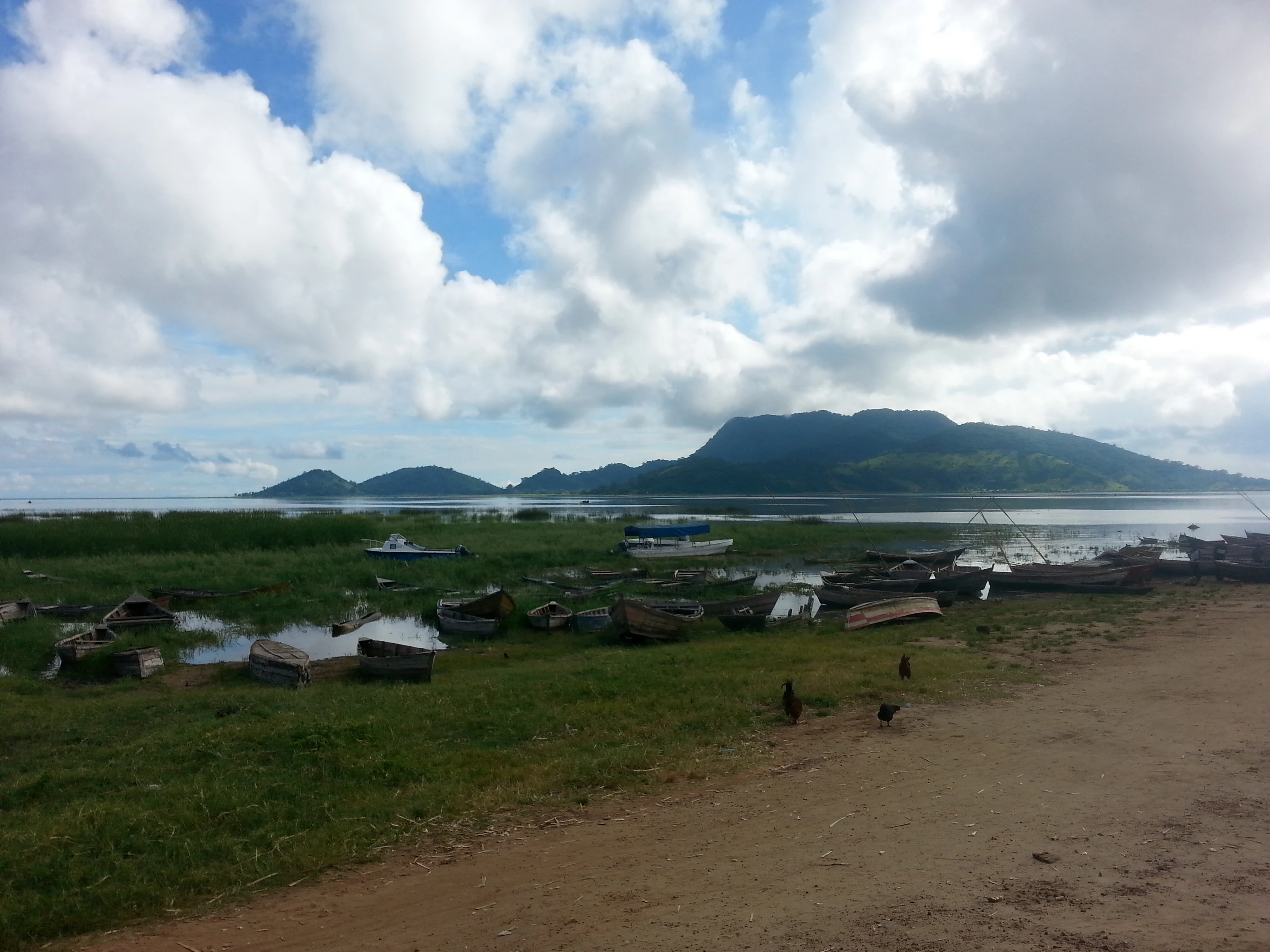
A wide view of the grassy shore of Lake Chilwa with small wooden fishing boats moored in shallow water, and a large hill, likely Chisi Island, rising in the background under a cloudy sky.
Western shore of Lake Chilwa with Chisi Island visible in the distance.

Lake Chilwa history and protected-area timeline

Lake Chilwa has long been important to people living in southeastern Malawi. When the Scottish explorer David Livingstone reached the lake in 1859, he recorded that its southern shoreline extended close to the Mulanje Massif, implying that in the mid-nineteenth century the lake was substantially larger than its present footprint. Historical accounts and paleoclimate evidence together suggest that the basin's extent has fluctuated considerably over time in response to shifting rainfall patterns and land-use change.

In the twentieth century, the lake became a focal point for fisheries, settlement, and conservation. The surrounding wetland complex has supported large numbers of fishing villages for generations, and the lake now contributes a significant share of Malawi's inland fish catch. The most dramatic recorded event in the modern history of Lake Chilwa occurred in 1968, when exceptional drought caused the lake to effectively disappear. This event underscored how vulnerable the basin's hydrology and the communities dependent on it are to climatic extremes.

In response, conservation and development partners have worked to protect the wetland. The lake was formally designated as a Ramsar Wetland of International Importance in the mid-1990s, and international organizations, including the Danish International Development Agency in cooperation with the Government of Malawi, have supported programs to safeguard the lake and its catchment. The Lake Chilwa Basin Climate Change Adaptation Programme has become a key framework for managing the wetland in the face of growing pressure from fishing, agriculture, and a warming climate.

Lake Chilwa landscape and geographic character

Lake Chilwa occupies a broad, shallow basin in southeastern Malawi on the edge of the Zomba plateau and close to the Mozambique border. The surrounding landscape is gently undulating, with higher ground reaching back toward the Shire Highlands to the west and the Mulanje Massif to the south. The lake itself is flat and open, with no strong relief above or below the waterline, and its long, irregular shoreline shifts position as water levels rise and fall.

The basin is enclosed, meaning that water only leaves through evaporation. The principal inflows, the Naisi, Thondwe, Phalombe, Songani, and Domasi rivers, drain the surrounding hills and deliver most of their flow during the rainy season. Their lower courses slow down as they enter the basin and spread into a network of channels, floodplains, and backswamps that blur the boundary between river, marsh, and lake. The result is a wide, soft-edged wetland landscape that can look very different from one season to the next and very different from one decade to the next.

Chisi Island, sitting in the middle of the lake, is one of the few fixed landmarks in a setting that otherwise moves with the rains. When lake levels are high, Chisi appears as an isolated wooded island; when levels drop, it can become more closely connected to the surrounding wetlands or to exposed sediments. Around the lake, villages, cultivated plots, and reed beds form a transitional fringe, with human land use pressing against the remaining natural shoreline in a way that is intimately tied to the lake's seasonal rhythms.

Lake Chilwa ecosystems, habitats, and plant life

Lake Chilwa sits at the heart of one of the most extensive wetland complexes in Malawi, where open water, seasonal marshes, reed beds, and floating vegetation form a mosaic that expands and contracts with the rains. Ecologically, the lake and its floodplain belong to the Zambezian flooded grasslands, a system characterized by periodic inundation, nutrient-rich sediments, and grasses and sedges adapted to alternating wet and dry conditions.

The floodplain supports a layered vegetation pattern. Closer to the open water, rooted and floating aquatic plants dominate; further out, dense beds of reeds and papyrus fringe the shoreline, grading into wet grasslands that are grazed and harvested by local communities. The inflows and outflow channels of the lake create distinct habitat types, from slow-moving channels choked with vegetation to open pools where water levels have temporarily stabilized.

The lake's ecology is driven by its hydrology. The absence of a permanent outflow means that nutrients, salts, and sediments gradually accumulate, and that water chemistry can shift sharply between years. Seasonal flooding resets some of these patterns and creates temporary habitats that are critical for breeding fish and feeding waterbirds. These pulsing conditions are central to why the lake supports such large populations of fish and birds, and to why Lake Chilwa's ecological character remains distinct from that of the deeper Rift Valley lakes further north.

Lake Chilwa wildlife and species highlights

Lake Chilwa is best known for its waterbirds. The lake and its associated wetlands support a population of around 1.5 million waterbirds drawn from roughly 160 species. A significant share of these birds are migratory, traveling between breeding grounds in the northern hemisphere, particularly Siberia, and non-breeding areas in eastern and southern Africa along the Asian to East African Flyway. Lake Chilwa supports internationally important numbers for at least twelve species, each of which accounts for more than one percent of the total flyway population.

Fish are the other cornerstone of the lake's wildlife. Among the most common species are Barbus paludinosus, Oreochromis shiranus chilwae, Clarias gariepinus, Brycinus imberi, and various species of Gnathonemus. These fish underpin one of the largest inland fisheries in Malawi and form the base of a food chain that also supports piscivorous birds. The shallow, productive waters and the pulse of seasonal flooding create ideal spawning and feeding conditions for many of these species.

The relationship between wildlife and people is unusually tight here. Waterbirds are hunted, especially when fish catches decline during low-water periods, and birds are an important local source of protein. This overlap between conservation interests and local livelihoods shapes how wildlife management on Lake Chilwa is approached, and has prompted efforts to promote sustainable hunting practices alongside broader wetland protection.

Lake Chilwa conservation status and protection priorities

Lake Chilwa's conservation significance was formally recognized in 1996 when the lake was designated a Ramsar Wetland of International Importance, placing it among a network of globally important wetlands. The Ramsar designation reflects the lake's role as habitat for waterbirds of international concern and highlights the ecological value of the surrounding Zambezian flooded grasslands, which are increasingly rare across southern Africa.

Conservation efforts have increasingly focused on climate change adaptation. The Lake Chilwa Basin Climate Change Adaptation Programme, supported by the Danish International Development Agency in cooperation with the Government of Malawi, aims to safeguard the lake and its linked wetlands in the face of shifting rainfall patterns, growing demand for fish and farmland, and the competing needs of large numbers of surrounding villages. Programs under this framework typically combine wetland monitoring, sustainable fisheries support, and community engagement, recognizing that the basin's ecological future depends on the decisions of the people who live around it.

Bird hunting is a particular focus. Because waterbirds are taken for food at times when fish catches are poor, management programs have worked to ensure that hunting is carried out sustainably, so that the lake's waterbird populations remain healthy and continue to function as part of broader flyway networks. These efforts underline that Lake Chilwa's conservation is shaped as much by local livelihood dynamics as by external protection regimes.

Lake Chilwa cultural meaning and human context

Lake Chilwa is central to the identity and economy of a densely settled rural landscape in southeastern Malawi. A large number of villages, estimated at roughly 335 communities, ring the lake and depend directly on its fish, its wetland plants, and its seasonal flood-recession agriculture. This long-standing relationship between communities and a shifting, fragile wetland is an important part of the lake's cultural and human context.

The lake also holds a place in the broader history of African exploration. David Livingstone's 1859 visit remains one of the most famous European accounts of the lake, and his descriptions of a much larger historical shoreline continue to inform discussions about how the basin has changed over time. Combined with the lake's recurring appearance in local oral history, this makes Lake Chilwa both a working landscape and a site of regional memory.

Top sights and standout views in Lake Chilwa

Lake Chilwa combines a Ramsar-listed wetland with one of Malawi's largest inland fisheries, making it a rare example of a globally recognized conservation site that is also an everyday working landscape.

Its seasonal pulse, set by tropical rains, intense evaporation, and a closed basin, produces dramatic fluctuations in extent and ecology, including the rare and sobering event in 1968 when the lake effectively disappeared. The presence of Chisi Island at the lake's center, the network of inflowing rivers from the surrounding highlands, and the sheer density of waterbirds drawn from a major international flyway round out a set of qualities that distinguish Lake Chilwa from any other lake in the country.

Best time to visit Lake Chilwa

The character of Lake Chilwa changes dramatically with the seasons, shaped by the tropical rainfall pattern in southern Malawi. The rainy season, broadly from late spring through autumn, raises water levels, expands the open lake, and expands the surrounding flooded grasslands in ways that strongly influence birdlife, fish activity, and accessibility of different parts of the wetland.

The dry season, by contrast, sees water levels fall, exposing more shoreline and concentrating birds and fish in shrinking areas of open water and wetland. This can make wildlife easier to observe but can also reflect the more stressed conditions that the lake sometimes experiences during prolonged drought. Visitors interested in seeing a broad, flooded wetland should generally look to the wetter months, while those interested in concentrated bird flocks and a more exposed landscape should look to the drier months; in either case, conditions can shift from year to year.
Monthly climate preview

Examine long-term representative temperature ranges and monthly precipitation cycles across the landscape.

Lake Chilwa Climate Normals, Annual Temperature and Precipitation Patterns

Long-term data records reveal distinct seasonal variations in average monthly temperature and precipitation at Lake Chilwa. Analyzing the complete twelve-month climate profile provides detailed insight into annual weather patterns across the protected terrain.
Annual mean23 °C
18 °C27 °C
Jan24°
Feb24°
Mar23°
Apr22°
May20°
Jun19°
Jul18°
Aug20°
Sep24°
Oct26°
Nov27°
Dec25°
Warmest month
November

27 °C

Coolest month
July

18.2 °C

Wettest month
January

10.7 mm/day

Driest month
September

0.3 mm/day

Park location guide

Geography guide, regional context, and park location map for Lake Chilwa

Lake Chilwa park geography, regions, and map view in Malawi

Understand where Lake Chilwa sits in Malawi through a broader geographic reading of the surrounding landscape, nearby location context, and its mapped position within the national park landscape.

How Lake Chilwa fits into Malawi

Malawi is a landlocked country in Southeastern Africa. Formerly known as Nyasaland under British colonial rule, it gained independence in 1964 and became a multi-party democracy in 1994. The country is known for Lake Malawi, which comprises about one-fifth of its territory, and is governed as a unitary presidential republic with Lilongwe as its capital.

Wider geography shaping Lake Chilwa in Malawi

Malawi is located in Southeastern Africa within the Great Rift Valley. It is bordered by Zambia to the west, Tanzania to the north and northeast, and Mozambique to the east, south, and southwest. The country features highlands and plateaus in the northern and central areas, with the Great Rift Valley system running through the territory.

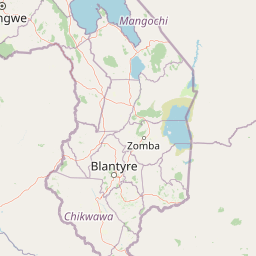
Map view of Lake Chilwa

Use this park location map to pinpoint Lake Chilwa in Malawi, understand its exact geographic position, and read its mapped placement within the surrounding landscape more clearly.

Pigeon | © OpenStreetMap contributors

Location context for Lake Chilwa

Zomba District

Explore high-resolution photography capturing shallow waters, flooded grasslands, and island terrain.

Lake Chilwa Photos and Landscape Scenery: Visualizing the Protected Wetland Environment

Visual records illustrate the shifting shorelines, expansive wetlands, and seasonal water fluctuations that define the protected basin. Examining these photographs reveals the unique environmental character of the wildlife habitats and surrounding terrain.

A wide view of the grassy shore of Lake Chilwa with small wooden fishing boats moored in shallow water, and a large hill, likely Chisi Island, rising in the background under a cloudy sky.

Park atlas

Compare adjacent wetland ecosystems and regional conservation landscapes

Parks Near Lake Chilwa and Surrounding Regional Protected Areas

Browsing parks near Lake Chilwa reveals connected wetland ecosystems and regional protected landscapes across the surrounding terrain. Expanding the geographic scope allows travelers to compare diverse wildlife habitats and regional topography beyond a single basin.
Nature reserveMalawi
About 41 km away#1 closest

West

Zomba Plateau Nature Reserve: Geographic Overview and Mapped Mountain Terrain

Protected montane landscapes in southern Malawi

Zomba Plateau stands as a significant granitic intrusion within the Shire Highlands, featuring high-altitude terrain and diverse forested patches. This record provides essential geographic context on its geological structure, forest reserves, and surrounding vistas across the southern Malawi landscape.

Area
130 km²
Established
1913
Relief
Mountain
Climate
Tropical
National parkSouthern Region
About 65 km away#2 closest

Northwest

Liwonde National Park: National Park in Malawi's Southern Region

Mapped Protected Area Boundaries and Geographic Context

Liwonde National Park is a designated national park situated in Malawi's Southern Region. This entry provides detailed geographic information, focusing on the park's mapped boundaries and its role within the broader atlas of protected landscapes. Explore the unique regional geography and conservation context that defines this protected area.

Area
548 km²
Established
1973
Relief
Upland
Climate
Tropical
Digital illustration of a large mountain range with jagged peaks, rolling green foothills, a central valley, and a stylized sun in a soft pastel sky.
Nature reserveMalawi
About 70 km away#3 closest

South

Mulanje Mountain Forest Reserve: Protected Afromontane Landscapes in Southern Malawi

Geographic overview of the Mulanje Massif and its high-elevation plateau

This nature reserve covers an isolated mountain block in Malawi, rising sharply to 3,002 meters at Sapitwa Peak. The landscape features rugged granite cliffs, deeply carved valleys, and extensive Afromontane forests that provide sanctuary for numerous endemic species. Use this atlas resource to understand the massif's vertical relief, plateau characteristics, and its central role in the regional geography of southeastern Africa.

Area
563.17 km²
Established
1927
Relief
Mountain
Climate
Tropical
Nature reserveChiradzulu District
About 70 km away#4 closest

Southwest

Chiradzulu Mountain Forest Reserve: Geography and Protected Area Profile

A rugged mountain landmark in the Shire Highlands of southern Malawi

Located in the heart of Chiradzulu District, this nature reserve protects a prominent mountain massif known for its unique silhouette and ecological importance. The site provides a vital reference point for understanding the mountainous terrain, regional reforestation progress, and the broader natural landscapes of the Shire Highlands.

Area
7.74 km²
Established
1924
Relief
Mountain
Scope
Terrestrial
Wildlife reserveMalawi
About 125 km away#5 closest

Southwest

Majete Wildlife Reserve: Geographic Atlas and Protected Area Map of Southern Malawi

Savanna landscapes and Shire River valley ecology

Majete Wildlife Reserve represents a premier example of habitat restoration in the Shire River valley. Spanning 700 square kilometers of varied terrain, the reserve protects a mosaic of riparian forest and savanna that has been carefully managed to sustain Big Five wildlife. Gain insight into the regional geography, protected landscape boundaries, and conservation history of this essential Malawian wildlife sanctuary.

Area
700 km²
Established
1955
IUCN
IV
Visitors
7K annual
National parkMalawi
About 130 km away#6 closest

Northwest

Lake Malawi National Park: UNESCO Protected Landscape and Endemic Fish Habitat

Discover mapped terrain, island geography, and evolutionary wonders.

Lake Malawi National Park offers unparalleled insight into freshwater biodiversity and landscape dynamics within Malawi's Great Rift Valley. As a UNESCO World Heritage Site, it is celebrated for its spectacular evolutionary radiation of cichlid fish, a phenomenon studied globally. The park's protected territory includes the mountainous Nankumbu Peninsula and thirteen islands, providing a rich context for understanding the interplay between aquatic ecosystems, terrestrial terrain, and unique island geography.

Area
94 km²
Established
1980
IUCN
II
Relief
Mountain
National parkMalawi
About 147 km away#7 closest

Southwest

Lengwe National Park: Malawi's Protected Landscape Atlas and Geographic Context

Mapped natural terrain and protected area boundaries in Malawi.

Lengwe National Park offers a focused look into Malawi's protected natural areas. As a designated national park, its geographic significance is highlighted through mapped boundaries and an understanding of the surrounding regional terrain. This entry provides essential context for exploring its identity as a protected landscape within southeastern Africa, contributing to a broader atlas of conservation areas.

Area
887 km²
Established
1970
IUCN
II
Climate
Tropical
Wildlife reserveNsanje District
About 169 km away#8 closest

Southwest

Mwabvi Wildlife Reserve: Mapping the Protected Landscapes of the Nsanje District

Geography, woodland terrain, and regional biodiversity.

Located in the southernmost Nsanje District of Malawi, Mwabvi Wildlife Reserve encompasses a unique convergence of dry Brachystegia woodland, sandstone hills, and open savanna grasslands. This protected area offers a deep look into the varied topographies of the Lower Shire region, providing a comprehensive understanding of the reserve's historic ecological importance and its current role in regional conservation.

Area
135 km²
Established
1953
IUCN
IV
Relief
Upland

Common questions about visiting, size, designation, and location context for Lake Chilwa

Lake Chilwa FAQs for park facts, access, geography, and protected area context

Find quick answers about Lake Chilwa, including protected-area facts, park geography, trail and visitor context, and how the park fits into its surrounding country and regional landscape.
MoriAtlas Explorer

Continue Your Protected Areas Search Across the Global Atlas

Deepen your exploration by continuing the structured search for national parks and protected areas worldwide. Utilize the comprehensive filtering capabilities to compare different conservation landscapes and refine your understanding of global park geography. Discover more about the distribution and characteristics of protected natural areas.

Global natural geography