
Beaches
Park geography
A detailed assessment of coastal terrain, island formations, and protected area extents
Geographic Profile of Lincoln National Park in South Australia: Maps and Boundary Analysis
This geographic profile details the physical characteristics of Lincoln National Park, covering its 216.38 square kilometer area and coastal landscape. The data includes spatial dimensions, surrounding island features, and significant terrain markers across this protected expanse in South Australia.
Related tags
Coastal national parksIsland ecosystemsMallee woodlandsLimestone cliffsSand dunes
Coastal peninsula wilderness on South Australia's Eyre Peninsula with dramatic limestone cliffs and island ecosystems
Lincoln National Park
Lincoln National Park is a protected coastal wilderness area located on the Jussieu Peninsula at the southeastern tip of Eyre Peninsula in South Australia, approximately 249 kilometres west of Adelaide and 9.5 kilometres south of Port Lincoln. The park encompasses a mainland area on the peninsula itself along with numerous adjacent islands scattered across the waters of Port Lincoln, Spencer Gulf, and the Great Australian Bight. Established as a Flora and Fauna Reserve in 1941 and proclaimed as a National Park in 1967, the area protects a distinctive blend of coastal mallee ecosystems, dramatic limestone cliffs, extensive sand dunes, and granite outcrop environments. The park holds significant heritage value encompassing indigenous Barngarla and Nauo cultural sites, early European exploration history dating to Matthew Flinders' 1802 visit, and remnants of 19th-century settlement including the operational Cape Donington Lighthouse.
- Location
- Australia
- Park type
- National park
- Established
- 1941
- Area
- 216.4 km²
Location overview
Analyzing regional placement and protected maritime zones in Australia
Lincoln National Park Coastal and Island Geography in South Australia
Lincoln National Park is situated within the state of South Australia in Australia. Protected status records identify the reserve as a coastal, island, and marine territory managed under a single national jurisdiction.
- Countries
- Australia
- Regions
- South Australia
- Primary location
- South Australia
- Geographic setting
- Coastal · Island · Marine
Boundary and coordinates
Interactive boundary geometry and derived spatial measurements
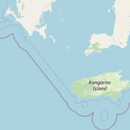
Lincoln National Park Boundary Map and Spatial Extent
Interactive mapped outlines establish complete spatial context for regional geographic exploration. Accompanying factual panels detail calculated area measurements and coordinate spans without survey claims.
- Boundary area
- 214.4 km²
- Boundary perimeter
- 160.4 km
- Northernmost point
- 34.6036° S
- Southernmost point
- 35.07° S
- Easternmost point
- 136.1831° E
- Westernmost point
- 135.6161° E
- Geographic centre
- 34.8394° S, 135.8879° E
- North–south span
- 51.7 km
- East–west span
- 51.9 km
Terrain and natural features
Upland terrain classifications and recorded coastal and island features
Lincoln National Park Terrain and Mapped Natural Features
Upland terrain classifications define the protected landscape alongside recorded beaches, islands, and capes. Linked feature cards supply names, types, measurements, and spatial relationships.
Selected named natural features
Beaches
Donington Beach
Islands
Bicker Isles
Capes
Surfleet Point
Viewpoints
Wanna Lookout
Beaches
Tinah Beach
Environmental setting
Analysis of recorded upland relief, forest cover, and coastal features
Lincoln National Park Environmental Settings and Mapped Geography
Stored classifications combine upland relief, major water presence, and forest cover to frame the physical setting. Recorded landscape categories connect directly to related regional records across the protected area network.
- Relief
- Upland
- Water
- Major water bodies
- Forest cover
- Mostly forested
Landscape features
Cliffs · Dunes · Coast · Islands · Forest · Beach
Habitat types
Shrubland · Dune habitat · Coastal habitat · Marine habitat
Park atlas
Trace the regional geography of protected areas, comparing coastal wilderness and island ecosystems throughout the Eyre Peninsula.
Discover Other National Parks and Coastal Protected Areas Near Lincoln National Park, Eyre Peninsula
Browse other national parks and protected areas near Lincoln National Park, encompassing coastal wilderness, diverse mallee woodlands, and significant island ecosystems on the Eyre Peninsula. Compare their unique geographic features, trace patterns of conservation landscapes in South Australia, and discover adjacent natural environments beyond one specific park's boundaries.
Wildlife reserveSouth Australia
5.7 km away#1 closest
North

Kathai Conservation Park: Protected Wildlife Reserve on the Eyre Peninsula
Mapping the Uley catchment basin and mallee forest terrain
Kathai Conservation Park serves as a crucial protected landscape in South Australia, anchored by the prominent Northside Hill. The reserve maintains critical habitat for coastal white mallee and rare vegetation within the wider Uley catchment basin, showcasing how small protected areas sustain regional ecological diversity.
- Area
- 0.81 km²
- Established
- 1985
- IUCN
- III
- Relief
- Upland
National parkSouth Australia
22 km away#2 closest
Northwest
Coffin Bay National Park: Protected Landscape and Geographic Context in South Australia
Explore the mapped boundaries and regional geography of this national park.
Coffin Bay National Park presents a distinct protected landscape within South Australia, offering a valuable point of entry for geographic discovery. This page details the park's national park designation and its mapped territory, crucial for understanding its role in Australia's atlas of natural areas. Delve into the park's specific geographic context and the outlines of its protected lands, providing a clear picture of its landscape within the state's broader terrain.
- Area
- 309.76 km²
- Established
- 1982
- IUCN
- II
- Relief
- Lowland
National parkAustralia
About 67 km away#3 closest
Southeast
Dhilba Guuranda-Innes National Park: A Detailed Look at Its Australian Protected Landscape
Explore the park's mapped geography and natural terrain.
This section offers a focused atlas exploration of Dhilba Guuranda-Innes National Park, detailing its significance as a protected natural area within Australia. Gain understanding of its unique geographic characteristics, mapped boundaries, and its contribution to the country's diverse natural landscapes. This provides detailed context for anyone interested in Australia's protected land inventory and regional geography.
- Area
- 94.15 km²
- Established
- 1970
- Visitors
- 200K annual
- Relief
- Mixed relief
National parkAustralia
About 67 km away#4 closest
Southeast
Innes National Park National Park: Mapped Protected Landscape and Regional Geography
Explore its geographic setting and natural terrain.
Delve into the protected landscape and geographic particulars of Innes National Park. This entry provides detailed insights into its mapped boundaries and the surrounding natural terrain within Australia. Understanding Innes National Park's place in the broader geographic atlas helps users compare and contrast protected areas across different regions and nations.
- IUCN
- II
Marine protected areaSouth Australia
About 78 km away#5 closest
South
Western Kangaroo Island Marine Park: Geographic Profile and Protected Marine Environment
South Australian marine geography and protected seafloor zones.
Western Kangaroo Island Marine Park guards a vital swath of the continental shelf and upper slope in South Australia. The protected area features a unique submerged ancient coastline and deep nutrient-rich waters that support diverse marine ecological processes within the Spencer Gulf Shelf Province.
- Area
- 2,335.31 km²
- Established
- 2012
- IUCN
- II
- Relief
- Lowland
Protected areaSouth Australia
About 80 km away#6 closest
East
Carribie Conservation Park: Mapped Geography and Protected Area Overview in South Australia
Ecological terrain and native vegetation remnants on the Yorke Peninsula
Carribie Conservation Park is a 19-hectare protected area situated on the southern Yorke Peninsula of South Australia. The terrain consists of an undulating sandy plain characterized by two contrasting vegetation zones: a northern mallee scrub and a southern sheoak and tea-tree woodland. As a formal conservation site, it provides a vital window into the original botanical character of the region.
- Area
- 0.19 km²
- Established
- 1968
- IUCN
- III
- Relief
- Lowland
Wildlife reserveSouth Australia
81 km away#7 closest
North
Hincks Conservation Park: Protected Wildlife Reserve in South Australia
Mapping regional biodiversity and conservation landscapes
Hincks Conservation Park functions as a key protected area within the semi-arid coastal hinterland of the Eyre Peninsula. This reserve preserves an essential fragment of native vegetation against a surrounding backdrop of agricultural development. The site highlights the importance of managed land corridors in maintaining ecological connectivity across the central-eastern reaches of South Australia.
- Area
- 8.78 km²
- Established
- 1941
- IUCN
- VI
- Relief
- Lowland
Nature reserveSouth Australia
82 km away#8 closest
West
Greenly Island Conservation Park: Geography and Protected Nature Reserve Map
Island protected area off the South Australian Eyre Peninsula.
This offshore nature reserve preserves an exposed, rocky island environment in the Southern Ocean. As a protected area for marine mammal haul-out sites, it provides a unique look at isolated coastal terrain and strict conservation management along the western shoreline of South Australia.
- Area
- 1.68 km²
- Established
- 1967
- IUCN
- Ia
- Relief
- Lowland
MoriAtlas Explorer
Continue Exploring Lincoln National Park's Geography and Protected Landscape Boundaries
Deepen your understanding of Lincoln National Park by exploring its specific geographic features and protected area mapping. This focused view within South Australia offers valuable context for regional landscape analysis and atlas-driven discovery of protected lands. Understand the intricate relationship between the park's terrain and its surrounding geography for a richer understanding.
Browse next
Global natural geography
Explore related park routes
Explore MoriAtlas Global ParksBrowse All MoriAtlas ParksGlobal Park Map DiscoveryMoriAtlas: Browse All CountriesBrowse All MoriAtlas ContinentsNational Park Environment AtlasGrand Canyon National Park AtlasYellowstone National Park AtlasYosemite National Park Atlas and GeographySerengeti National Park AtlasGalápagos National Park Protected LandscapeBanff National Park Geography and AtlasKruger National Park Atlas EntryUluṟu-Kata Tjuṯa National Park AtlasExplore Uluru-Kata Tjuta National Park GeographyPlitvice Lakes National Park AtlasFiordland National Park Protected LandscapeGreat Smoky Mountains National Park AtlasAfghanistan National Parks and Protected AreasAlbania National Parks and Protected AreasAlgeria National Parks and Protected AreasAmerican Samoa National Parks and Protected AreasAndorra National Parks and Protected AreasAngola National Parks and Protected AreasAntarctica National Parks and Protected AreasAntigua and Barbuda Park List