

Mori Atlas logo
Nature reserveLucas Heights Conservation Area

Tracing the Ecological Transition Between Hawkesbury Sandstone and Shale Landscapes

Lucas Heights Conservation Area: An Essential Protected Nature Reserve in New South Wales

The Lucas Heights Conservation Area represents a significant protected bushland within the Sutherland Shire, spanning 111.7 hectares of complex terrain. This nature reserve serves as a critical junction where Hawkesbury Sandstone plateaus meet shale-influenced slopes. Such geological diversity supports threatened communities like Sydney Turpentine-Ironbark Forest and provides a home for rare plant species in the heart of New South Wales.

sandstone woodlandshale transition forestbushland reservesydney basincouncil-managed conservationthreatened ecological community

Lucas Heights Conservation Area

Nature reserve

Park overview

Structured park overview, official facts, and landscape profile for Lucas Heights Conservation Area

Lucas Heights Conservation Area park facts, protected area profile, and essential visitor context

Review the core facts for Lucas Heights Conservation Area, including designation, size, terrain, visitor scale, habitats, and operating context in one park-focused overview.

About Lucas Heights Conservation Area

The Lucas Heights Conservation Area is a council-managed bushland reserve in the Sutherland Shire of southern Sydney, recognised both for its ecological significance and for its recorded Aboriginal cultural heritage. Located between Lucas Heights and Menai, near Heathcote Road and the Holsworthy Barracks boundary, the reserve forms an important green buffer within an otherwise heavily modified suburban and industrial landscape.

The reserve sits within the Mill Creek catchment, with Mill Creek rising near the Lucas Heights Resource Recovery Park and flowing north through the conservation area before ultimately draining into the Georges River. This catchment context shapes both the reserve's hydrology and its ecological character, tying the conservation area into a wider network of waterways and bushland that links remnant vegetation across southern Sydney.

Ecologically, the area is distinctive because of its geological transition. Sandstone plateaus, rocky platforms and escarpments dominate much of the landscape, but shale-derived soils occur in parts of the reserve, particularly in the north-east and around the Little Forest area. This combination has produced five broad vegetation communities identified in the 2002 plan of management: Sydney Turpentine–Ironbark Forest, smooth-barked apple woodland, scribbly gum–red bloodwood woodland, mallee and heathland, and wet heath and sedgeland. The result is a complex mosaic of woodland, heath and forest types, with habitat values that support both common and threatened species.

Culturally, the reserve carries substantial Aboriginal heritage value. It lies within the area of the Gandangara Local Aboriginal Land Council and is recorded on the New South Wales Aboriginal Heritage Information Management System. Sites documented within and adjacent to the reserve include grinding grooves, artefact scatters, stone arrangements, rock art and shelters. The council's plan of management commits to consulting with the Gandangara community on cultural surveys and the placement of visitor infrastructure.

Today, the Lucas Heights Conservation Area functions as a multi-purpose conservation landscape: a refuge for threatened ecological communities, a site of ongoing bush regeneration and weed control, a quiet area for low-impact bushwalking and environmental education, and a place of recognised Aboriginal cultural significance within greater Sydney.

Quick facts and research context for Lucas Heights Conservation Area

The Lucas Heights Conservation Area lies about 30 kilometres south-west of the Sydney central business district, on the south-western edge of the Sutherland Shire. It occupies roughly 111.7 hectares of the Mill Creek catchment, through which Mill Creek flows north toward the Georges River.

The reserve was transferred to Sutherland Shire Council in 2002 for conservation purposes and is now managed as community land categorised as a natural area. Within the wider Little Forest conservation landscape, the 6.9-hectare Gandangara State Conservation Area was formally reserved in 2011 under the care of the NSW National Parks and Wildlife Service.

Protection and recognition

Review documented terrestrial protection scope and administrative recognition data.

Lucas Heights Conservation Area Protection Status and Formal Designation Facts

Lucas Heights Conservation Area maintains a defined terrestrial protection scope within its regional landscape. Comprehensive protected area designation records outline the established management framework and formal conservation status.

Protection details

Protection scope
Terrestrial
Transboundary protection
No
Park context

Deeper park guide and search-rich context for Lucas Heights Conservation Area

Lucas Heights Conservation Area history, landscape, wildlife, and travel context

Explore Lucas Heights Conservation Area through its history, landscape character, ecosystems, wildlife, conservation priorities, cultural context, and seasonal travel timing in a structured park guide built for atlas discovery and search intent.

Why Lucas Heights Conservation Area stands out

The reserve is best known for sitting at the ecological transition between Hawkesbury Sandstone and shale landscapes, producing a complex mosaic of vegetation communities in a relatively small area near Sydney. It protects significant stands of Sydney Turpentine, Ironbark Forest and Shale Sandstone Transition Forest, both threatened ecological communities, and supports rare plant populations including Allocasuarina diminuta subsp. mimica and Melaleuca deanei. Equally important is its Aboriginal cultural heritage value. Numerous recorded sites of grinding grooves, artefact scatters, rock art and shelters occur within and around the conservation area, placing it among the meaningful cultural landscapes of the Sutherland Shire and the broader Gandangara country.
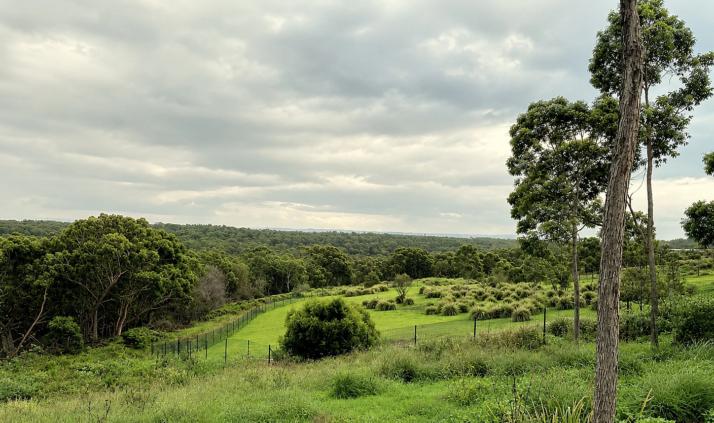
An elevated landscape view of a green, grassy meadow framed by scattered bushes and native trees under a cloudy sky.
A view across the bushland terrain of the Lucas Heights Conservation Area.

Lucas Heights Conservation Area history and protected-area timeline

The conservation area originated as land held by Waste Service NSW. It had originally been earmarked as a northern extension of the Lucas Heights waste management facility, but during the 1990s its future was reconsidered through environmental mediation involving Sutherland Shire Council and Waste Service NSW. A 1996 report by the Office of Environmental Mediation and Inquiry clarified management responsibilities for several Lucas Heights parcels, and in April 2002 approximately 111.7 hectares were transferred to Sutherland Shire Council for conservation purposes.

That same year, on 20 May 2002, the council adopted the Plan of Management for Natural Areas – Lucas Heights Conservation Area. The plan built on an earlier environmental management plan prepared by National Environmental Consulting Services, with objectives that included reversing environmental degradation, rehabilitating disturbed land and shifting the area away from uncontrolled four-wheel-drive and trail-bike use toward conservation and low-impact public access.

An archaeological survey in 1997 identified multiple sites of Aboriginal significance across the area, laying the groundwork for ongoing cultural heritage consultation. A smaller parcel of stringybark–ironbark open forest was earmarked for transfer to the National Parks and Wildlife Service, and in 2011 this became the Gandangara State Conservation Area, a roughly 6.9-hectare reserve under NSW state management. Conservation works since have focused on weed control, bush regeneration, vehicle-track rehabilitation, fencing and revegetation, including a 2025 project planting 2,000 koala habitat trees in a former clay quarry area known as "the Paddock".

Lucas Heights Conservation Area landscape and geographic character

The conservation area occupies part of the Sydney Basin bioregion, with terrain shaped by the underlying Hawkesbury Sandstone and the influence of shale-derived soils. The result is a landscape of sandstone plateaus, slopes and drainage lines, broken by rocky platforms and escarpments. Mill Creek and its smaller tributaries cut through the reserve, linking the steep upper country to lower ground that drains ultimately into the Georges River.

Topography, geology, aspect and soil depth interact across the site, generating sharp local variation. Sandstone ridges give way to sheltered shale slopes and small alluvial flats, producing a mosaic of woodland, heath and wetter communities within a relatively compact footprint. The Little Forest area near the headwaters of Mill Creek is a notable example of this transition, with vegetation and soils reflecting the meeting of shale and sandstone substrates.

The reserve's setting is also shaped by its surrounding land uses. It lies north of the Lucas Heights Resource Recovery Park, near Heathcote Road and Holsworthy Barracks, providing a substantial block of bushland in a landscape otherwise defined by suburban development, defence land and waste-management infrastructure.

Lucas Heights Conservation Area ecosystems, habitats, and plant life

The reserve's ecological identity is defined by vegetation communities adapted to shallow, nutrient-poor sandstone soils, with the addition of shale-influenced communities where shale substrates occur. Five broad communities identified in the 2002 plan of management underpin this identity: Sydney Turpentine–Ironbark Forest, smooth-barked apple woodland, scribbly gum–red bloodwood woodland, mallee and heathland, and wet heath and sedgeland.

Among these, Sydney Turpentine–Ironbark Forest is a state- and Commonwealth-listed threatened ecological community that occupies shale soils in the north-eastern part of the reserve. The Little Forest area supports Shale Sandstone Transition Forest, another threatened community, and is considered an important remnant of shale-associated forest within the region. The broader reserve also hosts rare plant populations, with Allocasuarina diminuta subsp. mimica, a dwarf she-oak, described in catchment planning as having its main Australian stronghold in the Mill Creek catchment, and the threatened shrub Melaleuca deanei recorded within the conservation area.

Wet heath, sedgeland and mallee communities add further ecological variety, occupying harsher sandstone sites and providing habitat structure that complements the taller woodlands. Together these communities form a transition landscape where sandstone and shale ecological worlds meet.

Lucas Heights Conservation Area wildlife and species highlights

Wildlife in the Lucas Heights Conservation Area reflects its mix of sandstone woodland and heath habitats, alongside the shale-influenced forests of the Little Forest area. Threatened species recorded around the time of the 2002 plan of management included the red-crowned toadlet, the powerful owl and the greater sooty owl. Five threatened animal species were considered capable of occurring within the Gandangara State Conservation Area: the red-crowned toadlet, Rosenberg's monitor, the powerful owl, the koala and the grey-headed flying fox.

Birdlife is a particular feature of the conservation area, especially within the Gandangara State Conservation Area,(...) the dusky woodswallow, the weebill and the double-barred finch are among the woodland birds recorded. Introduced animals such as red foxes, feral cats and feral deer are documented in the wider landscape, presenting ongoing management concerns alongside weeds including crofton weed and exotic grasses.

Lucas Heights Conservation Area conservation status and protection priorities

The Lucas Heights Conservation Area is significant from a conservation perspective because it protects a rare local example of the ecological transition between Hawkesbury Sandstone and shale landscapes within an urbanised part of Sydney. It shelters threatened ecological communities, including Sydney Turpentine–Ironbark Forest and Shale Sandstone Transition Forest, and supports populations of rare plants such as Allocasuarina diminuta subsp. mimica and Melaleuca deanei.

Prior to formal protection, the site suffered from unauthorised four-wheel-drive and trail-bike use, vegetation clearing, rubbish dumping and erosion, with informal vehicle tracks damaging both habitat and water quality in Mill Creek. Conservation efforts since 2002 have focused on rehabilitation of disturbed land, weed control, bush regeneration, closure and revegetation of vehicle tracks, fencing and erosion mitigation. The rehabilitation of the former clay quarry site known as Bourke's Quarry, and recent plantings of 2,000 koala habitat trees in "the Paddock" in 2025, reflect an active program of landscape recovery.

The inclusion of the Gandangara State Conservation Area under NSW National Parks and Wildlife Service management adds a higher level of statutory protection to part of this landscape and helps anchor ongoing management of fire risk, weeds, pest animals and illegal off-road vehicle use across the broader reserve.

Lucas Heights Conservation Area cultural meaning and human context

The Lucas Heights Conservation Area lies within the cultural landscape of the Gandangara people and falls within the area of the Gandangara Local Aboriginal Land Council. An archaeological survey completed in 1997 identified several sites of Aboriginal significance across the reserve, and the area is recorded on the New South Wales Aboriginal Heritage Information Management System.

Documented cultural features include grinding grooves, artefact scatters, stone arrangements, rock art and rock shelters, with sites found both within the wider conservation area and in surrounding bushland. Although no Aboriginal sites had been formally recorded within the small Gandangara State Conservation Area itself as of 2014, the surrounding landscape carries substantial cultural value.

The council's plan of management recognises this heritage by committing to ongoing cultural surveys in consultation with the Gandangara Local Aboriginal Land Council, and by requiring visitor infrastructure such as walking tracks to take Aboriginal cultural heritage into account.

Top sights and standout views in Lucas Heights Conservation Area

Ecological transition between Hawkesbury Sandstone and shale landscapes, supporting five distinct vegetation communities in a small area.

Significant populations of threatened ecological communities including Sydney Turpentine–Ironbark Forest and Shale Sandstone Transition Forest.

Rare plant records including Allocasuarina diminuta subsp. mimica, a dwarf she-oak with its main Australian stronghold in the Mill Creek catchment, and the threatened shrub Melaeuca deanei.

A documented network of Aboriginal heritage sites, including grinding grooves, artefact scatters, rock art and shelters, within Gandangara country.

An active rehabilitation story, from an unauthorised four-wheel-drive and trail-bike site to a council-managed conservation reserve with revegetation and koala habitat tree plantings.

Best time to visit Lucas Heights Conservation Area

As a Sydney-based bushland reserve, the Lucas Heights Conservation Area can be visited throughout the year, with cooler and drier months typically offering the most comfortable conditions for bushwalking and birdwatching. Spring is often rewarding for wildflower and heath display in sandstone communities, while autumn and winter tend to make creek-side walking more pleasant and reduce the activity of snakes and other reptiles.

The reserve's sandstone woodland and heath habitats support different wildlife viewing opportunities across the year, with bird activity generally pronounced in the cooler months and reptiles more readily encountered in warmer weather. Visitors interested in viewing the broader landscape character rather than a single seasonal peak will generally find that the transitional shrub and woodland mosaic gives the area a persistent bushland appeal across seasons, though specific access conditions and track availability should be confirmed with the managing council.

Monthly climate preview

Long-term monthly temperature and precipitation averages for Lucas Heights Conservation Area

Lucas Heights Conservation Area Climate Normals and Annual Temperature Rhythm

Historical climate data for Lucas Heights Conservation Area documents measured monthly temperature ranges alongside consistent baseline precipitation patterns. Detailed twelve-month climatology records provide deeper insight into regional thermal variation and multi-year environmental rhythms.
Annual mean18 °C
14 °C23 °C
Jan23°
Feb23°
Mar22°
Apr20°
May17°
Jun15°
Jul14°
Aug14°
Sep16°
Oct18°
Nov20°
Dec21°
Warmest month
January

22.7 °C

Coolest month
July

13.8 °C

Wettest month
February

4.4 mm/day

Driest month
July

1.6 mm/day

Park location guide

Geography guide, regional context, and park location map for Lucas Heights Conservation Area

Lucas Heights Conservation Area park geography, regions, and map view in Australia

Understand where Lucas Heights Conservation Area sits in Australia through a broader geographic reading of the surrounding landscape, nearby location context, and its mapped position within the national park landscape.

How Lucas Heights Conservation Area fits into Australia

Australia is a constitutional monarchy and federal parliamentary democracy comprising six states and ten territories. With a population of nearly 28 million, it is one of the world's most urbanised countries, with most people concentrated on the eastern seaboard. The country has a high Human Development Index and is known for its cultural diversity, ancient Aboriginal heritage, and unique wildlife.

Wider geography shaping Lucas Heights Conservation Area in Australia

Australia occupies the entire Australian continent, the island of Tasmania, and numerous smaller islands. It is the world's flattest and driest inhabited continent, featuring vast deserts in the interior (the Outback), tropical rainforests along the eastern coast, and a coastline bordering the Indian and Pacific Oceans.

Map view of Lucas Heights Conservation Area

Use this park location map to pinpoint Lucas Heights Conservation Area in Australia, understand its exact geographic position, and read its mapped placement within the surrounding landscape more clearly.

Pigeon | © OpenStreetMap contributors

Location context for Lucas Heights Conservation Area

New South Wales

Visualizing sandstone plateaus, shale transition forests, and protected bushland habitats

Lucas Heights Conservation Area Photos and Landscape Scenery

Visual documentation of Lucas Heights Conservation Area reveals the complex terrain of sandstone plateaus, rocky platforms, and sheltered drainage lines shaping the Sydney Basin. Examining these protected habitats provides clear insight into the ecological transition zones and native bushland character preserved across the reserve.

An elevated landscape view of a green, grassy meadow framed by scattered bushes and native trees under a cloudy sky.

Park atlas

Compare adjacent sandstone reserves, bushland corridors, and regional natural areas.

Other Parks Near Lucas Heights Conservation Area And Regional Protected Landscapes

Browsing nearby protected areas allows researchers and visitors to compare the sandstone plateaus and shale transition forests surrounding Lucas Heights Conservation Area. Evaluating adjacent reserves provides broader geographic context across the Sydney Basin bioregion and regional conservation corridors.
National parkNew South Wales
About 3.5 km away#1 closest

South

Heathcote National Park: Discover the Hawkesbury Sandstone Terrain and Mapped Protected Boundaries

Explore the rugged gorges and regional geography of this New South Wales national park.

Heathcote National Park preserves a significant example of the Sydney region's characteristic Hawkesbury sandstone landscape, presenting a terrain of deeply incised creek gorges and rocky valleys. Located in New South Wales, this protected national park offers valuable insights into regional geography and the mapped distribution of natural landscapes. Its rugged terrain and diverse ecosystems make it a key destination for understanding the protected area context of Australia's eastern seaboard.

Area
26.79 km²
Established
1943
IUCN
II
Relief
Mixed relief
National parkNew South Wales
About 5 km away#2 closest

Northeast

Georges River National Park: Protected Landscape and Geographic Context in New South Wales

Mapped terrain, sandstone woodlands, and key wetland habitats.

Georges River National Park, located within New South Wales, Australia, serves as a crucial protected natural area. Its 514 hectares encompass diverse terrain shaped by the Georges River, featuring significant mangrove swamps, salt marshes, and exposed sandstone woodlands characteristic of the Sydney region. This park's atlas value lies in its role preserving vital ecosystems, supporting a notable array of vertebrate and bird species, and showcasing unique natural landscapes easily explored through mapped terrain and geographic context.

Area
5.14 km²
Established
1992
IUCN
II
Relief
Lowland
National parkNew South Wales
About 5.1 km away#3 closest

Southeast

Royal National Park National Park: Geographic Atlas and Protected Landscape Context

Explore mapped park boundaries and regional terrain.

Royal National Park is a designated national park in New South Wales, Australia, offering rich opportunities for geographic discovery and landscape context analysis. This page serves as a foundational entry for understanding the park's protected status, its distinct natural terrain, and its mapped presence within the regional geography. Explore how this protected landscape contributes to Australia's broader atlas of natural areas.

Area
150.91 km²
Established
1879
IUCN
II
Relief
Mixed relief
National parkNew South Wales
About 12 km away#4 closest

West

Georges River Koala National Park: A Protected Landscape for Critical Koala Habitat in New South Wales

Mapped geography and unique wildlife sanctuary.

Georges River Koala National Park represents a key protected area within New South Wales, specifically designated for safeguarding critical koala populations. This national park offers an invaluable insight into the region's undulating woodland terrain and the Georges River corridor's role in providing essential habitat. Understand the park's landscape character, its mapped boundaries, and its importance as a sanctuary for chlamydia-free koala colonies.

Area
18.3 km²
Established
2023
IUCN
II
Relief
Lowland
A watercolor painting showing a soft, pastoral landscape with green trees, grassy plains, and rolling hills in the background on a white background.
State or regional parkNew South Wales
About 12 km away#5 closest

South

Garawarra State Conservation Area: Protected Geography and Natural Landscapes in New South Wales

Ecological reserve features, mapped sandstone terrain, and temperate rainforest mosaics.

Garawarra State Conservation Area occupies a strategic position on the southern edge of the Sydney Basin, functioning as an important ecological buffer within a highly urbanised region. The park landscape is defined by its dramatic transition from dry sandstone heath and tall wet sclerophyll forests to humid, sheltered creek lines dominated by diverse rainforest flora. This protected area stands as a testament to the resilience of Sydney Sandstone ecosystems, offering a rich study in biodiversity within reach of the metropolitan sprawl.

Area
9.49 km²
Established
1987
Relief
Upland
Climate
Temperate
Wildlife reserveNew South Wales
About 15 km away#6 closest

North

Chipping Norton Islands Wildlife Reserve: Mapped Landscapes and Geographic Overview

A vital wetland refuge in the Georges River floodplain

The Chipping Norton Islands comprise four distinct islets within a reclaimed lake landscape, serving as a sanctuary for over fifty bird species. This protected reserve illustrates the intersection of human-modified terrain and native ecosystems, featuring fringing mangroves, reed beds, and remnants of alluvial woodland that define this unique western Sydney habitat.

Relief
Lowland
Climate
Temperate
Access
Highly restricted
Scope
Terrestrial
National parkNew South Wales
About 17 km away#7 closest

Southwest

Dharawal National Park: Sandstone Landscapes and Upland Swamp Ecosystem Atlas

Discover mapped protected area boundaries and unique biodiversity.

Dharawal National Park, situated in New South Wales, is a significant protected area distinguished by its globally important upland swamp ecosystems, which exhibit the highest species richness of shrub and sedge communities found anywhere on Earth. This national park features a varied terrain, from steep gorges and waterfalls to sandstone woodlands and rainforest valleys, all contributing to its exceptional biodiversity and status as a crucial koala habitat within southern Sydney. Its landscape context on the Woronora Plateau provides a unique geographic perspective for understanding protected Australian natural areas.

Area
65.08 km²
Established
2012
IUCN
II
Relief
Mixed relief
State or regional parkNew South Wales
About 20 km away#8 closest

South

Illawarra Escarpment State Conservation Area: Mapped Geography and Protected Area Context

Regional protected landscape and sandstone escarpment in New South Wales

Examine the geographic structure and landscape composition of the Illawarra Escarpment State Conservation Area. This resource maps the 40-kilometre stretch of sandstone cliffs and forested foothills that rise above the Illawarra coastal plain, providing a detailed look at the six sections that constitute this unique state conservation land.

Area
27.72 km²
Established
1980
Relief
Mountain
Climate
Temperate

Common questions about visiting, size, designation, and location context for Lucas Heights Conservation Area

Lucas Heights Conservation Area FAQs for park facts, access, geography, and protected area context

Find quick answers about Lucas Heights Conservation Area, including protected-area facts, park geography, trail and visitor context, and how the park fits into its surrounding country and regional landscape.
MoriAtlas Explorer

Continue Your Protected Areas Search Across the Global Atlas

Deepen your exploration by continuing the structured search for national parks and protected areas worldwide. Utilize the comprehensive filtering capabilities to compare different conservation landscapes and refine your understanding of global park geography. Discover more about the distribution and characteristics of protected natural areas.

Global natural geography