

Mori Atlas logo
National parkLucayan National Park

Discover the mapped boundaries and regional geography of this important national park.

Lucayan National Park: Grand Bahama's Protected Landscape Atlas and Geographic Context

Lucayan National Park on Grand Bahama represents a significant protected landscape within the Bahamas, offering a unique window into regional geography and natural terrain. This atlas-focused entry provides a detailed view of the park's mapped boundaries, contributing to a broader understanding of protected areas and their placement within the wider geographic context of the region. Explore the structured information that defines Lucayan National Park's identity as a key natural landmark.

underwater cavesmarine protected areaCaribbean islandsImportant Bird Areacave divingtroglobitic species

Lucayan National Park

National park

Park overview

Structured park overview, official facts, and landscape profile for Lucayan National Park

Lucayan National Park park facts, protected area profile, and essential visitor context
Review the core facts for Lucayan National Park, including designation, size, terrain, visitor scale, habitats, and operating context in one park-focused overview.

About Lucayan National Park

Lucayan National Park occupies a distinctive position among Caribbean protected areas as a coastal park that protects both terrestrial and submerged environments. Located on the eastern shoreline of Grand Bahama Island, the park encompasses a landscape characterized by coastal vegetation, beach zones, and the extraordinary underwater cave system that lies beneath the island's surface. The cave system consists of vertical shafts and horizontal passages filled with stratified water layers of differing salinity, creating unique physicochemical conditions that have supported the evolution of endemic species found nowhere else on Earth. The park's establishment in 1982 marked an important step in the Bahamas' commitment to environmental conservation, with management responsibilities delegated to the Bahamas National Trust, the nation's primary conservation authority. Visitors to the park can experience the cave system's entrance through guided recreational diving and snorkeling experiences that allow exploration of the upper passages, while scientific access to deeper sections has yielded numerous biological discoveries since the initial Remipedia find.

Quick facts and research context for Lucayan National Park

Lucayan National Park is situated on the eastern coast of Grand Bahama, near the town of Freeport. The park protects a combination of coastal environments including beach, mangrove, and subtidal cave systems. It was designated as an Important Bird Area by BirdLife International, providing crucial habitat for several endemic Caribbean bird species including the thick-billed vireo, Bahama swallow, and olive-capped warbler. The park's underwater cave system, known for its accessibility and length, supports unique troglobitic (cave-dwelling) species that have evolved in complete isolation. The total protected area spans roughly 1,937 acres combining both land and marine zones.

Park context

Deeper park guide and search-rich context for Lucayan National Park

Lucayan National Park history, landscape, wildlife, and travel context
Explore Lucayan National Park through its history, landscape character, ecosystems, wildlife, conservation priorities, cultural context, and seasonal travel timing in a structured park guide built for atlas discovery and search intent.

Why Lucayan National Park stands out

Lucayan National Park is best known for its remarkable underwater cave system, which extends for approximately 6.4 miles (10.3 kilometers) of charted passages beneath Grand Bahama. This submerged cave network is among the longest in the world and contains pristine freshwater pools that have been isolated from surface contact for thousands of years. The park gained scientific prominence in 1979 when researchers discovered the Remipedia class of crustaceans here, a group of blind, colorless cave-dwelling crustaceans previously unknown to science. This discovery positioned Lucayan National Park as a site of global scientific significance in the study of subterranean marine ecosystems and evolutionary biology.

Lucayan National Park history and protected-area timeline

Lucayan National Park was formally established in March 1982, representing one of the earlier protected area designations in the Bahamas' national park system. The park's creation was motivated by the need to preserve the significant underwater cave resource and the unique biological communities it supports. Prior to the park's establishment, the area gained international scientific attention in 1979 when a team of researchers discovered the Remipedia class of crustaceans within the cave system, a breakthrough that fundamentally expanded understanding of crustacean diversity and cave-adapted marine life. The discovery of these primitive, blind crustaceans in Lucayan's caves represented one of the most significant zoological finds of the late twentieth century and continues to draw researchers to the site. The park was subsequently recognized as an Important Bird Area, acknowledging its role in protecting habitat for Caribbean bird species, and has been managed by the Bahamas National Trust since its inception as part of the organization's broader conservation mandate.

Lucayan National Park landscape and geographic character

The physical landscape of Lucayan National Park encompasses a coastal environment with distinctive above-and-below-water characteristics. Above the surface, the park features typical Bahamian coastal terrain including sandy beach zones, coastal scrub vegetation, and mangrove areas that transition into the subtidal zone. The underwater component represents the park's most extraordinary landscape feature, comprising an extensive network of flooded caves formed through dissolution of the limestone bedrock that underlies Grand Bahama. These caves feature vertical shafts descending from the surface and extensive horizontal passage networks that extend inland from the coast. The cave passages contain standing water with pronounced haloclines where fresh groundwater meets denser saltwater, creating visually striking stratified water columns. The cave walls display typical speleothem formations including stalactites and flowstone, evidence that these passages were once dry caverns during past sea-level low stands.

Lucayan National Park ecosystems, habitats, and plant life

The ecological character of Lucayan National Park is defined by two distinct environments: the surface coastal ecosystem and the subterranean cave system. The surface areas support typical Bahamian coastal habitats including beach vegetation, scrubland, and mangrove communities that provide roosting and foraging habitat for multiple bird species. The park's designation as an Important Bird Area reflects its particular significance for three species: the thick-billed vireo, Bahama swallow, and olive-capped warbler, all of which nest and forage within the park's boundaries. Below the surface, the underwater cave system hosts an extraordinary array of specialized species that have evolved in complete darkness over millennia. The discovery of Remipedia crustaceans in 1979 revealed a previously unknown group of ancient crustaceans that represent some of the most primitive forms of modern crustaceans. These cave-adapted species have lost their eyes and pigmentation, adapting to a life of complete darkness in the stratified waters of Lucayan's submerged passages.

Lucayan National Park wildlife and species highlights

The wildlife of Lucayan National Park spans surface-dwelling Caribbean fauna and an extraordinary subterranean ecosystem. Among the most significant wildlife residents are the bird species that depend on the park's coastal and scrub habitats, particularly the thick-billed vireo, Bahama swallow, and olive-capped warbler, all of which are protected under the park's Important Bird Area status. However, the park's most notable wildlife resides beneath the water's surface. The underwater cave system contains the Remipedia, a class of crustaceans discovered in 1979 that represents a primitive group of cave-dwelling crustaceans previously unknown to science. These blind, colorless creatures navigate the dark waters of Lucayan's cave passages using specialized sensory adaptations. Additional troglobitic species continue to be discovered within the cave system, making it one of the most biologically significant submerged cave environments in the Caribbean region.

Lucayan National Park conservation status and protection priorities

Lucayan National Park holds significant conservation importance at both regional and global scales. The park's designation as an Important Bird Area by BirdLife International acknowledges its critical role in protecting habitat for Caribbean bird species, particularly those with limited distribution. The underwater cave system represents the conservation priority that justified the park's establishment, as these submerged passages contain biological communities found nowhere else on Earth. The Remipedia discovery alone would justify protection, but ongoing scientific exploration continues to reveal additional endemic species within the cave network, reinforcing the site's global significance for subterranean biodiversity. The park's management by the Bahamas National Trust ensures ongoing protection and provides a framework for balancing scientific research access with conservation of the cave system's unique resources. Protection of the cave system also preserves the scientific research value that continues to yield new biological discoveries more than four decades after the initial Remipedia find.

Lucayan National Park cultural meaning and human context

The park's name honors the Lucayan people, the indigenous Taíno inhabitants who populated the Bahama Islands before European colonization. The Lucayans were the first inhabitants of these islands, with archaeological evidence suggesting their presence across the Bahamian archipelago for centuries before Columbus's arrival in 1492. The park's cultural context connects modern conservation efforts to the long human history of interaction with this landscape, though the park itself primarily protects natural rather than archaeological resources. The coastal location of the park also reflects the historical pattern of Lucayan settlement patterns, which concentrated along coastlines and near freshwater sources that the cave system represents underground.

Top sights and standout views in Lucayan National Park

The primary highlight of Lucayan National Park is its extraordinary underwater cave system, one of the longest charted submerged cave networks in the Western Hemisphere at over six miles of explored passages. The discovery of the Remipedia class of crustaceans within these caves in 1979 represents one of the most significant marine biological discoveries of recent decades and continues to draw scientific researchers to the site. The park's dual terrestrial and marine protected status creates a unique visitor experience combining coastal exploration with underwater cave access. Recognition as an Important Bird Area adds ornithological significance to the park's portfolio, protecting habitat for endemic Caribbean bird species including the thick-billed vireo, Bahama swallow, and olive-capped warbler. The relatively compact land area of 40 acres makes the park highly accessible while the larger marine component protects the underwater cave environment.

Best time to visit Lucayan National Park

Lucayan National Park can be visited year-round given the Bahamas' subtropical climate, though the most comfortable conditions typically occur during the winter months from November through April when temperatures are milder and humidity is reduced. The summer months from May through October bring warmer temperatures and increased humidity, though these months also correspond to the hurricane season which may occasionally affect park accessibility. Water temperature in the cave system remains relatively stable throughout the year, making diving and snorkeling activities viable in any season for those with appropriate equipment and certifications. The dry season from December through May generally offers more predictable conditions for surface exploration of the park's terrestrial components. Visitors interested in birdwatching should note that the park's resident bird species are present throughout the year, though seasonal variations in bird activity may occur.

Park location guide

Geography guide, regional context, and park location map for Lucayan National Park

Lucayan National Park park geography, regions, and map view in Bahamas
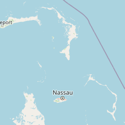
Understand where Lucayan National Park sits in Bahamas through a broader geographic reading of the surrounding landscape, nearby location context, and its mapped position within the national park landscape.

How Lucayan National Park fits into Bahamas

The Bahamas is an island nation in the Atlantic Ocean, forming part of the Lucayan Archipelago. It consists of more than 3,000 islands, cays and islets located north of Cuba, northwest of Hispaniola, and southeast of Florida. The country gained independence from Britain in 1973 and operates as a constitutional monarchy under King Charles III, with Nassau as its capital and largest city.

Wider geography shaping Lucayan National Park in Bahamas

The Bahamas occupies the Lucayan Archipelago in the Atlantic Ocean. The island chain is positioned north of Cuba, northwest of Hispaniola (shared by the Dominican Republic and Haiti), southeast of the US state of Florida, and east of the Florida Keys. The territory spans over 3,000 islands, cays and islets, with the total land area being 13,943 km². The Royal Bahamas Defence Force claims approximately 470,000 km² of surrounding ocean space.

Map view of Lucayan National Park

Use this park location map to pinpoint Lucayan National Park in Bahamas, understand its exact geographic position, and read its mapped placement within the surrounding landscape more clearly.

Pigeon | © OpenStreetMap contributors

Location context for Lucayan National Park

Grand Bahama
Park atlas

Expand your park discovery, comparing protected areas and regional parks within the geographic context of Lucayan National Park.

Compare Protected Areas and Nearby National Parks Around Lucayan National Park
After exploring Lucayan National Park, browse other national parks and protected areas across Grand Bahama Island and the wider Caribbean region. Comparing these protected landscapes provides valuable regional context, highlighting diverse coastal ecosystems and conservation efforts beyond Lucayan's unique cave systems.
National parkBahamas

Walker's Cay National Park: Bahamas National Park Featuring a Premier Barrier Reef Ecosystem

Explore mapped underwater geography and marine protected boundaries.

Walker's Cay National Park is a vital marine protected area located in the Bahamas, safeguarding approximately 3,840 acres of coastal and ocean waters. Its most distinguishing feature is the expansive barrier reef, a complex underwater geography teeming with diverse marine species that draws attention for diving and snorkeling. This park serves as a crucial element within the atlas of Bahamian protected lands, offering structured insights into marine conservation and the mapped distribution of critical reef habitats.

Area
16 km²
Established
2002
IUCN
II
Relief
Lowland
National parkNorth Abaco

Black Sound Cay National Reserve National Park: Protected Landscape in North Abaco

Explore its mapped boundaries and regional geographic context.

Black Sound Cay National Reserve is a key protected area situated in North Abaco, within the Bahamas. This national park offers a unique lens into the island's natural geography and conservation landscapes. Users can delve into the park's mapped outlines and understand its specific role within the broader Abaco Islands archipelago, providing critical geographic context for any atlas-based discovery.

Area
0.008 km²
Established
1988
IUCN
Ia
Relief
Lowland
National parkBahamas

Fowl Cays National Park: Bahamas Marine Protected Area and Coral Reef Atlas

Discover the mapped geography and marine ecosystems of this Bahamian national park.

Fowl Cays National Park in the Bahamas is a protected marine environment known for its significant coral reef formations and supporting seagrass meadows. This atlas-focused entry details the park's geographic setting within the Abaco Islands, highlighting its importance as a marine conservation landscape. Users can explore the protected boundaries and the ecological richness of this vital Caribbean ecosystem.

Area
9 km²
Established
2009
IUCN
II
Climate
Subtropical
National parkSouth Abaco

Abaco National Park: Bahamian National Park with Mapped Protected Landscape

Explore its geographic setting and protected area boundaries.

Abaco National Park stands as a designated national park within the Bahamas, contributing to the conservation of its unique protected landscapes. This entry provides detailed insights into its geographic positioning in South Abaco, focusing on the mapped extent of its protected area and its broader regional landscape context for atlas exploration.

Area
83 km²
Established
1994
Climate
Tropical
Scope
Terrestrial
Nature reserveHope Town

Tilloo Cay National Reserve Nature Reserve: Coastal Habitat for White-Tailed Tropicbirds

Mapped protected area within the Hope Town region of the Abacos.

Tilloo Cay National Reserve, a protected nature reserve situated near Hope Town, represents a significant habitat for the white-tailed tropicbird, a species reliant on such island nesting sites. This 11-acre reserve showcases a characteristic Bahamian small island ecosystem, featuring coastal terrain and scrub vegetation. Its protected status under the Bahamas National Trust ensures the security of critical breeding grounds, making it a key focus for conservation within the Abaco Islands. The reserve offers a distinct example of targeted habitat preservation, contributing to the broader atlas of protected natural landscapes in the Caribbean.

Area
0.04 km²
Established
1990
IUCN
II
Relief
Lowland
National parkBahamas

Pelican Cays Land and Sea Park: Protected Marine Landscape in the Bahamas

Explore coral reefs, undersea caves, and vital sea turtle habitats.

Pelican Cays Land and Sea Park, a protected national park in the Bahamas, offers a rich marine atlas experience. Its landscape is defined by extensive coral reef formations and unique undersea cave systems, supporting remarkable biodiversity. This park highlights the importance of protected waters for species like sea turtles and provides exceptional opportunities for exploring submerged geography and vibrant coral ecosystems.

Area
8 km²
Established
1972
IUCN
II
Relief
Lowland
National parkBahamas

Primeval Forest National Park: A Protected Landscape within the Bahamas Archipelago

Explore mapped boundaries and regional geography in the Lucayan Archipelago.

Primeval Forest National Park serves as a key protected area within the Bahamas, offering a focused view of island geography and conservation landscapes. This national park is a critical element for understanding the archipelago's natural terrain and mapped protected lands. Its presence provides valuable geographic context, allowing for detailed exploration of its boundaries and its place within the broader Bahamian atlas.

Established
2002
Relief
Mixed relief
Climate
Tropical
Access
Easy access
National parkBahamas

North and South Marine Parks National Park: Geographic Atlas and Protected Landscape in the Bahamas

Mapping Bahamian protected marine geography and its national park boundaries.

Delve into the atlas-view of North and South Marine Parks, a key national park in the Bahamas. This page details the park's specific geographic features and its protected landscape identity within the island nation. Understand its placement and significance as a protected marine area contributing to the regional geography.

Area
20 km²
Established
2002
IUCN
II
Climate
Tropical

Common questions about visiting, size, designation, and location context for Lucayan National Park

Lucayan National Park FAQs for park facts, access, geography, and protected area context
Find quick answers about Lucayan National Park, including protected-area facts, park geography, trail and visitor context, and how the park fits into its surrounding country and regional landscape.
MoriAtlas Explorer

Continue Your Protected Areas Search Across the Global Atlas

Deepen your exploration by continuing the structured search for national parks and protected areas worldwide. Utilize the comprehensive filtering capabilities to compare different conservation landscapes and refine your understanding of global park geography. Discover more about the distribution and characteristics of protected natural areas.

Global natural geography