Mori Atlas logo
National parkLukusuzi National Park

Mapping the protected area boundaries and geographic context of Lukusuzi National Park.

Lukusuzi National Park: Zambia's Protected National Park Landscape for Atlas Exploration

Lukusuzi National Park stands as a significant protected area within Zambia, offering a deep dive into the country's natural landscapes. This page serves as a canonical entry point for understanding the park's geographic identity, its mapped boundaries, and its role within Zambia's broader atlas of protected lands. Discover the fundamental landscape context that defines this important national park.

ZambiaEastern AfricaLuangwa ValleyNational ParkProtected AreaWildlife Conservation

Lukusuzi National Park

National park

Park overview

Structured park overview, official facts, and landscape profile for Lukusuzi National Park

Lukusuzi National Park park facts, protected area profile, and essential visitor context

Review the core facts for Lukusuzi National Park, including designation, size, terrain, visitor scale, habitats, and operating context in one park-focused overview.

About Lukusuzi National Park

Lukusuzi National Park is a protected natural area situated in the eastern Luangwa Valley region of Zambia. The park occupies a location within one of Africa's most significant wildlife ecosystems, characterized by diverse habitats that support substantial populations of large mammals and bird species. As an IUCN Category II protected area, the park is managed under national park status with the aim of preserving its ecological integrity while allowing for sustainable environmental tourism. The park's position in eastern Zambia places it within a broader conservation landscape that includes several other protected areas and wildlife management zones that collectively form an important corridor for migratory species and biodiversity preservation in the region.

Quick facts and research context for Lukusuzi National Park

Lukusuzi National Park is located in Zambia's eastern region within the Luangwa Valley, a well-known area for wildlife conservation and safari tourism. The park is classified as an IUCN Category II protected area, denoting its status as a national park with primary conservation objectives. The nearest population center is Chipata, which serves as a gateway for visitors traveling to the park. The geographic coordinates place the park at approximately 13 degrees south latitude and 32.5 degrees east longitude.

Protection and recognition

Exploring terrestrial designation boundaries and global conservation framework alignment.

Documented Protection Status and Conservation Profile of Lukusuzi National Park

Researchers and conservationists can explore the documented terrestrial protection status and formal boundaries of Lukusuzi National Park. Accessing verified geographic records and official designation facts helps establish the ecological placement of the park within regional protection frameworks.

Protection details

Protection scope
Terrestrial
Monthly climate preview

Analyzing long term historical temperature cycles and precipitation trends in Zambia

Lukusuzi National Park Climate Averages and Weather by Month Patterns

Long-term climate normals recorded at the park coordinate reveal a dry cycle with late-year temperatures peaking near 39 degrees Celsius alongside a distinct summer wet season. Accessing the complete monthly historical profile provides deeper geographic context on precipitation and temperature shifts across the landscape.
Annual mean23 °C
20 °C28 °C
Jan23°
Feb23°
Mar23°
Apr22°
May21°
Jun20°
Jul20°
Aug22°
Sep25°
Oct28°
Nov28°
Dec25°
Warmest month
November

28 °C

Coolest month
July

19.8 °C

Wettest month
January

8.2 mm/day

Driest month
July

0.1 mm/day

Park location guide

Geography guide, regional context, and park location map for Lukusuzi National Park

Lukusuzi National Park park geography, regions, and map view in Zambia

Understand where Lukusuzi National Park sits in Zambia through a broader geographic reading of the surrounding landscape, nearby location context, and its mapped position within the national park landscape.

How Lukusuzi National Park fits into Zambia

Zambia is a landlocked nation in Southern Africa with a population of approximately 20 million people. The country is bordered by eight countries and features diverse geography ranging from the Zambezi River to vast plateaus. Lusaka serves as the capital and largest city, while the Copperbelt Province in the north drives much of the economy through copper mining.

Wider geography shaping Lukusuzi National Park in Zambia

Zambia is located in Southern Africa and is landlocked, bordered by eight countries: Democratic Republic of the Congo to the north, Tanzania to the northeast, Malawi to the east, Mozambique to the southeast, Zimbabwe and Botswana to the south, Namibia to the southwest, and Angola to the west. The country features varied terrain including the Zambezi River plain in the south, plateaus in the central and northern regions, and the Muchinga Mountains in the northeast. Lake Tanganyika forms part of the northern border.

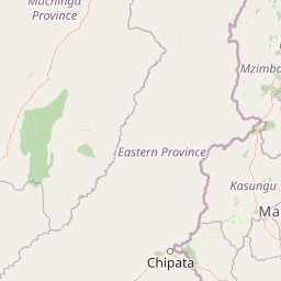
Map view of Lukusuzi National Park

Use this park location map to pinpoint Lukusuzi National Park in Zambia, understand its exact geographic position, and read its mapped placement within the surrounding landscape more clearly.

Pigeon | © OpenStreetMap contributors
Recorded earthquake history

View the Recorded Earthquake Catalogue for Lukusuzi National Park

Examine the historical seismic events documented near the boundaries of Lukusuzi National Park. This MoriAtlas collection offers data on event magnitude and depth, providing an objective look at the regional seismic history to support geographic discovery and research.

Lukusuzi National Park Earthquake History

Catalogued events

1 event

Strongest magnitude

Magnitude 4.6

Most recent event

Dec 16, 2001

This history includes earthquakes recorded inside the park or within 50 km of its borders

Park atlas

Explore the regional conservation landscape, comparing other national parks and protected areas surrounding Lukusuzi National Park.

Discover Nearby National Parks and Protected Areas Around Lukusuzi National Park

Explore other national parks and protected areas within Zambia's Eastern Luangwa Valley, extending beyond the specific boundaries of Lukusuzi National Park. Compare diverse conservation landscapes and understand the regional spread of protected zones, fostering a broader geographic appreciation of Africa's significant wildlife ecosystems.
National parkZambia
9.6 km away#1 closest

North

Luambe National Park: Detailed Geographic and Protected Area Atlas Information

Mapped landscape context within Zambia's natural regions.

This section provides an in-depth look at Luambe National Park, detailing its role as a protected area within the diverse geography of Zambia. Users can explore its mapped boundaries and understand its significance within the country's atlas of natural landscapes. The focus is on providing a concrete geographic perspective, essential for understanding how this national park fits into the regional conservation and landscape context of southern Africa.

Area
300 km²
IUCN
II
Relief
Upland
Climate
Tropical
National parkZambia
28 km away#2 closest

West

South Luangwa National Park: Zambia's National Park Geographic Atlas and Protected Landscape

Explore mapped boundaries and regional context within this Zambian protected area.

South Luangwa National Park represents a vital national park within Zambia, offering a distinct focal point for atlas-based geographic exploration. This dedicated entry details the park's mapped area and its integration into the surrounding Zambian geography. Users seeking to understand protected landscapes, regional park distributions, and natural terrain context will find South Luangwa National Park a key reference for detailed mapping and landscape analysis.

Area
9,050 km²
Established
1972
IUCN
II
Relief
Mixed relief
National parkMuchinga Province
36 km away#3 closest

Northwest

North Luangwa National Park: National Park Protected Landscape and Regional Geography

Mapped boundaries and geographic context within Muchinga Province.

North Luangwa National Park is a designated national park offering critical insights into Zambia's protected landscapes. This page provides an atlas-driven view of its geographic scope, emphasizing its mapped boundaries and its position within Muchinga Province. Explore the fundamental geography and protected area context that defines North Luangwa National Park for structured landscape discovery.

Area
4,636 km²
Established
1972
IUCN
II
Relief
Mixed relief
National parkMalawi
About 38 km away#4 closest

East

Kasungu National Park: Protected Landscape and Geographic Atlas of Central Malawi

Explore Miombo woodlands and dambo grasslands across its mapped terrain.

Kasungu National Park is a key protected area in Malawi, offering insights into the geography of Central Malawi's savanna landscapes. This national park, covering over 2,300 square kilometres, is defined by its characteristic Miombo woodland interspersed with dambo grasslands and riverine habitats. Its location near the Zambian border provides a critical conservation corridor, making it an important entity for understanding regional protected land distribution and landscape ecology within the atlas.

Area
2,316 km²
Established
1970
IUCN
II
Relief
Mixed relief
Nature reserveCentral Region
About 138 km away#5 closest

East

Ntchisi Mountain Forest Reserve: Geographic Overview and Protected Landscape Analysis

Nature reserve featuring isolated montane rainforest and high-elevation grassland in Malawi

Ntchisi Mountain Forest Reserve stands as a compact highland landmark within Malawi's Central Region, hosting a rare enclave of montane rainforest. This protected area offers an essential study in landscape zonation, where rift-influenced moisture supports diverse forest patches amidst a broader expanse of miombo woodland and montane grasses.

Area
97.12 km²
Established
1924
Relief
Mountain
Climate
Tropical
Wildlife reserveNorthern Region
About 138 km away#6 closest

Northeast

Chikangawa Forest Reserve: Mapping Malawi's Viphya Mountains Protected Wildlife Landscape

Explore montane forest ecosystems and exotic pine plantations

Chikangawa Forest Reserve stands as a major protected block within Malawi's Northern Region. The area covers extensive mountain ridges where native montane vegetation interweaves with significant man-made pine plantations. This geographic atlas entry provides insight into the reserve's role as a watershed protector and its unique position across the Viphya Plateau.

Area
1,147.8 km²
Established
1948
Relief
Mountain
Climate
Tropical
Wildlife reserveMalawi
About 142 km away#7 closest

Northeast

Nkhotakota Wildlife Reserve: Protected Geography and Rift Valley Landscapes

A vast, recovering miombo woodland sanctuary in central Malawi.

Nkhotakota Wildlife Reserve represents a massive conservation effort within the Great Rift Valley, protecting 1,800 square kilometres of steep ridges, riverine gorges, and dense woodland patches. This atlas entry details the reserve's unique topography, ranging from high-altitude escarpments down toward Lake Malawi, and its role as a pivotal site for large mammal restoration and bird diversity in Southeastern Africa.

Area
1,800 km²
IUCN
IV
Relief
Mixed relief
Climate
Tropical
National parkMuchinga Province
About 172 km away#8 closest

Northwest

Lavushi Manda National Park: Zambian National Park with Mapped Protected Boundaries

Discover its regional geography and landscape context.

Lavushi Manda National Park represents a distinct protected landscape within Muchinga Province, Zambia. This page provides detailed insights into its geographic identity, mapped park boundaries, and its placement within the broader regional terrain. Utilize this resource for structured atlas exploration of the park's natural context and its significance as a conservation area, offering a foundation for understanding its environmental setting.

Area
1,500 km²
Established
1972
IUCN
II
Relief
Mixed relief

Common questions about visiting, size, designation, and location context for Lukusuzi National Park

Lukusuzi National Park FAQs for park facts, access, geography, and protected area context

Find quick answers about Lukusuzi National Park, including protected-area facts, park geography, trail and visitor context, and how the park fits into its surrounding country and regional landscape.
MoriAtlas Explorer

Continue Your Protected Areas Search Across the Global Atlas

Deepen your exploration by continuing the structured search for national parks and protected areas worldwide. Utilize the comprehensive filtering capabilities to compare different conservation landscapes and refine your understanding of global park geography. Discover more about the distribution and characteristics of protected natural areas.

Global natural geography