Mori Atlas logo
Nature reserveMagadi Bird Sanctuary

Understanding the geography and protected boundaries of a key northern Karnataka bird habitat

Magadi Bird Sanctuary: An Essential Wetland Nature Reserve in the Karnataka Interior Landscape

Magadi Bird Sanctuary functions as a critical nature reserve centered on a traditional village tank in the Gadag District of Karnataka. This wetland habitat draws significant populations of migratory waterbirds including bar-headed geese and flamingos, which rely on the shallow waters and adjacent agricultural fields. The geography of the reserve reflects a transition between arid inland terrain and vital aquatic ecosystems, showcasing how a managed rural water body serves as a recognized regional biodiversity hotspot.

bird sanctuarywetlandvillage tankmigratory birdsbar-headed goosewaterbirds

Magadi Bird Sanctuary

Nature reserve

Park overview

Structured park overview, official facts, and landscape profile for Magadi Bird Sanctuary

Magadi Bird Sanctuary park facts, protected area profile, and essential visitor context

Review the core facts for Magadi Bird Sanctuary, including designation, size, terrain, visitor scale, habitats, and operating context in one park-focused overview.

About Magadi Bird Sanctuary

Magadi Bird Sanctuary is a wetland-centered protected area in Gadag District, northern Karnataka, centered on the Magadi tank near the village of Magadi in Shirhatti Taluk. Although the surrounding region is largely semi-arid and agricultural, the reservoir and its margins create a compact but ecologically lively refuge for waterbirds, earning the site recognition as one of Karnataka's smaller biodiversity hotspots.

The sanctuary lies along the Gadag to Bangalore road corridor, around 26 kilometers from Gadag, 8 kilometers from Shirhatti and 11 kilometers from Lakshmeshwar, placing it within the wider farming landscape of interior Karnataka. The protected area covers approximately 134 acres, while the broader catchment that feeds the wetland spans roughly 900 hectares. This combination of a relatively small sanctuary footprint and a much larger agricultural catchment plays a central role in shaping both the bird life and the management challenges of the site.

Management responsibility is shared between the Department of Fisheries of the Government of Karnataka, which oversees tank fisheries, and the village panchayat of Magadi. The institutional blending of fisheries, local governance, and wildlife protection gives Magadi Bird Sanctuary a character that is quite different from a typical large forest reserve; it is essentially a working rural tank whose biodiversity value has been formally recognized and protected. Academic support for ornithological study comes from Karnatak University, which uses the area as a site for bird research.

In ecological terms, Magadi represents the kind of village-scale wetland that has become increasingly important for migratory waterbirds across peninsular India. Its seasonal congregations of bar-headed geese, herons, storks, ibises and other waterbirds turn a modest inland tank into a meaningful node in the regional network of bird habitats.

Quick facts and research context for Magadi Bird Sanctuary

Magadi Bird Sanctuary is located in Gadag District of northern Karnataka, India, within Magadi village in Shirhatti Taluk. The protected area is built around the Magadi tank, a traditional village reservoir that supports both fisheries and wildlife.

The sanctuary covers roughly 134 acres of land, with a broader catchment area of about 900 hectares that links the wetland to surrounding agricultural land. Administratively, the tank falls under the joint oversight of the Department of Fisheries of the Government of Karnataka and the village panchayat of Magadi.

Protection and recognition

Documented terrestrial protection framework and management context for Magadi Bird Sanctuary

Magadi Bird Sanctuary Protection Status and Conservation Scope

Magadi Bird Sanctuary maintains a documented terrestrial protection scope and defined conservation designation framework. Structured records outline the verified administrative status and recognized management parameters governing the protected area.

Protection details

Protection scope
Terrestrial
Transboundary protection
No
Park context

Deeper park guide and search-rich context for Magadi Bird Sanctuary

Magadi Bird Sanctuary history, landscape, wildlife, and travel context

Explore Magadi Bird Sanctuary through its history, landscape character, ecosystems, wildlife, conservation priorities, cultural context, and seasonal travel timing in a structured park guide built for atlas discovery and search intent.

Why Magadi Bird Sanctuary stands out

Magadi Bird Sanctuary is best known as a seasonal refuge for migratory waterbirds in the otherwise dry landscape of northern Karnataka. The bar-headed goose is the most emblematic visitor, travelling long distances to winter on the Magadi wetlands, joined by herons, storks, ibises, ducks, flamingos and other waterbirds. The sanctuary is also notable for the way a working village tank, actively used for fisheries, doubles as one of the state's small but recognized biodiversity hotspots. The interaction between migratory birds and nearby agriculture, where wintering birds occasionally feed on barley, rice and wheat, is a defining feature of the site.

Magadi Bird Sanctuary history and protected-area timeline

Magadi Bird Sanctuary developed around the Magadi tank, a long-standing village reservoir in Magadi of Shirhatti Taluk, Gadag District. The tank has historically served the local community as a source of water and as the foundation for fisheries managed through the village panchayat and the Department of Fisheries, Government of Karnataka.

Over time, the reservoir's role expanded beyond fisheries and local water supply as migratory and resident waterbirds began using the tank and its margins in significant numbers. The site's biodiversity value eventually led to its recognition as one of Karnataka's biodiversity hotspots and to its formal designation as a bird sanctuary, while fisheries and panchayat oversight of the tank continued alongside its conservation role.

Local academic engagement, particularly through Karnatak University, has added a research dimension to the sanctuary's recent history, supporting ongoing study of the bird populations that depend on the Magadi wetlands.

Magadi Bird Sanctuary landscape and geographic character

The landscape of Magadi Bird Sanctuary is shaped by water rather than by relief. At its heart is the Magadi tank, an open expanse of standing water set within the gently undulating, largely agricultural terrain of northern Karnataka. Surrounding the tank are tank margins, wet soils, reed patches and adjacent croplands that together make up the wider catchment of roughly 900 hectares.

The scenery around the sanctuary is characteristic of interior Karnataka: dry, open countryside punctuated by fields of barley, rice and wheat in season, small villages including Magadi itself, and the broader road-linked landscape between Gadag, Shirhatti and Lakshmeshwar. Rather than dramatic landforms, the visual interest of the area comes from the contrast between the arid-feeling surroundings and the cool, bird-rich surface of the tank, particularly during the winter when migratory species arrive in numbers.

Magadi Bird Sanctuary ecosystems, habitats, and plant life

Ecologically, Magadi is a wetland sanctuary embedded in a dry-region agricultural matrix. The Magadi tank and its fringing habitat support a mix of aquatic, semi-aquatic and terrestrial vegetation typical of small village reservoirs in northern Karnataka, while the surrounding catchment provides open farmland and seasonal stubble that birds also exploit.

The site functions as a compact but productive biodiversity node, combining fish populations, amphibians, molluscs and aquatic insects that sustain waterbirds, with surrounding crops that, in winter, supplement the diet of migratory species. This intersection of aquatic and agricultural habitats is central to the ecological identity of the sanctuary, and is what allows the relatively small 134-acre protected area to support such a varied bird community within a broader 900-hectare catchment.

Magadi Bird Sanctuary wildlife and species highlights

Wildlife interest at Magadi Bird Sanctuary centers on birds, especially waterbirds that gather on and around the tank. The most iconic visitor is the bar-headed goose, which migrates long distances to winter on the Magadi wetlands and has become closely associated with the site.

Alongside the bar-headed goose, recorded species include the grey heron, purple heron, comb duck, oriental ibis, white-breasted waterhen, greater flamingo, black-winged stilt, cattle egret, Asian openbill stork, woolly-necked stork, painted stork, Eurasian spoonbill and the ruddy shelduck, also known as the Brahmini duck. These species reflect a typical mix of waders, herons, ibises, storks, ducks and flamingos that use shallow inland tanks in this part of India.

Typical waterbird prey at Magadi includes fish, amphibians, molluscs and snakes. A distinctive local behavior is the way migratory birds also feed on agricultural produce during winter, taking barley, rice and wheat from nearby fields and at times causing crop damage, which highlights how closely the sanctuary's bird life is tied to the surrounding farmed landscape.

Magadi Bird Sanctuary conservation status and protection priorities

From a conservation perspective, Magadi Bird Sanctuary matters because it formalizes protection around a modest but ecologically valuable village tank in an otherwise dry and heavily cultivated region. Recognized as one of Karnataka's biodiversity hotspots, the site illustrates how small, locally managed wetlands can contribute meaningfully to regional bird conservation, especially for migratory waterbirds.

The sanctuary's protection also extends beyond the 134-acre core to a catchment of about 900 hectares, recognizing the link between the tank, its bird life and the surrounding agricultural land. Shared oversight between the Department of Fisheries, the village panchayat, and supporting institutions such as Karnatak University gives the site an integrated management approach that combines fisheries, local governance and biodiversity monitoring, helping sustain the Magadi wetlands as a refuge for resident and migratory species.

Magadi Bird Sanctuary cultural meaning and human context

Magadi Bird Sanctuary is closely tied to the rural life of Magadi village in Shirhatti Taluk, where the tank has long been a shared community resource. The presence of a village panchayat as a co-manager of both fisheries and the sanctuary reflects the deep local roots of the water body, with bird conservation layered onto traditional uses of the tank rather than replacing them.

The surrounding landscape of small villages, agricultural fields and road links between Gadag, Shirhatti and Lakshmeshwar gives the sanctuary a strong sense of place within interior Karnataka, while academic engagement through Karnatak University links the site to wider regional traditions of natural history study.

Top sights and standout views in Magadi Bird Sanctuary

Magadi Bird Sanctuary stands out for the way a single traditional village tank supports a rich winter congregation of migratory waterbirds in an otherwise dry, farmed landscape. The sanctuary's scale is modest at about 134 acres, but its catchment of around 900 hectares and its recognition as a Karnataka biodiversity hotspot give it an outsized ecological role.

The site's combination of bar-headed geese, herons, storks, ibises, flamingos and shelducks, set against a backdrop of working fisheries and croplands, makes Magadi a compact but distinctive example of how rural wetlands sustain both local livelihoods and regional biodiversity.

Best time to visit Magadi Bird Sanctuary

Magadi Bird Sanctuary is most rewarding to experience during the winter months, when migratory waterbirds, including the emblematic bar-headed goose, arrive on the Magadi wetlands. Cooler, drier conditions also make the open tank margins and surrounding agricultural landscape easier and more pleasant to explore, while the congregation of waders, herons, storks and ducks is at its seasonal peak.

Monthly climate preview

Long-term average monthly temperature and precipitation data for Karnataka

Magadi Bird Sanctuary Climate Normals and Annual Temperature Patterns

Magadi Bird Sanctuary exhibits a measured annual cycle of changing monthly temperatures and precipitation rates based on historical coordinate records. Examining the complete twelve-month climate profile reveals detailed long-term averages across all seasons.
Annual mean25 °C
22 °C30 °C
Jan23°
Feb26°
Mar29°
Apr30°
May29°
Jun26°
Jul25°
Aug24°
Sep24°
Oct24°
Nov23°
Dec22°
Warmest month
April

30.3 °C

Coolest month
December

22 °C

Wettest month
July

4.4 mm/day

Driest month
January

0 mm/day

Park location guide

Geography guide, regional context, and park location map for Magadi Bird Sanctuary

Magadi Bird Sanctuary park geography, regions, and map view in India

Understand where Magadi Bird Sanctuary sits in India through a broader geographic reading of the surrounding landscape, nearby location context, and its mapped position within the national park landscape.

How Magadi Bird Sanctuary fits into India

India is a South Asian country bordered by the Indian Ocean, Arabian Sea, and Bay of Bengal. It shares land borders with Pakistan, China, Nepal, Bhutan, Bangladesh, and Myanmar. The country has a population of over 1.4 billion people and operates as a federal parliamentary republic with its capital in New Delhi.

Wider geography shaping Magadi Bird Sanctuary in India

India occupies the Indian subcontinent in South Asia, bordered by the Arabian Sea to the southwest, the Bay of Bengal to the southeast, and the Indian Ocean to the south. It shares land borders with Pakistan to the west, China, Nepal, and Bhutan to the north, and Bangladesh and Myanmar to the east. The territory also includes the Andaman and Nicobar Islands in the Indian Ocean.

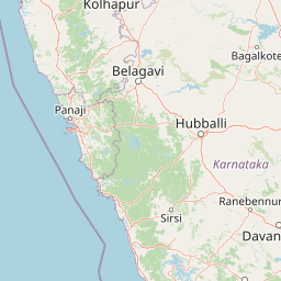
Map view of Magadi Bird Sanctuary

Use this park location map to pinpoint Magadi Bird Sanctuary in India, understand its exact geographic position, and read its mapped placement within the surrounding landscape more clearly.

Pigeon | © OpenStreetMap contributors

Location context for Magadi Bird Sanctuary

Karnataka
Park atlas

Compare surrounding regional geography and connected wetland habitats

Other Parks and Protected Areas Near Magadi Bird Sanctuary

Browse protected areas and wetland reserves located across the surrounding regional terrain. Compare adjacent natural habitats to understand the broader ecological network connected to Magadi Bird Sanctuary.
National parkIndia
About 123 km away#1 closest

West

Anshi National Park in India: Mapped Protected Area and Regional Geography

Understanding India's protected landscapes and natural terrain.

Anshi National Park stands as a significant protected area within India, contributing to the nation's network of conservation landscapes. This park offers valuable data for understanding its mapped boundaries, terrain characteristics, and overall geographic position within the Indian subcontinent. Its designation as a national park underscores its importance for regional geography and structured landscape discovery.

Established
1987
Relief
Highland
Climate
Tropical
Access
Moderate access
National parkIndia
About 136 km away#2 closest

West

Mollem National Park National Park: Geographic Context and Protected Landscape Exploration in India

Discover mapped terrain and biodiversity within the Western Ghats.

Delve into the specifics of Mollem National Park, a protected area renowned for its spectacular Dudhsagar Falls and the historic Tambdi Surla Mahadev Temple. This page provides detailed geographic context, showcasing the park's steep, forested slopes and its significance as part of the Western Ghats biodiversity hotspot. Understand the park's unique landscape, from its role as a critical watershed to its function as a habitat for diverse flora and fauna, offering rich material for atlas exploration and geographic appreciation of this Indian natural landmark.

IUCN
II
Wildlife reserveGoa
About 150 km away#3 closest

West

Nanda Lake Wildlife Reserve: Wetland Geography and Protected Landscapes in Goa, India

A Ramsar-designated freshwater refuge in the Western Ghats foothills

Nanda Lake stands as a compact yet ecologically significant freshwater wetland in Goa. Recognized under the Ramsar Convention, this wildlife reserve preserves a rare piece of the Konkan coast's natural freshwater terrain, providing essential habitat for migratory birds and native aquatic species within a heavily human-influenced regional landscape.

Area
0.42 km²
Established
2022
Relief
Lowland
Water
Water-dominated
Watercolor painting showing a landscape with rolling hills, forests, and distant mountains
National parkKarnataka
About 195 km away#4 closest

South

Kudremukh National Park: Karnataka's Protected Landscape and River Origin

Explore the geography of shola forests and grasslands.

Kudremukh National Park is a pivotal protected landscape in Karnataka, India, recognized for its distinctive montane grasslands and shola forests. This national park is a critical source for three major rivers: the Tunga, Bhadra, and Nethravathi, highlighting its ecological and geographic significance within the Western Ghats. The park's terrain features rolling hills and steep western slopes, contributing to its unique biodiversity and landscape character for atlas-based discovery.

Area
600.57 km²
Established
1987
IUCN
II
Relief
Mountain
National parkIndia
About 287 km away#5 closest

Northwest

Chandoli National Park: A National Park within India's Protected Lands Atlas

Mapped boundaries and regional landscape context for this protected area.

Chandoli National Park represents a distinct protected area within India, offering specific insights into national park landscapes and their geographic distribution. This entry focuses on its identity as a national park, detailing its mapped boundaries and regional context. It serves as a critical point for understanding the park's landscape within the atlas, providing factual geographic information for exploration and comparative study.

Area
317.67 km²
Established
2004
IUCN
II
Relief
Mountain
Wildlife reserveAndhra Pradesh
About 313 km away#6 closest

East

Rollapadu Wildlife Sanctuary: Mapping the Protected Grassland Landscapes of Andhra Pradesh

A vital semi-arid wildlife reserve and avian conservation zone.

Rollapadu Wildlife Sanctuary provides a focused look at the environmental challenges facing semi-arid grassland ecosystems in southern India. Home to the great Indian bustard and diverse wintering waterbirds, this protected area illustrates the intricate relationship between scrub forest patches, open grazing lands, and the surrounding agricultural periphery in the Nandyal district.

Area
6.14 km²
Established
1988
IUCN
IV
Relief
Upland
National parkAndhra Pradesh
About 332 km away#7 closest

East

Rajiv Gandhi National Park (Rameswaram) National Park: Exploring Andhra Pradesh's Protected Landscapes

Mapped geography and protected area context for Rajiv Gandhi National Park (Rameswaram).

Delve into the geographic identity of Rajiv Gandhi National Park (Rameswaram), a key protected area within Andhra Pradesh. This detail page serves as an atlas anchor for understanding the park's landscape, mapped features, and its significance as a national park. Users can explore its protected boundaries and appreciate its role within the regional geography of Andhra Pradesh.

Area
2.4 km²
Established
2005
IUCN
II
Relief
Lowland
Watercolor illustration showing mountains, a winding river, and green vegetation
National parkKarnataka
About 348 km away#8 closest

Southeast

Bannerghatta National Park: A National Park in Karnataka with Mapped Geographic Identity

Explore the protected landscape and regional terrain context.

Bannerghatta National Park is an important protected area within the state of Karnataka, India. Its designation as a national park signifies its role in preserving regional natural landscapes and providing valuable geographic context for atlas exploration. Users can examine its mapped boundaries and understand its placement within the diverse terrain characteristic of South India and the Western Ghats, contributing to a structured understanding of protected lands.

Area
260.51 km²
Established
1974
IUCN
II
Relief
Mountain

Common questions about visiting, size, designation, and location context for Magadi Bird Sanctuary

Magadi Bird Sanctuary FAQs for park facts, access, geography, and protected area context

Find quick answers about Magadi Bird Sanctuary, including protected-area facts, park geography, trail and visitor context, and how the park fits into its surrounding country and regional landscape.
MoriAtlas Explorer

Continue Your Protected Areas Search Across the Global Atlas

Deepen your exploration by continuing the structured search for national parks and protected areas worldwide. Utilize the comprehensive filtering capabilities to compare different conservation landscapes and refine your understanding of global park geography. Discover more about the distribution and characteristics of protected natural areas.

Global natural geography