

Mori Atlas logo
National parkMarsabit National Park

Explore the mapped boundaries and natural terrain of this Kenyan National Park.

Marsabit National Park: Protected Landscape and Geographic Context in Marsabit County, Kenya

(Marsabit National Reserve)

Marsabit National Park stands as a significant protected area within Marsabit County, Kenya, offering a distinct geographic focus for atlas exploration. This page serves as the authoritative entry point for understanding the park's identity as a national park, its mapped boundaries, and its contribution to the region's natural landscape context. Users can delve into the park's place within the broader geography of northern Kenya, appreciating its role in a structured discovery platform dedicated to protected lands.

Forest ecosystemVolcanic cratersElephant habitatBird sanctuaryMountain wildlifeNorthern Kenya

Marsabit National Park

National park

Park overview

Structured park overview, official facts, and landscape profile for Marsabit National Park

Marsabit National Park park facts, protected area profile, and essential visitor context
Review the core facts for Marsabit National Park, including designation, size, terrain, visitor scale, habitats, and operating context in one park-focused overview.

About Marsabit National Park

Marsabit National Park represents one of Kenya's most distinctive protected areas, situated on the slopes and summit of Mount Marsabit, an extinct volcanic mountain rising dramatically from the semi-arid plains of northern Kenya. The landscape is characterized by a series of volcanic craters, many of which are blanketed in dense forest, creating a lush green oasis amid otherwise arid terrain. The park's most famous feature is Lake Paradise, a crater lake nestled in the northern section known as Gof Sokorte Gurda, where dramatic cliffs provide habitat for numerous bird species. The forest ecosystem of Mount Marsabit contrasts sharply with the dusty plains below, featuring strangler figs and acacia-lined tracks described by observers as a stark juxtaposition between mountain forest and savanna. The reserve serves as a critical wildlife habitat in Kenya's northern region, supporting substantial populations of megafauna including elephants, giraffes, buffaloes, and lions, alongside diverse primate communities and an impressive bird population.

Quick facts and research context for Marsabit National Park

Marsabit National Park occupies a mountainous volcanic landscape in Marsabit County, formerly part of Kenya's Eastern Province. The reserve was established in 1949 and covers 1,554 square kilometers around Mount Marsabit, an extinct volcanic mountain with multiple crater lakes. The park is characterized by forest-covered volcanic craters rising from semi-arid surrounding plains, creating a distinctive island ecosystem. It is noted for substantial zebra populations and serves as an important bird sanctuary with approximately 350 recorded bird species, including 52 species of birds of prey.

Park context

Deeper park guide and search-rich context for Marsabit National Park

Marsabit National Park history, landscape, wildlife, and travel context
Explore Marsabit National Park through its history, landscape character, ecosystems, wildlife, conservation priorities, cultural context, and seasonal travel timing in a structured park guide built for atlas discovery and search intent.

Why Marsabit National Park stands out

Marsabit National Park is best known for its remarkable elephant populations, which achieved international fame in the 1970s for possessing the longest tusks of any elephants in the world. The park's most celebrated resident was Ahmed, an elephant whose tusks weighed over 300 kilograms and who was placed under constant surveillance during his lifetime. Beyond elephants, the park is distinguished by its forest-covered volcanic craters, the dramatic cliffs of Lake Paradise in Gof Sokorte Gurda, and a bird sanctuary supporting diverse raptor species and waterfowl around its crater lakes.

Marsabit National Park history and protected-area timeline

Marsabit National Park was established in 1949, making it one of Kenya's older protected areas established during the colonial era. The reserve was created to protect the unique forest ecosystem of Mount Marsabit and its wildlife, particularly the significant elephant populations that inhabited the area. In the 1970s, the park gained international attention for its elephant population, which was reputed to include individuals with the longest tusks in the world. The most famous of these was Ahmed, an elephant that became a symbol of the park's conservation significance and was reportedly placed under constant surveillance to protect him from poaching. The establishment of the park predates Kenya's independence and represents an early effort to preserve the country's natural heritage in the northern frontier regions.

Marsabit National Park landscape and geographic character

The landscape of Marsabit National Park is defined by its volcanic origins, featuring multiple extinct volcanic craters that dot the mountain and surrounding area. The most prominent of these is the Gof Redo crater, situated approximately 5 kilometers north of Marsabit town at the fork of roads leading to Moyale and North Horr. These craters are largely covered in forest, creating a verdant landscape that contrasts dramatically with the surrounding semi-arid plains. The terrain rises from the lower slopes marked by scrubland through dense forest to the crater rims and lake basins. The dramatic cliffs of Gof Sokorte Gurda above Lake Paradise provide the park's most striking topographic feature, dropping away to create a visually spectacular setting. The forest-covered volcanic cones create an island ecosystem of significant topographic and ecological distinction in northern Kenya.

Marsabit National Park ecosystems, habitats, and plant life

The nature of Marsabit National Park centers on its unique forest ecosystem developing on volcanic soils at elevation, creating conditions quite different from the surrounding lowland plains. The park's forests support diverse primate communities including black and white colobus monkeys, blue monkeys, olive baboons, and vervet monkeys. The forest floor and surrounding scrubland support populations of bushbucks, sunis, Peter's gazelles (a subspecies of Grant's gazelle), and beisa oryxes. The volcanic craters and lake systems create additional habitat diversity, supporting waterfowl and wetland species. The forest ecosystem represents a critical isolated habitat in northern Kenya, supporting species more typical of highland or more humid regions than would be expected given the surrounding semi-arid conditions.

Marsabit National Park wildlife and species highlights

Marsabit National Park supports a diverse mammalian fauna characteristic of both forest and savanna environments. The park is particularly famous for its elephants, historically noted for their exceptionally long tusks, with the legendary Ahmed achieving international fame. Other megafauna include lions, giraffes, and buffaloes. Primate species are well represented with black and white colobus, blue monkeys, olive baboons, and vervet monkeys all present. Smaller mammals include bushbucks, sunis, Peter's gazelles, beisa oryxes, striped hyenas, caracals, and aardwolves. The bird population is particularly impressive with approximately 350 species recorded, including 52 birds of prey. The cliffs of Lake Paradise support populations of Rüppell's griffon vultures, peregrine falcons, mountain buzzards, black kites, and African fish eagles, while the lake itself hosts ducks including garganeys, southern pochards, and teals, alongside red-knobbed coots, hamerkops, ibises, purple herons, and yellow-billed storks. The surrounding areas feature sociable weaver birds with their distinctive neat nests, sparrow weavers, and white-bellied turacos.

Marsabit National Park conservation status and protection priorities

Marsabit National Park serves as an important conservation area in northern Kenya, protecting a unique forest ecosystem on an isolated volcanic mountain. The park's significance is amplified by its position as a habitat island in a largely semi-arid landscape, making it crucial for species that require forest habitats. The park's elephant population, particularly the historic presence of exceptionally long-tusked individuals like Ahmed, has drawn attention to its conservation importance. The bird sanctuary designation reflects the site's importance for both resident and migratory bird species, particularly the diverse raptor community and waterfowl using the crater lakes. The Kenya Wildlife Service maintains management responsibility for the reserve, working to protect both the forest ecosystems and the wildlife populations they support.

Marsabit National Park cultural meaning and human context

Marsabit National Park is located in Marsabit County, an area inhabited by various indigenous communities traditionally associated with pastoralist livelihoods. The park's name derives from the town of Marsabit, which serves as the nearest urban center and regional hub for the surrounding area. The mountain and surrounding region have historical significance for local communities, though the park's protected status restricts human settlement within its boundaries. The area represents a boundary zone between highland and lowland ecosystems that has shaped both ecological patterns and human land use patterns in northern Kenya.

Top sights and standout views in Marsabit National Park

The most celebrated highlight of Marsabit National Park is its association with some of the world's longest-tusked elephants, most notably Ahmed. The forest-covered volcanic craters, particularly the dramatic Gof Redo crater and the scenic Lake Paradise in Gof Sokorte Gurda, provide the park's most distinctive landscapes. The bird cliffs of Gof Sokorte Gurda support impressive raptor populations including Rüppell's griffon vultures and peregrine falcons. The contrast between the lush mountain forest with its strangler figs and the dusty savanna plains below creates a visually striking environment. The approximately 350 bird species recorded in the park make it a significant destination for birdwatching in northern Kenya.

Best time to visit Marsabit National Park

Marsabit National Park can be visited year-round, though the best conditions typically occur during the dry seasons when wildlife viewing is more predictable and roads are more accessible. The dry seasons from December through March and June through September offer optimal conditions for viewing elephants, giraffes, and other wildlife as animals concentrate around water sources. The mountain forest remains verdant throughout the year due to higher moisture levels at elevation, and the bird population is present in all seasons. The wet seasons may make some roads more difficult to navigate but also bring lush vegetation and potentially better photography conditions.

Park location guide

Geography guide, regional context, and park location map for Marsabit National Park

Marsabit National Park park geography, regions, and map view in Kenya
Understand where Marsabit National Park sits in Kenya through a broader geographic reading of the surrounding landscape, nearby location context, and its mapped position within the national park landscape.

How Marsabit National Park fits into Kenya

Kenya is a presidential republic in East Africa and the seventh-most populous country on the continent. Its capital is Nairobi, and it borders five countries and the Indian Ocean. The country features significant geographic diversity including Mount Kenya, the Rift Valley, and coastal regions.

Wider geography shaping Marsabit National Park in Kenya

Kenya is located in East Africa, bordering South Sudan to the northwest, Ethiopia to the north, Somalia to the east, Tanzania to the southwest, and Uganda and Lake Victoria to the west. The southeastern border meets the Indian Ocean. The geography includes the Rift Valley highlands with Mount Kenya, coastal plains, and northern arid regions.

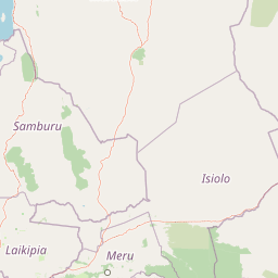
Map view of Marsabit National Park

Use this park location map to pinpoint Marsabit National Park in Kenya, understand its exact geographic position, and read its mapped placement within the surrounding landscape more clearly.

Pigeon | © OpenStreetMap contributors

Location context for Marsabit National Park

Marsabit County
Park atlas

Trace connected protected landscapes and the broader regional geography surrounding Marsabit Mountain

Compare National Parks and Protected Areas Near Marsabit National Park in Kenya's Northern Frontier
After exploring Marsabit National Park's unique volcanic forests and elephant habitats, browse nearby national parks and other significant protected areas across Kenya's northern frontier region. Compare diverse protected landscapes, trace the regional spread of conservation efforts, and find adjacent geographic zones for continued atlas-style exploration.
National parkOromia Region

Borana National Park National Park: Geographic Context and Protected Landscape Atlas

Explore the mapped boundaries and regional geography.

Gain a detailed understanding of Borana National Park, identified as a national park within the Oromia Region of Ethiopia. This entry focuses on its geographic context, providing mapped information crucial for understanding its protected landscape identity. Examine how Borana National Park fits into the broader atlas of conservation areas, offering a precise view of its unique terrain and regional significance without operational details.

Area
45,366 km²
Established
1986
IUCN
II
Relief
Mountain
National parkRift Valley Province

Sibiloi National Park: National Park with Mapped Geographic Boundaries

Explore the protected landscape of Rift Valley Province.

Sibiloi National Park is a designated national park offering a distinct protected landscape within the broader geographic region of Rift Valley Province, Kenya. This entry focuses on its mapped boundaries and its identity as a key area for conservation, providing a structured view for geographic atlas exploration. Understand the foundational elements of Sibiloi National Park's protected status and its place within regional natural landscapes.

Area
1,570.85 km²
Established
1973
IUCN
II
Relief
Mixed relief
National parkEastern Province

Meru National Park National Park: Mapped Protected Boundaries and Eastern Province Geography

Explore regional landscape context and natural terrain.

Meru National Park represents a vital national park entity within the Eastern Province of Kenya, offering unique opportunities for structured geographic and atlas exploration. This page details its protected landscape identity, emphasizing mapped boundaries and the surrounding regional context. Users interested in conservation lands and natural terrain can find comprehensive details on Meru National Park's geographic significance and its role within the broader atlas of protected areas.

Area
870.44 km²
Established
1966
IUCN
II
Relief
Upland
National parkKenya

Mount Kenya National Park: Mapped Volcanic Landscape & Protected Area Geography

Kenya's high-altitude Afro-alpine ecosystems and mapped park boundaries.

Mount Kenya National Park safeguards a globally significant volcanic landscape and vital water resources for Kenya. This protected area above 3,000 meters features dramatic peaks, glaciers, and distinctive Afro-alpine flora. Explore its comprehensive mapped boundaries, understand its regional geographic importance, and discover the unique ecosystems that define this exceptional national park through detailed atlas context.

Area
715 km²
Established
1949
IUCN
II
Relief
Mountain
National parkTana River County

Kora National Park: A Unique Protected Landscape in Tana River County, Kenya

Explore its inselberg geography and mapped natural terrain.

Kora National Park represents a remarkable protected area characterized by its striking inselberg topography and semi-arid bushland, set against the backdrop of the Tana River. This national park in Tana River County offers a unique geographic profile, featuring massive granite formations that punctuate the expansive terrain. Discover the mapped boundaries and the distinctive landscape that make Kora National Park a significant entity for regional atlas exploration and understanding protected lands in eastern Africa.

Area
1,788 km²
Established
1989
IUCN
II
Relief
Mixed relief
National parkNyeri County

Aberdare National Park: Mapped Protected Landscape in Nyeri County

National Park Geography and Atlas Context

Aberdare National Park is a protected national park located within Nyeri County, Kenya. This entry offers detailed geographic information and map context, highlighting its protected boundaries and landscape characteristics. Users can explore its regional setting, understand its specific terrain features, and discover its significance as a conservation area within the Kenyan geography. Access structured data that clarifies the park's identity as a vital protected landscape.

Area
767 km²
Established
1950
IUCN
II
Relief
Mountain
National parkTrans-Nzoia County

Saiwa Swamp National Park National Park: Mapped Protected Area in Trans-Nzoia County

Explore the geographic context and protected landscape features.

Saiwa Swamp National Park serves as a vital national park within Trans-Nzoia County, Kenya, offering a unique perspective on protected lands. This page details its mapped geography and landscape characteristics, providing essential context for atlas-based exploration of its protected boundaries and regional setting. Understand the specific features that define this important conservation area.

Area
3 km²
Established
1974
IUCN
II
Relief
Lowland
National parkMandera County

Malka Mari National Park: Remote Frontier Protected Landscape and Dawa River Ecosystem

Explore the semi-arid bushland and riparian woodland geography.

Malka Mari National Park offers a profound wilderness experience as Kenya's most remote national park, situated along the Dawa River in Mandera County. This protected area features striking contrasts between arid bushland and verdant riparian woodlands, supporting unique plant species and wildlife adapted to the semi-arid environment. Its vast, undeveloped character makes it a significant site for frontier conservation and a unique destination for atlas-style landscape exploration.

Area
1,500 km²
Established
1989
IUCN
II
Climate
Arid

Common questions about visiting, size, designation, and location context for Marsabit National Park

Marsabit National Park FAQs for park facts, access, geography, and protected area context
Find quick answers about Marsabit National Park, including protected-area facts, park geography, trail and visitor context, and how the park fits into its surrounding country and regional landscape.
MoriAtlas Explorer

Continue Your Protected Areas Search Across the Global Atlas

Deepen your exploration by continuing the structured search for national parks and protected areas worldwide. Utilize the comprehensive filtering capabilities to compare different conservation landscapes and refine your understanding of global park geography. Discover more about the distribution and characteristics of protected natural areas.

Global natural geography