Mori Atlas logo
National parkMayflower Bocawina National Park

Discover the geographic setting and mapped boundaries of this natural and cultural heritage site.

Mayflower Bocawina National Park: Protected Tropical Forest, Waterfalls & Maya Atlas

Mayflower Bocawina National Park represents a significant protected natural area within Belize's Stann-Creek District, encompassing approximately 7,000 acres of dense tropical rainforest. This national park is celebrated for its striking natural features, including three distinct waterfalls cascading through mountainous terrain, alongside the captivating remnants of ancient Maya structures such as the temples at Maintzunun and T'au Witz. Its designation underscores its ecological importance and cultural heritage, offering a unique lens through which to explore Belize's natural landscapes and regional geography.

Tropical ForestWaterfallsMaya Archaeological SitesBirdwatchingWildlife ConservationCentral America

Mayflower Bocawina National Park

National park

Park overview

Structured park overview, official facts, and landscape profile for Mayflower Bocawina National Park

Mayflower Bocawina National Park park facts, protected area profile, and essential visitor context

Review the core facts for Mayflower Bocawina National Park, including designation, size, terrain, visitor scale, habitats, and operating context in one park-focused overview.

About Mayflower Bocawina National Park

Mayflower Bocawina National Park represents an important protected area in Belize's southern region, established in 2001 to preserve both ecological systems and cultural heritage. The park occupies a substantial tract of approximately 7,000 acres within the Stann-Creek District, accessible via the Southern Highway at roughly the six-mile marker. The terrain consists of dense tropical forest with mountainous areas that support the park's waterfall systems. Management responsibility falls to the Friends of Mayflower Bocawina National Park, an organization dedicated to conservation and sustainable use of the area's resources. The park's Category II designation under the IUCN protected area classification indicates its primary purpose of protecting natural ecosystems while allowing controlled visitor access for environmental education and recreation.

Quick facts and research context for Mayflower Bocawina National Park

Located in the Stann-Creek District of southern Belize along the Southern Highway, Mayflower Bocawina National Park covers roughly 7,000 acres of pristine tropical forest. Established in 2001, it operates under IUCN Category II protection. The park contains three waterfalls named Bocawina Falls, Three Sisters Falls, and Antelope Falls, each accessible via hiking trails through the mountain terrain. Archaeological sites include at least three discovered Maya temples, with the Maya Center situated opposite the visitor center.

Protection and recognition

Exploring the terrestrial management scope and official conservation status within the region.

Mayflower Bocawina National Park Protection Status and Designation

Official terrestrial records detail the designated protection boundaries, management scope, and conservation status established for Mayflower Bocawina National Park. Reviewing verified geographic frameworks and protection profiles helps geographers understand how individual preserves contribute to regional conservation networks.

Protection details

Protection scope
Terrestrial
Transboundary protection
No
Park context

Deeper park guide and search-rich context for Mayflower Bocawina National Park

Mayflower Bocawina National Park history, landscape, wildlife, and travel context

Explore Mayflower Bocawina National Park through its history, landscape character, ecosystems, wildlife, conservation priorities, cultural context, and seasonal travel timing in a structured park guide built for atlas discovery and search intent.

Why Mayflower Bocawina National Park stands out

Mayflower Bocawina National Park is best known for its three waterfalls set within dense tropical rainforest, the ancient Maya archaeological sites including temple structures at Maintzunun and T'au Witz, and remarkable bird biodiversity with 238 species documented. The park offers a rare combination of natural scenic beauty and pre-Columbian cultural heritage, with howler monkeys, jaguars, tapirs, and diverse birdlife including motmots, parrots, and toucans inhabiting its forests.

Mayflower Bocawina National Park history and protected-area timeline

Mayflower Bocawina National Park was formally established in 2001, making it one of Belize's more recently designated national parks. The creation of the park reflected growing recognition in Belize of the need to protect remaining tracts of tropical forest while preserving archaeological sites from the Maya civilization. Since its establishment, the park has developed visitor infrastructure including a visitor center that serves as the gateway forexploring the park's trails and archaeological features. The Maya Center located nearby provides additional context for understanding the pre-Columbian heritage found within the park boundaries. Management by the Friends of Mayflower Bocawina National Park has focused on balancing conservation objectives with sustainable tourism opportunities.

Mayflower Bocawina National Park landscape and geographic character

The landscape of Mayflower Bocawina National Park consists of dense tropical forest covering mountainous terrain in southern Belize. The area features three waterfalls that represent significant natural attractions. Bocawina Falls and Three Sisters Falls lie in close proximity to each other within the mountainous region and can be accessed by hiking trails. Antelope Falls requires a more strenuous hike, particularly during the rainy season when trail conditions become more challenging. The forest ecosystem is characterized by tall trees, diverse vegetation, and the watercourses that descend through the landscape to form the waterfall systems.

Mayflower Bocawina National Park ecosystems, habitats, and plant life

The nature of Mayflower Bocawina National Park centers on its tropical forest ecosystem, one of Belize's important remaining areas of intact woodland. The park supports a rich diversity of habitats despite its relatively compact size. The forest contains numerous plant species typical of the Central American tropical environment, and the canopy provides habitat for a wide variety of bird and mammal species. The presence of water bodies including streams and waterfall pools adds habitat diversity to the landscape.

Mayflower Bocawina National Park wildlife and species highlights

Mayflower Bocawina National Park supports significant wildlife populations within its tropical forest environment. Bird diversity is particularly notable, with approximately 238 species documented since the park's establishment. Notable bird species include motmots, parrots, and toucans, colorful species that inhabit the forest canopy. Mammalian wildlife includes several large and notable species: howler monkeys are present in the forest canopy, jaguars roam the deeper areas of the park, and tapirs are found in the denser vegetation. Additional species include anteaters. The waterfall areas and surrounding habitats provide water sources that support diverse wildlife throughout the year.

Mayflower Bocawina National Park conservation status and protection priorities

Mayflower Bocawina National Park operates under IUCN Category II protection, indicating its designation as a national park with primary conservation objectives. The Category II status means the area is managed to protect natural biodiversity and ecological processes while allowing compatible visitor activities. The protection of this forest area preserves habitat for species including jaguars, tapirs, howler monkeys, and more than 230 bird species. The park also conserves archaeological resources associated with the Maya civilization, adding cultural dimensions to its conservation value.

Mayflower Bocawina National Park cultural meaning and human context

Mayflower Bocawina National Park contains significant archaeological evidence of the Maya civilization that inhabited this region centuries before European contact. At least three Maya temples have been discovered within the park boundaries, with structures at Maintzunun and T'au Witz located a short distance from the visitor center. The Maya Center situated opposite the visitor center provides cultural context for understanding these ancient sites. Antelope Falls is believed to have held significant importance to the survival of the nearby Maya city, linking the natural water resource to cultural practices. The combination of natural landscapes with pre-Columbian heritage creates a layered cultural context that distinguishes this park within Belize's protected areas.

Top sights and standout views in Mayflower Bocawina National Park

Mayflower Bocawina National Park offers three impressive waterfalls Bocawina Falls, Three Sisters Falls, and Antelope Falls accessible through forest hiking trails. The ancient Maya temple sites at Maintzunun and T'au Witz provide archaeological exploration opportunities unique among Belize's natural parks. Wildlife viewing includes chances to observe howler monkeys, jaguars, tapirs, and colorful tropical birds. The dense tropical forest environment creates an immersive nature experience in a relatively accessible location along the Southern Highway.

Best time to visit Mayflower Bocawina National Park

The best time to visit Mayflower Bocawina National Park depends on seasonal conditions. The dry season typically offers easier trail access, particularly for reaching Antelope Falls which becomes more challenging during rainy periods. However, the wet season often results in fuller waterfall flows, creating more impressive cascading scenery. The tropical forest environment remains green and lush throughout the year, though visitors should be prepared for warm and humid conditions typical of Belize's climate.

Monthly climate preview

Long term temperature and precipitation patterns across representative coordinates

Mayflower Bocawina National Park Climate Normals and Weather by Month

Representative coordinates record measured monthly temperature swings and precipitation shifts spanning annual normals from NASA power data. Examining the complete twelve month climate profile reveals detailed monthly averages across the protected area.
Annual mean27 °C
25 °C28 °C
Jan25°
Feb25°
Mar26°
Apr27°
May28°
Jun28°
Jul28°
Aug28°
Sep28°
Oct27°
Nov26°
Dec25°
Warmest month
September

28.2 °C

Coolest month
January

24.9 °C

Wettest month
October

7.7 mm/day

Driest month
April

1.2 mm/day

Park location guide

Geography guide, regional context, and park location map for Mayflower Bocawina National Park

Mayflower Bocawina National Park park geography, regions, and map view in Belize

Understand where Mayflower Bocawina National Park sits in Belize through a broader geographic reading of the surrounding landscape, nearby location context, and its mapped position within the national park landscape.

How Mayflower Bocawina National Park fits into Belize

Belize is a Caribbean and Central American nation located on the Yucatán Peninsula's eastern coast. It gained independence from Britain in 1981 and remains a Commonwealth realm with Charles III as monarch. The country features diverse cultures, multiple spoken languages including Belizean Creole, Spanish, and Mayan languages, and is recognized for its rich marine biodiversity including the Mesoamerican Barrier Reef.

Wider geography shaping Mayflower Bocawina National Park in Belize

Belize occupies the eastern coast of the Yucatán Peninsula, stretching approximately 290 kilometres long and 110 kilometres wide. It is bordered by Mexico to the north and west, Guatemala to the south and west, and the Caribbean Sea to the east. The country also shares a maritime boundary with Honduras. The landscape includes coastal plains, swamps, and the Maya Mountains in the interior.

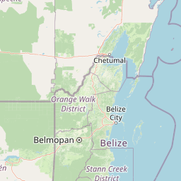
Map view of Mayflower Bocawina National Park

Use this park location map to pinpoint Mayflower Bocawina National Park in Belize, understand its exact geographic position, and read its mapped placement within the surrounding landscape more clearly.

Pigeon | © OpenStreetMap contributors

Location context for Mayflower Bocawina National Park

Stann-Creek District
Park atlas

Trace the protected landscapes of southern Belize and compare nearby tropical forests, waterfalls, and Maya heritage sites.

Explore Other National Parks and Protected Areas Near Mayflower Bocawina National Park

Explore national parks and protected areas surrounding Mayflower Bocawina National Park, revealing tropical forests, cascading waterfalls, and ancient Maya archaeological sites in southern Belize. Contrast these regional conservation landscapes, examining their unique biodiversity, mountainous terrain, and pre-Columbian heritage within the broader protected geography.
National parkCayo District
26 km away#1 closest

Southwest

Chiquibul National Park: Detailed Protected Area and National Park Geography

Explore mapped boundaries within Belize's Cayo District.

Chiquibul National Park offers a critical lens through which to view Belize's protected natural areas. As a designated national park located in the Cayo District, it provides essential data for understanding the extent and geographic positioning of conservation landscapes. Users can engage with detailed map information to trace the park's borders and appreciate its role within the national atlas of protected territories.

Area
1,073 km²
Established
1995
IUCN
II
Relief
Mountain
National parkCayo District
About 36 km away#2 closest

Northwest

St. Herman's Blue Hole National Park: National Park Protected Landscape and Geographic Setting

Mapped Boundaries and Regional Landscape Context in Cayo District

St. Herman's Blue Hole National Park is an integral protected landscape within Belize, situated in the Cayo District. This national park offers specific geographic features and mapped boundaries essential for understanding its place within regional conservation. MoriAtlas provides detailed context for exploring the park's protected terrain and its contribution to the broader geographic atlas, focusing on landscape identity and mapped outlines for analytical discovery.

Area
2 km²
Established
1986
Climate
Tropical
Access
Easy access
National parkCayo District
52 km away#3 closest

Northwest

Guanacaste National Park National Park: Explore its Protected Landscape and Geographic Setting

Mapped natural terrain and regional context within Cayo District.

Delve into the specifics of Guanacaste National Park, a protected national park located in the Cayo District of Belize. This detail page is designed for atlas exploration, offering insights into the park's geographic boundaries and its significance as a defined natural landscape. Understand how this protected area fits into the regional geography and contributes to the mapped natural heritage of Belize.

Area
0.2 km²
Established
1973
IUCN
II
Climate
Tropical
National parkToledo District
57 km away#4 closest

South

Payne's Creek National Park: National Park Protected Landscape and Geographic Atlas

Explore mapped boundaries and regional geography in Toledo District.

Payne's Creek National Park serves as a vital protected area within Belize, recognized as a national park. This entry details its specific location within the Toledo District, emphasizing the mapped extent of its protected boundaries. It provides a foundation for understanding the park's geographic character and its role within regional conservation landscapes, ideal for atlas-based discovery.

Area
152 km²
IUCN
II
Relief
Lowland
Climate
Tropical
National parkCayo District
About 69 km away#5 closest

West

Elijio Panti National Park: Protected Landscape and Regional Geography in Cayo District

Explore the mapped boundaries and geographic features of this national park.

Elijio Panti National Park offers a unique focus on protected landscape discovery within Belize. Situated in the Cayo District, this national park provides a specific geographic anchor for understanding natural terrain and mapped boundaries. The page details its identity as a protected area, contributing to a structured atlas of conservation lands and regional geography.

Area
52.645 km²
Established
2001
IUCN
II
Relief
Mountain
Biosphere reservePetén Department
78 km away#6 closest

West

Maya Biosphere Reserve: Geographic Overview and Protected Landscapes in Petén

Tropical forest ecosystems and ancient archaeological mapping

Covering roughly one-fifth of Guatemala, the Maya Biosphere Reserve represents a pioneering model of zoned conservation. The landscape features a complex mosaic of lowland rainforests, savanna patches, and seasonal wetlands formed over a weathered limestone platform. This atlas summary examines the reserve's ecological boundaries, its vital role in protecting Mesoamerican biodiversity, and the concentration of pre-Columbian cities located across the Petén Department.

Area
21,602 km²
Established
1990
Relief
Mixed relief
Climate
Tropical
Protected areaBelize
About 85 km away#7 closest

Northwest

El Pilar Archaeological Protected Area: Maya Monuments and Forested Landscapes in Belize

Binational heritage zone on the Belize and Guatemala border

El Pilar is a significant Maya archaeological site characterized by its vast collection of plazas and causeways that span the international frontier. The protected area features extensive tropical broadleaf forest that cloaks ancient stone monuments, showcasing an integrated approach to cultural heritage and ecological conservation within the Belize River valley escarpment.

Area
20 km²
Established
1998
Relief
Upland
Climate
Tropical
Biosphere reserveEl Petén
About 95 km away#8 closest

Southwest

Montañas Mayas Chiquibul Biosphere Reserve: Mapping the Maya Mountain Forest Landscapes

Exploring karst topography and protected forest corridors in El Petén

The Montañas Mayas Chiquibul biosphere reserve spans a vast, forested tract across the municipalities of San Luis and Poptún. As a cornerstone of the regional protected area network, it encompasses ridges, sinkholes, and river systems that define the transition from lowland plains to the Maya Mountain foothills. This area remains essential for understanding the natural heritage and geological complexity of northern Guatemala.

Area
1,236 km²
Relief
Highland
Water
Minor water

Common questions about visiting, size, designation, and location context for Mayflower Bocawina National Park

Mayflower Bocawina National Park FAQs for park facts, access, geography, and protected area context

Find quick answers about Mayflower Bocawina National Park, including protected-area facts, park geography, trail and visitor context, and how the park fits into its surrounding country and regional landscape.
MoriAtlas Explorer

Continue Your Protected Areas Search Across the Global Atlas

Deepen your exploration by continuing the structured search for national parks and protected areas worldwide. Utilize the comprehensive filtering capabilities to compare different conservation landscapes and refine your understanding of global park geography. Discover more about the distribution and characteristics of protected natural areas.

Global natural geography