
Mori Atlas logo
Nature reserveMbaracayú Forest Nature Reserve

Mapping the riparian corridors, forested valleys, and biodiversity within the Jejuí Guazú basin

Mbaracayú Forest Nature Reserve: An Atlas of Paraguay's Largest Atlantic Forest Protected Area

(Reserva Natural del Bosque Mbaracayú)

Mbaracayú Forest Nature Reserve represents the most significant surviving block of the Alto Paraná Atlantic forest ecosystem in eastern Paraguay. Located within the Canindeyú Department, this 64,000 hectare protected area spans a landscape of rolling terrain, deep valleys, and clear water streams. The reserve provides a critical ecological anchor for the wider region, preserving a continuous forest canopy that contrasts sharply with the surrounding agricultural land and cattle ranches.

Atlantic forestsubtropical forestprotected areanational park equivalentriparian forestwetland ecosystem
An illustrative digital artwork showing a lush green wetland, a single tree in the foreground, and pink-toned rocky mountains in the background under a soft sky.

Mbaracayú Forest Nature Reserve

Nature reserve

Park overview

Structured park overview, official facts, and landscape profile for Mbaracayú Forest Nature Reserve

Mbaracayú Forest Nature Reserve park facts, protected area profile, and essential visitor context

Review the core facts for Mbaracayú Forest Nature Reserve, including designation, size, terrain, visitor scale, habitats, and operating context in one park-focused overview.

About Mbaracayú Forest Nature Reserve

The Mbaracayú Forest Nature Reserve is one of the most significant forest protected areas in Paraguay, both for its size and for what it represents ecologically. It preserves a substantial remnant of the Alto Paraná Atlantic forests, a once-extensive ecoregion that has been largely replaced by cattle pastures, soybean fields, and smallholder farms across eastern Paraguay and neighboring parts of Brazil and Argentina. By maintaining more than 64,000 hectares of connected, high-canopy subtropical forest, Mbaracayú offers a working example of what the original regional forest landscape once looked like and what remains possible to protect at scale.

Located in the upper basin of the Jejuí Guazú River in the Canindeyú Department, the reserve occupies a transitional zone where forested ridges, deep valleys, and a network of streams converge into one of the major tributaries of the Paraná system. The northeastern corner of the reserve is shaped by the Cordillera de Mbaracayú, a low mountain range that adds altitude variation and creates the small waterfalls and microhabitats that contribute to local biodiversity. Surrounding land use is dominated by cattle ranches and family farms, which makes the protected area stand out sharply as a continuous green block in an otherwise heavily modified landscape.

Ecologically, Mbaracayú is notable for the dominance of riparian vegetation, which accounts for roughly 88 percent of its plant cover, along with patches of wetland, lagoon, cerrado, and pasture. The forest is regularly shaped by seasonal flooding tied to the regional climate, a humid subtropical regime with cold dry winters and hot wet summers. This combination of forest cover and hydrological variation supports more than 400 bird species, both of South America's large caimans, several threatened mammals, and a rich community of amphibians, ants, and butterflies.

The reserve's importance extends beyond its borders. It is the Paraguayan anchor of the proposed Trinational Biodiversity Corridor, a landscape connectivity initiative that would link protected areas in Brazil, Paraguay, and Argentina within the Upper Paraná ecoregion. Submitted to UNESCO as a proposed World Heritage Site in 2003 and managed on the ground by the Moisés Bertoni Foundation, Mbaracayú combines biodiversity protection, research, environmental education, and sustainable development into a single integrated conservation model. Its identity is rooted not just in scenery but in what it preserves of Paraguay's original forest heritage and the species that depend on it.

Quick facts and research context for Mbaracayú Forest Nature Reserve

The Mbaracayú Forest Nature Reserve covers more than 64,000 hectares of humid subtropical forest in the Canindeyú Department of eastern Paraguay, near the town of Ygatimí. It lies within the Alto Paraná Atlantic forests ecoregion and is part of the broader Upper Paraná basin, with the Jejuí Guazú River system running through it. The reserve holds IUCN Category II national park status and is managed by the Moisés Bertoni Foundation, a Paraguayan conservation organization.

Established by national law in 1991, the reserve was created through a partnership involving the Paraguayan government, UNESCO, The Nature Conservancy, and the Moisés Bertoni Foundation. It was nominated to UNESCO's World Heritage tentative list in 2003 and forms a key piece of the proposed Trinational Biodiversity Corridor linking forest reserves in Brazil, Paraguay, and Argentina. Its vegetation is dominated by riparian forest, with smaller areas of wetland, cerrado, and pasture, supporting one of the most important forest biodiversity pockets left in Paraguay.

Protection and recognition

Documented terrestrial protection scope and official recognition records

Mbaracayú Forest Nature Reserve Protection Status and Governance Data

Mbaracayú Forest Nature Reserve maintains a documented terrestrial protection scope within the regional protected area network. Official records compile available management parameters and international designation details for structured atlas research.

Protection details

Protection scope
Terrestrial
Transboundary protection
No
Park context

Deeper park guide and search-rich context for Mbaracayú Forest Nature Reserve

Mbaracayú Forest Nature Reserve history, landscape, wildlife, and travel context

Explore Mbaracayú Forest Nature Reserve through its history, landscape character, ecosystems, wildlife, conservation priorities, cultural context, and seasonal travel timing in a structured park guide built for atlas discovery and search intent.

Why Mbaracayú Forest Nature Reserve stands out

Mbaracayú is best known as the largest surviving block of Alto Paraná Atlantic forest in Paraguay, a humid subtropical ecoregion that has been heavily reduced elsewhere by agriculture and ranching. The reserve's continuous canopy, riparian forest systems, and waterfalls make it a defining example of Upper Paraná forest ecology still under formal protection. The reserve also stands out for its unusually rich fauna within a relatively compact protected footprint. With more than 400 bird species and significant populations of jaguar, tapir, maned wolf, bush dog, giant armadillo, and both major South American caiman species, the reserve is a leading site for Atlantic forest biodiversity conservation in the country. Its role within the proposed Trinational Biodiversity Corridor gives it additional importance as a connector for landscape-scale conservation in South America.
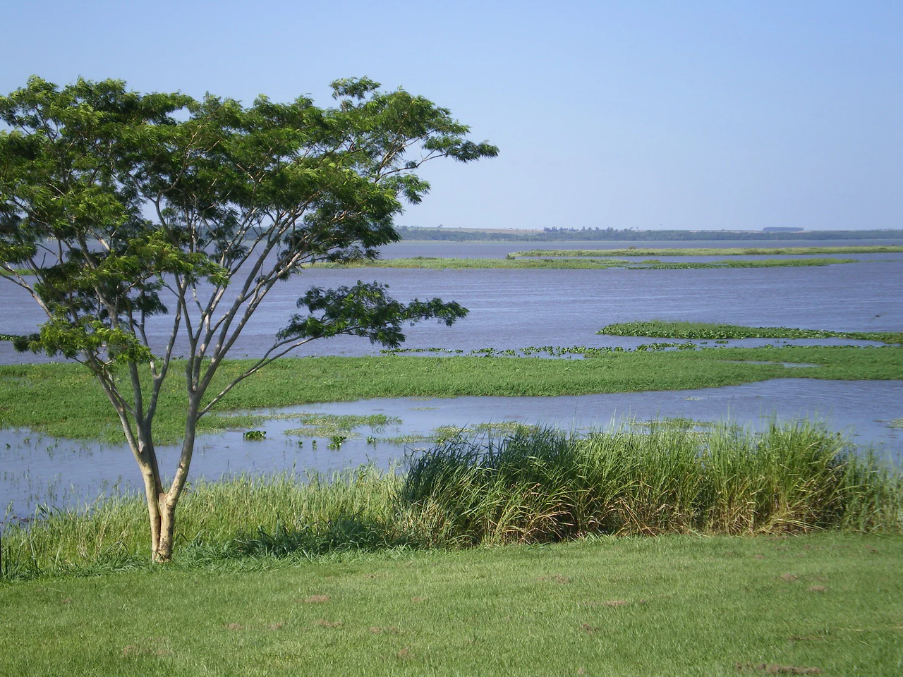
A wide view of a calm wetland landscape with a lone green tree in the foreground and patches of aquatic vegetation in the water under a clear blue sky.
A view of the wetlands and lush greenery within the Mbaracayu Forest Nature Reserve.

Mbaracayú Forest Nature Reserve history and protected-area timeline

The Mbaracayú Forest Nature Reserve was created through a formal agreement among the government of Paraguay, the Moisés Bertoni Foundation, UNESCO, and The Nature Conservancy. This agreement was ratified in 1991 by Paraguayan National Law 112/91, which designated the area as a Paraguayan heritage zone dedicated in perpetuity to the protection of forest ecosystems, biological diversity, and cultural resources, alongside the promotion of sustainable economic development.

Following its designation, the reserve gained increasing recognition as a conservation priority at the regional level. In December 2003, it was formally submitted to UNESCO as a proposed World Heritage Site, reflecting its perceived importance within the broader Alto Paraná Atlantic forests ecoregion. The reserve also became a cornerstone of the proposed Trinational Biodiversity Corridor, an initiative aimed at linking forest reserves across Brazil, Paraguay, and Argentina in the Upper Paraná basin.

Throughout its history, the reserve has been shaped by the involvement of the Moisés Bertoni Foundation, which has served as both administrator and steward. The foundation's role has extended beyond enforcement to include environmental education, scientific research, and the development of sustainable economic models for the surrounding communities, particularly in a region where cattle ranching and small-scale agriculture dominate land use.

Mbaracayú Forest Nature Reserve landscape and geographic character

The physical setting of the Mbaracayú Forest Nature Reserve is defined by the upper Jejuí Guazú River basin, a region of rolling terrain, forested valleys, and clear-water streams that feed into one of the major tributaries of the Paraná River system. The northeastern corner of the reserve rises into the Cordillera de Mbaracayú, a low mountain range that adds relief to an otherwise predominantly forested landscape. This range produces the small, deep valleys and waterfalls that punctuate the reserve's interior.

Much of the reserve's surface consists of riparian forest, where vegetation is closely tied to river channels and seasonal flooding patterns. The land is shaped by periodic flooding tied to the regional humid subtropical climate, creating a mosaic of forest, wetland, and open water. Among the forested areas, cerrado patches and small lagoons add additional variety to the terrain, though riparian vegetation clearly dominates the overall landscape.

The contrast with surrounding land use is one of the reserve's most distinctive visual qualities. Cattle ranches and small farms occupy most of the adjacent non-protected land, making the reserve appear as a continuous green block where the original Atlantic forest character still dominates. Within the reserve, the combination of mountain ridges, valley streams, and dense canopy gives the terrain a layered quality, with broken topography, waterfalls, and shaded corridors providing a strong sense of interior wilderness.

Mbaracayú Forest Nature Reserve ecosystems, habitats, and plant life

Ecologically, the Mbaracayú Forest Nature Reserve is a stronghold of the Alto Paraná Atlantic forests ecoregion, a humid subtropical forest system that historically stretched across large portions of eastern Paraguay, southern Brazil, and northeastern Argentina. Roughly 88 percent of the reserve's vegetation is classified as riparian forest, while the remainder includes wetland, pasture fragments, lagoon environments, and patches of cerrado savanna vegetation.

The reserve's flora reflects the economic and ecological importance of Atlantic forest trees. Commercially and culturally significant species include yerba mate, tree ferns such as Alsophila atrovirens, and valuable hardwoods like Aspidosperma polyneuron, Cedrela fissilis, Balfourodendron riedelianum, and Peltophorum dubium. Flowering species such as Tabebuia add seasonal color, and the canopy as a whole plays a critical role in stabilizing soils, regulating local hydrology, and maintaining habitat conditions throughout the Jejuí Guazú basin.

Seasonal flooding is a defining ecological process in the reserve, shaping both forest composition and species distribution. The humid subtropical climate, with cold dry winters and hot wet summers, drives cycles of saturation and drying that influence plant communities, aquatic habitats, and the breeding cycles of many animal species. Together, the dominance of riparian vegetation, the cerrado patches, the wetlands, and the lagoons create a heterogeneous ecological mosaic that supports both forest-specialist and edge-species communities.

Mbaracayú Forest Nature Reserve wildlife and species highlights

Mbaracayú supports one of the richest faunas of any protected area in Paraguay, with wildlife that reflects the broader biodiversity of the Alto Paraná Atlantic forests. Large mammals still roam the reserve, including jaguar, South American tapir, maned wolf, bush dog, neotropical otter, and giant armadillo. Many of these species are threatened or endangered at the regional level, making the reserve an important refuge for populations that have disappeared from much of the surrounding landscape.

The wetlands and waterways host both of South America's significant caiman species, the yacaré caiman and the broad-snouted caiman, along with diverse amphibian communities. Roughly 20 species of amphibians are documented, and the reserve's moist forest environment supports a substantial community of invertebrates, including at least 219 species of ants and a notable diversity of butterflies that reflect the complexity of the understory and canopy habitats.

The reserve is perhaps best known for its birdlife, with more than 400 recorded species. Among the most distinctive are red-and-green macaw, king vulture, black-fronted piping guan, helmeted woodpecker, and bare-throated bellbird. This combination of frugivores, raptors, and forest interior species underlines the reserve's value as habitat for birds that depend on large, undisturbed tracts of Atlantic forest for nesting and foraging.

Mbaracayú Forest Nature Reserve conservation status and protection priorities

The Mbaracayú Forest Nature Reserve holds IUCN Category II national park status, the highest protection category recognized internationally, and was ratified by Paraguayan national law in 1991. Its conservation significance lies in its role as the largest continuous block of Alto Paraná Atlantic forest still protected in Paraguay, in a region where native forest cover has been heavily reduced by agriculture and livestock production.

The reserve anchors the Paraguayan portion of the proposed Trinational Biodiversity Corridor, a regional initiative designed to maintain forest connectivity between protected areas in Brazil, Paraguay, and Argentina within the Upper Paraná ecoregion. This positions Mbaracayú not just as an isolated reserve but as a critical node in a broader, transboundary effort to maintain long-term ecological functionality across one of South America's most threatened forest systems.

In 2003, the reserve was submitted to UNESCO as a proposed World Heritage Site, reflecting international recognition of its biological, ecological, and cultural value. On-the-ground management by the Moisés Bertoni Foundation integrates strict habitat protection with environmental education, scientific research, and sustainable development programs aimed at reducing pressures from the surrounding ranching and farming communities.

Mbaracayú Forest Nature Reserve cultural meaning and human context

The creation of the reserve reflects a strong national identity tied to Paraguay's remaining forest heritage and to indigenous and rural cultural connections with the Alto Paraná Atlantic forests. The 1991 founding law specifically committed the area to the protection of cultural resources alongside biodiversity, recognizing that the forest landscape carries deep historical and traditional significance.

The Moisés Bertoni Foundation, which administers the reserve, is named after Moisés Santiago Bertoni, a notable scientist who lived and worked in Paraguay, reflecting the country's tradition of linking scientific study with natural heritage conservation. In the surrounding region, where small farms and cattle ranches dominate, the reserve also represents a cultural counterpoint: a place where the native forest landscape, rivers, and traditional uses of forest products such as yerba mate continue to play a role in regional identity and rural livelihoods.

Top sights and standout views in Mbaracayú Forest Nature Reserve

The Mbaracayú Forest Nature Reserve combines exceptional biodiversity, large-scale forest protection, and transboundary conservation ambition in a single protected area. Its size, ecological continuity, and position within the Alto Paraná Atlantic forests make it the most important surviving forest block of its kind in Paraguay. Among its standout features are the dominance of riparian forest, the waterfalls and valleys of the Cordillera de Mbaracayú, and the seasonal flooding dynamics that shape both landscape and wildlife.

Best time to visit Mbaracayú Forest Nature Reserve

The reserve's humid subtropical climate produces two clearly defined seasons that influence both scenery and wildlife viewing. The wet summer months bring higher temperatures, lush forest growth, expanded wetlands, and active caiman and amphibian presence, but also more humid conditions and heavier rains. The dry winter months are cooler, with occasional cold spells, and tend to offer easier access along trails and more comfortable conditions for birdwatching and forest hiking. Both seasons can be rewarding: the wet season emphasizes the reserve's lush, flooded character and rich reptile and amphibian activity, while the dry season offers clearer weather and a different set of bird and mammal viewing opportunities.
Monthly climate preview

Long-term temperature and precipitation patterns across representative coordinates

Mbaracayú Forest Nature Reserve Climate Normals and Annual Weather Rhythm

Recorded monthly climate data for Mbaracayú Forest Nature Reserve shows sustained warmth alongside distinct annual variations in temperature and precipitation. Examining the complete twelve-month record provides deeper insight into long-term meteorological averages across the protected area.
Annual mean23 °C
18 °C27 °C
Jan27°
Feb27°
Mar26°
Apr23°
May19°
Jun18°
Jul18°
Aug20°
Sep22°
Oct24°
Nov25°
Dec26°
Warmest month
January

27.1 °C

Coolest month
July

17.5 °C

Wettest month
November

6.2 mm/day

Driest month
July

1.8 mm/day

Park location guide

Geography guide, regional context, and park location map for Mbaracayú Forest Nature Reserve

Mbaracayú Forest Nature Reserve park geography, regions, and map view in Paraguay

Understand where Mbaracayú Forest Nature Reserve sits in Paraguay through a broader geographic reading of the surrounding landscape, nearby location context, and its mapped position within the national park landscape.

How Mbaracayú Forest Nature Reserve fits into Paraguay

Paraguay is a landlocked presidential republic in central South America with a population of approximately 6.4 million. Originally inhabited by the Guaraní people, it was colonized by Spain in the 16th century and gained independence in 1811. The country is notable for its strong Guarani cultural influence, economic growth driven by soybean and beef exports, and significant hydroelectric power generation. Asunción is both the capital and largest city.

Wider geography shaping Mbaracayú Forest Nature Reserve in Paraguay

Paraguay is located in the central region of South America, completely landlocked but with Atlantic Ocean access via the Paraná-Paraguay Waterway. It borders Bolivia to the northwest and north, Brazil to the northeast and east, and Argentina to the southeast, south, and west. The terrain consists mostly of rolling plains and lowlands, with the Paraguay River dividing the country into eastern and western regions.

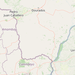
Map view of Mbaracayú Forest Nature Reserve

Use this park location map to pinpoint Mbaracayú Forest Nature Reserve in Paraguay, understand its exact geographic position, and read its mapped placement within the surrounding landscape more clearly.

Pigeon | © OpenStreetMap contributors

Location context for Mbaracayú Forest Nature Reserve

Canindeyú Department

Visual exploration of Alto Paraná Atlantic forest terrain and protected habitats

Mbaracayú Forest Nature Reserve Photos and Landscape Scenery

Photographic records capture the dense canopy, river valleys, and waterfalls defining the Mbaracayú Forest Nature Reserve environment. Visual documentation reveals the distinct protected area character and forested terrain preserved within eastern Paraguay.

A wide view of a calm wetland landscape with a lone green tree in the foreground and patches of aquatic vegetation in the water under a clear blue sky.

Park atlas

Compare regional park geography and adjacent Atlantic forest reserves

Parks Near Mbaracayú Forest Nature Reserve and Related Protected Landscapes

Browsing other protected areas near Mbaracayú Forest Nature Reserve reveals broader regional conservation networks across eastern Paraguay. Extending geographic comparison helps visitors evaluate connected forest ecosystems and surrounding natural terrain.
A soft watercolor illustration depicting a serene landscape with rolling green hills, scattered trees, and a winding stream under a warm, light-colored sky.
Wildlife reserveCanindeyú Department
About 109 km away#1 closest

East

Refugio Carapá Wildlife Reserve: Mapping Biological Diversity in Canindeyú Department

A protected sub-tropical mosaic along the Paraná River basin

Refugio Carapá protects a dramatic stretch of mountain slopes and riverine valleys in the Department of Canindeyú. By managing a mosaic of tall forests, swamps, and open camp vegetation, the reserve maintains a crucial ecological link within the wider Itaipu reservoir landscape. The area functions as a research-focused environment dedicated to preserving native flora and threatened species in eastern Paraguay.

Area
32.5 km²
Established
1984
Relief
Mountain
Climate
Subtropical
Wildlife reserveAlto Paraná Department
About 161 km away#2 closest

Southeast

Tatí Yupí Refuge: Wildlife Reserve Geography and Paraná River Landscape

A 2,245 hectare protected biological forest in Alto Paraná

Tatí Yupí Refuge offers a unique perspective on protected land management within the Itaipu hydroelectric complex. Explore the mapped boundaries, basaltic stream formations, and subtropical forest habitat that define this essential ecological refuge in Paraguay's Alto Paraná Department.

Area
22.45 km²
Established
1982
Relief
Lowland
Climate
Subtropical
National parkParaguay
About 180 km away#3 closest

Northwest

Cerro Corá National Park: Paraguay's Protected Landscape and Regional Geography

Discover the mapped boundaries and natural context of this national park.

Cerro Corá National Park serves as a critical element in Paraguay's protected natural areas. This page offers a deep dive into its identity as a national park, focusing on its geographic location, mapped boundaries, and its place within the broader landscape context of South America. Understand the specific atlas value of this protected land for detailed geographic exploration.

IUCN
II
Natural monumentAlto Paraná Department
About 191 km away#4 closest

Southeast

Moisés Bertoni Scientific Monument: Protected Atlantic Forest in Alto Paraná, Paraguay

Natural monument and historic research landscape

Explore the geographic footprint of Moisés Bertoni Scientific Monument, an essential protected area in the Alto Paraná Department. This site safeguards mature Atlantic Forest ecosystems along the Paraná River while preserving the historic research station and cultural legacy of its founder. The monument remains a pivotal landmark for understanding the biodiversity and conservation landscape of eastern Paraguay.

Area
1.99 km²
Established
1955
Relief
Lowland
Climate
Subtropical
National parkMisiones Province
About 196 km away#5 closest

Southeast

Iguazú National Park: Argentina's Misiones Province Protected Landscape Atlas

Explore mapped boundaries and regional geography.

Iguazú National Park serves as a key protected natural area situated within Misiones Province. This MoriAtlas entry details its mapped geographic boundaries, contributing essential context for understanding its landscape identity. Users can explore how this national park fits into the regional geography, providing a factual basis for detailed atlas-based study of protected lands and their unique terrain.

Area
677 km²
Established
1934
IUCN
II
Relief
Lowland
State or regional parkMisiones Province
About 218 km away#6 closest

Southeast

Urugua-í Provincial Park: Exploring the Atlantic Forest Landscapes of Misiones Province

A regional atlas of protected watersheds and forest corridors

Spanning from the rolling lowlands of the Urugua-í River to the rugged slopes of the Sierra de la Victoria, this protected area represents one of the most significant forest blocks in the region. Examine the mapped drainage patterns, watershed connectivity, and forest mosaic that define this essential Argentine conservation landscape.

Area
840 km²
Established
1990
IUCN
II
Relief
Upland
National parkParaguay
About 226 km away#7 closest

South

Ñacunday National Park National Park: Paraguay's Protected Landscape and Mapped Boundaries

Explore its unique geography and protected terrain.

Gain a precise understanding of Ñacunday National Park, a designated national park in Paraguay. This entry focuses on its role as a protected landscape, detailing its geographic attributes and mapped boundaries. It serves as a vital resource for users seeking specific information on the park's natural terrain and its contribution to Paraguay's conservation geography, facilitating structured discovery within the atlas.

Area
20 km²
Established
1993
Relief
Mixed relief
Climate
Subtropical
National parkItapúa Department
About 260 km away#8 closest

South

San Rafael National Park: National Park Protected Landscape & Geographic Overview

Discover the mapped boundaries and regional setting in Itapúa.

San Rafael National Park is a significant protected area designated as a national park in Paraguay's Itapúa Department. This page serves as an atlas-centric entry point, offering a detailed view of its geographic scope, mapped park boundaries, and its role as a conservation landscape. Users can explore the park's terrain and its place within the regional geography for a structured understanding of its protected status.

Area
693.04 km²
Established
1992
IUCN
II
Relief
Upland

Common questions about visiting, size, designation, and location context for Mbaracayú Forest Nature Reserve

Mbaracayú Forest Nature Reserve FAQs for park facts, access, geography, and protected area context

Find quick answers about Mbaracayú Forest Nature Reserve, including protected-area facts, park geography, trail and visitor context, and how the park fits into its surrounding country and regional landscape.
MoriAtlas Explorer

Continue Your Protected Areas Search Across the Global Atlas

Deepen your exploration by continuing the structured search for national parks and protected areas worldwide. Utilize the comprehensive filtering capabilities to compare different conservation landscapes and refine your understanding of global park geography. Discover more about the distribution and characteristics of protected natural areas.

Global natural geography