Mori Atlas logo
National parkМещёра

Explore the complex mosaic of lowland forests, raised bogs, and meandering river systems.

Мещёра National Park: An Atlas of Protected Landscapes and Glacial Terrain in Vladimir Oblast

(National Park "Meshchera")

Мещёра National Park preserves a vast, intact lowland landscape shaped by ancient glacial processes on the Meshchera Plain. This protected area in the Vladimir Oblast serves as a critical junction between boreal taiga and broadleaf forest biomes. The terrain features extensive pine and birch woodlands rooted in sandy soils, interconnected by slow meandering rivers and glacial lakes that define the regional hydrology.

lowland forestmixed coniferous and broadleaf forestpeat bogswetlandsglacial lakesmeandering rivers

Мещёра

National park

Park overview

Structured park overview, official facts, and landscape profile for Meshchera National Park

Meshchera National Park park facts, protected area profile, and essential visitor context

Review the core facts for Meshchera National Park, including designation, size, terrain, visitor scale, habitats, and operating context in one park-focused overview.

About Meshchera National Park

Meshchera National Park is a federal protected area in western Russia that preserves the largest contiguous block of natural landscapes on the Meshchera Plain within Vladimir Oblast and, since 2016, also in neighboring Ryazan Oblast. The park was created in 1992 to safeguard the natural complexes of this lowland region, and its boundaries were significantly enlarged when the former Meshchersky National Park in Ryazan Oblast was merged into it.

The protected territory sits on a flat, sandy lowland shaped by ancient glaciation. Morainic and fluvioglacial plains, outwash plains, and patches of aeolian dune sands combine to form a landscape of subtle relief, drained by slow rivers and dotted with small lakes and bogs. The dominant vegetation is mixed coniferous and broadleaf forest, with extensive pine-dominated woodlands and secondary birch stands growing on podzol and waterlogged soils. Approximately 70 percent of the park is forested, and large peatlands occupy thousands of hectares.

The park lies within the broader Meshchera Plain, a region long associated with traditional forest uses including hunting, fur trapping, fishing, and beekeeping. Today, it functions as a conservation anchor for the central Russian forest lowland, protecting representative habitats at the transition between taiga and broadleaf forest zones. Its proximity to Gus-Khrustalny gives it a clear regional role as a natural reference site for Vladimir Oblast and the wider Meshchera region.

Quick facts and research context for Meshchera National Park

Meshchera National Park was established on April 9, 1992, and is administered as a federal state institution. It occupies roughly 2,239 square kilometers across Vladimir Oblast, with a 2016 expansion that incorporated the Meshchersky National Park in Ryazan Oblast to the south. The park lies on the Meshchera Plain, a low-lying sandy terrain within the Moscow Sineclise, with elevation ranges across the protected area typically within about 110 to 150 meters above sea level.

The park belongs to the mixed coniferous and broadleaf forest zone and is dominated by pine and birch woodlands growing on podzol and bog soils. About 70 percent of the territory is forested, and extensive peatlands, lakes, and river valleys shape much of its remaining surface. Administratively, the nearest major town is Gus-Khrustalny, a city historically associated with the region's glassmaking and forest-based industry.

Protection and recognition

Review official terrestrial protection metrics and recognized status for Мещёра

Мещёра Protection Status and Documented Conservation Scope

Documented records for Мещёра outline its terrestrial protection status and management scope within the protected area network. Official data compiles available designation history and recognized framework details for regional analysis.

Protection details

Protection scope
Terrestrial
Transboundary protection
No
Park context

Deeper park guide and search-rich context for Meshchera National Park

Meshchera National Park history, landscape, wildlife, and travel context

Explore Meshchera National Park through its history, landscape character, ecosystems, wildlife, conservation priorities, cultural context, and seasonal travel timing in a structured park guide built for atlas discovery and search intent.

Why Meshchera National Park stands out

Meshchera National Park is best known for protecting a large, intact block of the Meshchera Plain, a lowland region characterized by flat glacial terrain, sandy pine forests, raised bogs, meandering rivers, and glacial lakes. The park is recognized as a stronghold for the mixed coniferous and broadleaf forest landscape that defines the transition between southern taiga and nemoral broadleaf forest in central European Russia. The area also stands out for its well-preserved forest and bog mosaic, which supports a wide range of forest mammals, wetland birds, and ancient aquatic species including the Russian desman. Old-growth pine and birch stands, large Sphagnum bogs, cranberry and blueberry forest types, and lakes such as Lake Svyatoye on the western edge of the park give the territory a distinctive character that sets it apart from the surrounding agricultural lowlands.
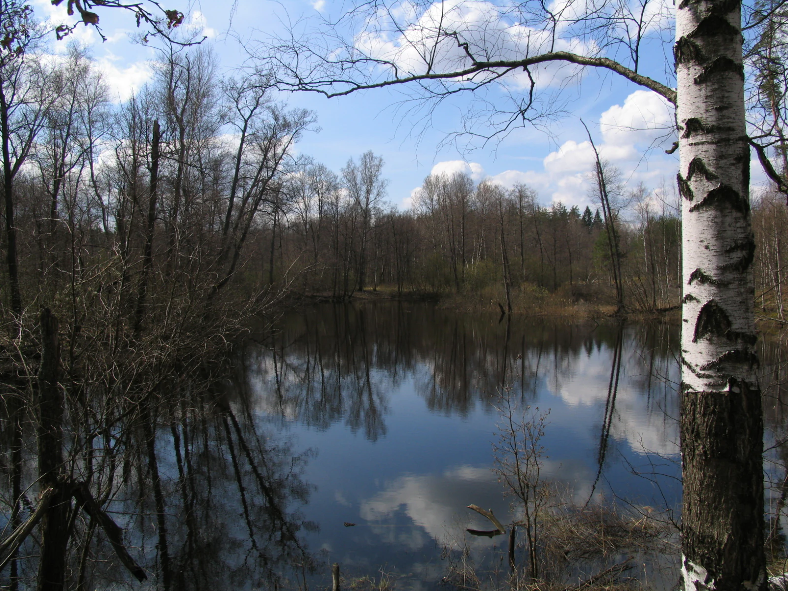
Meshchera Lowlands Landscape
View of the Meshchera Lowlands in the Vladimir Oblast, Russia.

Meshchera National Park history and protected-area timeline

The national park was officially established on April 9, 1992, as a federal protected area of Russia, with the primary mission of preserving the natural complexes of the Meshchera Plain within Vladimir Oblast. At the time of its creation, the park encompassed lands largely divided between the park's own management and surrounding хозяйствennye uses, reflecting the long-standing tradition of forest-based livelihoods in the region.

In 2016, Meshchera National Park was significantly expanded when the neighboring Meshchersky National Park in Ryazan Oblast was officially merged into it. This consolidation brought additional southern portions of the Meshchera lowland, including extensive forests and bogs, into a single protected administrative unit, strengthening the park's role as the main federal reserve for the Meshchera Plain. Throughout its history, the Meshchera region has been associated with hunting, fur trapping, fishing, and traditional beekeeping, practices that predate the formal park by centuries and that continue to shape the relationship between local communities and the forested lowland landscape.

Meshchera National Park landscape and geographic character

The landscape of Meshchera National Park is defined by the flat, sandy lowland of the Meshchera Plain, part of the southern Moscow Sineclise, a structural depression of the ancient Russian Platform. The terrain is shaped mainly by glacial and post-glacial processes, producing morainic and fluvioglacial plains, outwash plains, and small areas of aeolian dune sands. Elevations across the park vary only modestly, with a total relief amplitude of about 36 meters across the entire protected area.

Drainage is slow and diffuse. The park lies entirely within the Oka River basin, with the principal rivers being the Buzha, which runs for roughly 80 kilometers through the park, and its tributary the Pol. Both rivers meander strongly through weakly incised valleys, often flanked by boggy and peaty banks. Numerous small lakes of glacial origin, as well as former river channels now forming oxbow lakes, add to the wetland character. The most prominent lake within the park is Lake Svyatoye, the northernmost of the Klepikovskiye Lakes system, part of which lies within park boundaries.

The soils reflect the sandy substrate and poor drainage: sod-podzolic soils dominate the drier forest sites, while peat and bog soils cover extensive flat and waterlogged areas. Together, the forests, bogs, lakes, and slow rivers create the characteristic Meshchera mosaic of pine woodland interspersed with wetland openings, a landscape of subdued relief but rich ecological diversity.
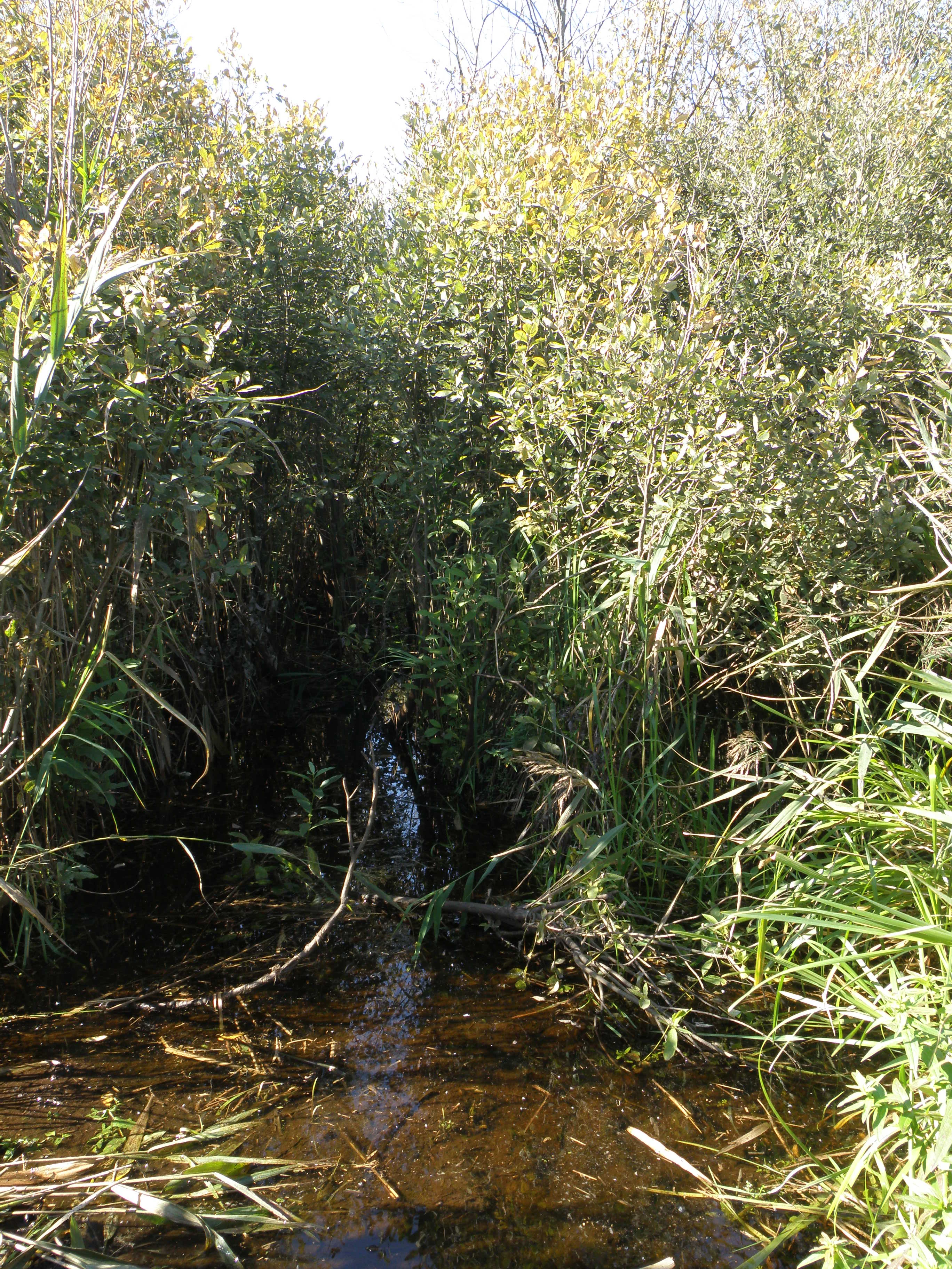
The Pol River anabranch
Anabranch in the floodplain of the Pol River

Meshchera National Park ecosystems, habitats, and plant life

The park falls within the mixed coniferous and broadleaf forest zone, sitting at the ecological meeting point of the northern Eurasian taiga region and the East European broadleaf forest region. Because of this transitional location, the vegetation of Meshchera combines features of southern taiga, mixed coniferous and broadleaf forests, and true broadleaf forest, giving the area unusually high floristic diversity for a lowland region.

Forests cover approximately 70 percent of the park. Pine-dominated woodlands are by far the most common forest type, occupying a wide range of habitats from dry lichen-rich "white moss" pine stands to wet Sphagnum pine bogs with Labrador tea. Birch forests, mostly secondary, are widespread and together with pine make up most of the wooded area. Spruce is scarce, aspen patches are small, and alder carr occurs in river valleys and depressions. True broadleaf forests, mainly pedunculate oak, are limited to small areas in river valleys, while mixed coniferous and broadleaf stands, considered the zonal vegetation climax, are scattered across the terrain.

The understory and ground layer reflect both forest and bog environments. Bilberry and lingonberry forest types are widespread, raspberry thickets and wild strawberry carpets appear in drier, lighter openings, and large cranberry bogs cover extensive flat areas. Peat bogs alone occupy several thousand hectares, making the Meshchera wetlands a defining element of the park's ecological identity.
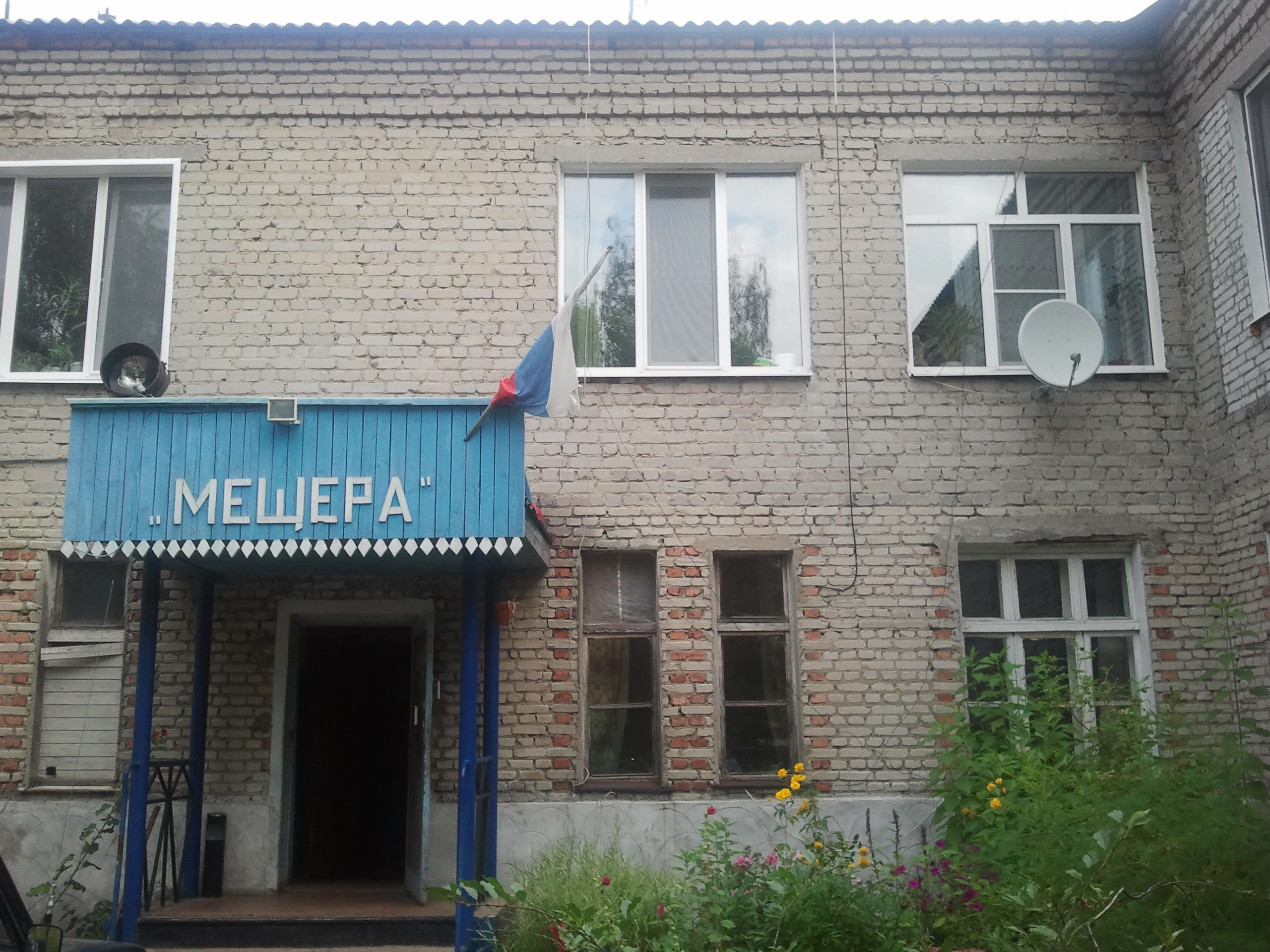
Meshchera National Park Administration in Mezinovsky
The administrative office of Meshchera National Park located in the settlement of Mezinovsky.

Meshchera National Park wildlife and species highlights

The fauna of Meshchera is typical of central European Russia, with mostly European-origin species and only a subordinate representation of true taiga forms. The park's main contribution to wildlife conservation lies not in unique species but in its very large, contiguous forest and bog complex, which supports animal populations needing extensive home ranges.

Among mammals, the most numerous species include the mountain hare, red squirrel, and red fox. Moose, wild boar, Eurasian beaver, raccoon dog, American mink, least weasel, stoat, wolf, pine marten, and European badger are common, while European hare, European polecat, and Eurasian otter occur more sparsely. Brown bears occasionally wander into the park, and the Russian desman, an endemic aquatic mammal of the East European fauna, inhabits some of the river and lake habitats.

The birdlife is rich, with 186 recorded species. Typical forest and wetland species such as the common crane, western capercaillie, black grouse, and hazel grouse are present alongside birds of prey and wetland birds including the white stork, grey heron, Eurasian bittern, and common snipe. Several rare birds important for conservation, including the golden eagle, greater spotted eagle, short-toed snake eagle, white-tailed eagle, lesser white-fronted goose, peregrine falcon, osprey, Eurasian eagle-owl, and black stork, are recorded within the park.

Reptiles include six species, among them the smooth snake, common European adder, grass snake, slow worm, viviparous lizard, and sand lizard, while amphibians include the fire-bellied toad, garlic toad, common and green toads, several frog species, and both crested and smooth newts. Fish fauna is dominated by common species such as roach, perch, pike, crucian carp, and the introduced Amur sleeper, with rarer native species like the blue bream and white-eye bream still present in some waters.
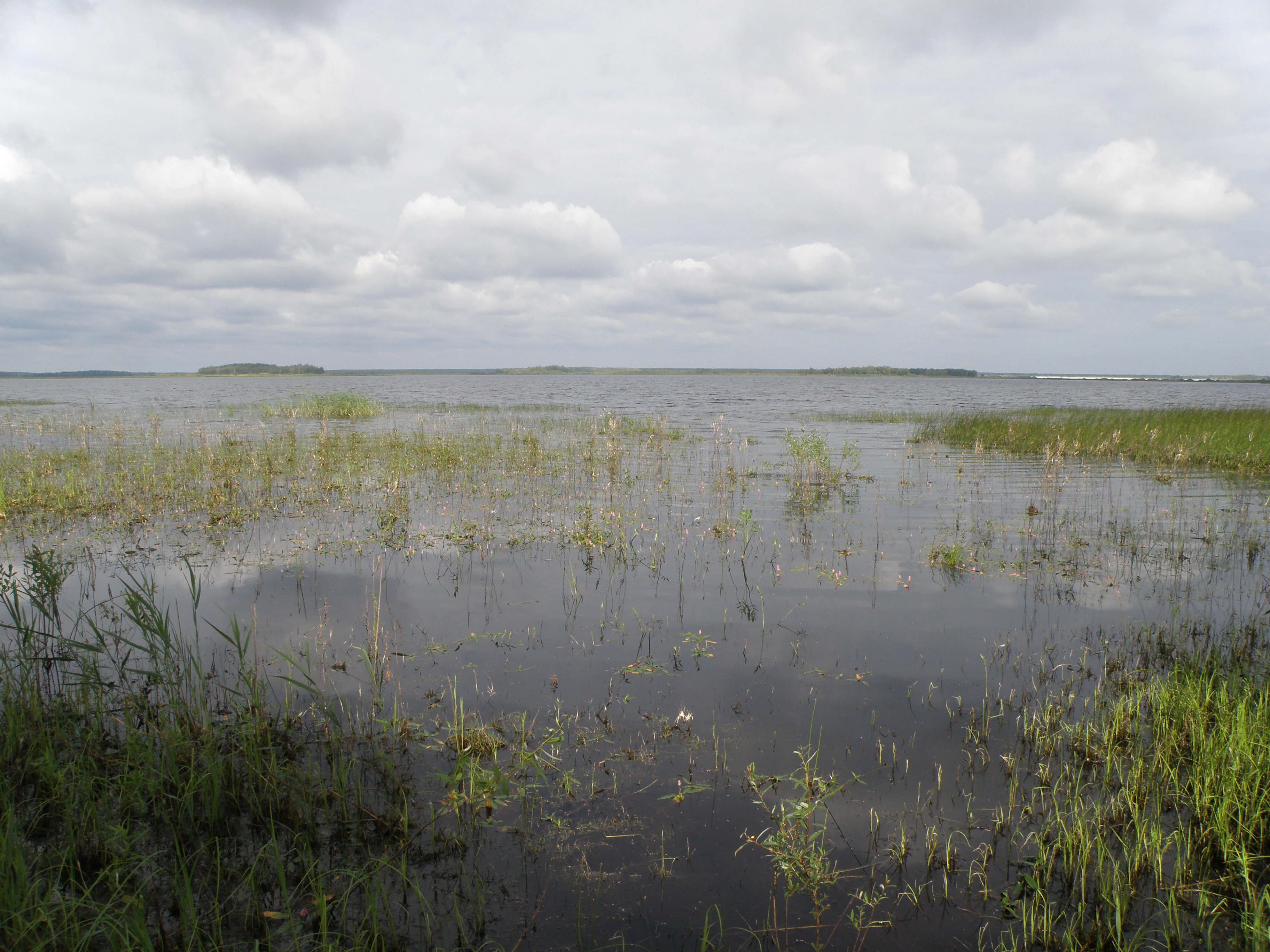
Svyatoe Lake
View of Svyatoe Lake in summer 2012 from the eastern shore

Meshchera National Park conservation status and protection priorities

Meshchera National Park plays a key role in conserving the forest and wetland landscapes of the Meshchera Plain, a lowland region that is otherwise heavily affected by forestry, drainage, and agriculture. By protecting a large, contiguous block of mixed coniferous and broadleaf forest together with extensive bogs, lakes, and river valleys, the park secures habitat for species that depend on large, unbroken forest and wetland complexes, including large mammals and area-sensitive birds.

The park is particularly important for the conservation of wetland-related species and processes. Its peatlands, slow meandering rivers, and glacial lakes support rare, range-restricted, and protected species such as the Russian desman, a regional endemic aquatic mammal, as well as a notable suite of rare birds. Several plant, bird, and mammal species recorded within the park are listed in the Red Data Book of the Russian Federation, reflecting the conservation value of the area.

Beyond its direct habitat protection, the park functions as a reference site for understanding the natural state of the Meshchera Plain and for monitoring long-term changes in forest composition, bog development, and hydrology in the region. Its status as a federal national park, combined with its 2016 expansion through the merger of Meshchersky National Park, enhances its role as the principal conservation anchor for the Meshchera lowland landscape.

Meshchera National Park cultural meaning and human context

The Meshchera lowland has a long history of traditional forest-based land use, shaped by the abundance of game, fish, forested terrain, and wetland resources. Hunting, furbearer trapping, wildfowl hunting, fishing, and beekeeping were the defining traditional livelihoods of local communities, and historical documents such as the land grants of Ryazan princes to local monasteries refer to the area's rich wildlife.

The park's administrative center is located in the settlement of Mezinovsky, and its nearest major city is Gus-Khrustalny, a town long associated with the region's forest-based economy and its historic crystal and glass industry. The surrounding cultural landscape reflects a deep entanglement between people and forest, a relationship now expressed through the park's conservation role rather than through commercial extraction, while small settlements, forestry traditions, and local knowledge of the wetlands remain part of the broader Meshchera cultural setting.

Top sights and standout views in Meshchera National Park

Meshchera National Park is distinguished by the sheer scale and intactness of its lowland forest and bog landscape, which preserves a classic example of the Meshchera Plain at the meeting point of taiga and broadleaf forest biomes. Its extensive pine-dominated woodlands on sandy soils, broad peat bogs with cranberries, lakes, and slow meandering rivers form a coherent ecological mosaic rarely matched elsewhere in central Russia.

Lake Svyatoye on the western edge of the park, the Buzha and Pol rivers, and the surrounding peatlands are among the most distinctive features of the territory. The park's importance for area-sensitive wildlife, including rare birds of prey listed in the Russian Red Data Book and the endemic Russian desman, gives it a conservation profile that extends well beyond its regional setting.

Best time to visit Meshchera National Park

The park experiences a temperate continental climate with clearly defined seasons, snowy winters and warm summers. Spring brings the gradual thaw of snow cover, rising river levels, and the rapid greening of forests and bogs, while summer offers the warmest conditions and the most active wildlife, including breeding birds and rich insect life across bogs and meadows.

Autumn typically features cooling temperatures, cranberry and berry ripening in bogs and forests, and quieter conditions. Winter brings sustained snow cover for several months, freezing of lakes and rivers, and a calm, deeply seasonal atmosphere. Each season highlights a different aspect of the Meshchera landscape, from active wetland life in summer to the stark, snow-covered forest and frozen lakes in winter.
Monthly climate preview

Long-term representative point measurements for Vladimir Oblast terrain

Мещёра Climate Normals, Annual Temperature and Precipitation Rhythms

Historical records from 1991 to 2020 outline the measured annual temperature and precipitation rhythm across representative coordinates in Мещёра. Detailed monthly breakdowns provide deeper comparative context on long-term thermal averages and precipitation patterns.
Annual mean4 °C
-11 °C19 °C
Jan-11°
Feb-10°
Mar-4°
Apr
May13°
Jun17°
Jul19°
Aug18°
Sep12°
Oct
Nov-3°
Dec-9°
Warmest month
July

19.4 °C

Coolest month
January

-11 °C

Wettest month
June

2.7 mm/day

Driest month
March

1.3 mm/day

Park location guide

Geography guide, regional context, and park location map for Meshchera National Park

Meshchera National Park park geography, regions, and map view in Russia

Understand where Meshchera National Park sits in Russia through a broader geographic reading of the surrounding landscape, nearby location context, and its mapped position within the national park landscape.

How Meshchera National Park fits into Russia

Russia is a transcontinental nation spanning eleven time zones, bordered by fourteen countries. It is the world's largest country by area, covering 17,098,246 km². Moscow is the capital and largest city, while Saint Petersburg is the second-largest and a major cultural centre.

Wider geography shaping Meshchera National Park in Russia

Russia spans Eastern Europe and North Asia, covering 17,098,246 km². It shares land borders with fourteen countries, more than any other nation, and spans eleven time zones. The landscape includes vast plains, mountain ranges such as the Urals and Caucasus, and extensive coastlines along the Arctic Ocean, Pacific Ocean, Baltic Sea, Black Sea, and Caspian Sea.

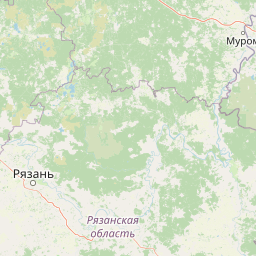
Map view of Meshchera National Park

Use this park location map to pinpoint Meshchera National Park in Russia, understand its exact geographic position, and read its mapped placement within the surrounding landscape more clearly.

Pigeon | © OpenStreetMap contributors

Location context for Meshchera National Park

Vladimir Oblast

Explore real imagery of the pine woodlands, glacial lakes, and meandering rivers that define Мещёра.

Мещёра Photos and Protected Area Scenery: Visualizing Lowland Forests and Bogs

Visual documentation of Мещёра reveals the subtle topography, sandy pine forests, and extensive peat bogs of the protected lowland plain. Examining these landscape views and habitat features helps researchers understand the ecological character of central Russia's taiga transition zone.

Meshchera Lowlands Landscape

Buzha River at Tikhonovo

The Pol River anabranch

Meshchera National Park Administration in Mezinovsky

Svyatoe Lake

Park atlas

Compare adjacent lowland forests, glacial lakes, and boreal transition zones.

Other Parks Near Мещёра and Protected Areas in the Surrounding Region

Continue exploring protected landscapes beyond Мещёра by examining adjacent lowland reserves and wetland ecosystems. Comparing these regional conservation areas provides deeper context on the shared geography of the East European plain.
Watercolor painting of a lake surrounded by trees and distant hills
National parkVladimir Oblast
About 0.7 km away#1 closest

North

Meshchyora National Park: A Premier Wetland Protected Area in Vladimir Oblast

Explore its mapped boundaries and intricate floodplain geography.

Meshchyora National Park is a key protected landscape in central Russia, renowned for its expansive wetland ecosystems across the Meshchera Lowlands of Vladimir Oblast. Covering nearly 119,000 hectares, the park preserves a unique glacial terrain of peatlands, lakes, and meandering rivers, supporting remarkable biodiversity. Its role as a vital component of the Oka River basin and its conservation focus on restoring degraded peatlands make it a significant site for atlas-based geographic discovery and understanding protected area landscapes.

Area
1,189 km²
Established
1992
IUCN
II
Relief
Lowland
National parkЯмало-Ненецкий автономный округ
About 48 km away#2 closest

South

Мещёрский национальный парк: Geographic Atlas and Protected Area Boundaries

Detailed mapping of the Meshchera Lowland wetland mosaic

Understand the protected geography of Мещёрский национальный парк, an essential conservation area containing complex peat bogs, expansive mixed forests, and the vital floodplain of the Pra River. This record provides a clear perspective on the park's terrain, hydrological features, and its status as a significant natural landmark within the broader Meshchera region.

Area
1,050.14 km²
Established
1992
IUCN
II
Visitors
5K annual
National parkRyazan Oblast
About 48 km away#3 closest

South

Meshchyorsky National Park: Ryazan Oblast Protected Landscape Exploration

National park geography and mapped terrain.

Investigate Meshchyorsky National Park, a key protected area situated in Ryazan Oblast, Russia. This page provides detailed atlas-level context, focusing on the park's geographic identity, its mapped boundaries, and its role as a national park within the regional landscape. Explore the natural terrain and discover the protected land's place in Central Russia's geography through structured data and mapping.

Area
66 km²
Established
1992
IUCN
II
Relief
Lowland
Watercolor illustration of a winding river, trees, and hills in the background
National parkMoscow Oblast
About 145 km away#4 closest

West

Losiny Ostrov National Park: Mapping the Boundaries of a Unique Urban Wilderness

Protected forest and wetland geography in Moscow Oblast.

Spanning over 116 square kilometers, Losiny Ostrov National Park represents a significant conservation effort as Europe's largest urban national park. Its geography encompasses dense mixed forests, the Upper Yauza Swamps, and a convergence of regional watersheds, providing a rare study of wilderness persistence within a densely populated metropolitan environment.

Area
116 km²
Established
1983
IUCN
II
Relief
Lowland
National parkMoscow
About 145 km away#5 closest

West

Losiny Ostrov National Park: Geography and Protected Landscapes in Moscow, Russia

Mapped forest terrain, wetland systems, and urban conservation zones.

Spanning from the Moscow city fringe into the surrounding landscape, Losiny Ostrov National Park protects a vital mixture of peat bogs, river headwaters, and dense mixed forests. This historic terrain offers a deep look at how large-scale conservation survives within a metropolitan environment, hosting free-roaming moose and diverse mammals while preserving ancient woodland corridors.

Area
128.81 km²
Established
1983
IUCN
II
Relief
Lowland
National parkЯмало-Ненецкий автономный округ
About 164 km away#6 closest

Northwest

Плещеево озеро National Park: Glacial Lake Geography and Protected Area Atlas

Mapped terrain, forest mosaic, and Upper Volga basin protected landscapes.

Плещеево озеро National Park centers on a significant glacial lake, framed by an ecological mosaic of boreal and broadleaf forests, extensive peat bogs, and coastal wetlands. This protected area within the Upper Volga basin offers a look at a layered natural environment where diverse bird populations, endemic fish, and historical landmarks meet across the East European Plain.

Area
237.9 km²
Established
1988
IUCN
II
Relief
Lowland
Watercolor painting showing a lake with grasses in the foreground and distant shoreline
National parkYaroslavl Oblast
About 164 km away#7 closest

Northwest

Pleshcheyevo Ozero National Park: National Park Mapping and Regional Protected Area Atlas

Discover its protected landscape and geographic setting.

Pleshcheyevo Ozero National Park is a key protected area within the geography of Yaroslavl Oblast, Russia. This page offers detailed insights into the park's specific landscape character, its mapped boundaries, and its significance as a national park. It serves as an entry point for understanding the protected lands of the region and exploring its natural terrain within a broader atlas context.

Area
238 km²
Established
1997
IUCN
II
Relief
Lowland
National parkMoscow Oblast
About 274 km away#8 closest

West

Zavidovo National Park: Mapping the Protected Landscapes of the Upper Volga Lowland

A study of glacial plains, forest mosaics, and riverine habitats.

Zavidovo National Park occupies a sprawling area of the Upper Volga Lowland, characterized by gentle relief and an exceptional concentration of water-based habitats. The park serves as a prime example of a managed conservation territory that integrates river valleys, lowland forests, and marshlands. Its geographic identity remains deeply rooted in the glacial history of central Russia, supporting a continuous protected block within the Moscow Oblast.

Area
1,250 km²
Established
1972
IUCN
II
Relief
Lowland

Common questions about visiting, size, designation, and location context for Meshchera National Park

Meshchera National Park FAQs for park facts, access, geography, and protected area context

Find quick answers about Meshchera National Park, including protected-area facts, park geography, trail and visitor context, and how the park fits into its surrounding country and regional landscape.
MoriAtlas Explorer

Continue Your Protected Areas Search Across the Global Atlas

Deepen your exploration by continuing the structured search for national parks and protected areas worldwide. Utilize the comprehensive filtering capabilities to compare different conservation landscapes and refine your understanding of global park geography. Discover more about the distribution and characteristics of protected natural areas.

Global natural geography