Mori Atlas logo
National parkMeshchyorsky National Park

Discover the mapped boundaries and regional terrain of this Russian national park.

Meshchyorsky National Park: Protected Landscape and Geographic Context in Ryazan Oblast

(National Park Meshchyorsky)

Meshchyorsky National Park stands as a significant protected landscape within the Ryazan Oblast region of Russia. As a designated national park, its boundaries define a specific area of natural geography within the Oka River basin. MoriAtlas offers a map-focused lens to understand the park's protected area status and its integration into the broader terrain and regional context of Central Russia, facilitating a structured approach to geographic discovery.

wetlandsRamsar sitemixed forestslake districtbirdwatchingpeatlands

Meshchyorsky National Park

National park

Park overview

Structured park overview, official facts, and landscape profile for Meshchyorsky National Park

Meshchyorsky National Park park facts, protected area profile, and essential visitor context
Review the core facts for Meshchyorsky National Park, including designation, size, terrain, visitor scale, habitats, and operating context in one park-focused overview.

About Meshchyorsky National Park

Meshchyorsky National Park occupies a distinctive place among Russian protected areas as a premier wetland conservation site in the Meshchera Lowlands, a vast alluvial plain formed during the Quaternary Period by glacial retreat. The park's landscape is remarkably flat, with terrain rising only 40 meters from approximately 80 to 120 meters above sea level, creating a subtle but ecologically critical topography that channels water through an intricate system of rivers, streams, and interconnected lakes. The Pra River flows through the park, joined by smaller tributaries including the Buzh and Pol rivers, while at its confluence with the Oka River, the floodplain widens to an impressive 10 kilometers. This wetland complex, recognized under the Ramsar Convention as part of the "Oka and Pra River Floodplains" site (Ramsar ID #167), represents one of central Russia's most important conservation landscapes, where water, forest, and agricultural lands intermingle across a low but dynamic terrain.

Quick facts and research context for Meshchyorsky National Park

Meshchyorsky National Park covers 6,621 hectares in northern Ryazan Oblast, Russia, protecting the wetland ecosystems of the Meshchera Lowlands on the East European Plain. The park features a 48-kilometer interconnected chain of shallow lakes, the largest being Lake Velikoye at 20.7 square kilometers, and includes portions of both the Pra River and Oka River floodplains. Established in 1992 under IUCN Category II, the park is governed by FGBU Meshchyorsky and is zoned with approximately 20% in strict protection, 49% for ecological restoration, 29% for traditional economic activities, and 3% for visitor services. The Sarmatic mixed forests ecoregion supports 866 identified vascular plant species, with 47 classified as vulnerable.

Park context

Deeper park guide and search-rich context for Meshchyorsky National Park

Meshchyorsky National Park history, landscape, wildlife, and travel context
Explore Meshchyorsky National Park through its history, landscape character, ecosystems, wildlife, conservation priorities, cultural context, and seasonal travel timing in a structured park guide built for atlas discovery and search intent.

Why Meshchyorsky National Park stands out

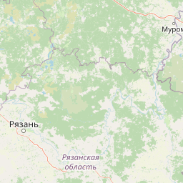
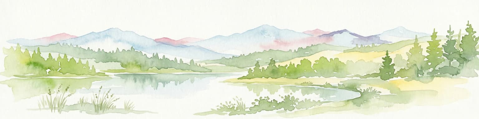
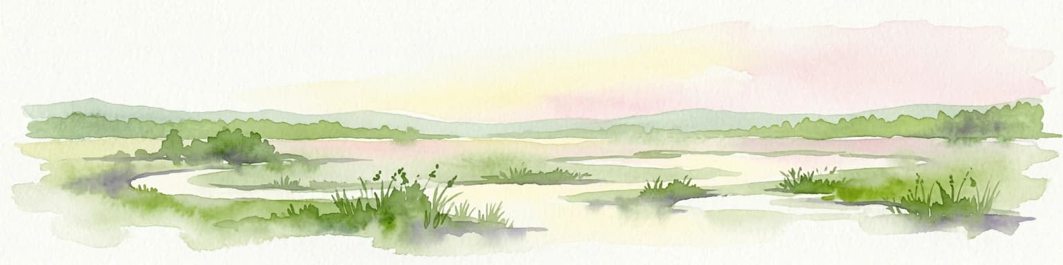
Meshchyorsky National Park is best known for its exceptional wetland ecosystem: a vast network of peat bogs, shallow lakes, rivers, and marshes that form one of the most biodiversity-rich wetland complexes in central Russia. The park protects the Pra River watershed with its distinctive 48-kilometer chain of interconnected lakes, including the prominent Lake Velikoye and the scenic Lake Beloye (White Lake). Its position at the southern edge of the taiga zone creates a unique blend of boreal and temperate species, with notable populations of elk, wild boar, and the recently returned brown bear, along with flourishing beaver communities and seasonal surges of migratory waterfowl including geese and ducks.

Meshchyorsky National Park history and protected-area timeline

The Meshchera Lowlands have long held cultural significance for Russia, attracting artists and writers who captured the distinctive character of its landscapes and rural life. The renowned Russian painter Abram Arkhipov lived in a village within the territory during the late 1800s, producing extensive works depicting the peasant life of the region. Similarly, the Soviet writer Konstantin Paustovsky made his home in the area, drawing inspiration from Meshchyorsky's natural surroundings for his literary works. The park itself was formally established in 1992, creating a protected framework for the region's ecological treasures. Conservation challenges have included recurring forest and peat fires, particularly during dry summer months when the peat-rich soils become highly flammable. Since 2003, the park has implemented an ambitious peatland restoration program, with over 6,000 hectares of degraded peatlands rewetted by 2015, helping to restore natural hydrology and reduce fire risk.

Meshchyorsky National Park landscape and geographic character

The physical landscape of Meshchyorsky National Park is defined by its position within the ancient alluvial valley of the Meshchera Lowlands, a flat depression created by glacial processes during the Quaternary Period. The terrain is exceptionally uniform, with the land surface varying by only 40 meters in elevation across the entire protected area, yet this subtle topography creates conditions for a complex wetland system. The Pra River watershed contains small rivers, streams, and a remarkable 48-kilometer chain of lakes connected by natural channels. The lakes themselves are characteristically shallow, generally remaining under 1.1 meters even at low water, with marshland developing along their shores. Lake Velikoye stands as the largest water body with an open water area of 20.7 square kilometers, followed by Lake Dubovoye at 12.2 square kilometers and Lake Martynovo at 2.46 square kilometers. Where the Pra River meets the Oka River, the floodplain broadens to approximately 10 kilometers in width, creating an expansive wetland mosaic. Agricultural use occupies about 54% of the park's territory, reflecting the long history of human settlement and land use in this relatively accessible region between Moscow and Ryazan.

Meshchyorsky National Park ecosystems, habitats, and plant life

The ecological character of Meshchyorsky National Park reflects its position within the Sarmatic mixed forests ecoregion, a temperate forest belt extending from Norway to the Ural Mountains, transitional between the boreal taiga to the north and more southerly deciduous forests. The park's moderate continental climate (Köppen Dfb) delivers four distinct seasons with high variance between long, cold winters and short, warm, rainy summers, with average temperatures ranging from minus 10 degrees Celsius in January to around 20 degrees Celsius in July and annual precipitation averaging approximately 584 millimeters. Forest composition varies with soil conditions: pine dominates on sandy soils, while birch, aspen, alder, and occasional spruce characterize less sandy areas. As former agricultural lands are retired from production, secondary meadows develop, dominated by sedge species and eventually transitioning to forest through natural succession. Scientists have documented 866 vascular plant species within the park, of which 47 are classified as vulnerable, indicating both the biological richness and conservation concern associated with this wetland landscape.

Meshchyorsky National Park wildlife and species highlights

The wildlife community at Meshchyorsky reflects the park's transitional position at the southern edge of the taiga zone, supporting a mix of boreal and more temperate species. Large mammals present include elk and wild boar, with brown bears having recently returned to the forest edges, representing a notable recovery for this apex predator in the region. Aquatic mammals are well-represented, with beaver populations growing rapidly along with muskrat in the lakes and canal systems. The wetland habitats draw extraordinary concentrations of migratory birds each spring, including large flocks of geese and ducks along with numerous wading bird species inhabiting the marshes. The river and lake systems support diverse fish communities from the Oka River system, including perch, pike, chub, bream, and roach among other species. Conservation concern extends to the greater noctule bat, classified as near threatened and representing one of the park's documented vulnerable animal species.

Meshchyorsky National Park conservation status and protection priorities

Meshchyorsky National Park carries significant conservation importance as part of the "Oka and Pra River Floodplains" Ramsar Convention site, recognizing its wetlands of international importance. The park's zoning system allocates approximately 20% of its territory to strict protection, nearly 50% to ecological restoration, while balancing traditional economic activities and visitor services. A major conservation focus has been the restoration of degraded peatlands, with the park implementing a long-term peatland restoration program since 2003 that had rewetted over 6,000 hectares by 2015. This effort addresses both ecological restoration and fire prevention, as drained peat soils represent a significant fire hazard during dry summer months. The protection of 866 vascular plant species, including 47 classified as vulnerable, and the conservation of wildlife communities ranging from large mammals to migratory waterfowl and bats, positions Meshchyorsky as a critical node in central Russia's environmental protection network.

Meshchyorsky National Park cultural meaning and human context

The Meshchera Lowlands have held cultural significance in Russian history, particularly through the artistic and literary traditions that emerged from this landscape. The park territory was home to Abram Arkhipov, a prominent Russian painter who lived in a local village and extensively documented the peasant life and rural landscapes of the region during the late 1800s. His works provide a visual record of the human relationship with this wetland landscape in the period before formal protection. Similarly, the Soviet writer Konstantin Paustovsky made his home in the area, drawing creative inspiration from Meshchyorsky's natural environment and incorporating the region's distinctive character into his literary output. These cultural connections add historical depth to the park's ecological value, demonstrating how the Meshchera Lowlands have shaped Russian artistic and literary traditions.

Top sights and standout views in Meshchyorsky National Park

Meshchyorsky National Park offers exceptional wetland exploration opportunities across its chain of interconnected lakes, with Lake Velikoye and Lake Beloye providing the centerpiece of the aquatic landscape. The Ramsar-listed floodplains at the confluence of the Pra and Oka rivers create a 10-kilometer-wide wetland corridor that draws spectacular concentrations of migratory birds in spring. The park's mixed pine-birch forests on sandy soils support mammal species including elk, wild boar, and the recently returned brown bear, while beaver and muskrat thrive in the aquatic environments. The peatland restoration program represents a model for wetland conservation in Russia, with over 6,000 hectares successfully rewetted since 2003. Visitors can engage with the park through hiking, cycling, camping, boating, fishing, and seasonal berry and mushroom collecting, while ecological education programs including children's camps and festivals foster environmental awareness.

Best time to visit Meshchyorsky National Park

The optimal time to experience Meshchyorsky National Park depends on seasonal conditions and visitor interests. Spring brings the most dramatic wildlife activity as migratory birds arrive in large numbers, particularly geese and ducks filling the wetlands, though spring flooding can affect some trail accessibility. Summer offers warm conditions ideal for boating, fishing, and camping, though this is also the season of lowest water levels in the shallow lakes and the highest risk of peat and forest fires. Autumn provides excellent opportunities for mushroom and berry collecting in the forests and offers a quieter visitation period with colorful foliage. Winter transforms the landscape dramatically, though the park's accessibility is reduced during the long, cold Russian winter months. The four-season climate means each visit period offers a distinctly different perspective on this wetland ecosystem.

Park location guide

Geography guide, regional context, and park location map for Meshchyorsky National Park

Meshchyorsky National Park park geography, regions, and map view in Russia
Understand where Meshchyorsky National Park sits in Russia through a broader geographic reading of the surrounding landscape, nearby location context, and its mapped position within the national park landscape.

How Meshchyorsky National Park fits into Russia

Russia is a transcontinental nation spanning eleven time zones, bordered by fourteen countries. It is the world's largest country by area, covering 17,098,246 km². Moscow is the capital and largest city, while Saint Petersburg is the second-largest and a major cultural centre.

Wider geography shaping Meshchyorsky National Park in Russia

Russia spans Eastern Europe and North Asia, covering 17,098,246 km². It shares land borders with fourteen countries, more than any other nation, and spans eleven time zones. The landscape includes vast plains, mountain ranges such as the Urals and Caucasus, and extensive coastlines along the Arctic Ocean, Pacific Ocean, Baltic Sea, Black Sea, and Caspian Sea.

Map view of Meshchyorsky National Park

Use this park location map to pinpoint Meshchyorsky National Park in Russia, understand its exact geographic position, and read its mapped placement within the surrounding landscape more clearly.

Pigeon | © OpenStreetMap contributors

Location context for Meshchyorsky National Park

Ryazan Oblast
Park atlas

Compare surrounding protected landscapes and trace the regional wetland geography of central Russia.

Explore Other National Parks and Protected Areas Near Meshchyorsky National Park
After exploring Meshchyorsky National Park, continue your discovery of nearby national parks and protected areas across the Meshchera Lowlands and wider central Russian region. This geographical context allows for detailed comparison of wetland ecosystems, vast peat bogs, and mixed forests within the East European Plain's unique conservation landscapes.
Watercolor painting of a lake surrounded by trees and distant hills
National parkVladimir Oblast

Meshchyora National Park: A Premier Wetland Protected Area in Vladimir Oblast

Explore its mapped boundaries and intricate floodplain geography.

Meshchyora National Park is a key protected landscape in central Russia, renowned for its expansive wetland ecosystems across the Meshchera Lowlands of Vladimir Oblast. Covering nearly 119,000 hectares, the park preserves a unique glacial terrain of peatlands, lakes, and meandering rivers, supporting remarkable biodiversity. Its role as a vital component of the Oka River basin and its conservation focus on restoring degraded peatlands make it a significant site for atlas-based geographic discovery and understanding protected area landscapes.

Area
1,189 km²
Established
1992
IUCN
II
Relief
Lowland
Watercolor illustration of a winding river, trees, and hills in the background
National parkMoscow Oblast

Losiny Ostrov National Park: National Park Protected Landscape in Moscow Oblast

Mapped boundaries and regional geographic context for this protected area.

Uncover the geographic specifics of Losiny Ostrov National Park, a national park situated within the Moscow Oblast. This entry provides detailed insights into the park's protected area designation, its mapped natural landscape, and its position within the regional geography. It serves as a focused point for understanding the protected land's specific features and its atlas value for exploring Russia's diverse natural territories.

Area
116 km²
Established
1983
IUCN
II
Relief
Lowland
National parkYaroslavl Oblast

Pleshcheyevo Ozero National Park: National Park Mapping and Regional Protected Area Atlas

Discover its protected landscape and geographic setting.

Pleshcheyevo Ozero National Park is a key protected area within the geography of Yaroslavl Oblast, Russia. This page offers detailed insights into the park's specific landscape character, its mapped boundaries, and its significance as a national park. It serves as an entry point for understanding the protected lands of the region and exploring its natural terrain within a broader atlas context.

Area
238 km²
Established
1997
IUCN
II
Relief
Lowland
National park

Ugra National Park: Explore Russia's Protected Landscape and National Park Atlas

Mapped boundaries and regional geographic context.

Ugra National Park represents a crucial protected area within Russia, offering detailed geographic context for atlas-based exploration. This entry details the park's specific identity as a national park, highlighting its mapped boundaries and landscape character. Engage with the structured data to understand Ugra National Park's position within Russia's geography and its significance as a protected natural landscape, facilitating comprehensive map exploration.

Area
986,245 km²
Established
1997
IUCN
II
Relief
Lowland
Watercolor illustration of a lake surrounded by forests and mountains under a light sky
National parkTver Oblast

Zavidovo National Park: Exploring its Protected Landscape and Geographic Identity

Mapped protected areas within Tver Oblast's regional geography.

Delve into the specifics of Zavidovo National Park, a designated national park situated within the Tver Oblast. This detailed page provides a geographic lens, allowing for exploration of its protected landscape, mapped boundaries, and its regional context. Understand how this protected area contributes to the larger atlas of Russia's natural environments and discover its unique geographic features through structured, searchable data.

Area
1,329 km²
Established
2015
IUCN
II
Relief
Lowland
National parkRepublic of Mordovia

Smolny National Park: National Park Protected Area and Geographic Context in Republic of Mordovia

Explore the mapped landscape and regional geography of Smolny National Park.

Delve into the specifics of Smolny National Park, a designated national park in Russia's Republic of Mordovia. This detailed atlas view focuses on its protected area identity and geographic setting, providing essential context for understanding its landscape. Discover the mapped boundaries and regional placement that define this protected territory, crucial for any structured exploration of Russian natural areas.

Area
365 km²
Established
1995
IUCN
II
Relief
Lowland
National parkOryol Oblast

Orlovskoye Polesye National Park: National Park Geographic Discovery

Explore protected area maps and regional landscape context.

Delve into the protected landscape of Orlovskoye Polesye National Park, situated within Russia's Oryol Oblast. This page provides detailed geographic information, focusing on its mapped boundaries and its role as a key national park. Understand the unique regional context and how this protected area contributes to the atlas of Russia's natural landscapes. It's an essential resource for exploring the specific geography and mapped terrain of this important conservation area.

Area
777.45 km²
Established
1994
Relief
Lowland
Climate
Temperate
Watercolor illustration of a lake with green forests and grassy foreground, distant hills, and purple and orange water tones
National park

Valdaysky National Park: Russia's National Park & Protected Landscape Explorer

Discover its mapped boundaries and regional geographic context.

Valdaysky National Park represents a significant protected area, offering a focused entry into Russia's natural landscapes. This MoriAtlas page provides detailed geographic context, mapping the park's protected boundaries and its position within the regional terrain. Use this resource to understand the park's unique landscape identity and its value for structured atlas-based discovery of protected lands.

Area
1,585 km²
Established
1990
IUCN
II
Visitors
60K annual

Common questions about visiting, size, designation, and location context for Meshchyorsky National Park

Meshchyorsky National Park FAQs for park facts, access, geography, and protected area context
Find quick answers about Meshchyorsky National Park, including protected-area facts, park geography, trail and visitor context, and how the park fits into its surrounding country and regional landscape.
MoriAtlas Explorer

Continue Your Protected Areas Search Across the Global Atlas

Deepen your exploration by continuing the structured search for national parks and protected areas worldwide. Utilize the comprehensive filtering capabilities to compare different conservation landscapes and refine your understanding of global park geography. Discover more about the distribution and characteristics of protected natural areas.

Global natural geography