
Mori Atlas logo
National parkMeshchyora National Park

Discover the mapped boundaries and unique geography of this national park on the East European Plain.

Meshchyora National Park: Protected Wetland Landscape in Vladimir Oblast

Meshchyora National Park represents a significant protected area within Vladimir Oblast, Russia, safeguarding extensive wetland and forest ecosystems on the East European Plain. Situated in the ancient Meshchera Lowlands, the park's landscape is characterized by a flat, glacial terrain dominated by swamps, peat bogs, rivers, and lakes, covering approximately 118,900 hectares. This national park is a vital component of the Oka River watershed, preserving a rare and ecologically crucial wetland complex that showcases distinct biodiversity and a unique geographic identity.

wetlandspine forestsbirdwatchingglacial landscapepeatlandsecotourism
Illustrated scene featuring a waterfall, surrounding trees, mountains, and a lake under a partly cloudy sky

Meshchyora National Park

National park

Park overview

Structured park overview, official facts, and landscape profile for Meshchyora National Park

Meshchyora National Park park facts, protected area profile, and essential visitor context

Review the core facts for Meshchyora National Park, including designation, size, terrain, visitor scale, habitats, and operating context in one park-focused overview.

About Meshchyora National Park

Meshchyora National Park represents a distinctive protected area in central Russia, characterized by its vast wetlands and temperate forest ecosystems lying on the East European Plain within Vladimir Oblast. The park occupies the Meshchera Lowlands, a flat, ancient alluvial valley shaped by glacial retreat during the Quaternary Period when the Oka, Dnieper, and Moscow glaciers receded, leaving behind glaciofluvial deposits that define the contemporary terrain. Today, the landscape is dominated by meandering rivers including the Buzha and Pol, which flow through slow, winding floodplains before joining the Oka River system. The wetland character of the park is striking—approximately 70 percent of the territory consists of marshes, swamps, peat bogs, rivers, and lakes, creating a complex hydrological system that supports extraordinary biodiversity. The remaining terrestrial areas include pine woodlands on the drier sandy ridges and hills, mixed birch forests, and small pockets of broadleaf forest, particularly oak in the southeastern corner. The park's proximity to Moscow—approximately 120 kilometers to the west—makes it accessible for ecotourism and family recreation, while its ecological significance extends far beyond recreation to encompass important habitat preservation for migratory birds, rare plant communities, and unique wetland ecosystems.

Quick facts and research context for Meshchyora National Park

Meshchyora National Park occupies 118,900 hectares in Vladimir Oblast, roughly 120 kilometers east of Moscow. The terrain is exceptionally flat, with elevation ranging only 35 meters across the entire protected area—from 115 to 150 meters above sea level. Approximately 70% of the territory consists of wetland habitat, including around 24,000 hectares of peatland, of which about 12,000 hectares have been drained for historical peat extraction. The park sits within the Sarmatic mixed forests ecoregion, characterized by a moderate continental climate with four distinct seasons, long winters, and short warm summers. The park is managed by FGBU Meshchyora and was established on April 9, 1992.

Protection and recognition

Verifying documented conservation status and official management frameworks for the reserve

Meshchyora National Park Protection Status and Designated Area Framework

Map-based exploration of Meshchyora National Park requires a clear understanding of its documented protection status and mixed conservation management boundaries. Detailed records of legal designations help conservation researchers and geography enthusiasts trace the official framework safeguarding the regional landscape.

Protection details

Protection scope
Mixed
Transboundary protection
No
Park context

Deeper park guide and search-rich context for Meshchyora National Park

Meshchyora National Park history, landscape, wildlife, and travel context

Explore Meshchyora National Park through its history, landscape character, ecosystems, wildlife, conservation priorities, cultural context, and seasonal travel timing in a structured park guide built for atlas discovery and search intent.

Why Meshchyora National Park stands out

Meshchyora National Park is especially renowned for its extensive wetland ecosystems, a rare feature in central Russia's protected landscape. The park protects one of the largest contiguous wetland complexes in the region, supporting exceptional biodiversity among plants, birds, and aquatic species. The area's peatland habitats, though partially degraded by historical extraction, remain ecologically significant and have been the focus of major restoration efforts since 2003. The park also preserves the cultural heritage of the medieval Meshchera people, a Volga-Finnish tribe whose distinctive identity persisted in these marshlands well into the modern era.
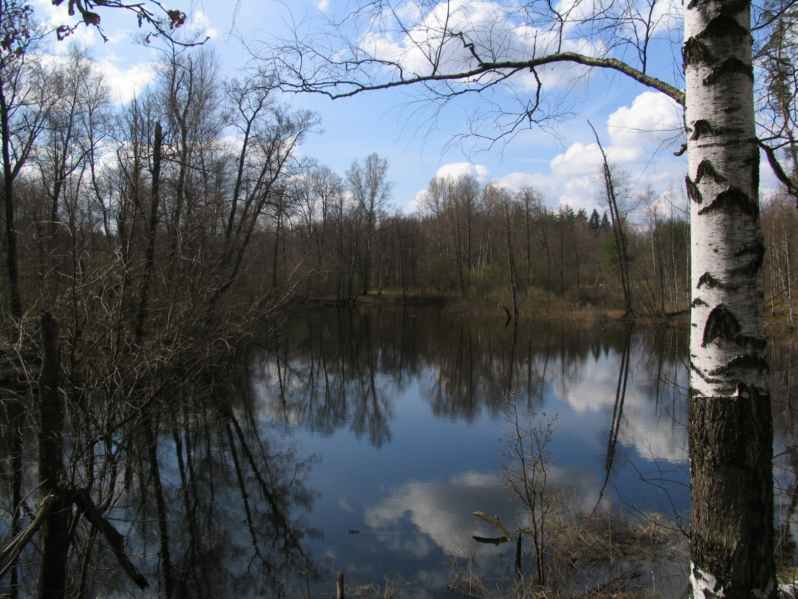
Natural landscape featuring a calm lake reflecting trees and sky, with a birch tree visible on the right side
Calm lake reflecting trees and sky in Meshchyora National Park

Meshchyora National Park history and protected-area timeline

The history of Meshchyora National Park is deeply intertwined with the human history of the Meshchera Lowlands. During medieval times, this area was home to the Meshchera, a Volga-Finnish tribal group who specialized in fishing, hunting, and bronze craftsmanship. The extensive marshlands that characterize the region proved less attractive to the expanding agricultural Slavic populations moving into the area during the 11th and 12th centuries, allowing the Meshchera to preserve their distinctive cultural identity and language relatively late into the historical record—likely until the 16th century. The park was officially established on April 9, 1992, providing formal protection to these significant wetland and forest ecosystems. Contemporary challenges include managing forest fires and peat fires, which pose recurring dangers during dry summer months when the underlying peat deposits create readily flammable conditions. Since 2003, the park has implemented an extensive peatland restoration program aimed at rewetting degraded areas and reducing wildfire vulnerability—by 2015, over 6,000 hectares of degraded peatlands had been restored.

Meshchyora National Park landscape and geographic character

The physical landscape of Meshchyora National Park is defined by its exceptional flatness and wetland dominance. The terrain occupies an ancient alluvial valley formed during the Quaternary Period as major glaciers retreated, leaving behind a landscape with virtually no topographic relief—the entire park varies in elevation by only 35 meters, from 115 to 150 meters above sea level. The highest points consist of glacial moraines left by the retreating ice sheets. The wetland systems are extensive, with approximately 70 percent of the territory classified as wet habitats. About 24,000 hectares consist of peatland, representing deep organic soil deposits formed over millennia in waterlogged conditions. Of this peatland, approximately 12,000 hectares have been historically drained for peat extraction, leaving areas particularly vulnerable to wildfire. The park contains approximately 60 lakes, and the main rivers—the Buzha and Pol—flow through slow, meandering channels that create complex floodplain environments subject to spring flooding and summer low-water periods. The combination of glacial terrain, extensive peat deposits, and the intricate river network produces a landscape of exceptional ecological complexity despite its apparent uniformity.
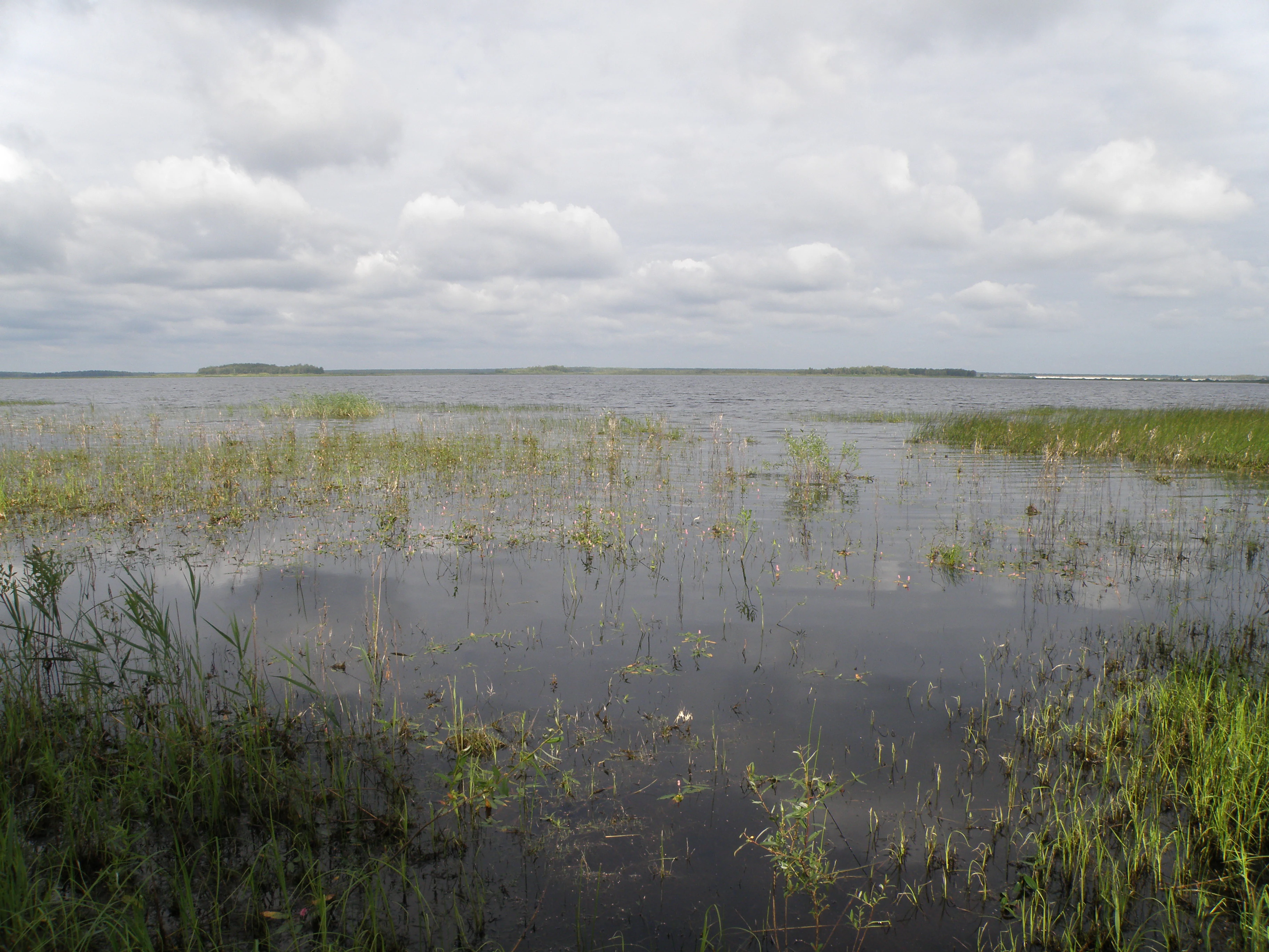
Shallow lake with patches of aquatic plants and grassy shoreline under a cloudy sky
Svyatoe Lake in Meshchyora National Park with shallow water and aquatic vegetation under a partly cloudy sky

Meshchyora National Park ecosystems, habitats, and plant life

The ecological character of Meshchyora National Park centers on its diverse wetland and forest habitats within the Sarmatic mixed forests ecoregion, a temperate forest band stretching from Norway to the Ural Mountains. The park encompasses an unusual combination of excessively wet and relatively dry habitats within close proximity. Pine forests dominate the drier sandy hills and ridges, though mature stands over 100 years old exist only in fragmented patches due to historical logging and fire events. Small areas of broadleaf forest, predominantly oak, are found in the southeastern corner. The majority of wooded areas consist of small-leafed species including birch, maple, and alder. The non-forested areas support meadow, floodplain, and marsh vegetation communities. A comprehensive species inventory recorded 872 vascular plants including 61 mosses, 166 lichen species, and 24 mushroom species. The wetland habitats represent the ecological heart of the park, supporting plant communities adapted to permanent saturation, including moss-covered meadows overrun by reeds and sedge. The climate is moderate continental with four distinct seasons, high variance between winter and summer temperatures, long winters, and short warm rainy summers, with average temperatures ranging from -5°C in January to 23°C in July and annual precipitation around 406 millimeters.
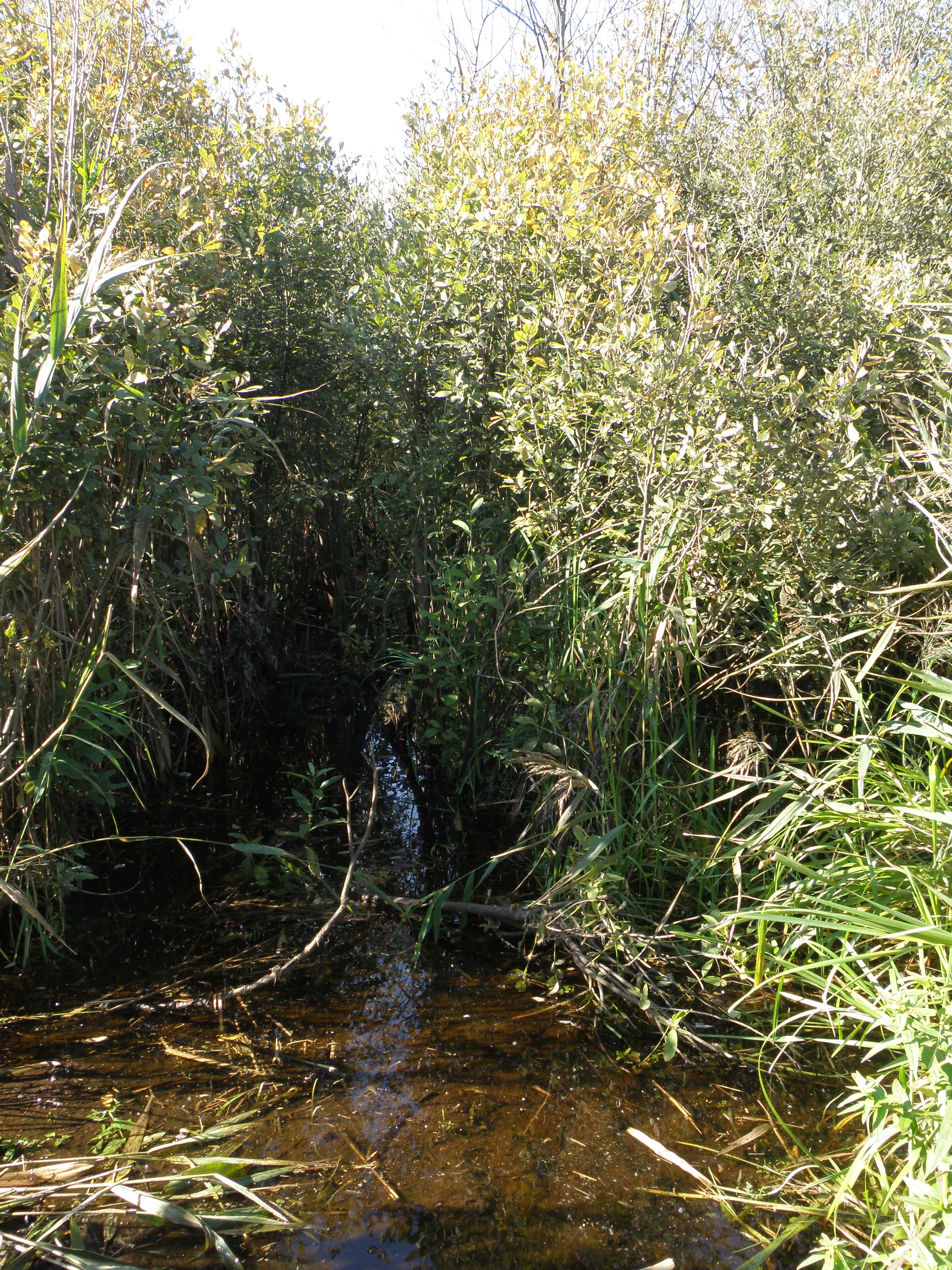
Narrow water channel surrounded by tall reeds and dense vegetation in a wetland area.
Anabranch of the Pol River in the floodplain of Meshchyora National Park.

Meshchyora National Park wildlife and species highlights

The wetland ecosystems of Meshchyora National Park support exceptionally rich wildlife communities, particularly among avian and aquatic species. The park has documented 208 bird species, making it a significant area for birdwatching and migratory bird conservation. The wetland habitats provide critical nesting, feeding, and resting grounds for waterfowl and marsh birds. The aquatic environments are equally biodiverse—the park contains 60 lakes supporting fish populations including northern pike, perch, common roach, and crucian carp. Systematic surveys have recorded 110 aquatic invertebrate species, 26 fish species, and 10 amphibian species. Beavers are common residents and their activities—digging holes and building dams—contribute to the dynamic wetland ecology. The combination of diverse aquatic habitats, extensive reed beds, and surrounding forested areas creates a complex mosaic that supports both water-dependent species and terrestrial wildlife, making the park a significant biodiversity hotspot in central Russia.

Meshchyora National Park conservation status and protection priorities

Meshchyora National Park holds significant conservation value as one of the largest and most ecologically important wetland complexes in central Russia. The protected status under IUCN Category II recognizes the area's national-level significance for biodiversity preservation. The park's wetland ecosystems provide critical habitat for migratory birds, rare plant communities, and specialized aquatic species, functioning as a natural buffer against flooding and a filter for water quality in the Oka River watershed. Major conservation challenges include wildfire management in drained peatland areas, which represent both ecological degradation and fire risk. Since 2003, the park has implemented an ambitious peatland restoration program—over 6,000 hectares of degraded peatlands had been rewetted by 2015, restoring natural hydrological functions and reducing fire vulnerability. The park also participates in broader regional conservation frameworks, with the Russian Ramsar committee noting the park's role in conjunction with adjacent wetland protected areas. About 39 percent of the park territory remains under agricultural use by local communities, requiring careful management to balance conservation objectives with sustainable traditional land use.

Meshchyora National Park cultural meaning and human context

The cultural heritage of Meshchyora National Park is rooted in its association with the medieval Meshchera people, a Volga-Finnish tribal group that inhabited the Meshchera Lowlands during the medieval period. These marshlands were less attractive to expanding agricultural Slavic populations during the 11th and 12th centuries, allowing the Meshchera to maintain their distinctive identity, language, and traditional livelihoods of fishing, hunting, and bronze craftsmanship for centuries longer than many other Finno-Ugric groups in the region. The area retains the tribe's name in both the regional toponym (Meshchera Lowlands) and the park's designation. Contemporary human presence includes local communities who use approximately 39 percent of the park territory for agricultural purposes, representing a long-standing relationship between human communities and this wetland landscape.

Top sights and standout views in Meshchyora National Park

Meshchyora National Park stands out as a premier wetland conservation area in central Russia, protecting one of the region's most extensive and biodiversity-rich wetland complexes. The park's 60 lakes, extensive peat bogs, and meandering rivers create habitat for over 208 bird species and diverse aquatic communities. The Meshchera Lowlands preserve both ecological significance and cultural heritage, named for the Volga-Finnish tribe that maintained their identity here into the 16th century. Major peatland restoration efforts since 2003 have rewetted over 6,000 hectares of degraded areas, demonstrating active conservation management. The flat glacial terrain and ancient alluvial valley produce a distinctive landscape characterized by subtle topography, intricate waterways, and vast wetland scenery atypical for the region.

Best time to visit Meshchyora National Park

The best time to experience Meshchyora National Park depends on the desired activities and landscape character. Spring brings the annual flooding cycle as snowmelt fills the wetlands, creating dynamic water environments and optimal conditions for viewing migratory birds arriving to nest. Summer offers warm temperatures and the opportunity to explore the park's waterways by boat or raft, though dry conditions increase wildfire risk and some areas may experience lower water levels. Autumn provides atmospheric scenery as foliage colors transform the birch and pine woodlands, and migratory waterfowl begin their southward passage. Winter transforms the landscape dramatically, with snow covering the forests and frozen wetlands offering different recreational possibilities. The moderate continental climate means each season presents a distinctly different character—visitors seeking wildlife observation should prioritize spring and early summer, while those interested in wetland exploration and water-based activities will find the warmest months most suitable.
Monthly climate preview

Trace the long term temperature cycles and seasonal precipitation patterns of Vladimir Oblast.

Meshchyora National Park Climate Normals and Monthly Weather Averages

Long term climatological data from a representative park coordinate reveals a continental temperature range, spanning from cold winter means around minus eleven degrees Celsius to peak summer averages near nineteen degrees. Exploring the complete twelve month profile provides detailed daily precipitation rates and minimum temperature thresholds for deeper geographic analysis.
Annual mean4 °C
-11 °C19 °C
Jan-11°
Feb-10°
Mar-4°
Apr
May13°
Jun17°
Jul19°
Aug18°
Sep12°
Oct
Nov-3°
Dec-9°
Warmest month
July

19.4 °C

Coolest month
January

-11 °C

Wettest month
June

2.7 mm/day

Driest month
March

1.3 mm/day

Park location guide

Geography guide, regional context, and park location map for Meshchyora National Park

Meshchyora National Park park geography, regions, and map view in Russia

Understand where Meshchyora National Park sits in Russia through a broader geographic reading of the surrounding landscape, nearby location context, and its mapped position within the national park landscape.

How Meshchyora National Park fits into Russia

Russia is a transcontinental nation spanning eleven time zones, bordered by fourteen countries. It is the world's largest country by area, covering 17,098,246 km². Moscow is the capital and largest city, while Saint Petersburg is the second-largest and a major cultural centre.

Wider geography shaping Meshchyora National Park in Russia

Russia spans Eastern Europe and North Asia, covering 17,098,246 km². It shares land borders with fourteen countries, more than any other nation, and spans eleven time zones. The landscape includes vast plains, mountain ranges such as the Urals and Caucasus, and extensive coastlines along the Arctic Ocean, Pacific Ocean, Baltic Sea, Black Sea, and Caspian Sea.

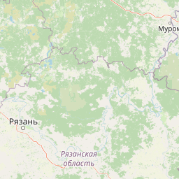
Map view of Meshchyora National Park

Use this park location map to pinpoint Meshchyora National Park in Russia, understand its exact geographic position, and read its mapped placement within the surrounding landscape more clearly.

Pigeon | © OpenStreetMap contributors

Location context for Meshchyora National Park

Vladimir Oblast

Discover the unique topography, diverse wetland habitats, and protected-area character through stunning imagery of this central Russian park.

Meshchyora National Park Photos: Visual Exploration of Russia's Extensive Wetland Landscapes and Forest Scenery

Browse a curated collection of Meshchyora National Park photos to visually comprehend its defining features, from the vast peat bogs and meandering rivers to the ancient pine and birch woodlands. These images provide an essential visual atlas, illustrating the park's exceptional flatness, complex wetland ecosystems, and the unique ecological identity of this significant protected landscape in central Russia.

Natural landscape featuring a calm lake reflecting trees and sky, with a birch tree visible on the right side

A river with reflective water flowing through a grassy landscape surrounded by tall pine trees under a partly cloudy sky

Shallow lake with patches of aquatic plants and grassy shoreline under a cloudy sky

Narrow water channel surrounded by tall reeds and dense vegetation in a wetland area.

Park atlas

Explore the Regional Protected Landscapes and Wetland Geography Surrounding Meshchyora National Park in Central Russia

Discover Other National Parks and Protected Areas Near Meshchyora National Park

Browse additional national parks and protected areas situated near Meshchyora National Park, enabling comparative exploration of wetland and forest landscapes across central Russia. This regional atlas view illuminates the distribution of protected ecosystems and their conservation strategies throughout the diverse East European Plain.
A horizontal watercolor painting depicting a gentle river flowing through a forested landscape with soft rolling hills in the background.
National parkVladimir Oblast
About 0.7 km away#1 closest

South

Мещёра National Park: A Study of Glacial Lowland Geography and Protected Forest Landscapes

A diverse protected mosaic in Vladimir Oblast, Russia.

Focusing on the flat, sandy expanses of the Meshchera Plain, this national park showcases a unique transition zone between taiga and nemoral forests. The area is characterized by its slow meandering rivers, numerous glacial lakes, and extensive peat bog systems that provide a benchmark for regional ecological preservation.

Area
2,239 km²
Established
1992
IUCN
II
Relief
Lowland
A watercolor painting showing a soft, hazy landscape of pine trees alongside a body of water, rendered in shades of green, light pink, and soft purple.
National parkЯмало-Ненецкий автономный округ
About 49 km away#2 closest

South

Мещёрский национальный парк: Geographic Atlas and Protected Area Boundaries

Detailed mapping of the Meshchera Lowland wetland mosaic

Understand the protected geography of Мещёрский национальный парк, an essential conservation area containing complex peat bogs, expansive mixed forests, and the vital floodplain of the Pra River. This record provides a clear perspective on the park's terrain, hydrological features, and its status as a significant natural landmark within the broader Meshchera region.

Area
1,050.14 km²
Established
1992
IUCN
II
Visitors
5K annual
National parkRyazan Oblast
About 49 km away#3 closest

South

Meshchyorsky National Park: Ryazan Oblast Protected Landscape Exploration

National park geography and mapped terrain.

Investigate Meshchyorsky National Park, a key protected area situated in Ryazan Oblast, Russia. This page provides detailed atlas-level context, focusing on the park's geographic identity, its mapped boundaries, and its role as a national park within the regional landscape. Explore the natural terrain and discover the protected land's place in Central Russia's geography through structured data and mapping.

Area
66 km²
Established
1992
IUCN
II
Relief
Lowland
Watercolor illustration of a winding river, trees, and hills in the background
National parkMoscow Oblast
About 145 km away#4 closest

West

Losiny Ostrov National Park: Mapping the Boundaries of a Unique Urban Wilderness

Protected forest and wetland geography in Moscow Oblast.

Spanning over 116 square kilometers, Losiny Ostrov National Park represents a significant conservation effort as Europe's largest urban national park. Its geography encompasses dense mixed forests, the Upper Yauza Swamps, and a convergence of regional watersheds, providing a rare study of wilderness persistence within a densely populated metropolitan environment.

Area
116 km²
Established
1983
IUCN
II
Relief
Lowland
Watercolor illustration of a soft forest landscape with green trees, rolling hills, and a winding path in muted green and yellow tones.
National parkMoscow
About 145 km away#5 closest

West

Losiny Ostrov National Park: Geography and Protected Landscapes in Moscow, Russia

Mapped forest terrain, wetland systems, and urban conservation zones.

Spanning from the Moscow city fringe into the surrounding landscape, Losiny Ostrov National Park protects a vital mixture of peat bogs, river headwaters, and dense mixed forests. This historic terrain offers a deep look at how large-scale conservation survives within a metropolitan environment, hosting free-roaming moose and diverse mammals while preserving ancient woodland corridors.

Area
128.81 km²
Established
1983
IUCN
II
Relief
Lowland
A horizontal watercolor painting depicting a calm lake with grassy banks and soft rolling hills in the background.
National parkЯмало-Ненецкий автономный округ
About 163 km away#6 closest

Northwest

Плещеево озеро National Park: Glacial Lake Geography and Protected Area Atlas

Mapped terrain, forest mosaic, and Upper Volga basin protected landscapes.

Плещеево озеро National Park centers on a significant glacial lake, framed by an ecological mosaic of boreal and broadleaf forests, extensive peat bogs, and coastal wetlands. This protected area within the Upper Volga basin offers a look at a layered natural environment where diverse bird populations, endemic fish, and historical landmarks meet across the East European Plain.

Area
237.9 km²
Established
1988
IUCN
II
Relief
Lowland
Watercolor painting showing a lake with grasses in the foreground and distant shoreline
National parkYaroslavl Oblast
About 163 km away#7 closest

Northwest

Pleshcheyevo Ozero National Park: National Park Mapping and Regional Protected Area Atlas

Discover its protected landscape and geographic setting.

Pleshcheyevo Ozero National Park is a key protected area within the geography of Yaroslavl Oblast, Russia. This page offers detailed insights into the park's specific landscape character, its mapped boundaries, and its significance as a national park. It serves as an entry point for understanding the protected lands of the region and exploring its natural terrain within a broader atlas context.

Area
238 km²
Established
1997
IUCN
II
Relief
Lowland
National parkMoscow Oblast
About 274 km away#8 closest

West

Zavidovo National Park: Mapping the Protected Landscapes of the Upper Volga Lowland

A study of glacial plains, forest mosaics, and riverine habitats.

Zavidovo National Park occupies a sprawling area of the Upper Volga Lowland, characterized by gentle relief and an exceptional concentration of water-based habitats. The park serves as a prime example of a managed conservation territory that integrates river valleys, lowland forests, and marshlands. Its geographic identity remains deeply rooted in the glacial history of central Russia, supporting a continuous protected block within the Moscow Oblast.

Area
1,250 km²
Established
1972
IUCN
II
Relief
Lowland

Common questions about visiting, size, designation, and location context for Meshchyora National Park

Meshchyora National Park FAQs for park facts, access, geography, and protected area context

Find quick answers about Meshchyora National Park, including protected-area facts, park geography, trail and visitor context, and how the park fits into its surrounding country and regional landscape.
MoriAtlas Explorer

Continue Your Protected Areas Search Across the Global Atlas

Deepen your exploration by continuing the structured search for national parks and protected areas worldwide. Utilize the comprehensive filtering capabilities to compare different conservation landscapes and refine your understanding of global park geography. Discover more about the distribution and characteristics of protected natural areas.

Global natural geography