
Rock formations
Park geography
Understanding the landscape composition, regional distribution, and natural features of Gabon's protected upland territory.
Minkébé National Park Geographic Profile, Boundary Mapping, and Terrain Characteristics
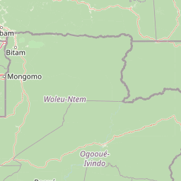
Minkébé National Park encompasses 7570 square kilometers of upland terrain within the Woleu-Ntem Province of Gabon. This geography profile details the extensive forest cover, wetland habitats, and river networks of the Oua, Ayina, and Mvoung, alongside significant geological formations like the Inselberg de Minkébé and Mont Misséké.
Related tags
National ParkLowland ForestForest ElephantsPrimatesCentral Africa
A vast central African lowland forest sanctuary protecting one of Africa's largest forest elephant populations
Minkébé National Park
Minkébé National Park is a vast protected area in the extreme northeast of Gabon, covering approximately 7,570 square kilometers of pristine lowland tropical forest. Established as a national park in August 2002 after initial provisional protection in 2000, this park represents one of the most significant conservation areas in central Africa. The park forms part of the broader TRIDOM transboundary conservation initiative connecting protected areas across Gabon, Cameroon, and the Republic of the Congo, creating a contiguous forest complex spanning roughly 140,000 square kilometers. The landscape is characterized by ancient forest dominated by isolated rock domes, extensive marshy areas, and four major river systems that traverse the terrain. The name Minkébé derives from the Fang language term "minkegbe," meaning valleys or ditches, reflecting the region's distinctive topography.
- Location
- Gabon
- Park type
- National park
- Established
- 2002
- Area
- 7,570 km²
Location overview
Regional position within the Woleu-Ntem Province of Gabon
Geographic Location and Regional Setting of Minkébé National Park
Minkébé National Park is located entirely within Gabon, situated in the Woleu-Ntem Province. The protected area is positioned within a single national jurisdiction without crossing international borders.
- Countries
- Gabon
- Regions
- Woleu-Ntem Province
- Primary location
- Gabon
Boundary and coordinates
Minkébé National Park’s outline encompasses 7,570 km²
Minkébé National Park mapped boundary and 7,570 km² area
Minkébé National Park has atlas geometry spanning a documented 7,570 km². The expansive footprint conveys the park’s geographic reach and scale without representing official survey boundaries.
- Boundary area
- 7,583.5 km²
- Boundary perimeter
- 699.3 km
- Northernmost point
- 2.2868° N
- Southernmost point
- 1.1697° N
- Easternmost point
- 13.3056° E
- Westernmost point
- 12.2212° E
- Geographic centre
- 1.6769° N, 12.7612° E
- North–south span
- 123.5 km
- East–west span
- 120.7 km
Terrain and natural features
Upland terrain classifications and recorded within-park natural features
Minkébé National Park Terrain and Named Natural Features
Minkébé National Park features upland terrain classifications alongside recorded features like Mont Misséké and the Mvoung River. Linked feature cards supply names, types, measurements, and spatial relationships for each entry.
Selected named natural features
Rivers
Mvoung River
Rivers
Oua River
Rock formations
Rocher
Peaks
Mont Misséké
936 m
Rivers
Ayina
Environmental setting
Tropical forest coverage, upland relief, and major water systems
Minkébé National Park Environmental Classifications and Physical Setting
Stored landscape features, habitat types, and climate zones offer complementary ways to read the physical setting of Minkébé National Park. Recorded categories connect directly to relevant atlas destinations across the protected terrain.
- Relief
- Upland
- Climate
- Tropical
- Water
- Major water bodies
- Forest cover
- Mostly forested
Landscape features
Forest · Valleys · Wetland · Marsh · Rivers · Grassland · Cliffs
Habitat types
Tropical forest · Wetland · Riverine habitat · Grassland
Park atlas
Trace connected forest complexes and conservation landscapes within the broader Central African region
Discover Other National Parks and Protected Areas Near Minkébé National Park in Central Africa
Browse national parks and protected areas situated near Minkébé National Park, revealing diverse lowland forest ecosystems and unique inselberg terrain. Compare their geographic spread, conservation landscapes, and shared wildlife populations within the broader Central African region, enriching your atlas discovery.
Biosphere reserveGabon
About 73 km away#1 closest
South

Ipassa-Makokou Biosphere Reserve: Gabon Geographic and Ecological Profile
Protected tropical lowland forest along the Ivindo River
Situated in northeastern Gabon, the Ipassa-Makokou Biosphere Reserve protects a vital segment of the Congolese-Guinean rainforest. This area provides deep insight into forest dynamics through decades of consistent monitoring, showcasing an unbroken canopy and high biodiversity density within a key Central African corridor.
- Area
- 150 km²
- Established
- 1983
National parkCameroon
98 km away#2 closest
Northeast

Nki National Park: Protected National Park Landscape in Cameroon
Explore the geographic context and mapped boundaries.
Nki National Park is a designated national park in Cameroon, offering a distinct protected landscape for geographic study. This page provides essential context for understanding the park's place within the country's natural geography and protected areas atlas. Explore its mapped terrain and protected boundary details to gain a clearer picture of this natural entity within Central Africa's diverse geography.
- Area
- 3,093 km²
- Established
- 2005
- IUCN
- II
- Relief
- Upland
National parkGabon
About 120 km away#3 closest
South
Ivindo National Park: A Protected Rainforest Landscape in Gabon
Explore its waterfalls, diverse ecosystems, and mapped geographic context.
Ivindo National Park represents a significant protected landscape within Gabon, spanning a vast area of intact tropical rainforest. Recognized as a UNESCO World Heritage Site, the park is defined by the Ivindo River and its dramatic waterfalls, including the famous Kongou and Mingouli Falls. Its geography includes mountainous terrain and vital riverine ecosystems, supporting critical populations of forest elephants and great apes. This page offers a gateway to understanding the park's protected status, its unique natural features, and its role in the broader geography of Central Africa.
- Area
- 3,000 km²
- Established
- 2002
- IUCN
- II
- Relief
- Mixed relief
National parkEquatorial Guinea
About 123 km away#4 closest
West

Altos de Nsork National Park: Equatorial Guinea's Protected Landscape and Map Context
Explore the mapped boundaries of this national park.
Altos de Nsork National Park stands as a designated national park within Equatorial Guinea, offering a distinct protected landscape. This entry provides essential atlas-driven details, emphasizing its geographic setting and mapped park boundaries. Understand its regional context and its significance as part of the conservation network in Central Africa, contributing to a richer understanding of mapped natural terrains.
- Area
- 700 km²
- Established
- 2000
- IUCN
- II
- Relief
- Highland
National parkCuvette-Ouest Department
126 km away#5 closest
East

Odzala-Kokoua National Park National Park: Mapped Protected Landscape in Cuvette-Ouest
Explore its geographic boundaries and regional terrain.
Odzala-Kokoua National Park is a key national park entity, offering a distinct protected landscape within the Cuvette-Ouest Department. This page provides an atlas-style exploration of its mapped boundaries and geographic context. Delve into the specifics of this protected area to understand its contribution to the regional geography and natural landscape, facilitating structured discovery of its terrain.
- Area
- 13,500 km²
- Established
- 1935
- IUCN
- II
- Visitors
- 50 annual
National parkGabon
About 129 km away#6 closest
Southeast
Mwangné National Park: Gabon's Protected Landscape for Geographic Discovery
Explore the mapped boundaries and regional context.
Gain a detailed understanding of Mwangné National Park, a key protected area within Gabon. This page offers an atlas-centric view, highlighting its geographic significance and the characteristics of its protected landscape. Delve into the park's mapped boundaries and its role within the broader natural terrain of Central Africa, providing essential context for geographic exploration.
National parkGabon
154 km away#7 closest
Southwest
Lopé National Park: Gabon's Protected Landscape and National Park Geography
Explore mapped boundaries and natural terrain in Central Africa.
Delve into Lopé National Park, a designated national park situated in Gabon. This protected area serves as a crucial point for understanding the nation's geography and the distribution of its conservation landscapes. As an entry in the MoriAtlas, it offers a detailed view of its mapped territory and its contribution to the broader regional context of Central Africa, emphasizing its role in protected area atlas exploration.
- Area
- 4,910 km²
- Established
- 2002
- IUCN
- II
- Relief
- Mixed relief
National parkEast Province
164 km away#8 closest
East
Boumba Bek National Park: National Park with Protected Landscape Identity in East Province
Explore its geographic context and mapped protected boundaries.
Boumba Bek National Park is a key protected area within Cameroon's East Province, offering a dedicated focus for understanding national park landscapes. This resource facilitates discovery of its precise geographic footprint and its significance as a mapped protected land. Users can delve into its regional context and explore the atlas-level details defining its protected status and natural landscape character.
- Area
- 2,382 km²
- Established
- 2005
- IUCN
- II
- Relief
- Lowland
MoriAtlas Explorer
Continue Exploring Minkébé National Park's Mapped Landscape and Geography
Delve deeper into the structured atlas data for Minkébé National Park. Understand how its protected boundaries contribute to the regional geography of Gabon and Central Africa. This focused exploration reveals the distinct natural terrain and landscape identity essential for comprehending protected areas across the continent.
Browse next
Global natural geography
Explore related park routes
Explore MoriAtlas Global ParksBrowse All MoriAtlas ParksGlobal Park Map DiscoveryMoriAtlas: Browse All CountriesBrowse All MoriAtlas ContinentsNational Park Environment AtlasGrand Canyon National Park AtlasYellowstone National Park AtlasYosemite National Park Atlas and GeographySerengeti National Park AtlasGalápagos National Park Protected LandscapeBanff National Park Geography and AtlasKruger National Park Atlas EntryUluṟu-Kata Tjuṯa National Park AtlasExplore Uluru-Kata Tjuta National Park GeographyPlitvice Lakes National Park AtlasFiordland National Park Protected LandscapeGreat Smoky Mountains National Park AtlasAfghanistan National Parks and Protected AreasAlbania National Parks and Protected AreasAlgeria National Parks and Protected AreasAmerican Samoa National Parks and Protected AreasAndorra National Parks and Protected AreasAngola National Parks and Protected AreasAntarctica National Parks and Protected AreasAntigua and Barbuda Park List