Mori Atlas logo
Biosphere reserveMontañas Mayas Chiquibul

A regional geographic study of karst terrain, forested ridges, and transboundary conservation corridors.

Montañas Mayas Chiquibul Biosphere Reserve: Mapping the Protected Landscapes of the Maya Mountains in El Petén

Montañas Mayas Chiquibul represents a significant biosphere reserve situated within the El Petén department of Guatemala. This protected area bridges the lowland limestone plains and the rugged Maya Mountain uplands, forming a critical ecological link across the regional landscape. Through its dense forest cover and complex karst topography, the reserve maintains essential watershed functions and provides a expansive habitat network that connects with broader Central American corridors.

biosphere reserveMaya Mountainstropical forestkarst landscapePeténCentral America

Montañas Mayas Chiquibul

Biosphere reserve

Park overview

Structured park overview, official facts, and landscape profile for Montañas Mayas Chiquibul

Montañas Mayas Chiquibul park facts, protected area profile, and essential visitor context

Review the core facts for Montañas Mayas Chiquibul, including designation, size, terrain, visitor scale, habitats, and operating context in one park-focused overview.

About Montañas Mayas Chiquibul

Montañas Mayas Chiquibul is one of Guatemala's largest protected natural areas, occupying a major portion of the department of El Petén in the north of the country. The reserve extends across the municipalities of San Luis, Poptún, Dolores, and Melchor de Mencos, covering roughly 1,236 square kilometers of largely forested terrain. Its position along the border with Belize places it within the broader Maya Mountain system, a mountain chain that runs across northern Central America and supports some of the region's most intact forest cover.

The landscape of the reserve is shaped by karst geology typical of the Yucatán Platform, combined with the steeper, more elevated terrain of the Maya Mountains foothills. This creates a varied setting of rolling hills, ridges, sinkholes, cave systems, and river valleys covered in tropical broadleaf forest. The combination of elevation, rainfall patterns, and soil diversity gives the area a complex ecological profile, where lowland rainforest elements blend with species and habitats more typical of upland and mid-elevation environments.

As a biosphere reserve, Montañas Mayas Chiquibul is designed to function as a multiple-use protected area, balancing conservation of biodiversity and watershed values with the presence of rural communities and traditional land uses within and around the reserve. Its management falls under CONAP, Guatemala's national authority for protected areas, and the reserve was established through Decreto Legislativo 64-95. The area's ecological significance is tied not only to its large size and habitat diversity, but also to its position as part of a transboundary corridor connected to protected landscapes in Belize, making it strategically important for regional conservation in the Maya Mountain region.

Quick facts and research context for Montañas Mayas Chiquibul

Montañas Mayas Chiquibul is a biosphere reserve located in El Petén, the northernmost department of Guatemala. It covers roughly 1,236 square kilometers across four municipalities, making it one of the larger protected areas in the country.

The reserve is administered by CONAP, Guatemala's national council for protected areas, and was formally established through Decreto Legislativo 64-95. Its setting places it within the Maya Mountains system, at the interface between the karst lowlands of Petén and the higher terrain extending toward Belize.

Park context

Deeper park guide and search-rich context for Montañas Mayas Chiquibul

Montañas Mayas Chiquibul history, landscape, wildlife, and travel context

Explore Montañas Mayas Chiquibul through its history, landscape character, ecosystems, wildlife, conservation priorities, cultural context, and seasonal travel timing in a structured park guide built for atlas discovery and search intent.

Why Montañas Mayas Chiquibul stands out

Montañas Mayas Chiquibul is best known for its expansive tropical forests, its position within the Maya Mountain ecosystem, and its role as one of Guatemala's most significant forest reserves in the Petén region. The biosphere reserve is closely associated with the broader Chiquibul landscape, an area recognized for its biodiversity value, karst terrain, and hydrological importance. It sits at the junction of lowland rainforest and upland forest, creating a transitional zone that supports varied plant and animal communities.

Montañas Mayas Chiquibul history and protected-area timeline

Montañas Mayas Chiquibul was established as a protected area under Decreto Legislativo 64-95, an act of the Guatemalan legislature that formalized its designation. The reserve was created to protect a significant portion of the northern Petén forests at a time when Guatemala was expanding its national system of protected areas in response to deforestation pressures and growing recognition of the region's biodiversity value.

The reserve's placement in El Petén links it historically and ecologically to a long tradition of conservation in the Maya region, where forest loss and land-use change have shaped management priorities for decades. Its creation under CONAP, the national council for protected areas, reflects the country's institutional framework for managing biosphere reserves and other large protected landscapes.

The name Montañas Mayas Chiquibul reflects both the geographic setting within the Maya Mountain chain and the Chiquibul landscape that extends across the border into Belize, indicating that the reserve has long been understood as part of a broader, transboundary natural region.

Montañas Mayas Chiquibul landscape and geographic character

The landscape of Montañas Mayas Chiquibul is defined by the southern foothills of the Maya Mountains, where terrain rises from the relatively flat limestone plains of the Petén into rolling karst uplands. This transition produces a varied topography of ridges, valleys, sinkholes, and cave formations, characteristic of the Yucatán Platform's geological structure.

The reserve's higher elevations support denser, more humid forest conditions, while lower-lying areas include flatter terrain shaped by river systems and seasonal drainage patterns. The combination of karst features and forested slopes gives the reserve a distinctive scenery of green ridgelines, hidden sinkholes, and forested river corridors.

Montañas Mayas Chiquibul ecosystems, habitats, and plant life

The reserve protects a substantial block of tropical forest within the Maya Mountain ecosystem, an area known for its biological richness. Vegetation ranges from broadleaf lowland rainforest in lower zones to more humid, montane-influenced forest on higher slopes, reflecting the elevational and climatic gradients present across the protected area.

The forest cover supports complex habitat mosaics that include riparian corridors along rivers, upland ridge forest, and karst-specialized plant communities. This habitat diversity is fundamental to the reserve's ecological role, providing refuge for species sensitive to forest disturbance and supporting a wide range of ecological processes linked to the region's watersheds and forest interior conditions.

Montañas Mayas Chiquibul wildlife and species highlights

Montañas Mayas Chiquibul's extensive forest cover and habitat diversity make it an important area for wildlife in northern Guatemala. The reserve provides habitat for forest-dependent species typical of the Maya Mountain and Petén region, including mammal, bird, reptile, and amphibian communities associated with mature tropical forest.

Connectivity with forested landscapes across the border in Belize strengthens the reserve's value for wide-ranging species, allowing animal populations to move across a broader landscape. This transboundary ecological context is a defining feature of the wildlife significance of Montañas Mayas Chiquibul, linking it to one of the more important forest blocks remaining in Central America.

Montañas Mayas Chiquibul conservation status and protection priorities

As a biosphere reserve, Montañas Mayas Chiquibul is recognized for its role in protecting a large block of tropical forest within the Maya Mountain ecosystem. The reserve contributes to safeguarding watersheds, maintaining forest cover, and preserving habitat connectivity across the Guatemala-Belize border, a region under significant pressure from agricultural expansion and other land-use changes.

Its management by CONAP places it within Guatemala's national system of protected areas, reflecting an institutional commitment to long-term conservation of the Petén forests. The reserve's size, location, and ecological character give it regional importance for biodiversity conservation in Central America.

Montañas Mayas Chiquibul cultural meaning and human context

The name Montañas Mayas Chiquibul reflects the reserve's deep connection to the Maya cultural region of northern Central America. El Petén, the department where the reserve is located, has long been recognized as a heartland of Maya civilization, with a landscape shaped by centuries of human history, settlement, and interaction with the forest environment.

The rural municipalities of San Luis, Poptún, Dolores, and Melchor de Mencos that surround and overlap with the reserve are part of this broader cultural geography, where contemporary communities live alongside a landscape long associated with Maya heritage.

Top sights and standout views in Montañas Mayas Chiquibul

Montañas Mayas Chiquibul stands out as one of Guatemala's largest biosphere reserves, protecting a major expanse of Maya Mountain forest within El Petén. Its combination of karst topography, tropical forest cover, and transboundary ecological connections gives it strong identity as a Central American conservation landscape.

The reserve's role in watershed protection, habitat connectivity with Belize, and preservation of Maya region forests makes it a cornerstone of Guatemala's protected areas system and a meaningful site for understanding the natural heritage of northern Central America.

Best time to visit Montañas Mayas Chiquibul

The dry season, generally running from roughly late November through April, tends to offer more accessible conditions across the Petén region, with reduced rainfall, firmer forest trails, and clearer visibility for landscape observation. This period is often considered favorable for appreciating the forested scenery of the Maya Mountains foothills.

The wet season, from about May through October, brings heavier rainfall that can make trails and rural roads more difficult, but it also corresponds with the peak of forest greenery and active wildlife periods. For visitors interested in lush forest conditions and seasonal ecological change, this period has its own character, though conditions are generally more challenging for overland travel.

Monthly climate preview

Long-term representative monthly averages and temperature ranges across the protected landscape

Montañas Mayas Chiquibul Climate Normals, Annual Temperature and Precipitation Patterns

Representative coordinates record measured monthly temperature swings from 21.06 degrees Celsius to 26.74 degrees Celsius alongside shifting daily precipitation rates. Examining the full twelve-month profile reveals complete long-term climate normals for the protected landscape.
Annual mean24 °C
21 °C27 °C
Jan21°
Feb22°
Mar24°
Apr27°
May27°
Jun25°
Jul25°
Aug25°
Sep25°
Oct24°
Nov22°
Dec21°
Warmest month
May

26.7 °C

Coolest month
January

21.1 °C

Wettest month
October

7.3 mm/day

Driest month
April

1.4 mm/day

Park location guide

Geography guide, regional context, and park location map for Montañas Mayas Chiquibul

Montañas Mayas Chiquibul park geography, regions, and map view in Guatemala

Understand where Montañas Mayas Chiquibul sits in Guatemala through a broader geographic reading of the surrounding landscape, nearby location context, and its mapped position within the national park landscape.

How Montañas Mayas Chiquibul fits into Guatemala

Guatemala is a presidential republic in Central America with a population of approximately 18.6 million, making it the most populous country in the region. The country was the heartland of the Maya civilization and gained independence from Spain in 1821. Guatemala has a diverse population including Maya, Ladino, Xinca, and Afro-Guatemalan communities, with Spanish as the official language.

Wider geography shaping Montañas Mayas Chiquibul in Guatemala

Guatemala is located in northern Central America, bordered by Mexico to the north and west, Belize to the northeast, Honduras to the east, El Salvador to the southeast, and the Pacific Ocean to the south. The terrain is predominantly mountainous with highlands, volcanic ranges, and coastal lowlands. The country includes the Petén region, a large lowland jungle area in the north.

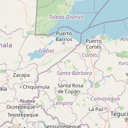
Map view of Montañas Mayas Chiquibul

Use this park location map to pinpoint Montañas Mayas Chiquibul in Guatemala, understand its exact geographic position, and read its mapped placement within the surrounding landscape more clearly.

Pigeon | © OpenStreetMap contributors

Location context for Montañas Mayas Chiquibul

El Petén
Park atlas

Compare regional geography, tropical forest corridors, and karst topography.

Parks Near Montañas Mayas Chiquibul and Surrounding Protected Landscapes

Browse other parks near Montañas Mayas Chiquibul to examine connected forest reserves across the surrounding region. Comparing adjacent protected landscapes reveals broader patterns in regional geography and tropical conservation corridors.
National parkCayo District
About 3.7 km away#1 closest

Northeast

Chiquibul National Park: Detailed Protected Area and National Park Geography

Explore mapped boundaries within Belize's Cayo District.

Chiquibul National Park offers a critical lens through which to view Belize's protected natural areas. As a designated national park located in the Cayo District, it provides essential data for understanding the extent and geographic positioning of conservation landscapes. Users can engage with detailed map information to trace the park's borders and appreciate its role within the national atlas of protected territories.

Area
1,073 km²
Established
1995
IUCN
II
Relief
Mountain
A stylized vector illustration of tiered Mayan pyramid structures rising above a dense green jungle landscape under a soft pastel sky.
Biosphere reservePetén Department
About 39 km away#2 closest

Northwest

Maya Biosphere Reserve: Geographic Overview and Protected Landscapes in Petén

Tropical forest ecosystems and ancient archaeological mapping

Covering roughly one-fifth of Guatemala, the Maya Biosphere Reserve represents a pioneering model of zoned conservation. The landscape features a complex mosaic of lowland rainforests, savanna patches, and seasonal wetlands formed over a weathered limestone platform. This atlas summary examines the reserve's ecological boundaries, its vital role in protecting Mesoamerican biodiversity, and the concentration of pre-Columbian cities located across the Petén Department.

Area
21,602 km²
Established
1990
Relief
Mixed relief
Climate
Tropical
National parkCayo District
About 57 km away#3 closest

North

Elijio Panti National Park: Protected Landscape and Regional Geography in Cayo District

Explore the mapped boundaries and geographic features of this national park.

Elijio Panti National Park offers a unique focus on protected landscape discovery within Belize. Situated in the Cayo District, this national park provides a specific geographic anchor for understanding natural terrain and mapped boundaries. The page details its identity as a protected area, contributing to a structured atlas of conservation lands and regional geography.

Area
52.645 km²
Established
2001
IUCN
II
Relief
Mountain
National parkToledo District
About 60 km away#4 closest

South

Sarstoon-Temash National Park: National Park Geography and Mapped Boundaries

Explore the protected landscape of Toledo District.

Sarstoon-Temash National Park is a key protected area located in Belize's Toledo District. As a national park, it offers distinct geographic features and mapped boundaries that are crucial for understanding regional conservation landscapes. This entry provides detailed context on its protected status and geographic setting, enabling a more profound atlas-based exploration of the natural terrain and its significance.

Area
165.92 km²
Established
1994
IUCN
II
Relief
Lowland
National parkToledo District
About 62 km away#5 closest

East

Payne's Creek National Park: National Park Protected Landscape and Geographic Atlas

Explore mapped boundaries and regional geography in Toledo District.

Payne's Creek National Park serves as a vital protected area within Belize, recognized as a national park. This entry details its specific location within the Toledo District, emphasizing the mapped extent of its protected boundaries. It provides a foundation for understanding the park's geographic character and its role within regional conservation landscapes, ideal for atlas-based discovery.

Area
152 km²
IUCN
II
Relief
Lowland
Climate
Tropical
A soft watercolor painting of green rolling hills and lush vegetation, presented in a wide, panoramic style.
Protected areaBelize
About 81 km away#6 closest

North

El Pilar Archaeological Protected Area: Maya Monuments and Forested Landscapes in Belize

Binational heritage zone on the Belize and Guatemala border

El Pilar is a significant Maya archaeological site characterized by its vast collection of plazas and causeways that span the international frontier. The protected area features extensive tropical broadleaf forest that cloaks ancient stone monuments, showcasing an integrated approach to cultural heritage and ecological conservation within the Belize River valley escarpment.

Area
20 km²
Established
1998
Relief
Upland
Climate
Tropical
National parkCayo District
About 90 km away#7 closest

Northeast

St. Herman's Blue Hole National Park: National Park Protected Landscape and Geographic Setting

Mapped Boundaries and Regional Landscape Context in Cayo District

St. Herman's Blue Hole National Park is an integral protected landscape within Belize, situated in the Cayo District. This national park offers specific geographic features and mapped boundaries essential for understanding its place within regional conservation. MoriAtlas provides detailed context for exploring the park's protected terrain and its contribution to the broader geographic atlas, focusing on landscape identity and mapped outlines for analytical discovery.

Area
2 km²
Established
1986
Climate
Tropical
Access
Easy access
National parkCayo District
About 93 km away#8 closest

Northeast

Guanacaste National Park National Park: Explore its Protected Landscape and Geographic Setting

Mapped natural terrain and regional context within Cayo District.

Delve into the specifics of Guanacaste National Park, a protected national park located in the Cayo District of Belize. This detail page is designed for atlas exploration, offering insights into the park's geographic boundaries and its significance as a defined natural landscape. Understand how this protected area fits into the regional geography and contributes to the mapped natural heritage of Belize.

Area
0.2 km²
Established
1973
IUCN
II
Climate
Tropical

Common questions about visiting, size, designation, and location context for Montañas Mayas Chiquibul

Montañas Mayas Chiquibul FAQs for park facts, access, geography, and protected area context

Find quick answers about Montañas Mayas Chiquibul, including protected-area facts, park geography, trail and visitor context, and how the park fits into its surrounding country and regional landscape.
MoriAtlas Explorer

Continue Your Protected Areas Search Across the Global Atlas

Deepen your exploration by continuing the structured search for national parks and protected areas worldwide. Utilize the comprehensive filtering capabilities to compare different conservation landscapes and refine your understanding of global park geography. Discover more about the distribution and characteristics of protected natural areas.

Global natural geography